Chiapas, officially the Free and Sovereign State of Chiapas, is one of the states that make up the 32 federal entities of Mexico. It comprises 124 municipalities as of September 2017 and its capital and largest city is Tuxtla Gutiérrez. Other important population centers in Chiapas include Ocosingo, Tapachula, San Cristóbal de las Casas, Comitán, and Arriaga. Chiapas is the southernmost state in Mexico, and it borders the states of Oaxaca to the west, Veracruz to the northwest, and Tabasco to the north, and the Petén, Quiché, Huehuetenango, and San Marcos departments of Guatemala to the east and southeast. Chiapas has a significant coastline on the Pacific Ocean to the southwest.

Comitán is the fourth-largest city in the Mexican state of Chiapas. It is the seat of government of the municipality of the same name.

Fundidora Park is an urban park located in the Mexican city of Monterrey, built in what once were the grounds of the Monterrey Foundry, the first steel and iron foundry in Latin America, and, for many years, the most important one in the region.

Huehuetenango is one of the 22 departments of Guatemala. It is located in the western highlands and shares the borders with the Mexican state of Chiapas in the north and west; with El Quiché in the east, with Totonicapán, Quetzaltenango and San Marcos in the south. The capital is the city of Huehuetenango.

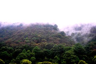
The Lacandon Jungle is an area of rainforest which stretches from Chiapas, Mexico, into Guatemala. The heart of this rainforest is located in the Montes Azules Biosphere Reserve in Chiapas near the border with Guatemala in the Montañas del Oriente region of the state. Although much of the jungle outside the reserve has been cleared, the Lacandon is still one of the largest montane rainforests in Mexico. It contains 1,500 tree species, 33% of all Mexican bird species, 25% of all Mexican animal species, 56% of all Mexican diurnal butterflies and 16% of all Mexico's fish species.

San Andrés is a pre-Columbian site in El Salvador, whose occupation began around the year 900 BC as an agricultural town in the valley of Zapotitán in the department of La Libertad. This early establishment was vacated by the year 250 because of the enormous eruption of the caldera of Lago Ilopango, and was occupied again in the 5th Century, along with many other sites in the valley of Zapotitán. Between 600 and 900 AD, San Andrés was the capital of a Maya polity with supremacy over the other establishments of Valle de Zapotitán.

Yaxha is a Mesoamerican archaeological site in the northeast of the Petén Basin region, and a former ceremonial centre and city of the pre-Columbian Maya civilization. Yaxha was the third largest city in the region and experienced its maximum power during the Early Classic period.
The Central American pine–oak forests is a tropical and subtropical coniferous forests ecoregion in the mountains of northern Central America and Chiapas state in southern Mexico.

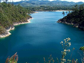
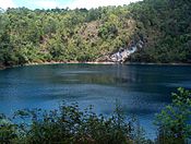
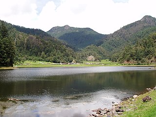
Las Margaritas is a city, and the surrounding municipality of the same name, in the Mexican state of Chiapas. The municipal seat is located some 25 km to the northeast of Comitán de Domínguez, while the municipality extends to the east as far as the border with Guatemala. Part of the Lagunas de Montebello National Park is in the municipality's territory.

Palenque is a city and municipality located in the north of the state of Chiapas, Mexico. The city was named almost 200 years before the nearby Mayan ruins were discovered in the 18th century. The area has a significant indigenous population, mostly of the Ch'ol people, a Mayan descendant. The city is the only urban area in a municipality of over 600 communities, and is surrounded by rainforest. Deforestation has had dramatic effects on the local environment, with howler monkeys occasionally seen in the city as they seek food. While most of the municipality's population is economically marginalized, working in agriculture, the Palenque archeological site is one of the most important tourist attractions for the area and the state of Chiapas. It is the poorest major city in the state of Chiapas.
Lagunas de Zempoala National Park is a natural protected area in Mexico that consists of a group of seven lagoons. In the Nahuatl language, "Zempoala" means "place of many waters." The park is located between the state of Morelos and the state of Mexico.

La Blanca is a Maya pre-Columbian Mesoamerican archaeological site in the municipality of Melchor de Mencos in the northern Petén Department of Guatemala. It has an occupation dating predominantly from the Middle Preclassic period of Mesoamerican chronology. This site belongs to the later period of the Mokaya culture. The site is located in the lower reaches of the Mopan River valley and features a large acropolis complex. Activity at the site has been dated as far back as the Early Classic, with principal occupation of the site occurring in the Late Classic period, although some level of occupation continued into the Early Postclassic.

Casa Blanca is a pre-Columbian Maya archeological site in Chalchuapa, El Salvador. The site possesses several pyramids dating to the Late Preclassic period and the Classic period. This ruin is part of the Chalchuapa archaeological zone and displays influences from the Olmecs and from Teotihuacan. It is closely related to the ruins of Tazumal and San Andrés. The government purchased the park in 1977 and it was given the name of the coffee plantation upon which it was situated. There are many pyramids at Casa Blanca but only two have been partially restored. Casa Blanca is located in the department of Santa Ana. Casa Blanca has been closed to the public and is undergoing restoration work; it has a site museum with exhibits that include Maya ceramics and other artifacts.

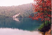
Lago de Camécuaro National Park is located east of the city of Zamora de Hidalgo in the municipality of Tangancícuaro in the state of Michoacán. The park consists of 9.65 hectares of protected area including Camécuaro Lake which is supplied by a series of natural springs. The lake is popular due to its clear water and the vegetation that surrounds the lake. Even though the lake is relatively small, many photographers from all over Mexico come to take photographs of the park's views.
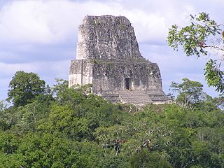
Tikal Temple IV is a Mesoamerican pyramid in the ruins of the ancient Maya city of Tikal in modern Guatemala. It was one of the tallest and most voluminous buildings in the Maya world. The pyramid was built around 741 AD. Temple IV is located at the western edge of the site core. Two causeways meet at the temple; the Tozzer Causeway runs east to the Great Plaza, while the Maudslay Causeway runs northeast to the Northern Zone. Temple IV is the second tallest pre-Columbian structure still standing in the New World, just after the Great Pyramid of Toniná in Chiapas, Mexico, although Teotihuacan's Pyramid of the Sun may once have been taller.
Chontalpa is an area in the Mexican state of Tabasco, which consists of four municipalities in the northwest of the state. Although the name refers to the state's Chontal Maya population, modern Chontalpa is a subregion of the Grijalva Region, and formed with economic concerns in mind. A large percentage of the state's Chontal Maya population does live here, with the municipality of Nacajuca having the largest concentration of indigenous, with the next largest concentration found just east of the region in the Villahermosa area. The subregion's economy is based on agriculture, especially livestock production as well as oil drilling, which have been at odds with each other because of severe degradation of the environment since the mid 20th century. Chontalpa is also home to Tabasco's two main archeological sites, La Venta and Comalcalco, along with numerous smaller sites.
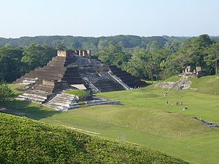
Comalcalco is an ancient Maya archaeological site in the State of Tabasco, Mexico, adjacent to the modern city of Comalcalco and near the southern coast of the Gulf of Mexico. It is the only major Maya city built with bricks rather than limestone masonry and was the westernmost city of the Maya civilisation. Covering an area of 7 km2 (2.7 sq mi), Comalcalco was founded in the Late Classic period and may have been a satellite or colony of Palenque based on architectural similarities between the two. The city was a center of the Chontal Maya people.

Wajxaklajun is a ruin of the ancient Maya civilization situated adjacent to the modern town of San Mateo Ixtatán, in the Huehuetenango Department of Guatemala. Wajxaklajun is considered to be the most important archaeological site in the San Mateo Ixtatán area. The site has been dated to the Classic period. The Chuj Maya consider the city to have been built by their ancestors. The site has similarities with other nearby highland Maya ruins; it is unusual for the presence of a number of stelae, a feature more associated with lowland sites during the Classic period, probably indicating some level of exchange with lowland cities.

The history of Maya civilization is divided into three principal periods: the Preclassic, Classic and Postclassic periods; these were preceded by the Archaic Period, which saw the first settled villages and early developments in agriculture. Modern scholars regard these periods as arbitrary divisions of chronology of the Maya civilization, rather than indicative of cultural evolution or decadence. Definitions of the start and end dates of period spans can vary by as much as a century, depending on the author. The Preclassic lasted from approximately 3000 BC to approximately 250 AD; this was followed by the Classic, from 250 AD to roughly 950 AD, then by the Postclassic, from 950 AD to the middle of the 16th century. Each period is further subdivided:
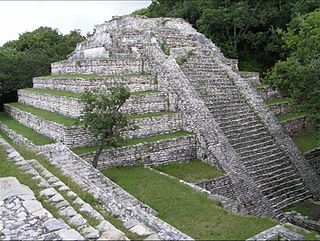
Tenam Puente is an archaeological site of the Maya culture located in the Balum Canan valley, in the municipality of La Trinitaria, 12 kilometers south of Comitán, Chiapas, in Mexico. It is accessed by a deviation from the Pan-American Highway No. 190 that leads to La Trinitaria.