City of Ekurhuleni Metropolitan Municipality

Last updated
Ekurhuleni
East Rand
City of Ekurhuleni Metropolitan Municipality
Coe-logo-sml.png
Nickname(s): 
The East, East Rand
Motto: 
Prosper in Peace
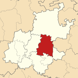
Map of Gauteng with Ekurhuleni highlighted.svg
Location in Gauteng
Coordinates: 26°10′S28°18′E / 26.167°S 28.300°E / -26.167; 28.300
Country South Africa
Province Gauteng
Seat Germiston
Wards 101
Government
[1]
  Type Municipal council
   Executive Mayor Nkosindiphile Xhakaza (ANC)
Area
  Total1,975 km2 (763 sq mi)
Population
 (2011) [2]
  Total3,178,470
  Density1,600/km2 (4,200/sq mi)
Racial makeup (2011)
[2]
   Black African 78.7%
   Coloured 2.7%
   Indian/Asian 2.1%
   White 15.8%
First languages (2011)
[2]
   Zulu 28.6%
   English 11.9%
   Afrikaans 11.8%
   Sepedi 2.4%
  Other45.3%
Time zone UTC+2 (SAST)
Municipal codeEKU
GDP US$ 82.6 billion [3]
GDP per capita US$ 24,468 [3]
Website www.ekurhuleni.gov.za

The City of Ekurhuleni Metropolitan Municipality (Zulu : UMasipala weDolobhakazi laseKurhuleni; Afrikaans : Ekurhuleni Metropolitaanse Munisipaliteit; Northern Sotho : Mmasepala wa Toropokgolo ya Ekurhuleni; Sotho : Masepala wa Toropohadi ya Ekurhuleni) is a metropolitan municipality that forms the local government of the East Rand region of Gauteng, a large suburban region east of Johannesburg. Ekurhuleni means "place of peace" in XiTsonga. Ekurhuleni is one of the five districts of Gauteng and one of the eight metropolitan municipalities of South Africa. The seat of Ekurhuleni is Germiston and the most spoken language is Zulu at 28.6%. The city is home to South Africa's busiest airport, OR Tambo International Airport, which is in the Kempton Park area of Ekurhuleni. [4]

Contents

History

The municipality was established in 2000, the result of a merger between the Eastern Gauteng Services Council, the Khayalami Metropolitan Council, and the previous municipalities of Alberton, Benoni, Boksburg, Brakpan, Edenvale/Lethabong, Germiston, Kempton Park/Tembisa, Nigel and Springs. [5] The planned expansion of Ekurhuleni through the abolition of the Lesedi Local Municipality, which includes Heidelberg, and its absorption into Ekurhuleni after the 2016 municipal elections, were blocked by the High Court of South Africa in 2015. [6]

The name Ekurhuleni meaning place of peace alludes to the fact that the East Rand townships were the site of severe political violence between supporters of the Inkatha Freedom Party and the ANC in the early 1990s, prior to South Africa's first non-racial elections in 1994. [7]

Geography

Ekurhuleni lies on the highveld plateau at about 1600 metres in altitude above sea level (asl). The highest elevation is at the Gillooly's Ridge – Bill Stewart Side – Fisher's Hill at 1772 metres asl. [8] The lowest point is at 1552 metres asl. The city is rich in wetlands, pans, streams and rivers. [9] The city is highly urbanised; however, the north especially has high-potential agricultural land. [10]

Climate

Ekurhuleni has a subtropical highland climate (Cwb) according to the Köppen-Geiger Climate classification. [11] This is a temperate climate of warm summers and dry winters. In the winter months (May - October) the city has a diurnal temperature pattern with a high amplitude, as temperatures can range from freezing at night to mid 20s °C in the day.

The main precipitation falls between October and March with a monthly average precipitation of up to 148 mm which falls usually in convective thundershowers. [12] The daily maximum temperatures in October–March are on average 27°C. The Winter is mostly dry with only a few cold fronts reaching the highveld from the southern Atlantic Ocean. [13]

Climate data for Ekurhuleni
MonthJanFebMarAprMayJunJulAugSepOctNovDecYear
Record high °C (°F)33.8
(92.8)
33.5
(92.3)
35.2
(95.4)
29.4
(84.9)
29.2
(84.6)
28.8
(83.8)
24.5
(76.1)
27.0
(80.6)
33.0
(91.4)
32.5
(90.5)
33.6
(92.5)
33.0
(91.4)
35.2
(95.4)
Mean daily maximum °C (°F)32
(90)
32
(90)
30
(86)
27
(81)
25
(77)
22
(72)
22
(72)
26
(79)
30
(86)
32
(90)
32
(90)
32
(90)
28.5
(83.3)
Daily mean °C (°F)27
(81)
27
(81)
26
(79)
23
(73)
21
(70)
18
(64)
18
(64)
21
(70)
25
(77)
26
(79)
27
(81)
27
(81)
24
(75)
Mean daily minimum °C (°F)14
(57)
13
(55)
13
(55)
10
(50)
6
(43)
2
(36)
2
(36)
4
(39)
8
(46)
11
(52)
13
(55)
14
(57)
9
(48)
Record low °C (°F)6
(43)
0
(32)
1
(34)
−1
(30)
−5
(23)
−7
(19)
−6
(21)
−7
(19)
−3
(27)
2
(36)
1
(34)
0
(32)
−7
(19)
Average rainfall mm (inches)132
(5.2)
86
(3.4)
79
(3.1)
41
(1.6)
13
(0.5)
5
(0.2)
2
(0.1)
7
(0.3)
20
(0.8)
85
(3.3)
114
(4.5)
142
(5.6)
726
(28.6)
Average rainy days (≥ 1.0 mm)2116.514.87.52.91.50.61.95.315.519.122.9129.5
Mean monthly sunshine hours 250.1224.8238.8236.9276.0266.9283.9284.1280.8269.5248.7263.93,124.4
Source 1: meteoblue [14]
Source 2: World Meteorological Organisation (UN) [15]

Main places

Road sign: Ekurhuleni Road sign Ekurhuleni.jpg
Road sign: Ekurhuleni
Ekurhuleni 2001 population density map Ekurhuleni 2001 population density map.svg
Ekurhuleni 2001 population density map

The 2011 census divided the municipality into inter alia the following main places: [16]

PlaceArea (km2)PopulationMost spoken languages
Alberton 77.16121,536Afrikaans 42%, English 34%, Zulu 6%, Sotho 5%, Xhosa 2%, foreign languages 2%
Benoni 175.55158,777English 41%, Afrikaans 19%, Zulu 17%, Pedi 5%, Sotho 3%, Tsonga 3%, foreign languages 3%, Xhosa 2%, Ndebele 2%
Boksburg 162.35260,321Afrikaans 28%, English 18%, Zulu 14%, Pedi 9%, Xhosa 8%, Sotho 7%, Tsonga 4%, foreign languages 3%
Brakpan 182.8173,080Afrikaans 47%, English 16%, Zulu 14%, Sotho 4%, Pedi 3%, foreign languages 2%, Tsonga 2%, Xhosa 2%, Tswana 2%
Daveyton 14.45127,967Zulu 37%, Pedi 13%, Xhosa 11%, Sotho 10%, Tsonga 9%, Tswana 5%, Ndebele 3%, English 2%, foreign languages 2%
Duduza 11.2373,295Zulu 64%, Sotho 16%, Xhosa 5%, Pedi 2%, Tswana 2%
Edenvale 20.0349,292English 72%, Afrikaans 11%, foreign languages 4%, Zulu 3%
Etwatwa 20.83151,866Zulu 44%, Tsonga 12%, Pedi 12%, Sotho 7%, Xhosa 6%, Ndebele 6%, Swazi 2%, Tswana 2%
Germiston 143.27255,863English 24%, Afrikaans 16%, Zulu 16%, Xhosa 9%, Pedi 7%, Sotho 7%, foreign languages 5%, Tsonga 4%, Venda 2%, Tswana 2%
Katlehong 55.36407,294Zulu 37%, Sotho 22%, Xhosa 13%, Pedi 9%, Tsonga 6%, English 2%
Kempton Park 149.05171,575Afrikaans 34%, English 26%, Zulu 8%, Pedi 7%, foreign languages 4%, Sotho 4%, Tswana 3%, Xhosa 3%, Tsonga 2%
Kwa-Thema 14.70103,727Zulu 55%, Xhosa 8%, Sotho 7%, Pedi 7%, Tswana 6%, Ndebele 4%, Tsonga 2%, English 2%, Swazi 2%
Langaville 10.1054,710Zulu 46%, Pedi 11%, Tsonga 10%, Xhosa 8%, Sotho 6%, Ndebele 4%, Swazi 3%, English 2%, Tswana 2%
Nigel 139.0738,318Afrikaans 43%, Zulu 23%, English 16%, Sotho 5%, Xhosa 2%
Springs 183.50121,610Afrikaans 30%, Zulu 20%, English 15%, Pedi 8%, Xhosa 7%, Sotho 5%, Tsonga 3%, foreign languages 3%, Tswana 2%
Thembisa 42.08463,109Pedi 33%, Zulu 21%, Tsonga 13%, Xhosa 7%, Sotho 6%, Tswana 3%, Ndebele 3%, Venda 3%, foreign languages 2%, English 2%
Tokoza 9.43105,827Zulu 40%, Sotho 21%, Xhosa 18%, Pedi 5%, Tsonga 3%
Tsakane 19.75135,994Zulu 57%, Sotho 10%, Pedi 7%, Xhosa 6%, Tsonga 4%, Tswana 3%, Ndebele 3%, English 2%
Vosloorus 32.10163,216Zulu 46%, Sotho 17%, Xhosa 8%, Pedi 7%, Tsonga 5%, Tswana 4%, English 3%
Wattville 2.1725,667Zulu 47%, Sotho 13%, Pedi 10%, Xhosa 7%, Tswana 5%, Tsonga 5%, English 2%, foreign languages 2%, Ndebele 2%

Parks and nature

Germiston Lake is a natural pan in the Elsburgspruit system and has a catchment area of 1174ha. It is fed mostly by surface runoff water and storm water drains. The lake is one of the cleanest bodies of water in South Africa.[ citation needed ] It has a size of 57.4 ha and a maximum capacity of 2839×. Its depth is approximately 8 metres. [17] [18] On the banks of the lake are a recreational park with playground equipment and braai areas as well as a rowing club and golf club.

A wetland of note is the Blesbokriver wetland which stretches over an area of 1858ha. [19]

The Bullfrog Pan is almost 10 hectares and is home to more than 150 bird species. [20]

Landmarks

In 2017, the Chris Hani memorial at Thomas Nkobi Memorial Park in Boksburg was revealed during the 22nd commemoration of his death. The Chris Hani memorial site consists of the Monument, the Walk of Remembrance and the Wall of Remembrance which recognizes the historical events, places and people associated with the liberation struggle of South Africa. [20]

Chris Hani Monument in Boksburg, Ekurhuleni Chris Hani Monument.png
Chris Hani Monument in Boksburg, Ekurhuleni

The Thokoza Wall of Remembrance commemorates the people who died in the fight between the Inkatha Freedom Party and the residents. [20]

Arts and culture

Ekurhuleni has a rich cultural life. In 2017, the Thami Mnyele Fine arts award had its 30th anniversary. [21]

The local music scene is well and alive and Ekurhuleni gave rise to a few notable music stars.

O.R. Tambo Narrative Centre tells visitors all about the lives and contributions of the Tambo couple towards the dismantling of Apartheid in South Africa. It is situated on the banks of the Leeupan Wetland. It also has an exhibition of environmental education aimed at children.

Since 2016, Ekurhuleni has hosted the Ekurhuleni International Film Festival. [22]

Demographics

In 2016, 3,379,104 people lived in Ekurhuleni, of whom 22.7% were under 15 years old, 71.2% were between the ages of 15-64 and 6.1% were older than 65 years old. Ekurhuleni had 1,299,490 households with an average people per household number of 2.6. 80.2% of people lived in formal dwellings and 52.9% owned housing. [23]

The following statistics are from the 2001 census. [24]

Ekurhuleni 2001 dominant language map Ekurhuleni 2001 dominant language map.svg
Ekurhuleni 2001 dominant language map
Population pyramid 2011
%MalesAgeFemales%
n/d
 
85+
 
n/d
n/d
 
80–84
 
n/d
0.53
 
75–79
 
0.89
0.65
 
70–74
 
0.74
1.04
 
65–69
 
1.07
1.46
 
60–64
 
1.47
1.95
 
55–59
 
1.91
2.37
 
50–54
 
2.26
3.02
 
45–49
 
2.65
3.72
 
40–44
 
3.18
4.87
 
35–39
 
4.18
5.75
 
30–34
 
5.05
5.59
 
25–29
 
5.13
4.04
 
20–24
 
4.01
3.21
 
15–19
 
3.29
3.67
 
10–14
 
3.69
4.41
 
5–9
 
4.40
4.87
 
0–4
 
4.90
LanguagePopulation%
IsiZulu 908 00228.81%
English 377 93511.99%
Afrikaans 375 61111.8%
Sepedi 359 24511.40%
Sesotho 315 80610.02%
IsiXhosa 252 7578.02%
XiTsonga 208 8656.63%
Setswana 90 3072.87%
Other 81 8782.60%
IsiNdebele 75 1502.38%
Tshivenda 48 2271.53%
SiSwati 44 9671.43%
Sign Language .0.4%

Gender

Germiston Germiston CBD.jpg
Germiston
The Rhodesfield suburb of Kempton Park Rhodesfield Kempton.jpg
The Rhodesfield suburb of Kempton Park
GenderPopulation%
Male1 627 72452.21%
Female1 550 74747.79%

Ethnic groups

A street in Lakefield Benoni Ekurhuleni.jpg
A street in Lakefield
Ethnic groupPopulation%
Black African2 502 76978.74%
White502 43915.81%
Coloured85 9102.70%
Indian/Asian68 0582.14%
The CBD of Benoni Benoni CBD.jpg
The CBD of Benoni

Education

Ekurhuleni has two school districts: Ekurhuleni North and Ekurhuleni South. [25] There are 671 schools in Ekurhuleni, of which 137 are independent. [26] [27] Ekurhuleni has two colleges of further education and training (FET) [28] [29] as well as two centres of adult education and training (AET). [30] The municipal government under Executive Mayor Mzwandile Masina conducted a feasibility study and lobbied the national government to establish a university in Ekurhuleni [31] which was formally announced by President Cyril Ramaphosa in the 2020 State of the Nation Address.

Governance and politics

The governance of Ekurhuleni is set out by Chapter 7 of the Constitution of South Africa which governs the operation and function of local government in South Africa. The Local Government: Municipal Structures Act 117 of 1998 states that the minister responsible for local government, namely the Minister of Cooperative Governance and Traditional Affairs, is responsible for the designation of municipalities. As per the act and regulations issued by the Minister, Ekurhuleni is designated as a category A municipality and is thus a metropolitan municipality. The external boundaries of the municipality and subsequently the remit of the jurisdiction of the metropolitan government is regulated by the Municipal Demarcation Board. [32]

As of 11 April 2011, the Municipal Council approved the separation of the legislative and executive functions of the metropolitan government. [33] The executive head of the municipality is the Executive Mayor, who as of 31 March 2023 is Sivuyile Ngodwana, of the African Independent Congress. [34] Under Section 56 of the Municipal Structures Act, the Executive Mayor is responsible for directing and monitoring, and presiding over Mayoral Committee. [35] The Mayoral Committee comprises the administrative branch of the municipality and is responsible for bringing to effect the by-laws of the Municipal Council, administering the responsibilities designated by national and provincial legislation, as well as providing for the political oversight for the functioning of the city structures. [33] A professional civil servant known as the City Manager, currently Dr Imogen Mashazi, [36] is responsible for the technical and managerial direction and oversight of the municipality. [37]

In 2014/2015, the city ranked highest out of all metros in South Africa in the Business Day Index, measuring how well cities and towns spend resident's money. [38]

The municipal council consists of 224 members elected by mixed-member proportional representation. Of these 224, 112 are elected by first-past-the-post voting in 112 wards, while the remaining 112 are chosen from party lists so that the total number of party representatives is proportional to the number of votes received. In the 2021 South African municipal election, no party obtained a majority of seats on the council.

The following table shows the results of the 2021 election. [39]

Ekurhuleni local election, 1 November 2021
PartyVotesSeats
WardListTotal %WardListTotal
African National Congress 254,782257,186511,96838.2%78886
Democratic Alliance 194,739190,305385,04428.7%323365
Economic Freedom Fighters 92,91989,045181,96413.6%03131
ActionSA 39,08949,39588,4846.6%01515
Freedom Front Plus 21,33023,31844,6483.3%088
Patriotic Alliance 12,63012,52425,1541.9%224
Inkatha Freedom Party 8,3359,88518,2201.4%033
African Independent Congress 8,1939,12517,3181.3%033
African Christian Democratic Party 5,5245,79511,3190.8%022
Independent candidates 8,0258,0250.6%00
Independent Ratepayers Association of SA5,2422,4067,6480.6%011
Independent Citizens Movement2,9603,0265,9860.4%011
Pan Africanist Congress of Azania 2,0892,8974,9860.4%011
African Transformation Movement 2,1332,2044,3370.3%011
National Freedom Party 1,4011,9263,3270.2%011
United Democratic Movement 1,4281,7023,1300.2%011
Congress of the People 1,5111,3402,8510.2%011
21 other parties7,5678,74216,3091.2%000
Total669,897670,8211,340,718112112224
Valid votes669,897670,8211,340,71898.5%
Spoilt votes 9,87910,11319,9921.5%
Total votes cast679,776680,9341,360,710
Voter turnout688,479
Registered voters1,575,840
Turnout percentage43.7%

Economy

As of 2014, the GDP of Ekurhuleni was estimated at over US$55 billion (PPP), being US$17,361 per person. [3] Ekurhuleni has an active workforce of 1.6 million people of whom 28.8% are unemployed. [24] Ekurhuleni makes up 6.2% of national production.

Ekurhuleni is home to the Rand Refinery, the largest integrated single-site precious metals refining and smelting complex in the world. [40]

Airways Park, the head office of South African Airways SAA-Airways Park-002.jpg
Airways Park, the head office of South African Airways
Professor John D. Kasarda with Ekurhuleni mayor Mondli Gungubele Gungubele Kasarda Ekurhuleni 2012.jpg
Professor John D. Kasarda with Ekurhuleni mayor Mondli Gungubele

Manufacturing

The city is an important manufacturing centre in South Africa, contributing 32% of manufacturing production. [41] The city has been described as "the workshop of the country". [42] It contributes 11% to the GVA of South Africa. [43]

Ekurhuleni has held the "Manufacturing Indaba" Conference every year since 2014. This two-day conference provides contacts and networking between business owners, industry owners, capital providers, experts and the government. [44]

Infrastructure

Road network

Ekurhuleni is connected to the main motorways in South Africa via the M2, N3, N17, R21, R24 and R59 highways. As Ekurhuleni is part of the Johannesburg Conurbation, Transport routes in Ekurhuleni share the same metropolitan route numbering system as Johannesburg.

The road network in Ekurhuleni spans 8,024 km of paved roads and approximately 1,200 km of gravel road. [45]

Public transport

Ekurhuleni is one of 13 cities and towns in South Africa to implement the bus rapid transit (BRT) system. Phase 1 of the project runs from Tembisa to Vosloorus via Kempton Park and the OR Tambo International Airport. New routes have been integrated from Katlehong to Rhodesfield, from Vosloorus to Rhodesfield, and from Reiger Park to Rhodesfield. [46] Passengers are served by Metrorail which sustains the passenger rail network in the Western Cape, Gauteng, KwaZulu-Natal and the Eastern Cape. Seven train lines serve Ekurhuleni. [47]

Rail

Ekurhuleni has the largest rail hub in South Africa used by Transnet. [41]

Aviation

Ekurhuleni aerotropolis Ekurhuleni Aerotropolis.jpg
Ekurhuleni aerotropolis

Several airline companies are headquartered in the Kempton Park area of Ekurhuleni.

Ekurhuleni is Gauteng's first aerotropolis. [48] This is a metropolis with an airport at its centre. One should be able to get to the airport from anywhere in Ekurhuleni in 25 min. The major aim will be logistics and connecting the local industry and agriculture to the world markets.

O.R. Tambo International Airport has two terminals handling domestic and international flights. Terminal A handles international traffic and Terminal B domestic flights. The airport services airlines from all five continents and plays a vital role in serving the local, regional, intra- and inter-continental air transport needs of South Africa and sub-Saharan Africa. It is the biggest and busiest airport in Africa. OR Tambo International handles more than 20 million passengers per year and employs more than 18,000 people. [49]

South African Airways, the flagship air carrier of South Africa, and its subsidiary South African Express have their head offices in Ekurhuleni. [4] [50] [51] Mango, a low cost airline owned by SAA, is headquartered on the grounds of OR Tambo International Airport. [52]

Federal Air has its headquarters on the OR Tambo International Airport grounds. [53] 1time has its head office in the Isando Industrial Park. [54] Safair's head office is in Kempton Park. [55]

Airports Company South Africa has its head office in Bedfordview, Ekurhuleni. [56] TAAG Angola Airlines has an office in Bedfordview. [57]

Stormwater systems

There are 11,318 storm water systems and a total lengths of pipes and channels of more than 3800 km. [45]

Sports and recreation

Ekurhuleni has at least 16 golf courses and is home to the international Golf Tournament the South African Open held at Glendower Golf Club. [58]

There is an over 100 year old rowing club at the bank of Germiston Lake, [59] and over 30 swimming pools can be found in the city. [60]

Ekurhuleni United FC play in the fourth division of South African Football. [61]

Ekurhuleni has the Ekurhuleni masters league, a soccer league of retired pros and talented players who did not make the cut. [62]

38 eco "outdoor gyms" can be found in Ekurhuleni.

Management

Although Eskom has identified Ekurhuleni as a municipality with a poor payment record, its 2021 debt with the power utility amounted to R8 million which compared favourably with the rest of Gauteng. [63]

Notable people from Ekurhuleni


Related Research Articles

<span class="mw-page-title-main">Gauteng</span> Province in South Africa

Gauteng is one of the nine provinces of South Africa.

<span class="mw-page-title-main">Benoni, South Africa</span> Place in Gauteng, South Africa

Benoni is a town on the East Rand, Gauteng, South Africa, some 26 kilometres (16 mi) east of Johannesburg, within the City of Ekurhuleni municipality.

<span class="mw-page-title-main">Midrand</span> Place in Gauteng, South Africa

Midrand is a former municipality in central Gauteng, South Africa. Situated in-between Centurion and Sandton, Midrand now forms part of the City of Johannesburg Metropolitan Municipality.

Eastgate Shopping Centre is a super-regional shopping centre in Bedfordview, near Bedford Gardens and the Johannesburg city centre in Gauteng. It remains one of the largest centres in the country and is the fourth largest shopping centre in Gauteng, after Mall of Africa, Sandton City and Menlyn Park. The centre lies next to the R24 airport freeway, between the Johannesburg CBD to the west and O. R. Tambo International Airport to the east.

<span class="mw-page-title-main">East Rand</span> Eastern region of Gauteng, South Africa

The East Rand is a major urban area located in the Gauteng province of South Africa. It is the urban eastern part of Witwatersrand that is functionally merged with the Johannesburg conurbation. The region extends from Alberton in the west to Springs in the east, and south down to Nigel. It includes the towns of Bedfordview, Benoni, Boksburg, Brakpan, Edenvale, Germiston, Kempton Park, Linksfield and Modderfontein. The East Rand is known as the transport hub of Johannesburg and includes Africa's largest and second busiest airport, OR Tambo International Airport.

<span class="mw-page-title-main">Greater Johannesburg</span> Metropolitan conurbation in Gauteng, South Africa

The term Greater Johannesburg may refer to:

<span class="mw-page-title-main">N3 Eastern Bypass (Johannesburg)</span> Road in South Africa

The N3 Eastern Bypass is a section of the Johannesburg Ring Road that forms a beltway around the city of Johannesburg, South Africa, as part of the N3. The first section of the freeway opened in 1971, from Buccleuch to the interchange with Main Reef Road in Germiston. This is one reason why Germiston is listed as the southbound destination of this route, from the Buccleuch to Geldenhuys Interchanges, rather than to the Elands Interchange south of Germiston. The remaining section from Main Reed Road to Black Reef Road, which included the construction of the Geldenhuys Interchange, was opened in 1977, linking the Eastern Bypass with the N3 freeway to Heidelberg. The interchange at Main Reef Road was removed.

<span class="mw-page-title-main">Edenvale, South Africa</span> Place in Gauteng, South Africa

Edenvale is a small city on the East Rand in Gauteng, South Africa. The greater Edenvale area has an estimated population of 70,000, including Greenstone, Harmelia, Highway Gardens, Buurendal and Croydon. Edenvale is part of the Ekurhuleni Metropolitan Municipality. It lies about halfway between the O.R. Tambo International Airport and the Johannesburg city centre and is located 12 km by road from Sandton and about 9 km from the closest Gautrain station.

<span class="mw-page-title-main">Germiston</span> Place in Gauteng, South Africa

Germiston, also known as kwaDukathole, is a city in the East Rand region of Gauteng, South Africa, administratively forming part of the City of Ekurhuleni Metropolitan Municipality since the latter's establishment in 2000. It functions as the municipal seat of Ekurhuleni, hosting the municipal council and administration.

<span class="mw-page-title-main">Kempton Park, South Africa</span> Place in Gauteng, South Africa Postal address 1619

Kempton Park is a city in the East Rand region of Gauteng province, South Africa. It is part of the City of Ekurhuleni Metropolitan Municipality. It is situated south of Thembisa, one of the largest townships in South Africa, which is also part of Ekurhuleni. South Africa's busiest airport, O. R. Tambo International Airport is located in Kempton Park.

<span class="mw-page-title-main">Bedfordview</span> Place in Gauteng, South Africa

Bedfordview is an affluent suburb in western Ekurhuleni, sharing an administrative boundary with the City of Johannesburg Metropolitan Municipality, Gauteng, South Africa. Bedfordview has been part of the City of Ekurhuleni Metropolitan Municipality since 2000. The Eastgate Shopping Centre, one of the biggest in Africa when first built, is also located here.

<span class="mw-page-title-main">R21 (South Africa)</span> Road in South Africa

The R21 is a major north–south provincial route in eastern Gauteng Province, South Africa. Built in the early 1970s, it remains one of two freeways linking Pretoria with Johannesburg, via the R24. As the eastern of the two freeways, it links the Pretoria city centre with OR Tambo International Airport and Boksburg. Between the Solomon Mahlangu Drive on-ramp in Monument Park, Pretoria, and the N12 interchange in Boksburg, the R21 is an 8 lane highway and motorway (freeway), with 4 lanes in each direction. It has off-ramps leading to Irene, Olifantsfontein, Benoni, and Kempton Park. The route intersects the N1 highway near Centurion, the R24 near the airport, the N12 and N17 in Boksburg, and the N3 near Vosloorus on the East Rand, where it ends. The section from the N12 to the N3 is not a freeway. The R21 is also designated as the P157.

<span class="mw-page-title-main">R24 (South Africa)</span> Road in South Africa

The R24 is a major East-West provincial route in the Gauteng and North West provinces that links OR Tambo International Airport with Rustenburg via Johannesburg, Krugersdorp and Magaliesburg. The process of renaming the streets and freeway that form the route from Krugersdorp eastward to OR Tambo International after anti-apartheid stalwart Albertina Sisulu was completed in 2013.

<span class="mw-page-title-main">N12 (South Africa)</span> National road in South Africa

The N12 is a national route in South Africa which runs from George through Beaufort West, Kimberley, Klerksdorp and Johannesburg to eMalahleni.

<span class="mw-page-title-main">Lesedi Local Municipality</span> Local municipality in Gauteng, South Africa

Lesedi Municipality is a local municipality within the Sedibeng District Municipality, in the Gauteng province of South Africa. Heidelberg is the seat of the municipality. During the first war of independence, Heidelberg served as capital of the South African Republic, from 1880 to 1883.

The M57 is a major metropolitan route in Greater Johannesburg, South Africa. A north/south route, it connects Germiston with the south-eastern suburbs of Pretoria via Kempton Park and Olifantsfontein. For most of its length, it is an alternative route to the R21 freeway.

The M96 is a short metropolitan route in Greater Johannesburg, South Africa. The entire route is within the CBD of Kempton Park and consists of two one-way streets.

The M99 is a short metropolitan route in Greater Johannesburg, South Africa. For its entire route, it parallels the R24 highway in the City of Ekurhuleni Metropolitan Municipality.

Olifantsfontein, also known as Clayville, is a small town on the East Rand in the Gauteng Province of South Africa. It is located at the north-western corner of the City of Ekurhuleni Metropolitan Municipality, just north of the Thembisa township. As of the 2011 Census, the town has a population of 14,526 people.

The Tambo Memorial Hospital is a regional hospital located in Boksburg (Ekurhuleni) in Gauteng Province, South Africa.

References

Citations

  1. "Contact list: Executive Mayors". Government Communication & Information System. Archived from the original on 14 July 2010. Retrieved 22 February 2012.
  2. 1 2 3 "Statistics by place". Statistics South Africa. Retrieved 27 September 2015.
  3. 1 2 3 "Global city GDP 2014". Brookings Institution . Retrieved 7 November 2017. East Rand
  4. 1 2 "Background [ permanent dead link ]." Ekurhuleni. 3 (3/8). Retrieved on 30 September 2009.
  5. "IDP & SDBIP 2013/14". Ekurhuleni Metropolitan Municipality. 2013. p. 11. Archived from the original on 2017-08-25. Retrieved 2017-11-07.
  6. "DA wins court case - Heidelberg Nigel Heraut". 22 September 2015.
  7. "Xenophobia: The painful history of black-on black violence - OPINION - Politicsweb". www.politicsweb.co.za.
  8. CITY OF EKURHULENI [@City_Ekurhuleni] (July 25, 2017). "@morri85 Giloolys ridge – Bill Stewart Side –Fishers hill is highest point at +/- 1772m Lowest point is about +/- 1552m 👍🏼" (Tweet) via Twitter.
  9. "Archived copy". Archived from the original on 2017-08-31. Retrieved 2017-07-25.{{cite web}}: CS1 maint: archived copy as title (link)
  10. "Archived copy". www.arcgis.com. Archived from the original on 31 August 2017. Retrieved 13 January 2022.{{cite web}}: CS1 maint: archived copy as title (link)
  11. page5
  12. "Climate Germiston". meteoblue.
  13. "".
  14. "Climate Germiston" . Retrieved 24 July 2017.
  15. "UNdata|record view|Sunshine". United Nations Statistics Division. Retrieved 24 July 2017.
  16. "Census 2011: Metropolitan Municipality: Ekurhuleni".
  17. "Data" (PDF). www.wrc.org.za. Archived from the original (PDF) on 2017-08-31. Retrieved 25 July 2017.
  18. "Ekurhuleni – Gauteng Tourism Authority". gauteng.net.
  19. "WETLAND - Blesbokspruit". Archived from the original on 8 August 2017. Retrieved 24 July 2017.
  20. 1 2 3 "Story Map Journal".
  21. "Thami Mnyele Fine Art Awards 2017 Competition - Art.co.za - Art in South Africa". www.art.co.za.
  22. "About Us - Ekurhuleni International Film Festival". Archived from the original on 2017-12-04. Retrieved 2017-11-25.
  23. "City of Ekurhuleni Metropolitan Municipality - Overview". Localgovernment.co.za. Retrieved 2018-07-22.
  24. 1 2 Statistics South Africa. "Local Municipality | Statistics South Africa". Statssa.gov.za. Retrieved 2018-07-22.
  25. "Education Districts". www.education.gov.za.
  26. "Archived copy". Archived from the original on 2018-07-22. Retrieved 2017-07-24.{{cite web}}: CS1 maint: archived copy as title (link)
  27. "Archived copy". Archived from the original on 2018-07-22. Retrieved 2017-07-24.{{cite web}}: CS1 maint: archived copy as title (link)
  28. "Archived copy". Archived from the original on 2018-07-22. Retrieved 2017-07-24.{{cite web}}: CS1 maint: archived copy as title (link)
  29. "Archived copy". Archived from the original on 2018-07-22. Retrieved 2017-07-24.{{cite web}}: CS1 maint: archived copy as title (link)
  30. "Archived copy" (PDF). Archived from the original (PDF) on 2017-08-09. Retrieved 2017-07-24.{{cite web}}: CS1 maint: archived copy as title (link)
  31. "Symposium CoE University". City of Ekurhuleni. CoE. Archived from the original on 1 December 2017. Retrieved 18 November 2017.
  32. "About the Municipal Demarcation Board". Municipal Demarcation Board. Retrieved 23 January 2022.
  33. 1 2 "The Council". Ekurhuleni. Retrieved 23 January 2023.
  34. Madia, Tshidi (8 November 2022). "Tania Campbell Re-elected Mayor of Ekurhuleni". EyeWitness News .
  35. South African Local Government Association. "Role and responsibilities of mayors" (PDF). Local Government Law Bulletin.
  36. "City of Ekurhuleni". Government of South Africa .
  37. "The Office of the City Manager". Ekurhuleni.
  38. "Info" (JPG). pbs.twimg.com.
  39. "Election Result Table for LGE2021 — Ekurhuleni". wikitable.frith.dev. Retrieved 2021-11-09.
  40. www.sonaruniversal.co.za, Susan Craig, Sonar Universal. "About Us : Our Company". www.randrefinery.com. Archived from the original on 2017-07-13. Retrieved 2017-07-21.{{cite web}}: CS1 maint: multiple names: authors list (link)
  41. 1 2 "Data" (PDF). www.nwu.ac.za. Archived from the original (PDF) on 2017-08-31. Retrieved 2017-07-21.
  42. thamashni naidoo. "Ekurhuleni – still South Africa's manufacturing powerhouse". Engineeringnews.co.za. Retrieved 2018-07-22.
  43. CITY OF EKURHULENI [@City_Ekurhuleni] (June 27, 2017). "Manufacturing in #InvestCoE Constitutes 27,9 % GVA and 11% SA's GVA. #MI2017" (Tweet) via Twitter.
  44. "Home - Manufacturing Indaba". Manufacturing Indaba.
  45. 1 2 "Annual report" (PDF). mfma.treasury.gov.za. 2016.
  46. About The Author Glen Tancott. "Developing a critical hub in Ekurhuleni". Infrastructure news. Retrieved 2018-07-22.{{cite web}}: |author= has generic name (help)
  47. "Metrorail". Archived from the original on 2010-02-09. Retrieved 2010-08-09.
  48. "Archived copy". Archived from the original on 2018-03-16. Retrieved 2017-07-20.{{cite web}}: CS1 maint: archived copy as title (link)
  49. "Archived copy". Archived from the original on 2018-03-16. Retrieved 2017-07-25.{{cite web}}: CS1 maint: archived copy as title (link)
  50. "Legal Information - (EU) Archived 2009-09-12 at the Wayback Machine ." South African Airways. Retrieved on 24 June 2009.
  51. "Contact Us Archived 2008-05-09 at the Wayback Machine ." South African Express. Retrieved on 30 September 2009.
  52. "Contact Us Archived 2009-09-16 at the Wayback Machine ." Mango. Retrieved on 30 September 2009. "Mezzanine Level Domestic Departure Terminal OR Tambo International Airport 1627"
  53. "Contact details Archived 2009-09-17 at the Wayback Machine ." Federal Air. Retrieved on 30 September 2009.
  54. "Contact Us Archived 2011-05-31 at the Wayback Machine ." 1time. Retrieved on 28 October 2009.
  55. "Contact." Safair. Retrieved on 1 March 2010.
  56. "Contact us Archived 2011-07-20 at the Wayback Machine ." Airports Company South Africa. Retrieved on 6 February 2011. "Physical address: 24 Johnson Road The Maples Office Park - Bedfordview Johannesburg."
  57. "TAAG Offices Archived 2010-01-29 at the Wayback Machine ." TAAG Angola Airlines. Retrieved on 23 January 2010.
  58. "Glendower Golf Club – Gauteng Tourism Authority". www.gauteng.net.
  59. "Victoria Lake Rowing Club, Germiston > Home". Vlc-rowing.co.za. Retrieved 2018-07-22.
  60. "EKURHULENI COMMUNITY POOLS READY AND SET FOR THE SWIMMING SEASON". Archived from the original on 2017-08-31. Retrieved 2017-07-24.
  61. "SAB League Ekurhuleni - Ekurhuleni City FC". ekurhuleni.leaguerepublic.com.
  62. "Fixtures – Ekurhuleni Master's League". Ekfleague.co.za. Retrieved 2018-07-23.
  63. Khumalo, Sibongile (2 September 2021). "Eskom wins judgment against Emfuleni municipality over R1.3 billion debt". news24.com. fin24. Retrieved 6 September 2021.

General and cited sources