
London Trams, previously Tramlink and Croydon Tramlink, is a light rail tram system serving Croydon and surrounding areas in South London, England. It began operation in 2000, the first tram system in the London region since 1952. It is managed by London Trams, a public body part of Transport for London (TfL), and has been operated by FirstGroup since 2017. Tramlink is one of two light rail networks in Greater London, the other being the Docklands Light Railway.

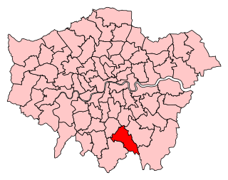
The London Borough of Croydon is a London borough in south London, part of Outer London. It covers an area of 87 km2 (33.6 sq mi). It is the southernmost borough of London. At its centre is the historic town of Croydon from which the borough takes its name; while other urban centres include Coulsdon, Purley, South Norwood, Norbury, New Addington, Selsdon and Thornton Heath. Croydon is mentioned in Domesday Book, and from a small market town has expanded into one of the most populous areas on the fringe of London. The borough is now one of London's leading business, financial and cultural centres, and its influence in entertainment and the arts contribute to its status as a major metropolitan centre. Its population is 390,719, making it the largest London borough and sixteenth largest English district.

Purley is an area of the London Borough of Croydon in London, England, 11.7 miles (18.8 km) south of Charing Cross, with a history going back at least 800 years. It was originally granted as an estate from holdings at Sanderstead and until as a district of Surrey and then, with neighbouring Coulsdon, as an urban district that became an electoral ward of the London Borough of Croydon, becoming part of the ceremonial county of London, in 1965. In 2018 the Purley ward was divided into two: Purley and Woodcote, and Purley Oaks and Riddlesdown.
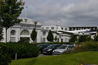
Croydon Airport was the UK's only international airport during the interwar period. It opened in 1920, located in Croydon, then part of Surrey. Built in a Neoclassical style, it was developed as Britain's main airport, handling more cargo, mail, and passengers than any other UK airport at the time. Innovations at the site included the world's first air traffic control and the first airport terminal. During World War II the airport was named RAF Croydon as its role changed to that of a fighter airfield during the Battle of Britain; and in 1943 RAF Transport Command was founded at the site, which used the airport to transport thousands of troops into and out of Europe.

Croydon is a large town in South London, England, 9.3 miles (15.0 km) south of Charing Cross. Part of the London Borough of Croydon, a local government district of Greater London, it is one of the largest commercial districts in Greater London, with an extensive shopping district. The entire town had a population of 192,064 as of 2011, whilst the wider borough had a population of 384,837.

East Croydon is a railway station and tram stop in Croydon, Greater London, England, and is located in Travelcard Zone 5. At 10 miles 28 chains from London Bridge, it is the 20th busiest station in Britain, was the 10th busiest in 2020–21, is the busiest national rail station in London outside of fare zones 1 and 2 and is one of the busiest non-terminal stations in the country. It is one of three railway stations in the London Borough of Croydon with Croydon in their name, the others being West Croydon and South Croydon. A Tramlink tram stop is located immediately outside the main station entrance.

West Croydon is a combined railway, bus station and tram stop in Croydon, south London. It is served by National Rail, London Overground, Tramlink and London Buses services and is in Travelcard Zone 5.

South Croydon in south London is the area surrounding the valley south of central Croydon and running as far south as the former Red Deer public house on the Brighton Road. It is bounded by Waddon to the West and Selsdon and Sanderstead to the East. It is part of the South Croydon (CR2) post town and in the London Borough of Croydon.
Croydon Central is a constituency created in 1974 and is represented in the House of Commons of the UK Parliament since 2017 by Labour MP Sarah Jones. The seat bucked the trend in national results in 2019, with Labour holding the seat with a slightly increased majority.

Croydon North is a constituency represented in the House of Commons of the UK Parliament since 2012 by Steve Reed of Labour Co-op. The seat was created in 1918 and split in two in 1955 and re-devised in a wholly different form in 1997.

Croydon South is a constituency created in 1974 and represented in the House of Commons of the UK Parliament since 2015 by Chris Philp, a Conservative.

Elections for the Croydon London Borough Council are held every four years to elect 70 councillors. The last ward boundary changes came into force at the 2018 local elections.

Elections to Croydon Council in London, England were held on 4 May 2006. The whole council was up for election for the first time since the 2002 election. The Labour Party lost control of the council to the Conservative Party for the first time since 1994.

Croydon University Hospital, known from 1923 to 2002 as Mayday Hospital and from 2002 to 2010 as Croydon Hospital, is a large NHS hospital in Thornton Heath in south London, England run by Croydon Health Services NHS Trust. It is a District General Hospital with a 24-hour Accident and Emergency department. The hospital is based on a 19-acre (7.7 ha) site in Thornton Heath to the north of central Croydon.

The Shire of Croydon is a local government area in western Queensland, Australia. The shire, administered from the town of Croydon, covers an area of 29,498 square kilometres (11,389.2 sq mi). The council consists of a mayor plus four councillors, each of whom represents the entire Shire.

Croydon London Borough Council is the local authority for the London Borough of Croydon in Greater London, England. It is a London borough council, one of 32 in the United Kingdom capital of London. Croydon is divided into 28 wards, electing 70 councillors.

Croydon Cenotaph is a war memorial, in Croydon, London, England. It is located outside the Croydon Clocktower arts complex, on Katharine Street in Croydon.
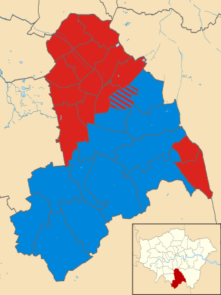
The 2018 Croydon Council election took place on 3 May 2018 to elect members of Croydon Council in England. This was on the same day as other London local elections.

In the 2022 Croydon London Borough Council election, on 5 May 2022, all 70 members of Croydon London Borough Council, and the Mayor of Croydon, were up for election. The elections took place alongside the local elections in the other London boroughs and elections to local authorities across the United Kingdom. Jason Perry of the Conservative Party narrowly won the mayoral election.


