The earliest known inhabitants of the area now called Randburg were indigenous tribes who roamed the open veld. Evidence of their Iron Age craftsmanship, including tools and pottery, can still be found on some of the local koppies (small hills). However, much about their culture and history remains undocumented and largely unknown.
The Boer Settlements
Randburg's recorded history began in the mid-19th century when Boer pioneers settled four farms in the area: Klipfontein, Driefontein, Olievenhoutspoort, and Boskop. These farms were later subdivided among the sons of the original farmers, following the tradition of the time. Driefontein, one of the largest farms, originally stretched from the northern boundary of Bryanston to present-day Braamfontein, eventually being divided into nine plots.
One of the plots was purchased by Charles Rocher, a Frenchman from Bordeaux,[3] who named his section after his hometown. Rocher was an early pioneer of Cape deciduous fruit farming in the Transvaal, and remnants of his orchards can still be found on some of the older plots in the area. Another portion of the Boskop farm was bought by Dale Lace, a well-known Rand entrepreneur, who converted a farmhouse into a country residence. This home, restored by Tom Kelly in 1929 and renamed "Hy-Many," is currently under consideration for designation as a National Monument.
Hy-Many
Randburg and the Gold Rush
The discovery of gold in the region brought significant attention to Randburg. Wealthy English investors, such as Abe Bailey, saw the area as a prime opportunity for investment. Streets like Carlton Road, Church Street, and Pritchard Street were established in what was once open veld. The abundance of wildlife, particularly antelopes and birds, also made Randburg a popular hunting destination during this period. The name "Hunters Hill" is a reminder of these times when game was plentiful in the area.
The Great Depression and Development
The Great Depression of 1928-1934 and a severe drought that lasted four years led to a significant influx of platteland (rural) farmers into Randburg.[4] Many of these new settlers preferred the rural environment and chose to build their homes in the area, often without any state assistance. Life in Randburg was simple and self-sufficient, with an abundance of food available locally.
By 1950, Randburg's population had grown to fewer than 9,000 inhabitants. However, rapid development followed, and by 1960, the population had expanded, new townships were established, and the local newspaper "Noord-Nuus" began publication. As businesses flourished, the question of municipal status arose—whether Randburg should remain independent or be incorporated into Johannesburg. In 1959, following a public competition, the name "Randburg" was chosen, and the area was inaugurated as a municipality.[4]
Autonomy and the Establishment of Randburg
The establishment of Randburg as an independent town was driven by a self-appointed committee led by Robert van Tonder, a dynamic leader and District Secretary of the National Party. In 1956, van Tonder founded the Dorpsraadaksiekomitee with the aim of creating a town with an Afrikaans character, distinct from the predominantly English Johannesburg, which he viewed as politically left-leaning. The committee's petition for independence was supported by the Lorentz Commission, which, after considering the evidence, recommended the establishment of Randburg as a separate town. Randburg officially came into being on July 1, 1959.[5]
Early photo of Randburg
The Path to Autonomy
During the process of establishing Randburg's autonomy, local elections were held in the North-Western Johannesburg Local Area Committee (LAC). The enthusiasm for independence was high in Randburg, contrasting with the apathy in other areas of Northern and North-Eastern Johannesburg. The success of Randburg's residents in securing independence inspired other areas north of Johannesburg to push for greater autonomy.
Conflict with the Provincial Authorities
In the 1950s, tensions arose between the Provincial Administration and the Peri-Urban Areas Health Board (PUAHB), which had jurisdiction over Randburg. The Board, responsible for providing services and maintaining sanitary conditions, was reluctant to relinquish control over Randburg, fearing that it would become a financially insecure and poorly managed town. Despite the Board's opposition, the Province supported the move towards local autonomy, leading to Randburg's eventual independence.[3]
The Lorentz Commission's findings and the Province's determination to promote autonomy marked a turning point in the development of Randburg, paving the way for its growth into a thriving, self-governing municipality.[6] By 1972, the Randburg Town Council had established guidelines for the development of residential areas, the central business district (CBD), and industrial zones, setting the stage for the area's future growth and prosperity.[7]
Although economically linked to Johannesburg, residents chose to create their own town council. The name Randburg was chosen in a competition, and is derived from the South African Rand currency, which was introduced at around the same time that the new municipality was established in 1959.[8] Like other affluent northern suburbs of Johannesburg, the area was regarded as relatively liberal and elected Democratic Party members of parliament.[citation needed] As Apartheid ended, it became more supportive of F. W. de Klerk's reform-minded National Party.[9][10][11] In 1962, it became a municipality.[12]:292
The resident demographic of Randburg tends to be more affluent than most of Johannesburg. The area was declared as a white area during the Apartheid era, but post-apartheid has attracted a varied population. In 2001, it was still predominantly occupied by white English and Afrikaans suburbanites.[13]
The coldest month has an average temperature above 0°C (32°F).Throughout the year, all months have average temperatures below 22°C (71.6°F). At least four months in the year have average temperatures above 10°C (50°F).
Precipitation
The region experiences a marked contrast between wet and dry seasons. The wettest month of summer typically receives at least ten times the rainfall of the driest month of winter. Alternatively, over 70% of the average annual precipitation occurs during the warmest six months of the year.
Minerals
The region is noted for the presence of various minerals, including:[14]
Quartz
Amethyst
Citrine
Smoky Quartz
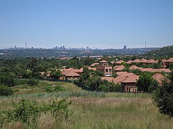
Suburbs
Randburg contains numerous suburbs; many of these are residential. The following is a list of all suburbs that fell under the municipal area of Randburg:
The central business district of Randburg had fallen into decay starting in the 1990s,[19] and plans were made to revive the CBD by the Johannesburg municipality.[20]
Strijdom Park is a well developed commercial/light industrial area in Randburg, wedged between the N1 Western Bypass and Malibongwe Drive. Strijdom park has a substantial auto sales and repair industry and has several other small industries that service the whole of northern Johannesburg.
Randburg has faced competition from Sandton which is normally the preferred location for businesses but offers lower rentals and property prices whilst providing easy transportation to the west and central Johannesburg. There are future plans to connect Randburg onto the Gautrain routes. Cresta Shopping Centre is located in Randburg, as is Northlands Deco Park.[21]
Education
Randburg has many schools within its borders and in the nearby areas.
The Lanseria International Airport, located just outside Randburg is conveniently situated within the greater vicinity of the town, located about 15 kilometres (9.3mi) north-west of the suburb of Northriding. Lanseria mainly handles general aviation traffic however FlySafair currently offers scheduled domestic services to Cape Town and Durban.
There are also a number of metropolitan routes within the Greater Johannesburg metropolitan region that serve Randburg including the M5 (Beyers Naudé Drive) to Johannesburg and Muldersdrift, M6 (John Vorster Road; Ysterhout Drive; Hans Schoeman Street; Hill Street) to Roodepoort, M20 (Republic Road) to Johannesburg and Sandton and the M71 (Bram Fischer Drive) which runs as the main street of the CBD to Sandton.
Pastor Ray McCauley (born 1 October 1949) is the founder of the Rhema Family Church, one of the largest and most influential charismatic churches in South Africa. He established the church in Randburg, where it has grown into a major religious institution with a large congregation and significant impact on the South African Christian community. Pastor McCauley is also known for his involvement in various social and political initiatives, advocating for moral and spiritual values in the public sphere.
Charles Elwes: A distinguished British rower who achieved national prominence as a schoolboy by competing in junior world championships. He won silver in the junior coxed four in 2014 and repeated the feat in the coxless four in 2015. Transitioning to the under-23 level, Elwes secured silver in 2017 and 2018 and gold in 2019. His senior career highlights include a bronze medal at the Tokyo 2020 Olympics, gold at the European Rowing Championships, and victories at the World Rowing Cups. Elwes also won gold at the 2022 World Rowing Championships and followed with another gold in 2023. He further cemented his legacy by winning gold at the 2024 Summer Olympics.
↑"Overview". Johannesburg Development Agency. 2010. Archived from the original on 2012-04-26. Retrieved 2012-04-26.
123Bonner, Philip and Nieftagodien, Noor, Alexandra: A history. Johannesburg: Wits UniversityPress, 2001.
123Maud, John P.R., City government: The Johannesburg experiment. Oxford: Clarendon Press, 1938.
12Carruthers, E.J., ‘The growth of local self-government in the peri-urban areas north of Johannesburg, 1939-1969’. Unpublished MA dissertation, UNISA, 1980.
12Republic of South Africa, Local Government: Municipal Structures Act, 1998 (Act 117 of 1998).
This page is based on this Wikipedia article Text is available under the CC BY-SA 4.0 license; additional terms may apply. Images, videos and audio are available under their respective licenses.