
A road is a linear way for the conveyance of traffic that mostly has an improved surface for use by vehicles and pedestrians. Unlike streets, the main function of roads is transportation.

The Silk Road was a network of Eurasian trade routes active from the second century BCE until the mid-15th century. Spanning over 6,400 kilometers, it played a central role in facilitating economic, cultural, political, and religious interactions between the East and West. The name "Silk Road", first coined in the late 19th century, has fallen into disuse among some modern historians in favor of Silk Routes, on the grounds that it more accurately describes the intricate web of land and sea routes connecting East and Southeast Asia, the Indian subcontinent, Central Asia, the Middle East, East Africa and Europe.

U.S. Route 66 or U.S. Highway 66 was one of the original highways in the United States Numbered Highway System. It was established on November 11, 1926, with road signs erected the following year. The highway, which became one of the most famous roads in the United States, originally ran from Chicago, Illinois, through Missouri, Kansas, Oklahoma, Texas, New Mexico, and Arizona before terminating in Santa Monica in Los Angeles County, California, covering a total of 2,448 miles (3,940 km).

Left-hand traffic (LHT) and right-hand traffic (RHT) are the practices, in bidirectional traffic, of keeping to the left side or to the right side of the road, respectively. They are fundamental to traffic flow, and are sometimes referred to as the rule of the road. The terms right- and left-hand drive refer to the position of the driver and the steering wheel in the vehicle and are, in automobiles, the reverse of the terms right- and left-hand traffic. The rule also extends to where on the road a vehicle is to be driven, if there is room for more than one vehicle in the one direction, as well as the side on which the vehicle in the rear overtakes the one in the front. For example, a driver in an LHT country would typically overtake on the right of the vehicle being overtaken.

The Grand Trunk Road is one of Asia's oldest and longest major roads. For at least 2,500 years it has linked Central Asia to the Indian subcontinent. It runs roughly 2,400 km (1,491 mi) from Teknaf, Bangladesh on the border with Myanmar west to Kabul, Afghanistan, passing through Chittagong and Dhaka in Bangladesh, Kolkata, Prayagraj, Delhi, and Amritsar in India, and Lahore, Gujrat, Rawalpindi, and Peshawar in Pakistan.

Kenilworth Road is an association football stadium in Luton, Bedfordshire, England. It has been the home ground of Luton Town Football Club since 1905. The stadium has also hosted women's and youth international matches, including the second leg of the 1984 European Competition for Women's Football final.
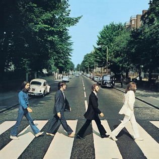
Abbey Road is the eleventh studio album by the English rock band the Beatles. It is the last album the group started recording, although Let It Be was the last album completed and released before the band's break-up in April 1970. It was mostly recorded in April, July and August 1969, and was released on 26 September 1969 in the United Kingdom, and 1 October 1969 in the United States, reaching number one in both countries. A double A-side single from the album, "Something" / "Come Together" was released in October, which also topped the charts in the US.
The area referred to as Fourways is the fastest-developing commercial and residential hub in Sandton, north of Johannesburg, South Africa. The main access routes to Fourways are off the N1 at R511 William Nicol Drive, or alternatively along R564 Witkoppen Road. It is located mostly in Region E of the City of Johannesburg Metropolitan Municipality. It is roughly as far as one can go in the Johannesburg Metropolitan area before it dissolves into rolling hills, game farms and the capital Pretoria, 55 kilometres to the northeast. Hartebeespoort Dam and the Magaliesberg Mountains lie half an hour to the north-west. It is bordered by Bryanston to the east and south and Randburg to the west.

Orkney is a gold mining town situated in the Klerksdorp district of the North West province, South Africa. It lies on the banks of the Vaal River approximately 180 km from Johannesburg near the N12.
Johannesburg North is a suburb of Johannesburg, South Africa. It is located in Region C of the City of Johannesburg Metropolitan Municipality.
Petervale is a suburb of Johannesburg, South Africa. It was located in Region 3 of the City of Johannesburg Metropolitan Municipality.

Mad Max: Fury Road is a 2015 Australian post-apocalyptic action film co-written, co-produced, and directed by George Miller. Miller collaborated with Brendan McCarthy and Nico Lathouris on the screenplay. The fourth instalment in the Mad Max franchise, it was produced by Village Roadshow Pictures, Kennedy Miller Mitchell, and RatPac-Dune Entertainment and distributed by Roadshow Entertainment in Australia and by Warner Bros. Pictures internationally. The film stars Tom Hardy and Charlize Theron, with Nicholas Hoult, Hugh Keays-Byrne, Rosie Huntington-Whiteley, Riley Keough, Zoë Kravitz, Abbey Lee, and Courtney Eaton in supporting roles. Set in a post-apocalyptic desert wasteland where petrol and water are scarce commodities, Fury Road follows Max Rockatansky, who joins forces with Imperator Furiosa against cult leader Immortan Joe and his army, leading to a lengthy road battle.
The R511 is a Regional Route in South Africa that connects Sandton with Thabazimbi via Hartbeespoort and Brits.
The R512 is a Regional Route in South Africa that connects Brits, North West with Randburg, Gauteng via the western side of Hartbeespoort. It is an alternative route to the R511 for travel between the Johannesburg Metropole and Brits.
The R552 is a Regional Route in the City of Johannesburg Metropolitan Municipality in Gauteng, South Africa. It connects Lanseria International Airport with Fourways.

Psychotria capensis, the bird-berry, is a southern African evergreen shrub or small tree. It belongs to a genus which is used medicinally in many regions, 'Psychotria' being from the Greek for 'rejuvenating', in reference to the healing properties of certain species. Kew lists some 2,000 species of Psychotria growing throughout the warmer regions of both hemispheres, but only two of them occur in southern Africa, namely P. capensis and P. zombamontana.

The Belt and Road Initiative, known within China as the One Belt One Road or OBOR for short, is a global infrastructure development strategy adopted by the Chinese government in 2013 to invest in more than 150 countries and international organizations. It is considered a centerpiece of the Chinese leader Xi Jinping's foreign policy. The BRI forms a central component of Xi's "Major Country Diplomacy" strategy, which calls for China to assume a greater leadership role for global affairs in accordance with its rising power and status. It has been compared to the American Marshall Plan. As of January 2023, 151 countries were listed as having signed up to the BRI. The participating countries include almost 75% of the world's population and account for more than half of the world's GDP.
Mary Malahlela-Xakana was the first black woman to register as a medical doctor in South Africa. She was also a founding member of the Young Women’s Christian Association.
The 2016 Johannesburg flood was a natural disaster in South Africa that took place on 9 November 2016. The flooding, which occurred in the area east of Johannesburg, affected both Johannesburg and Ekurhuleni. The storm and flash floods caused significant damage to the township of Alexandra, while the suburb of Buccleuch was declared a disaster area. The flooding was caused by a significant cloud burst from a convective system.
M9 is a major metropolitan route in Johannesburg, South Africa. Passing through the heart of the Witwatersrand, it connects the southern suburbs of Johannesburg via the centre of Johannesburg, with the northern suburbs and business centres of Rosebank and Sandton before ending in the outer northern suburbs.

