
Belgium, officially the Kingdom of Belgium, is a country in Northwestern Europe. The country is bordered by the Netherlands to the north, Germany to the east, Luxembourg to the southeast, France to the southwest, and the North Sea to the northwest. It covers an area of 30,528 km2 (11,787 sq mi) and has a population of more than 11.5 million, making it the 22nd most densely populated country in the world and the 6th most densely populated country in Europe, with a density of 376/km2 (970/sq mi). Belgium is part of an area known as the Low Countries, historically a somewhat larger region than the Benelux group of states, as it also included parts of northern France. The capital and largest city is Brussels; other major cities are Antwerp, Ghent, Charleroi, Liège, Bruges, Namur, and Leuven.
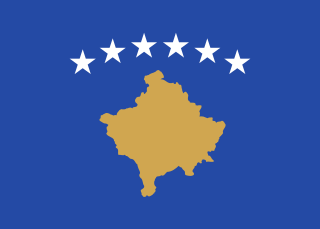
Kosovo, officially the Republic of Kosovo, is a partially recognised state in Southeast Europe. It lies at the centre of the Balkans. Kosovo unilaterally declared its independence from Serbia on 17 February 2008, and has since gained diplomatic recognition as a sovereign state by 101 member states of the United Nations. It is bordered by Serbia to the north and east, North Macedonia to the southeast, Albania to the southwest, and Montenegro to the west. Most of central Kosovo is dominated by the vast plains and fields of Dukagjini and Kosovo field. The Accursed Mountains and Šar Mountains rise in the southwest and southeast, respectively. Its capital and largest city is Pristina.

The Middle East is a geopolitical region commonly encompassing Arabia, Asia Minor, East Thrace, Egypt, Iran, the Levant, Mesopotamia, and the Socotra Archipelago. The term came into widespread usage as a replacement of the term Near East beginning in the early 20th century. The term "Middle East" has led to some confusion over its changing definitions, and has been viewed by some to be discriminatory or too Eurocentric. The region includes the vast majority of the territories included in the closely associated definition of Western Asia, but without the South Caucasus, and additionally includes all of Egypt and all of Turkey.

Punjab is one of the four provinces of Pakistan. Located in central-eastern region of the country, Punjab is the second-largest province of Pakistan by land area and the largest province by population. It shares land borders with the Pakistani provinces of Khyber Pakhtunkhwa to the north-west, Balochistan to the south-west and Sindh to the south, as well as Islamabad Capital Territory to the north-west and Autonomous Territory of AJK to the north. It shares an International border with the Indian states of Rajasthan and Punjab to the east and Indian-administered Kashmir to the north-east. Punjab is the most fertile province of the country as River Indus and its four major tributaries Ravi, Jhelum, Chenab and Sutlej flow through it.

South America is a continent entirely in the Western Hemisphere and mostly in the Southern Hemisphere, with a relatively small portion in the Northern Hemisphere at the northern tip of the continent. It can also be described as the southern subregion of a single continent called America.

Southeast Asia, also spelled South East Asia and South-East Asia, and also known as Southeastern Asia, South-eastern Asia or SEA, is the geographical south-eastern region of Asia, consisting of the regions that are situated south of mainland China, east of the Indian subcontinent, and north-west of mainland Australia. Southeast Asia is bordered to the north by East Asia, to the west by South Asia and the Bay of Bengal, to the east by Oceania and the Pacific Ocean, and to the south by Australia and the Indian Ocean. Apart from the British Indian Ocean Territory and two out of 26 atolls of Maldives in South Asia, Maritime Southeast Asia is the only other subregion of Asia that lies partly within the Southern Hemisphere. Mainland Southeast Asia is completely in the Northern Hemisphere. East Timor and the southern portion of Indonesia are the only parts that are south of the Equator.

ASEAN, officially the Association of Southeast Asian Nations, is a political and economic union of 10 member states in Southeast Asia, which promotes intergovernmental cooperation and facilitates economic, political, security, military, educational, and sociocultural integration between its members and countries in the Asia-Pacific. The union has a total area of 4,522,518 km2 (1,746,154 sq mi) and an estimated total population of about 668 million.

The regions of Italy are the first-level administrative divisions of the Italian Republic, constituting its second NUTS administrative level. There are twenty regions, five of which have higher autonomy than the rest. Under the Constitution of Italy, each region is an autonomous entity with defined powers. With the exception of the Aosta Valley and Friuli-Venezia Giulia, each region is divided into a number of provinces (province).

Western Asia, West Asia, or Southwest Asia, and sometimes incorrectly referred to as the Middle East, is the westernmost subregion of the larger geographical region of Asia, as defined by some academics, UN bodies and other institutions. It is almost entirely a part of the Middle East, and includes Anatolia, the Arabian Peninsula, Iran, Mesopotamia, the Armenian Highlands, the Levant, the island of Cyprus, the Sinai Peninsula, and partly the Caucasus Region (Transcaucasia). The region is considered to be separated from Africa by the Isthmus of Suez in Egypt, and separated from Europe by the waterways of the Turkish Straits and the watershed of the Greater Caucasus. Central Asia lies to its northeast, while South Asia lies to its east. Twelve seas surround the region (clockwise): the Aegean Sea, the Sea of Marmara, the Black Sea, the Caspian Sea, the Persian Gulf, the Gulf of Oman, the Arabian Sea, the Gulf of Aden, the Red Sea, the Gulf of Aqaba, the Gulf of Suez, and the Mediterranean Sea.
A Postal Index Number refers to a six-digit code in the Indian postal code system used by India Post. On 15 August 2022, the PIN system celebrated its 50th anniversary.
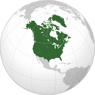
Northern America is the northernmost subregion of North America. The boundaries may be drawn slightly differently. In one definition, it lies directly north of Middle America. Northern America's land frontier with the rest of North America then coincides with the Mexico–United States border. Geopolitically, according to the United Nations' scheme of geographical regions and subregions, Northern America consists of Bermuda, Canada, Greenland, Saint Pierre and Miquelon and the United States.
The Île-de-France is the most populous of the eighteen regions of France. Centred on the capital Paris, it is located in the north-central part of the country and often called the Région parisienne. Île-de-France is densely populated and retains a prime economic position on the national stage: though it covers only 12,012 square kilometres, about 2% of metropolitan French territory, its 2017 population was nearly one-fifth of the national total.

MENA, an acronym in the English language, refers to a grouping of countries situated in and around the Middle East and North Africa. It is also known as WANA, SWANA, or NAWA, which alternatively refers to the Middle East as Western Asia and is a way to refer to the geography instead of the political term.

The National Capital Region (NCR) is a planning region centred upon the National Capital Territory (NCT) of Delhi in India. It encompasses Delhi and several districts surrounding it from the states of Haryana, Uttar Pradesh and Rajasthan. The NCR and the associated National Capital Region Planning Board (NCRPB) were created in 1985 to plan the development of the region and to evolve harmonized policies for the control of land-uses and development of infrastructure in the region. Prominent cities of NCR include Delhi, Faridabad, Ghaziabad, Gurugram, and Noida.

East Asia is the eastern region of Asia, which is defined in both geographical and ethno-cultural terms. The modern states of East Asia include China, Japan, Mongolia, North Korea, South Korea, and Taiwan. China, North Korea, South Korea and Taiwan are all unrecognised by at least one other East Asian state due to severe ongoing political tensions in the region, specifically the division of Korea and the political status of Taiwan. Hong Kong and Macau, two small coastal quasi-dependent territories located in the south of China, are officially highly autonomous but are under Chinese sovereignty. Japan, Taiwan, South Korea, Mainland China, Hong Kong, and Macau are among the world's largest and most prosperous economies. East Asia borders Siberia and the Russian Far East to the north, Southeast Asia to the south, South Asia to the southwest, and Central Asia to the west. To the east is the Pacific Ocean and to the southeast is Micronesia.

New England is a region comprising six states in the Northeastern United States: Connecticut, Maine, Massachusetts, New Hampshire, Rhode Island, and Vermont. It is bordered by the state of New York to the west and by the Canadian provinces of New Brunswick to the northeast and Quebec to the north. The Atlantic Ocean is to the east and southeast, and Long Island Sound is to the southwest. Boston is New England's largest city, as well as the capital of Massachusetts. Greater Boston is the largest metropolitan area, with nearly a third of New England's population; this area includes Worcester, Massachusetts, Manchester, New Hampshire, and Providence, Rhode Island.

South Asia is the southern subregion of Asia, which is defined in both geographical and ethnic-cultural terms. The region consists of the countries of Afghanistan, Bangladesh, Bhutan, India, Maldives, Nepal, Pakistan, and Sri Lanka. Topographically, it is dominated by the Indian subcontinent and defined largely by the Indian Ocean on the south, and the Himalayas, Karakoram, and Pamir mountains on the north. The Amu Darya, which rises north of the Hindu Kush, forms part of the northwestern border. On land (clockwise), South Asia is bounded by Western Asia, Central Asia, East Asia, and Southeast Asia.
Auvergne-Rhône-Alpes is a region in southeast-central France created by the 2014 territorial reform of French regions; it resulted from the merger of Auvergne and Rhône-Alpes. The new region came into effect on 1 January 2016, after the regional elections in December 2015.

Jammu and Kashmir is a region administered by India as a union territory and consists of the southern portion of the larger Kashmir region, which has been the subject of a dispute between India and Pakistan since 1947, and between India and China since 1962. The Line of Control separates Jammu and Kashmir from the Pakistani-administered territories of Azad Kashmir and Gilgit-Baltistan in the west and north. It lies to the north of the Indian states of Himachal Pradesh and Punjab and to the west of Ladakh which is administered by India as a union territory.

