
Sandton is an upscale commercial and residential district north of the city of Johannesburg, South Africa. It forms part of the City of Johannesburg Metropolitan Municipality. The name of the city came from the combination of two of its suburbs, Sandown and Bryanston. In 1969, Sandton was promulgated as a municipality in its own right, but lost its status as an independent city after the re-organisation of South African local governments after Apartheid ended.
The area referred to as Fourways is the fastest-developing commercial and residential hub in Sandton, north of Johannesburg, South Africa. The main access routes to Fourways are off the N1 at R511 William Nicol Drive, or alternatively along R564 Witkoppen Road. It is located mostly in Region E of the City of Johannesburg Metropolitan Municipality. It is roughly as far as one can go in the Johannesburg Metropolitan area before it dissolves into rolling hills, game farms and the capital Pretoria, 55 kilometres to the northeast. Hartebeespoort Dam and the Magaliesberg Mountains lie half an hour to the north-west. It is bordered by Bryanston to the east and south and Randburg to the west.

Rosebank is a cosmopolitan commercial and residential suburb to the north of central Johannesburg, South Africa. It is located in Region B of the City of Johannesburg Metropolitan Municipality, and is the location of a Gautrain station.

Roodepoort is a town in the Gauteng province of South Africa. Formerly an independent municipality, Roodepoort became part of the Johannesburg municipality in the late 1990s, along with Randburg and Sandton. Johannesburg's most famous botanical garden, Witwatersrand National Botanical Gardens, is located in Roodepoort.

The suburbs of Johannesburg are officially demarcated areas within the City of Johannesburg Metropolitan Municipality, South Africa. As in other Commonwealth countries, the term suburb refers to a "neighbourhood", although in South Africa as most "suburbs" have legally recognised borders and often separate postal codes. The municipal functions for the area, such as municipal policing and social services, are still managed by the city government.

Bedfordview is an affluent suburb in western Ekurhuleni, sharing an administrative boundary with the City of Johannesburg Metropolitan Municipality, Gauteng, South Africa. Bedfordview has been part of the City of Ekurhuleni Metropolitan Municipality since 2000. The Eastgate Shopping Centre, one of the biggest in Africa when first built, is also located here.
Auckland Park is a suburb of Johannesburg, South Africa. It lies on a gentle slope, and is in close proximity to the suburbs of Melville, Brixton, Westdene and Richmond. Auckland Park is one of the few suburbs close to the Johannesburg city centre that has remained largely unaffected by the recent migration of Johannesburg residents to the city's northern suburbs. Auckland Park is home to a mix of nationalities and cultures, and the suburb is well known as the location of the South African Broadcasting Corporation headquarters.

Dunkeld is a suburb of Johannesburg, South Africa. It is located in Region 3. It is bordered by the suburbs of Hyde Park and Illovo to the north, Melrose to the east, Rosebank in the south and to the west, Dunkeld West.
Houghton Estate, often simply called Houghton is an affluent suburb of Johannesburg, South Africa, north-east of the city centre.
Kensington is a hilly suburb of Johannesburg, South Africa. It was established in 1897 by Max Langermann. It is located in Region F of the City of Johannesburg Metropolitan Municipality and is bounded to the west by the suburb of Troyeville, to the east by Bedfordview and the north by Bruma and Cyrildene.
Killarney is a suburb of Johannesburg, South Africa. A relatively wealthy area, located west of the M1 freeway, Killarney is a densely built-up area, and it has numerous apartment blocks, as well as a large shopping mall, Killarney Mall.
Melrose includes several suburbs of Johannesburg, South Africa. It is located in Region E of the City of Johannesburg Metropolitan Municipality. Melrose is a developing up-market suburb.
Orange Grove is a suburb of Johannesburg, South Africa. It is located in Region E of the City of Johannesburg Metropolitan Municipality.
Parktown is a wealthy suburb of Johannesburg, South Africa, the first suburb north of the inner city. It is affectionately known as one of the Parks, others including Parkview, Parkwood, Westcliff, Parktown North, Parkhurst and Forest Town. Parktown is one of Johannesburg's largest suburbs, neighbouring Hillbrow, Braamfontein and Milpark to the South; Berea and Houghton to the East; Killarney and Forest Town to the North, and Westcliff, Melville and Richmond to the West. Originally established by the Randlords in the 1890s, Parktown is now home to many businesses, hospitals, schools, churches and restaurants, whilst still maintaining quiet residential areas. It is also home to three of the five campuses of the University of the Witwatersrand including the education campus, medical school and Wits Business School. Parktown is now divided into Parktown and Parktown West with Jan Smuts Avenue forming the dividing line. It is located in Region F of the City of Johannesburg Metropolitan Municipality.
Doornfontein is an inner-city suburb of Johannesburg, South Africa, located to the east of the city centre, Region 8.
Brixton is a predominantly working class suburb of Johannesburg, South Africa. It is the site of the landmark Sentech Tower, and is near the suburbs of Auckland Park and Melville.
Randpark Ridge is an upmarket suburb of Randburg, South Africa. It is located in the Randburg region of the City of Johannesburg. It fell into the town of Randburg during the apartheid era. Developed in the early 1980s and still relatively new, Randpark Ridge is bordered by several other suburbs including Weltevreden Park, Sundowner, Boskruin, Bromhof, Honeydew and Fairland. It is located on the north-west extremity of Johannesburg.
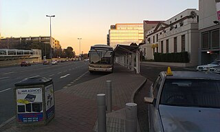
Rosebank is a metro station on the Gautrain rapid transit system in Rosebank, Johannesburg, Gauteng. It opened for passenger services on 2 August 2011 as part of the second phase of the Gautrain project.
Jan Smuts Avenue is a major street in Johannesburg, South Africa. It begins in Randburg, and passes through important business areas like Rosebank. It passes the Johannesburg Zoo, Zoo Lake and Wits University before becoming Bertha Street, and the Nelson Mandela Bridge near the Johannesburg CBD. It has been described as "the most important road for a tourist" in Johannesburg. It forms part of Johannesburg's M27 route.

Barnato Park High School is a co-educational school located in Berea, Johannesburg, South Africa. It was built on the site of the mansion that had been designed for Barney Barnato, the mining millionaire.

