Hillbrow is an inner city residential neighbourhood of Johannesburg, Gauteng Province, South Africa. It is known for its high levels of population density, unemployment, poverty, prostitution and crime.

Randburg is an area located in the Gauteng province of South Africa. Formerly a separate municipality, its administration devolved to the newly created City of Johannesburg Metropolitan Municipality, along with neighbouring Sandton and Roodepoort, in the late 1990s. During the transitional period of 1996–2000, Randburg was part of the Northern Metropolitan Local Council (MLC).

Rosebank is a cosmopolitan commercial and residential suburb to the north of central Johannesburg, South Africa. It is located in Region B of the City of Johannesburg Metropolitan Municipality, and is the location of a Gautrain station.

The suburbs of Johannesburg are officially demarcated areas within the City of Johannesburg Metropolitan Municipality, South Africa. As in other Commonwealth countries, the term suburb refers to a "neighbourhood", although in South Africa most "suburbs" have legally recognised borders and often separate postal codes. The municipal functions for the area, such as municipal policing and social services, are still managed by the city government.
Auckland Park is a suburb of Johannesburg, South Africa. It lies on a gentle slope, and is in close proximity to the suburbs of Melville, Brixton, Westdene and Richmond. Auckland Park is one of the few suburbs close to the Johannesburg city centre that has remained largely unaffected by the recent migration of Johannesburg residents to the city's northern suburbs. Auckland Park is home to a mix of nationalities and cultures, and the suburb is well known as the location of the South African Broadcasting Corporation headquarters.
Park Central is a suburb of Johannesburg, South Africa. It is located in Region F of the City of Johannesburg Metropolitan Municipality.
Regents Park is a suburb of Johannesburg, South Africa. The suburb is found north of The Hill. It is located in Region F of the City of Johannesburg Metropolitan Municipality.
Suideroord is a suburb of Johannesburg, South Africa. It is located in Region F of the City of Johannesburg Metropolitan Municipality.
The Hill is a suburb of Johannesburg, South Africa. The area lies to the south of the Johannesburg CBD and is surrounded by the suburbs of Regents Park, Rosettenville and Linmeyer. It is located in Region F of the City of Johannesburg Metropolitan Municipality.

Glenhazel is a suburb of Johannesburg, South Africa. It is located in Region E, bordering Fairmount, Sandringham, Lyndhurst and Percelia Estate. The area lies on a sloping hill with a park in the valley. It is known for its large Jewish population as well as for being home to the largest Jewish kosher hub in Johannesburg, which attracts many Jewish tourists.
Magaliessig is a suburb of Sandton, South Africa. It is located in Region E of the City of Johannesburg Metropolitan Municipality and it is part of Fourways.
Percelia Estate is a suburb of Johannesburg, South Africa. It is located in Region E of the City of Johannesburg Metropolitan Municipality.
Raumarais Park is a suburb of Johannesburg, South Africa. The suburb lies north of Bramley. It is located in Region E of the City of Johannesburg Metropolitan Municipality.

Groenkloof is a residential suburb of Pretoria, South Africa.
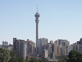
Brixton is a predominantly working class suburb of Johannesburg, South Africa. It is the site of the landmark Sentech Tower, and is near the suburbs of Auckland Park and Melville.
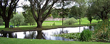
Greenside, is a suburb of Johannesburg, South Africa. Greenside borders on the suburbs Emmarentia, Parkview, Parkhurst and Victory Park.

Rea Vaya is a bus rapid transit system operating in Johannesburg, South Africa. It opened in phases starting on 30 August 2009. Rea Vaya links the Johannesburg CBD and Braamfontein with Soweto. It is currently expanding towards Sandton, Rosebank and Midrand as well. It is one of the first bus rapid transit systems in Africa.
Bezuidenhout Valley is a suburb of Johannesburg, South Africa. The area lies to the east of the Johannesburg CBD and is surrounded by the suburbs of Kensington to the south and Observatory to the north. It is located in Region E of the City of Johannesburg Metropolitan Municipality. It is colloquially known as the Bez Valley.

Westdene is a suburb of Johannesburg, South Africa. Westdene lies between the historic suburb of Sophiatown and Melville with the Melville Koppies nature reserve to the north of the suburb. Westdene derives its name from its location, literally meaning west-valley. 'West' since it is located west from the city centre and with 'dene' derived from the Old English denu, meaning valley.
Wanderers View is a suburb of Johannesburg, South Africa, about 1.2 km north of City Hall.