
The Rouge River is a river in Markham, Pickering, Richmond Hill and Toronto in the Greater Toronto Area of Ontario, Canada. The river flows from the Oak Ridges Moraine to Lake Ontario at the eastern border of Toronto, and is the location of Rouge Park, the only national park in Canada within a municipality. At its southern end, the Rouge River is the boundary between Toronto and southwestern Pickering in the Regional Municipality of Durham.
River Club is a suburb of Johannesburg in Gauteng, South Africa. It is a residentially zoned area near Sandton in Johannesburg's Region E of the City of Johannesburg Metropolitan Municipality. Residents of the area consist mostly of middle and upper-middle class citizens.

The Jukskei River is one of the largest rivers in Johannesburg, South Africa. It is the southernmost river in the Crocodile River (West) basin.
Emmarentia is a suburb of Johannesburg, South Africa.
Greenside, is a suburb of Johannesburg, South Africa. Greenside borders on the suburbs Emmarentia, Parkview, Parkhurst and Victory Park.

The Johannesburg Botanical Garden is located in the suburb of Emmarentia in Johannesburg, South Africa. The gardens grew out of a large rose garden that was established in 1964 and subsequently expanded from 1969 to cover an area of around 125 hectares (1.25 km2). It is administered by Johannesburg City Parks. The Emmarentia Dam is situated immediately to the east of the garden and shares its extensive acreage. One of the main attractions is the Rose Garden with over 10 000 roses.

The Hennops River is one of the larger rivers that drains Gauteng, South Africa. It has its source near Kempton Park, east of Johannesburg and meets the Crocodile River (Limpopo) shortly before Hartbeespoort Dam. It is one of Gauteng's most polluted rivers.

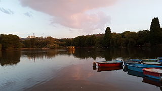
Emmarentia Dam is a dam in Emmarentia, Johannesburg, South Africa. There are several dams that make up Emmarentia Dam, despite its allusion to the singular, with two small dams found upstream in the Johannesburg Botanical Gardens.
Zoo Lake is a popular lake and public park in Johannesburg, South Africa. It is part of the Hermann Eckstein Park and is opposite the Johannesburg Zoo. The Zoo Lake consists of two dams, an upper feeder dam, and a larger lower dam, both constructed in natural marshland watered by the Parktown Spruit.

The Crocodile River is a river in South Africa. At its confluence with the Marico River, the Limpopo River is formed.

The Kraai River is a tributary of the Orange River that flows near Barkly East in the Eastern Cape, South Africa.
Jan Smuts Avenue is a major street in Johannesburg, South Africa. It begins in Randburg, and passes through important business areas like Rosebank. It passes the Johannesburg Zoo, Zoo Lake and Wits University before becoming Bertha Street, and the Nelson Mandela Bridge near the Johannesburg CBD. It has been described as "the most important road for a tourist" in Johannesburg. It forms part of Johannesburg's M27 route.

The Vals River is a tributary of the Vaal River in the Free State, South Africa. It is a strong seasonal river.
The Mooi River is a river in North West Province, South Africa. It is a tributary of the Vaal River and belongs to the Upper Vaal Water Management Area.

Rand Water, previously known as the Rand Water Board, is a South African water utility that supplies potable water to the Gauteng province and other areas of the country and is the largest water utility in Africa. The water is drawn from numerous sources and is purified and supplied to industry, mining and local municipalities and is also involved in sanitation of waste water.

Westdene is a suburb of Johannesburg, South Africa. Westdene lies between the historic suburb of Sophiatown and Melville with the Melville Koppies West nature reserve to the north of the suburb. Westdene derives its name from its location, literally meaning west-valley. 'West' since it is located west from the city centre and with 'dene' derived from the Old English denu, meaning valley.
M27 is a major road in Johannesburg, South Africa. A large part of the route is named Jan Smuts Avenue which is roughly 12 km long. It begins in the southern suburb of Booysens and heads northwards through the Johannesburg CBD and the northern suburbs of Randburg.
M16 is a metropolitan route in Johannesburg, South Africa. It begins in the north-western suburb of Greenside and heads eastwards through some of Johannesburg's northern suburbs and through Edenvale to end at the East Rand town of Kempton Park.
M71 is a major metropolitan route in Johannesburg, South Africa. Starting in the northern CBD, it connects the centre of Johannesburg with the northern suburbs before ending in the outer northern city of Midrand.
The M20 is a short metropolitan route in Johannesburg It connects Randburg in the western part of Johannesburg with Edenvale in the east.

