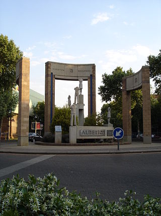
Alberton is a city situated on the southern part of the East Rand of the Gauteng Province in South Africa and is situated very close to the major urban centre of Johannesburg.
Heriotdale is a suburb of Johannesburg, South Africa. The suburb lying south of Malvern and north of Rosherville, is an industrial area. It is located in Region F of the City of Johannesburg Metropolitan Municipality.
Kenilworth is a suburb of Johannesburg, South Africa. The suburb has Turffontein to the west and Rosettenville to the east, with the Turffontein Racecourse on its northern boundary. It is located in Region F of the City of Johannesburg Metropolitan Municipality.
La Rochelle is a suburb of Johannesburg, South Africa. South of the Johannesburg CBD, the suburbs of Turffontein and Rosettenville lie to its south. It is located in Region F of the City of Johannesburg Metropolitan Municipality.
Ophirton is a suburb of Johannesburg, South Africa. This industrial suburb lies three kilometers to south-west of the Johannesburg CBD. It is located in Region F of the City of Johannesburg Metropolitan Municipality.
The Hill is a suburb of Johannesburg, South Africa. The area lies to the south of the Johannesburg CBD and is surrounded by the suburbs of Regents Park, Rosettenville and Linmeyer. It is located in Region F of the City of Johannesburg Metropolitan Municipality.
Theta is a suburb of Johannesburg, South Africa. It lies south-west of the Johannesburg CBD and is adjacent to Booysens Reserve. The suburb was originally developed for science, industrial and research businesses. It is located in Region F of the City of Johannesburg Metropolitan Municipality.
City and Suburban is a suburb of Johannesburg, South Africa, just east of the city centre. It is a relatively small residential and business area, inhabited by 2 703 (99,4%) an overwhelming Black majority, according to the 2011-census. It is located in Region F of the City of Johannesburg Metropolitan Municipality.
Bagleyston is a suburb of Johannesburg, South Africa. It lies north-east of the Johannesburg CBD and is surrounded by Sydenham, Rouxville and Orchards. It is located in Region E of the City of Johannesburg Metropolitan Municipality.
Edenburg is a suburb of Johannesburg, South Africa. It is located in Region E. The name is a source of confusion, as the whole area is known not as Edenburg but as Rivonia. The road from Johannesburg to the south is named Rivonia Road. Edenburg has one large extension, and there are up to 25 small Extensions named 'Rivonia Extension ...' lying to the north. The name change took place many years ago, but was never made official in the Land Register.
Edenburg took its name from the farm by that name.
Fellside is a suburb of Johannesburg, South Africa. It is a small suburb located north-east of the city centre with Orange Grove to its north, south and east, with Houghton Estate to its west. It is located in Region E of the City of Johannesburg Metropolitan Municipality.
Raumarais Park is a suburb of Johannesburg, South Africa. The suburb lies north of Bramley. It is located in Region E of the City of Johannesburg Metropolitan Municipality.
Malvern is a suburb of Johannesburg, South Africa. Situated east of the Johannesburg CBD, it lies south of Kensington and north of the industrial suburb of Denver. It is located in Region F of the City of Johannesburg Metropolitan Municipality and lies just west of Bedfordview in the City of Ekurhuleni Metropolitan Municipality.
Salisbury Claims is a suburb of Johannesburg, South Africa. It is located in Region F of the City of Johannesburg Metropolitan Municipality.
Troyeville is a suburb of Johannesburg, South Africa. It is a small suburb found on the eastern edge of the Johannesburg central business district (CBD), with the suburbs of New Doornfontein, Bertrams and Lorentzville to the north, Fairview to the south and Kensington to its east. The main road through the suburb is Albertina Sisulu, has its eastern end in the suburb and connects the CBD to Johannesburg's eastern suburbs and towns of the East Rand. It is located in Region F of the City of Johannesburg Metropolitan Municipality.
Village Main is a suburb of Johannesburg, South Africa. The suburb lies less than a kilometre south of the Johannesburg CBD. Once mining land, now consists of light industry and one of the city's main freeway, M2 runs through the suburb. It is located in Region F of the City of Johannesburg Metropolitan Municipality.
Emmarentia is a suburb of Johannesburg, South Africa.

The Johannesburg Botanical Garden is located in the suburb of Emmarentia in Johannesburg, South Africa. The gardens grew out of a large rose garden that was established in 1964 and subsequently expanded from 1969 to cover an area of around 125 hectares (1.25 km2). It is administered by Johannesburg City Parks. The Emmarentia Dam is situated immediately to the east of the garden and shares its extensive acreage. One of the main attractions is the Rose Garden with over 10 000 roses.
Linksfield is a suburb of Johannesburg, South Africa. It is a suburb lying north-east of the Johannesburg CBD and is surrounded southerly by Linksfield Ridge, easterly by Linksfield North and Bedford, St Andrews and Senderwood. Linksfield itself is located in Region E of the City of Johannesburg Metropolitan Municipality. On the southerly side and over the ridge are the areas of Cyrildene, Observatory and Morninghill, but these suburbs are not visible to Linksfield as they are hidden behind the Linksfield Ridge.
Bezuidenhout Valley is a suburb of Johannesburg, South Africa. The area lies to the east of the Johannesburg CBD and is surrounded by the suburbs of Kensington to the south and Observatory to the north. It is located in Region E of the City of Johannesburg Metropolitan Municipality. It is colloquially known as the Bez Valley.


