
Randburg is an area located in the Gauteng province of South Africa. Formerly a separate municipality, its administration devolved to the newly created City of Johannesburg Metropolitan Municipality, along with neighbouring Sandton and Roodepoort, in the late 1990s. During the transitional period of 1996–2000, Randburg was part of the Northern Metropolitan Local Council (MLC).
The area referred to as Fourways is the fastest-developing commercial and residential hub in Sandton, north of Johannesburg, South Africa. The main access routes to Fourways are off the N1 at R511 William Nicol Drive, or alternatively along R564 Witkoppen Road. It is located mostly in Region E of the City of Johannesburg Metropolitan Municipality. It is roughly as far as one can go in the Johannesburg Metropolitan area before it dissolves into rolling hills, game farms and the capital Pretoria, 55 kilometres to the northeast. Hartebeespoort Dam and the Magaliesberg Mountains lie half an hour to the north-west. It is bordered by Bryanston to the east and south and Randburg to the west.

Roodepoort is a town in the Gauteng province of South Africa. Formerly an independent municipality, Roodepoort became part of the Johannesburg municipality in the late 1990s, along with Randburg and Sandton. Johannesburg's most famous botanical garden, Witwatersrand National Botanical Gardens, is located in Roodepoort.

The suburbs of Johannesburg are officially demarcated areas within the City of Johannesburg Metropolitan Municipality, South Africa. As in other Commonwealth countries, the term suburb refers to a "neighbourhood", although in South Africa as most "suburbs" have legally recognised borders and often separate postal codes. The municipal functions for the area, such as municipal policing and social services, are still managed by the city government.
Weltevredenpark is a suburb of Roodepoort, South Africa adjacent to Johannesburg. It is situated roughly between Beyers Naudé Drive and Hendrik Potgieter Street.
River Club is a suburb of Johannesburg in Gauteng, South Africa. It is a residentially zoned area near Sandton in Johannesburg's Region E of the City of Johannesburg Metropolitan Municipality. Residents of the area consist mostly of middle and upper-middle class citizens.
Houghton Estate, often simply called Houghton is an affluent suburb of Johannesburg, South Africa, north-east of the city centre.
Randpark is a suburb of the city of Johannesburg, South Africa. It is located in the northern suburbs of the City of Johannesburg.

The City of Johannesburg Metropolitan Municipality is a metropolitan municipality that manages the local governance of Johannesburg, South Africa. It is divided into several branches and departments in order to expedite services for the city. Zulu is the most spoken home language at 23.4% followed by English at 20.1%.

The M3 is an expressway in Cape Town, South Africa, connecting the upper part of the City Bowl to the Southern Suburbs and ending in Tokai. For most of its route it parallels - though further to the south and west - the M4, which was the original road connecting central Cape Town with the settlements to the south.

Constantia Nek is a low pass over the Table Mountain range in Cape Town, South Africa, linking Constantia to Hout Bay in the west. It is one of three passes connecting Hout Bay to the rest of the city, and, with Ou Kaapse Weg is one of the two passes over the mountain range between the city centre and the Fish Hoek valley.

The Crocodile River is a river in South Africa. At its confluence with the Marico River, the Limpopo River is formed.

The Table Mountain Challenge is a 37 km mountain trail run annually clockwise around Table Mountain and Devil's Peak, South Africa and consisting mostly of single track with a few kilometers of jeep track. The trail involves a great amount of scrambling, passing through an indigenous forest and crossing mountain streams, steep slopes of fynbos and views.
Jan Smuts Avenue is a major street in Johannesburg, South Africa. It begins in Randburg, and passes through important business areas like Rosebank. It passes the Johannesburg Zoo, Zoo Lake and Wits University before becoming Bertha Street, and the Nelson Mandela Bridge near the Johannesburg CBD. It has been described as "the most important road for a tourist" in Johannesburg. It forms part of Johannesburg's M27 route.
The R564 is a Regional Route in Gauteng, South Africa. Its entire length is now within the metropolis of Johannesburg, connecting Roodepoort with Buccleuch.
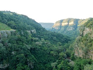
The Krantzkloof Nature Reserve, managed by Ezemvelo KZN Wildlife, conserves 668 ha of the Molweni and Nkutu River gorges that incise the sandstone Kloof plateau in KwaZulu-Natal, South Africa. The reserve conserves coastal scarp forest, sourveld grassland, a cliff face biotope, and aquatic environments along its rivers. Scarp forest is a threatened forest type, protected by South Africa's forests act of 1998, while the grassland is classified as KwaZulu-Natal sandstone sourveld, the most threatened terrestrial habitat in the Durban metropole. The reserve was established in 1950 and was augmented by land donations as late as 1999.

The following outline is provided as an overview of and topical guide to Cape Town:
The M18 is a long metropolitan route in Greater Johannesburg, South Africa. It connects Krugersdorp with Bruma via Constantia Kloof, Florida, Auckland Park, Braamfontein and Observatory.
The M47 is a short metropolitan route in the City of Johannesburg, South Africa It connects the N14 at Cradlestone Mall with the M18 at Maraisburg in Roodepoort. It consists of only one street, named Hendrik Potgieter Road.
The M86 is a short metropolitan route in the Greater Johannesburg, South Africa. It connects Krugersdorp with Randpark Ridge via Roodepoort.

