N12 (South Africa)

Last updated

SA road N12.svg
National route N12
Map of the N12 (South Africa) with labels.svg
Meiringspoort-001.jpg
The N12 at Perseboom Drift in Meiringspoort as it passes through the Swartberg
Route information
Maintained by SANRAL
Length1,342 km (834 mi)
Major junctions
Southwest endSA road N2 jct.svg N2 near George
Major intersectionsSA road N9 jct.svg N9 near George
SA road N1 jct.svg N1 near Beaufort West
SA road N1 jct.svg N1 at Three Sisters
SA road N10 jct.svg N10 at Britstown
SA road N8 jct.svg N8 in Kimberley
SA road N18 jct.svg N18 at Warrenton
SA road N1 jct.svg N1 near Soweto
SA road N3 jct.svgSA road N17 jct.svg N3  / N17 near Germiston
SA road N3 jct.svg N3 at Bedfordview
Northeast endSA road N4 jct.svg N4 in eMalahleni
Location
Country South Africa
Provinces Western Cape, Northern Cape, North West, Gauteng, Mpumalanga
Major cities
Highway system
SA road N11.svg N11 SA road N14.svg N14

The N12 is a national route in South Africa which runs from George through Beaufort West, Kimberley, Klerksdorp and Johannesburg to eMalahleni. [1]

Contents

It is the only other National Route after the N1 route that connects the Western Cape Province with the Gauteng Province. Prior to 1971, the N12 from Johannesburg to Three Sisters was known as the N13. [2] [ citation needed ]

Route

Summary

The road starts in George in the Western Cape and ends in eMalahleni in Mpumalanga. The road runs roughly from south to north, however, once it passes Kimberley in the Northern Cape, it gradually turns eastward. Only the section between Soweto and eMalahleni is a limited access dual motorway. The section between Klerksdorp and Potchefstroom is a dual carriage highway. The N12 remains the only National Route other than the N1 that links Beaufort West with Johannesburg.

Western Cape

The N12 route begins south-east of the town centre of George at an intersection with the N2. From this junction, it runs concurrently with the N9. It goes north-west, through the centre of George. Near Mont Fleur Mountain Estate, the N12/N9 turns northwards, passing through the western area of the Witfontein Nature Reserve as the Outeniqua Pass. [1]

At the junction with the R62 at the northern edge of the Outeniqua Mountains, the N12 splits from the N9 and becomes cosigned with the R62, going north-west towards Oudtshoorn (33 km). In Oudtshoorn, at the four-way intersection with the R328, the R62 continues by way of a left turn and the N12 continues by way of a right turn. The N12 goes east-north-east for 35 km, bypassing Dysselsdorp, to reach De Rust, where it meets the R341 route. At this point, it turns northwards, becoming the Meiringspoort Pass, passing the Swartberg mountain range. After Meiringspoort, at Klaarstroom, the N12 cosigns with the R407 for a few kilometres westwards up to the next junction, where the R407 continues westwards and the N12 continues northwards. The N12 makes a 120 km journey to Beaufort West. [1]

Just before Beaufort West, at the south-eastern edge of the Karoo National Park, the N12 meets the N1 national route and joins it. They are one route through Beaufort West, meeting the western terminus of the R61. The N1 and N12 routes remain as one road for the next 75 km north-east from Beaufort West to Three Sisters, where they enter the Northern Cape. [1]

Northern Cape

At Three Sisters, the N12/N1 enter the Northern Cape. At the next junction, the N12 and the N1 split, with the N1 continuing to Colesberg and the N12 becoming the road northwards. The N12 and the N1 meet again later, in Johannesburg South, Gauteng. The N12 is the only national route other than the N1 that links the Western Cape with Johannesburg, with the N12 passing through Kimberley and the N1 passing through Bloemfontein. [1] While the N1 is a toll road from Bloemfontein onwards, the N12 is toll-free from Three Sisters to Johannesburg South. [1]

From the Three Sisters split, the N12 makes a 170 km northwards journey, through Victoria West (where it meets the R63), to Britstown, where passes through the town centre before meeting the N10 national route coming from De Aar. The two routes cosign for 3 km northwards before the N10 makes its own way north-west towards Upington and Namibia. [1]

The N12 continues north-north-east for 254 km, through Strydenburg and Hopetown (where it crosses the Orange River), to Kimberley (capital city of the Northern Cape). It enters as Memorial Road, meeting the south-eastern terminus of the R31 road before meeting the N8 national route (which is coming from Bloemfontein) and co-signing with it northwards as Bultfontein Road. At the Long Street junction in the city centre, the N8 becomes Long Street westwards and the N12 becomes the road eastwards. Just after, the N12 meets the western terminus of the R64 road (which is also coming from Bloemfontein) and becomes the road northwards (Quinn Street). [1]

From Hopetown, the N12 gradually follows the shape of the border between the Northern Cape and the Free State, as well as the border between the North West and the Free State. (Following in close proximity; switching from going northwards to going eastwards without touching the border)

From Kimberley, the N12 makes a 75 km journey northwards to Warrenton, where it meets the southern terminus of the N18 national route and crosses the Vaal River. [1]

North West

Just after Warrenton, the N12 enters the North West. It makes a 100 km journey north-east, following the Vaal River, through Christiana, to Bloemhof, where it meets the R34 road (co-signed for 2 kilometres) and passes through as Prince Street. [1]

From Bloemhof, the N12 continues north-east for 150 km, passed Wolmaransstad, to Klerksdorp, where it becomes a freeway (dual carriageway highway) and meets the R30 road. It continues eastwards as a freeway for another 50 km to Potchefstroom, an academic city (where it meets the R53 route in the city centre next to the Mooi River crossing and the western terminus of the R54 route about 9 kilometres after the city centre). [1]

Gauteng

After Potchefstroom, the N12 enters Gauteng eastwards and bypasses the towns of Carletonville (in the Merafong City Local Municipality), Westonaria (in the Rand West City Local Municipality; where it meets the R28 road) and Lenasia as the Moroka Bypass into the City of Johannesburg Metropolitan Municipality. At the R558 junction, the N12 becomes a freeway and separates Soweto in the north from Lenasia in the south. The N12 proceeds eastwards to meet the N1 national route again (north eastbound only) at the Misgund Interchange adjacent to the Olifantsvlei Nature Reserve. [1]

The N12 joins the N1 and they become one freeway northwards for four kilometres, meeting the R553 Golden Highway, up to the Diepkloof Interchange, the south-western corner of the Johannesburg Ring Road. [1]

Northbound road sign at the R553 Golden Highway off-ramp before the Diepkloof Interchange Joburgsign1844.JPG
Northbound road sign at the R553 Golden Highway off-ramp before the Diepkloof Interchange

As the N1 continues north through the western area of Johannesburg's municipality as the N1 Western Bypass, the N12 becomes the highway going eastwards through the southern area of Johannesburg as the N12 Southern Bypass. Here, the N12 Southern Bypass, which cuts a concrete swath through the rocky hills of southern Johannesburg, is apparently very reminiscent of the freeways of Los Angeles, and together with Johannesburg's sunshine, renders a real Southern California feel to that part of the city. [1]

Just after splitting from the N1, north of Southgate Shopping Centre and south of the Aeroton industrial area, at the Uncle Charlie's Interchange, the N12 meets the M1 De Villiers Graaff Motorway (north eastbound only), which is the freeway to Johannesburg Central and Sandton in the north. The N12 highway continues eastwards, through many suburbs of Johannesburg South (including Ridgeway, Winchester Hills and Oakdene), to Alberton. At the Reading interchange with the R59 Sybrand van Niekerk Freeway in Alberton, the N12 begins to change direction, slowly turning northwards. The next off-ramp with the M31/R103 provides access to Alberton Central. [1]

The N12 freeway eastbound near Alberton Road near alberton.jpg
The N12 freeway eastbound near Alberton

At the Elands Interchange, the N12 flies over the N17 toll freeway and merges with the N3 freeway from Heidelberg and Durban to form the N3 Eastern Bypass portion of the Johannesburg Ring Road, going northwards. [1] At the Elands Interchange, as part of the Gauteng Freeway Improvement Scheme, two slip roads have been made linking the N17 toll freeway to the N12 freeway. It is now possible to travel from the N17 west to the N12 west and from the N12 east to the N17 east (previously only possible via the N3). [3]

While cosigned with the N3 northwards, they are one road, bypassing Germiston (Capital of Ekurhuleni) to the west and intersecting with the M2 freeway at the Geldenhuys Interchange, where the M2 provides access to Germiston Central in the east and Johannesburg Central in the west. [1]

The N3/N12 continue northwards up to the George Bizos Interchange (previously known as the Gillooly's Interchange [4] ) in Bedfordview, east of the Eastgate Shopping Centre. At this interchange, the N12 leaves the Eastern Bypass portion of the Johannesburg Ring Road (which remains designated as the N3 northwards) and joins the R24 Airport Freeway eastwards. [1] Due to common traffic at this interchange, it is purported to be the busiest interchange in the Southern Hemisphere. [5]

The N12 is cosigned with the R24 for 2 kilometers. Just before the Lungile Mtshali Road off-ramp, the R24 and the N12 split, with the R24 becoming its own east-north-east freeway (the Albertina Sisulu Freeway) towards O. R. Tambo International Airport (Johannesburg International Airport) and the N12 remaining as the eastwards highway towards Benoni and Witbank. [1]

The N12 continues through the City of Ekurhuleni Metropolitan Municipality, bypassing Germiston and Boksburg to the north. North of Boksburg, the N12 meets the R21 freeway from Pretoria and O. R. Tambo International Airport in the north (providing access to Boksburg Central in the south). It continues east as the road separating Benoni Central from Benoni's northern suburbs (where it meets the R23 north of the town centre). [1]

It continues eastwards, bypassing Daveyton (where it meets the R51) and Etwatwa, to leave the City of Ekurhuleni Metropolitan Municipality and enter the Mpumalanga Province. [1]

Mpumalanga

In Mpumalanga, the N12 continues as a dual carriageway freeway and the first town it bypasses is the town of Delmas. From the R50 Delmas exit, the N12 goes for another 60 km east, meeting the R42 and bypassing Ogies, to eMalahleni (Witbank). [1]

The N12 marks its end at the point where it merges with the N4 highway (Maputo Corridor) (eastbound only) in the eastern part of Witbank. [1]

History

e-tolls in Gauteng

A portion of the freeway section of the N12 in the Greater Johannesburg Area, from the R553 Golden Highway off-ramp in-between the Misgund and Diepkloof interchanges to the R51 road off-ramp in Daveyton, was effectively declared an e-toll highway (with open road tolling) from 3 December 2013 onwards. [6]

The South African government announced on 28 March 2024 [7] that e-tolls in Gauteng would officially be shut down on 11 April 2024 at midnight. [8] [9] As a result of the e-toll discontinuation, the N12 route is now a toll-free route.

Trans-African Highway Network

The N18 road from the Botswana Border, passing through Mahikeng and Vryburg of the North West Province to Warrenton, together with the N12 to Beaufort West and the N1 road to Cape Town in the Western Cape are collectively declared part of Trans African Highway no. 4 (Cairo-Cape Town Highway). The N12 between Three Sisters and Warrenton is very important as it is part of the Trans-African Highway Network number 4 Extension between Gaborone and Cape Town.

Meiringspoort Pass

The Meiringspoort section in the Swartberg between De Rust and Klaarstroom follows the gorge cut by the Groot River. It is a scenic drive crossing twelve old drifts (replaced by bridges today). From De Rust one will cross the drifts in the following order: Spook drift, Boesman drift, Nooiensboom drift, Dubble Drif se Draai, Ou tol drift, Wa drift, Witfontein se drift, Ontploffings drift, Perskeboom drift, Wasgat drift, Eerste/Laaste drift. [10] [11]

Monuments

Related Research Articles

<span class="mw-page-title-main">N3 (South Africa)</span> National road in South Africa

The N3 is a national route in South Africa that connects Johannesburg and Durban, respectively South Africa's largest and third-largest cities. Johannesburg is the financial and commercial heartland of South Africa, while Durban is South Africa's key port and one of the busiest ports in the Southern Hemisphere and is also a holiday destination. Durban is the port through which Johannesburg imports and exports most of its goods. As a result, the N3 is a very busy highway and has a high volume of traffic.

<span class="mw-page-title-main">Johannesburg Ring Road</span> Ring Road in South Africa

The Johannesburg Ring Road is a set of freeways that circle the city of Johannesburg, South Africa and service the City of Johannesburg Metropolitan Municipality. The entire ring road is approximately 83 km long and was an e-toll highway from 3 December 2013 up until e-tolls were shut down in Gauteng on 12 April 2024.

The Pretoria Ring Road, also known as the Pretoria Bypass, is a collection of two bypasses that together form a partial ring road around the city of Pretoria, South Africa. It consists of a section of the N1 highway as well as a section of the N4 highway. It is entirely in the City of Tshwane Metropolitan Municipality.

<span class="mw-page-title-main">N3 Eastern Bypass (Johannesburg)</span> Road in South Africa

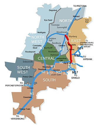
The N3 Eastern Bypass is a section of the Johannesburg Ring Road that forms a beltway around the city of Johannesburg, South Africa, as part of the N3. The first section of the freeway opened in 1971, from Buccleuch to the interchange with Main Reef Road in Germiston. This is one reason why Germiston is listed as the southbound destination of this route, from the Buccleuch to Geldenhuys Interchanges, rather than to the Elands Interchange south of Germiston. The remaining section from Main Reed Road to Black Reef Road, which included the construction of the Geldenhuys Interchange, was opened in 1977, linking the Eastern Bypass with the N3 freeway to Heidelberg. The interchange at Main Reef Road was removed.

<span class="mw-page-title-main">N1 Western Bypass (Johannesburg)</span> Road in South Africa

The Western Bypass is a section of the N1 and the Johannesburg Ring Road located in the city of Johannesburg, South Africa. Known at the time as the Concrete Highway, the freeway was initially opened in 1975 as a route to avoid the city centre of Johannesburg and to provide access to the western areas of the Witwatersrand. From the south, the Western Bypass begins at the Diepkloof Interchange in Soweto, where it splits from the N12 freeway and ends at the Buccleuch Interchange, where it merges with the N3 Eastern Bypass, M1 South and N1 Ben Schoeman freeways.

<span class="mw-page-title-main">N12 Southern Bypass (Johannesburg)</span> Road in South Africa

The N12 Southern Bypass is a section of the Johannesburg Ring Road that forms a beltway around the city of Johannesburg, South Africa, as part of the N12. The freeway was the last section of the Ring Road to be built, with the final section opening in 1986. As part of the old South African Freeways, It was initially called the N13. The entire Southern Bypass freeway was an e-toll highway from 3 December 2013 to 11 April 2024.

<span class="mw-page-title-main">N1 (South Africa)</span> National road in South Africa

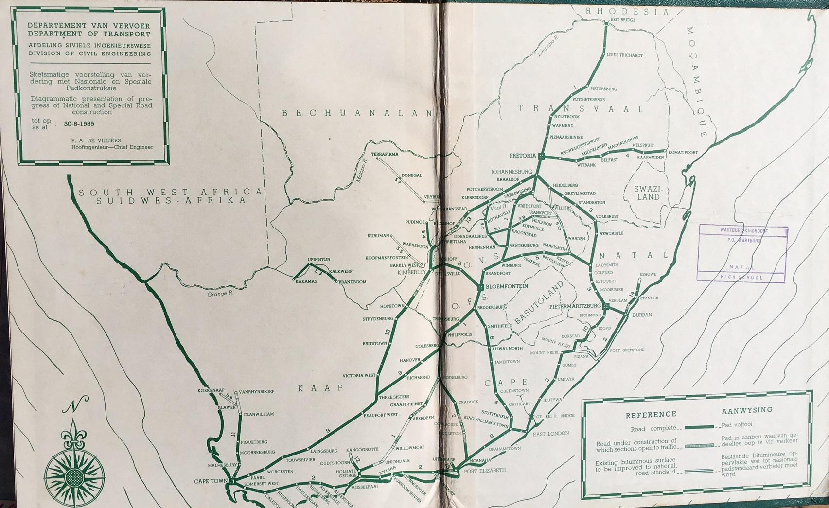
The N1 is a national route in South Africa that runs from Cape Town through Bloemfontein, Johannesburg, Pretoria and Polokwane to Beit Bridge on the border with Zimbabwe. It forms the first section of the famed Cape to Cairo Road.

<span class="mw-page-title-main">R21 (South Africa)</span> Road in South Africa

The R21 is a major north–south provincial route in eastern Gauteng Province, South Africa. Built in the early 1970s, it remains one of two freeways linking Pretoria with Johannesburg, via the R24. As the eastern of the two freeways, it links the Pretoria city centre with OR Tambo International Airport and Boksburg. Between the Solomon Mahlangu Drive on-ramp in Monument Park, Pretoria, and the N12 interchange in Boksburg, the R21 is an 8 lane highway and motorway (freeway), with 4 lanes in each direction. It has off-ramps leading to Irene, Olifantsfontein, Benoni, and Kempton Park. The route intersects the N1 highway near Centurion, the R24 near the airport, the N12 and N17 in Boksburg, and the N3 near Vosloorus on the East Rand, where it ends. The section from the N12 to the N3 is not a freeway. The R21 is also designated as the P157.

<span class="mw-page-title-main">R24 (South Africa)</span> Road in South Africa

The R24 is a major East-West provincial route in the Gauteng and North West provinces that links OR Tambo International Airport with Rustenburg via Johannesburg, Krugersdorp and Magaliesburg. The process of renaming the streets and freeway that form the route from Krugersdorp eastward to OR Tambo International after anti-apartheid stalwart Albertina Sisulu was completed in 2013.

<span class="mw-page-title-main">R28 (South Africa)</span>

The R28 is a provincial route in Gauteng, South Africa that connects Krugersdorp with Vereeniging via Randfontein. The R28 used to connect with Pretoria, but that section of the road is now part of the N14.

<span class="mw-page-title-main">R34 (South Africa)</span> Road in South Africa

The R34 is a long provincial route in South Africa that connects Vryburg with Richards Bay via Kroonstad and Newcastle. It passes through three provinces, North West, the Free State and KwaZulu-Natal.

<span class="mw-page-title-main">R54 (South Africa)</span>

The R54 is a provincial route in South Africa that connects Potchefstroom with Villiers via Vereeniging.

<span class="mw-page-title-main">R59 (South Africa)</span> Road in South Africa

The R59 is a provincial route in South Africa that connects Hertzogville with Alberton via Bothaville, Parys and Vereeniging. The R59 is a freeway from the R57 Junction in Sasolburg until the N12 Reading Interchange in Alberton, signposted as the Sybrand van Niekerk Freeway.

<span class="mw-page-title-main">R82 (South Africa)</span> Road in South Africa

The R82 is a provincial route in South Africa that connects Johannesburg with Kroonstad via Vereeniging and Sasolburg. It starts just south of the M1 Johannesburg Municipal Highway's interchange with the N12 Southern Bypass, going south, meeting the R59, R54, R42 & R28 routes at Vereeniging before crossing the Vaal River into the Free State & proceeding to Kroonstad. It is an alternative, but longer route to the N1 National Route between Johannesburg & Kroonstad.

The M1 De Villiers Graaff motorway is a metropolitan route and major freeway in the City of Johannesburg, South Africa. The highway connects the southern areas with the city centre and extends further north through Sandton into the Ben Schoeman Highway towards Pretoria. Construction began in 1962 and resulted in the demolition of many properties and houses including numerous historical Parktown Mansions.

The M2 is a major highway and metropolitan route in Greater Johannesburg, South Africa. It is named the Francois Oberholzer Freeway. It runs just to the south of the Johannesburg Central Business District eastwards where it connects with the N3 and enters Germiston, ending near its CBD. The north–south M1 intersects with the M2 just to the south-west of the Johannesburg CBD.

<span class="mw-page-title-main">N4 (South Africa)</span> National road in South Africa

The N4 is a national route in South Africa that runs from Skilpadshek on the Botswana border, past Rustenburg, Pretoria, eMalahleni and Mbombela, to Komatipoort on the Mozambique border. The entire route is a toll road.

<span class="mw-page-title-main">N14 (South Africa)</span> National road in South Africa

The N14 is a national route in South Africa which runs from Springbok in the Northern Cape to Pretoria in Gauteng. It passes through Upington, Kuruman, Vryburg, Krugersdorp and Centurion. The section between Pretoria and Krugersdorp is maintained by the Gauteng Provincial government and is also designated the P158.

<span class="mw-page-title-main">N17 (South Africa)</span> National road in South Africa

The N17 is a national route in South Africa which runs from Johannesburg to Oshoek (Ngwenya) on the border with Eswatini. It passes through Springs, Bethal and Ermelo.

<span class="mw-page-title-main">Ben Schoeman Freeway</span> Road in South Africa

The Ben Schoeman Freeway or Ben Schoeman Highway is the main freeway between Johannesburg and Pretoria, and consists of portions of the M1, N1, and N14. Opened in 1968, it is named after former Minister of Transport Ben Schoeman, and is undoubtedly the busiest road in South Africa.

References

  1. 1 2 3 4 5 6 7 8 9 10 11 12 13 14 15 16 17 18 19 20 21 22 23 Falkner, John (May 2012). South African Numbered Route Description and Destination Analysis (Report). National Department of Transport. pp. 27–30. Archived from the original on 6 June 2014. Retrieved 12 August 2014.
  2. "Department of Transport Map South Africa".
  3. "Gauteng Freeway Improvement Project : Package E - Sustainable Concrete Commendation | GFIP : Fulton Awards | IMIESA".
  4. "Here are the streets affected by Ekurhuleni's new name changes". The Citizen. 13 October 2021. Retrieved 2 January 2022.
  5. "Busiest freeways in southern hemisphere". SA National Roads Agency. 26 September 2008. Archived from the original on 16 June 2013. Retrieved 15 July 2013.
  6. "E-tolls going live in Gauteng". fin24.com. 20 November 2013. Retrieved 22 August 2014.
  7. Fraser, Luke (28 March 2024). "E-tolls to officially end next month". BusinessTech. Retrieved 12 April 2024.
  8. South African Government ends e-tolls in Gauteng press release published 28th of March 2024, retrieved and archived 5th of April 2024
  9. Njilo, Nonkululeko (10 April 2024). "Gauteng set to finally end e-tolls, overdue fees remain". Daily Maverick. Retrieved 12 April 2024.
  10. G. Ross: Romance of Cape Mountain Passes. New Africa Books. 2004. ISBN   0864866631, 9780864866639. p.89.
  11. "Meiringspoort". samountainpasses.co.za.
  12. "Herrie's Stone, Meiringspoort, Oudtshoorn District - 9/2/068/0010". South African Heritage Resource Agency. Archived from the original on 4 March 2016.