Meiringspoort

Last updated
Meiringspoort
Meiring's pass
RoadThroughMeiringspoort.jpg
View of the road, on the Meiringspoort pass
Location N12 national road, where it crosses the Swartberg mountain range
Coordinates 33°24′59″S22°32′59″E / 33.4163°S 22.5497°E / -33.4163; 22.5497
South Africa relief location map.svg
Red pog.svg
Meiringspoort

Meiringspoort (Afrikaans for "Meiring's pass") is a South African mountain pass on the N12 national road, where it crosses the Swartberg mountain range.

Contents

Geography

The pass is a gateway that connects the Little Karoo and the Great Karoo, through a gorge with a 25 km road crossing the same river 25 times in the span of the 25 km.

It runs between the modern town of Klaarstroom in the north, and the town of De Rust in the south. The mountains it crosses are those of the Swartberg range (Afrikaans for black mountain).

The Swartberg is amongst the best exposed fold mountain chains in the world, and the pass slices through magnificently scenic geological formations. The Swartberg chain runs roughly east–west along the northern edge of the semi-arid area called the Little Karoo in the Western Cape province of South Africa. To the north of the range lies the large semi-arid hinterland of South Africa, the Great Karoo. Much of the Swartberg is part of a UNESCO World Heritage Site. [1]

The over 2000 m high Greater Swartberg range in the distance, viewed from farmlands near the town of Oudtshoorn in the relatively well-watered south. Swartberg01.jpg
The over 2000 m high Greater Swartberg range in the distance, viewed from farmlands near the town of Oudtshoorn in the relatively well-watered south.

History

Early crossings

The Great Swartberg mountain range, seen from the south in stormy weather. Swartberg.jpg
The Great Swartberg mountain range, seen from the south in stormy weather.

The vast Great Swartberg mountain range formed an almost impenetrable barrier for much of the subcontinent's history - separating the Little Karoo in the south, from the Great Karoo of the arid southern African hinterland. The indigenous Khoi-San people had long inhabited the valleys on both sides of the range, and undoubtedly made successful crossings of these mountains. However these journeys were unfortunately not recorded.

In 1800, a farmer from De Rust in the south made the first successful recorded crossing of this point of the range. His name, Petrus Johannes Meiring, was later commemorated in the name of the pass. Eventually, using the river's low point, he and Gerome Marincowitz, another farmer from the north of the range, even opened up a tiny bridle path, along the "Groote Stroom", which enabled the most intrepid travellers to journey through the mountains. In the coming years, Meiring was extremely active in building the campaign for a pass across the Swartberg.

The route

View of the Swartberg Mountain barrier from Klaarstroom in the arid north Klaarstroom sneeu.jpg
View of the Swartberg Mountain barrier from Klaarstroom in the arid north
The great road engineer Thomas Charles John Bain Thomas Bain00.jpg
The great road engineer Thomas Charles John Bain
View of a portion of the pass Meiringspoort between de Rust and Klaarstroom. First road was built between 1856 and 1858. 06.jpg
View of a portion of the pass
The Herrieklip, Meiringspoort Herrie's Stone Meiringspoort 1.JPG
The Herrieklip, Meiringspoort

The pass itself had its origins in a series of petitions from the local people on both sides of the mountains, and in the Molteno report, which ordered the pass's construction in response. John Molteno was an Italian immigrant farmer, who had just been elected to represent much of the Great Karoo region in the new Cape Parliament. In August 1854 he set off on horseback from the village of Beaufort West, together with the two great road engineers Thomas and Andrew Geddes Bain and a friend, Charles Pritchard. After several days journey the four riders reached the Swartberg, and they then spent considerable time exploring the valleys and mountains of the range. Among other routes, they made a crossing along the route that the current road follows.

The Bains favoured a more eastern pass through the Swartberg, along the slopes they had explored in the Toorwater Poort. It was an easier, more efficient crossing to construct for engineering purposes, however it was 50 km east, which would have meant an extra 4 or 5 days travel for every journey across the mountains. Molteno's report therefore chose the route of the current pass. It created a select committee in 1856, which allocated funds, led to the surveying of the chosen route, and the employment of a team of paid labourers (not convict labour as was common at the time). The report envisioned the pass as a means of connecting the underdeveloped Karoo hinterland with the port at Mossel Bay, thereby stimulating exports from the hinterland and the overall Karoo economy. [2] [3]

Construction

The initial allocated budget of £5,000 was at the time considered vastly insufficient, but in the end the project costed only slightly more, at £5,018. The likely possibility of frequent flood damage to the completed road in the ensuing years also needed to be considered.

Construction commenced in August 1856, supervised by Adam de Schmidt, and under the overall management of the Bains. It was on this project that Andrew Geddes Bain developed his revolutionary technique for breaking up and cutting through large boulders. The first stage of building required the clearing of vegetation. He discovered that piling the recently cleared vegetation onto the rock and burning it caused the necessary heat to split the rock up. This was helped further by pouring cold water on the heated rock afterwards. The technique meant that blasting became rarely necessary.

The pass was also the first major project of the young Thomas Bain. Once commenced, the entire 16 km pass was completed in only 223 days of work, opening on 3 March 1858.

A procession of 50 carts, 12 wagons and 300 horsemen crossed it for the opening, and Andrew Bain suggested the name of "Meiring" for the pass, in honour of the farmer, Petrus Meiring. [4] [5]

Effects

Mossel Bay, the intended port and harbour for the Karoo hinterland The National Archives UK - CO 1069-214-127.jpg
Mossel Bay, the intended port and harbour for the Karoo hinterland

The initial report had conceived of the pass as a way of connecting farmers and businesses in the southern African hinterland, with the port at Mossel Bay.

A measure of its success was that Mossel Bay's port structures had to be expanded almost immediately, to cope with the massive growth in exports. By the 1870s, in spite of the frequent repairs from flood damage, one eighth of the country's entire export wool produce was being transported through the pass.

Herrieklip

The "Herrieklip" (Herrie Stone) in Meiringspoort is a stone approximately 15 km from the southern entrance to the gorge where the poet C.J. Langenhoven carved the name "Herrie" into the sandstone in 1929. Herrie was a fictional circus elephant in Langenhoven's satirical works "Sonde met die bure" (Trouble with the neighbours, 1921) and "Herrie op die ou tremspoor" (Herrie on the old tram track, 1925). The stone was declared a national monument in 1973.

Related Research Articles

<span class="mw-page-title-main">Geography of South Africa</span>

South Africa occupies the southern tip of Africa, its coastline stretching more than 2,850 kilometres from the desert border with Namibia on the Atlantic (western) coast southwards around the tip of Africa and then northeast to the border with Mozambique on the Indian Ocean. The low-lying coastal zone is narrow for much of that distance, soon giving way to a mountainous escarpment that separates the coast from the high inland plateau. In some places, notably the province of KwaZulu-Natal in the east, a greater distance separates the coast from the escarpment. Although much of the country is classified as semi-arid, it has considerable variation in climate as well as topography. The total land area is 1,220,813 km2 (471,359 sq mi). It has the 23rd largest Exclusive Economic Zone of 1,535,538 km2 (592,875 sq mi).

<span class="mw-page-title-main">Andrew Geddes Bain</span>

Andrew Geddes Bain, was a South African geologist, road engineer, palaeontologist and explorer.

<span class="mw-page-title-main">Western Cape</span> Province of South Africa on the south-western coast

The Western Cape is a province of South Africa, situated on the south-western coast of the country. It is the fourth largest of the nine provinces with an area of 129,449 square kilometres (49,981 sq mi), and the third most populous, with an estimated 7 million inhabitants in 2020. About two-thirds of these inhabitants live in the metropolitan area of Cape Town, which is also the provincial capital. The Western Cape was created in 1994 from part of the former Cape Province. The two largest cities are Cape Town and George.

<span class="mw-page-title-main">Karoo</span> Semi-desert region in South Africa

The Karoo is a semi-desert natural region of South Africa. No exact definition of what constitutes the Karoo is available, so its extent is also not precisely defined. The Karoo is partly defined by its topography, geology and climate, and above all, its low rainfall, arid air, cloudless skies, and extremes of heat and cold. The Karoo also hosted a well-preserved ecosystem hundreds of million years ago which is now represented by many fossils.

<span class="mw-page-title-main">Garden Route</span>

The Garden Route is a 300-kilometre (190 mi) stretch of the south-eastern coast of South Africa which extends from Witsand in the Western Cape to the border of Tsitsikamma Storms River in the Eastern Cape. The name comes from the verdant and ecologically diverse vegetation encountered here and the numerous estuaries and lakes dotted along the coast. It includes towns such as Witsand, Heidelberg, Riversdale, Stilbaai, Albertinia, Gouritsmond, Knysna, Plettenberg Bay, Mossel Bay, Oudtshoorn, Great Brak River, Little Brak River, Wilderness, Sedgefield and Nature's Valley; with George, the Garden Route's largest city and main administrative centre.

<span class="mw-page-title-main">Swartberg</span> Mountain range in Western Cape, South Africa

The Swartberg mountains are a mountain range in the Western Cape province of South Africa. It is composed of two main mountain chains running roughly east–west along the northern edge of the semi-arid Little Karoo. To the north of the range lies the other large semi-arid area in South Africa, the Great Karoo. Most of the Swartberg Mountains are above 2000 m high, making them the tallest mountains in the Western Cape. It is also one of the longest, spanning some 230 km from south of Laingsburg in the west to between Willowmore and Uniondale in the east. Geologically, these mountains are part of the Cape Fold Belt.

<span class="mw-page-title-main">Nelspoort</span> Place in Western Cape, South Africa

Nelspoort is a town located in Beaufort West Local Municipality in the Western Cape, South Africa.

<span class="mw-page-title-main">Laingsburg, South Africa</span> Place in Western Cape, South Africa

Laingsburg is a town located in the Western Cape province in South Africa. It is a relatively large agricultural town in the semi-arid Great Karoo. It was partially destroyed in a flash flood in 1981.

<span class="mw-page-title-main">N12 (South Africa)</span> National road in South Africa

The N12 is a national route in South Africa which runs from George through Beaufort West, Kimberley, Klerksdorp and Johannesburg to eMalahleni.

<span class="mw-page-title-main">De Rust</span> Place in Western Cape, South Africa

De Rust is a small village at the gateway to the Klein Karoo, South Africa. The name is Dutch and literally translates to "The Rest", referring to the town's original purpose of being a resting place for settlers en route through the challenging terrain of a nearby Swartberg gorge.

<span class="mw-page-title-main">R62 (South Africa)</span> Road in South Africa

The R62 is a provincial route in South Africa that connects Ashton with Humansdorp. The R62 runs through the Little Karoo and the Langkloof, passing through Montagu, Ladismith, Calitzdorp, Oudtshoorn, and Joubertina.

<span class="mw-page-title-main">Swartberg Pass</span>

The Swartberg Pass on the R328 runs over the Swartberg mountain range which runs roughly east–west along the northern edge of the semi-arid area called the Little Karoo in the Western Cape province of South Africa. It's the only road access to Gamkaskloof.

<span class="mw-page-title-main">Thomas Charles John Bain</span>

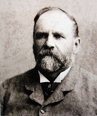
Thomas Charles John Bain was a South African road engineer. As a prolific road building pioneer, Bain was responsible for the planning and construction of more than 900 km of roads and mountain passes, many of them still in use today, over a career spanning from 1848 until 1888. These passes through the mountain ranges between the thin coastal plain and the interior of the former Cape Colony in South Africa, played a major role in opening up the vast hinterland of South Africa.

<span class="mw-page-title-main">Molteno Pass</span>

Molteno Pass is a mountain pass in the Western Cape province of South Africa.

<span class="mw-page-title-main">Touws River (town)</span> Place in Western Cape, South Africa

Touws River is a small railway town of 8,126 people in the Western Cape province of South Africa. It is located on the river of the same name, about 160 kilometres (100 mi) north-east of Cape Town. The Touwsrivier CPV Solar Project is located just outside of the town and supplies 50 MW to the national electrical grid.

Prince Albert Road is a village located in Laingsburg Local Municipality, Western Cape.

<span class="mw-page-title-main">Cape Pioneer Trek</span>

The Cape Pioneer Trek is a 7-day South African mountain biking event through the Great and Little Karoo.

<span class="mw-page-title-main">Buffelspoort</span>

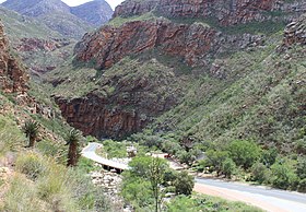
Buffelspoort is the westernmost of five defiles that cut through the Swartberg Mountain range, situated in the Western Cape province of South Africa. The others are the Seweweekspoort, Die Poort, where the Gamka River transects Die Hel, Meiringspoort, and Snykloof at its eastern extremity.

The Gouritz Cluster Biosphere Reserve is located in the Western Cape of South Africa. It is the 7th and largest of South Africa’s biosphere reserves; divided into four connected sectors ranging from sea level to 2,240 metres. The area is the only place in the world where three recognised biodiversity hotspots converge. The site is characterised by high endemism of plant species and threatened invertebrates including seven endemic species of the enigmatic beetle genus Colophon and 14 butterfly species. It provides a migratory route for large mammals such as the leopard and serves as a nursery for marine species.

<span class="mw-page-title-main">Garcia's Pass</span> Mountain pass in Western Cape, South Africa

The Garcia's Pass is a mountain pass across the Langeberg in the Western Cape province of South Africa, with its highest point at 548 m (1,798 ft) altitude. The regional road numbered R323 uses this pass on its leg between Riversdale in the south and Ladismith in the Little Karoo to the north. From Riversdale, the road winds to the Garcia Pass across the Langeberg to Muiskraal in the northern foothills. The maximum slope is 1:14 on the southern descend.

References

  1. Geological Journeys. Norman, N. and Whitfield, G. 2006
  2. G. Ross: Romance of Cape Mountain Passes. New Africa Books. 2004. ISBN   9780864866639. p.89.
  3. L. Nell: The Great Karoo. Struik. 2008. ISBN   1770073876 p.94.
  4. Meiringspoort - South African Mountain Passes
  5. Meiringspoort and Swartberg Nature Reserve