
The Province of the Cape of Good Hope, commonly referred to as the Cape Province and colloquially as The Cape, was a province in the Union of South Africa and subsequently the Republic of South Africa. It encompassed the old Cape Colony, as well as Walvis Bay, and had Cape Town as its capital. In 1994, the Cape Province was split up to form the new Eastern Cape, Northern Cape and Western Cape provinces, along with part of the North West.
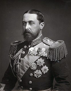
Alfred reigned as Duke of Saxe-Coburg and Gotha from 1893 to 1900. He was the second son and fourth child of Queen Victoria of the United Kingdom and Albert, Prince Consort. He was known as the Duke of Edinburgh from 1866 until he succeeded his paternal uncle Ernest II as the reigning Duke of Saxe-Coburg and Gotha in the German Empire.

Albert County is a county located in southeastern New Brunswick, Canada on Chignecto Bay in the Bay of Fundy. Prior to the abolition of county government in 1967, the shire town was Hopewell Cape. The county was established in 1845 from parts of Westmorland County and Saint John County, and named after Prince Albert.

The Western Cape is a province of South Africa, situated on the south-western coast of the country. It is the fourth largest of the nine provinces with an area of 129,449 square kilometres (49,981 sq mi), and the third most populous, with an estimated 7 million inhabitants in 2020. About two-thirds of these inhabitants live in the metropolitan area of Cape Town, which is also the provincial capital. The Western Cape was created in 1994 from part of the former Cape Province. The two largest cities are Cape Town and George.

The Prince Edward Islands are two small islands in the Subantarctic Indian Ocean that are part of South Africa. The islands are named Marion Island and Prince Edward Island.

Alberton is a city situated on the southern part of the East Rand, of the Gauteng Province in South Africa. It was incorporated into the Ekurhuleni metropolitan municipality in the year 2000 and celebrated its centenary year in 2005. According to the 2011 census conducted by Statistics South Africa, it has a population of 121,536; but this figure excludes the black township of Thokoza, which has a population of 105,827. Alberton is described as a typical bedroom community, one which is primarily residential in character, with most of its workers commuting to work in nearby suburbs or cities. The city has multiple access roads to all major freeways in Gauteng and is situated on the banks of the Natal Spruit close to the major urban centres of Johannesburg, which lies 15 km (9 mi) to the northwest - and Pretoria - which is 76 km (47 mi) to the north. Alberton has an elevation of approximately 1,570 m (5,150 ft) above sea level.

Prince Albert Municipality is a municipality located in the Western Cape Province of South Africa.

The Central Karoo District Municipality is a district municipality located in the Western Cape Province of South Africa. Its municipality code is DC5.

The Swartberg mountains are a mountain range in the Western Cape province of South Africa. It is composed of two main mountain chains running roughly east–west along the northern edge of the semi-arid Little Karoo. To the north of the range lies the other large semi-arid area in South Africa, the Great Karoo. Most of the Swartberg Mountains are above 2000 m high, making them the tallest mountains in the Western Cape. It is also one of the longest, spanning some 230 km from south of Laingsburg in the west to between Willowmore and Uniondale in the east. Geologically, these mountains are part of the Cape Fold Belt.

Merweville is a town located in Beaufort West Municipality, Western Cape.

Prince Albert is a small town in the Western Cape in South Africa. It is located on the southern edge of the Great Karoo, at the foot of the Swartberg mountains.

The N12 is a national route in South Africa which runs from George through Beaufort West, Kimberley, Klerksdorp and Johannesburg to eMalahleni.

Kleinzee or Kleinsee is a small Village on the west coast of the Northern Cape province in South Africa,

The Ecca Group is the second of the main subdivisions of the Karoo Supergroup of geological strata in southern Africa. It mainly follows conformably after the Dwyka Group in some sections, but in some localities overlying unconformably over much older basement rocks. It underlies the Beaufort Group in all known outcrops and exposures. Based on stratigraphic position, lithostratigraphic correlation, palynological analyses, and other means of geological dating, the Ecca Group ranges between Early to earliest Middle Permian in age.
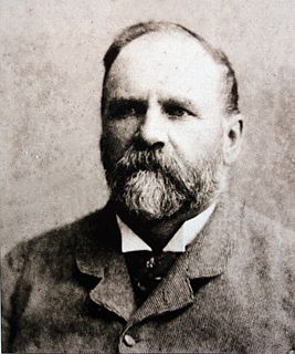
Thomas Charles John Bain was a South African road engineer. As a prolific road building pioneer, Bain was responsible for the planning and construction of more than 900 km of roads and mountain passes, many of them still in use today, over a career spanning from 1848 until 1888. These passes through the mountain ranges between the thin coastal plain and the interior of the former Cape Colony in South Africa, played a major role in opening up the vast hinterland of South Africa.

Bothasig is a suburban area of the City of Cape Town in Western Cape, South Africa. It is located north of Edgemead and east of Milnerton. It is located approximately 15 km north-east of the Cape Town city centre.
Prince Albert Road is a village located in Laingsburg Local Municipality, Western Cape.

The Cape Pioneer Trek is a 7-day South African mountain biking event through the Great and Little Karoo.

Lesseyton is a town in Enoch Mgijima Local Municipality in the Eastern Cape province of South Africa, located 14 km (8.7 mi) northwest of Queenstown. Almost all residents are Xhosa speakers. Lesseyton has two schools: Lesseyton Primary School and Ndlovukazi Public High School.

The Bokkeveld Group is the second of the three main subdivisions of the Cape Supergroup in South Africa. It overlies the Table Mountain Group and underlies the Witteberg Group. The Bokkeveld Group rocks are considered to range between Lower Devonian (Lochkovian) to Middle Devonian (Givetian) in age.


