This article needs additional citations for verification .(December 2009) |
Merweville | |
|---|---|
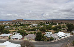 View of Merweville | |
 Merweville  Merweville | |
| Coordinates: 32°40′S21°31′E / 32.667°S 21.517°E | |
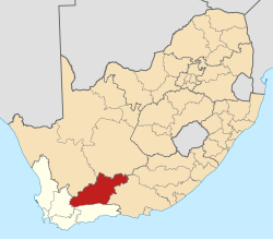
| Country | South Africa |
| Province | Western Cape |
| District | Central Karoo |
| Municipality | Beaufort West |
| Government | |
| • Councillor | Japie Van der Linde [1] (DA) |
| Area | |
• Total | 32.59 km2 (12.58 sq mi) |
| Population (2011) [2] | |
• Total | 1,592 |
| • Density | 49/km2 (130/sq mi) |
| Racial makeup (2011) | |
| • Black African | 9.3% |
| • Coloured | 78.1% |
| • Indian/Asian | 2.6% |
| • White | 8.9% |
| • Other | 1.1% |
| First languages (2011) | |
| • Afrikaans | 95.0% |
| • Zulu | 1.4% |
| • Other | 3.6% |
| Time zone | UTC+2 (SAST) |
| PO box | 6940 |
| Area code | 023 |
Merweville is a town located in Beaufort West Municipality, Western Cape.
Contents
Village 45 km north-west of Prince Albert Road and 130 km south-west of Beaufort West.