Central Karoo District Municipality

Last updated
Central Karoo
Sentraal Karoo
Central Karoo CoA.png
Map of South Africa with Central Karoo highlighted (2011).svg
Location in South Africa
Map of the Central Karoo district with local municipalities labelled.svg
Local municipalities within the Central Karoo
Coordinates: 32°40′S22°15′E / 32.667°S 22.250°E / -32.667; 22.250 Coordinates: 32°40′S22°15′E / 32.667°S 22.250°E / -32.667; 22.250
Country South Africa
Province Western Cape
Local municipalities
Government
[1]
  Type Municipal council
  MayorDr / Cllr A. Rabie
Area
  Total38,854 km2 (15,002 sq mi)
Population
 (2011) [2]
  Total71,011
  Density1.8/km2 (4.7/sq mi)
Racial makeup (2011)
[2]
   Black African 12.7%
   Coloured 76.2%
   Indian/Asian 0.4%
   White 10.1%
First languages (2011)
[2]
   Afrikaans 87.2%
   Xhosa 7.8%
   English 2.6%
  Other2.4%
Time zone UTC+2 (SAST)
Municipal codeDC5

The Central Karoo District Municipality (Afrikaans: Sentraal Karoo-distriksmunisipaliteit) is a district municipality located in the Western Cape Province of South Africa. Its municipality code is DC5.

Contents

Geography

The Central Karoo District Municipality is divided into three local municipalities, which are described in the following table.

NameSeatPopulation
(2011)
Area
(km2)
Density
(inhabitants/km2)
Laingsburg [3] Laingsburg 8,2898,7840.94
Prince Albert [4] Prince Albert 13,1368,1531.61
Beaufort West [5] Beaufort West 49,58621,9172.26
Total71,01138,8541.83

Adjacent municipalities

Demographics

The following statistics are from the 2011 Census. [6] Note that due to fuzzing applied to statistics, columns may not sum to exactly the indicated total.

First language

LanguagePopulation %
Afrikaans 60,07487.2%
Xhosa 5,3467.8%
English 1,7892.6%
Tswana 3990.6%
Sotho 3220.5%
Zulu 1820.3%
Sign language 1790.3%
Ndebele 1170.2%
Northern Sotho 930.1%
Venda 600.1%
Swazi 290.0%
Tsonga 180.0%
Other 3010.4%
Total68,909
Not applicable2,101

Race

RacePopulation %
Coloured 54,07676.2%
Black African 9,04512.7%
White 7,19710.1%
Indian or Asian 3000.4%
Other3940.6%
Total71,011

Gender

GenderPopulation %
Female36,24451.0%
Male34,76749.0%
Total71,011

Age

Age groupPopulation %
0–47,67910.8%
5–97,0309.9%
10–146,9769.8%
15–196,1598.7%
20–245,6728.0%
25–295,3437.5%
30–344,7406.7%
35–394,7736.7%
40–444,7866.7%
45–494,2796.0%
50–543,8115.4%
55–593,0474.3%
60–642,3443.3%
65–691,6362.3%
70–741,2431.8%
75–797511.1%
80–844050.6%
85+2030.3%
Total71,011

Politics

The council of the Central Karoo District Municipality consists of thirteen councillors. Six councillors are directly elected by party-list proportional representation, and seven are appointed by the councils of the local municipalities in the district: five by Beaufort West and one each by Laingsburg and Prince Albert.

As of February 2017 there are six councillors from the Democratic Alliance (DA), four from the African National Congress (ANC), two from the Karoo Gemeenskap Party (KGP) and one from the Karoo Democratic Force (KDF). The DA, KGP and KDF are in a coalition which governs the council. [7] The following table shows the detailed composition of the council. [7]

PartyDirectly
elected
Appointed by local councilsTotal
LaingsburgPrince AlbertBeaufort West
Democratic Alliance 3126
ANC 224
Karoo Gemeenskap Party 112
Karoo Democratic Force011

The following table shows the results of the election of the six directly elected councillors. [8] [9]

PartyVotesVote %Seats
Democratic Alliance 11,03745.4%3
ANC 9,81140.4%2
Karoo Gemeenskap Party 1,8077.4%1
Karoo Democratic Force1,0014.1%0
EFF 2881.2%0
Freedom Front Plus 2080.9%0
Independent Civic Organisation of South Africa 1340.6%0
Total24,2866
Valid votes24,28698.6%
Spoilt votes 3461.4%
Total votes cast24,632
Registered voters37,907
Turnout percentage65.0%

Related Research Articles

George Local Municipality Local municipality in Western Cape, South Africa

George Municipality is a municipality located in the Western Cape Province of South Africa. As of 2011 the population is 193,672. Its municipality code is WC044.

Witzenberg Local Municipality Local municipality in Western Cape, South Africa

Witzenberg Municipality is a local municipality located within the Cape Winelands District Municipality, in the Western Cape province of South Africa. As of 2011 it had a population of 115,946.

West Coast District Municipality District municipality in Western Cape, South Africa

The West Coast District Municipality is a district municipality located in the Western Cape province of South Africa. Its municipality code is DC1. Moorreesburg is the seat of the district. As of 2011 it had a total population of 391,766.

Langeberg Local Municipality Local municipality in Western Cape, South Africa

Langeberg Municipality is a local municipality located within the Cape Winelands District Municipality in the Western Cape province of South Africa. As of 2011 it had a population of 97,724. Its municipality code is WC026.

Beaufort West Local Municipality Local municipality in Western Cape, South Africa

Beaufort West Local Municipality is a municipality located in Western Cape Province, South Africa. As of 2011 the population is 49,586. Its municipality code is WC053.

Oudtshoorn Local Municipality Local municipality in Western Cape, South Africa

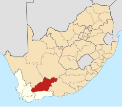
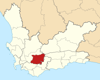
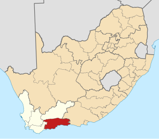
Oudtshoorn Municipality is a municipality located in the Western Cape Province of South Africa. As of 2011 the population was 95,933.

Prince Albert Local Municipality Local municipality in Western Cape, South Africa

Prince Albert Municipality is a municipality located in the Western Cape Province of South Africa.

Cape Winelands District Municipality District municipality in Western Cape, South Africa

The Cape Winelands District Municipality, formerly the Boland District Municipality, is a district municipality located in the Boland region of the Western Cape province of South Africa. As of 2011, it had a population of 787,490. The largest towns in the municipality are Paarl, Worcester, Stellenbosch and Wellington.

Breede Valley Local Municipality Local municipality in Western Cape, South Africa

Breede Valley Municipality is a local municipality located within the Cape Winelands District Municipality, in the Western Cape province of South Africa. As of 2007, it had a population of 166,825. Its municipality code is WC025.

Kannaland Local Municipality Local municipality in Western Cape, South Africa

Kannaland Municipality is a local municipality located within the Garden Route District Municipality in the Western Cape province of South Africa. The municipal area is situated in the western part of the Little Karoo and includes the towns of Ladismith, Calitzdorp and Zoar. As of 2011 it has a population of 24,767. Its municipality code is WC041.

Laingsburg Local Municipality Local municipality in Western Cape, South Africa

Laingsburg Municipality is a municipality located in the Western Cape Province of South Africa. As of 2011 the population is 8,289. Its municipality code is WC051.

Overberg District Municipality District municipality in Western Cape, South Africa

The Overberg District Municipality is a district municipality that governs the Overberg region in the Western Cape province of South Africa. It is divided into four local municipalities and includes the major towns of Grabouw, Caledon, Hermanus, Bredasdorp and Swellendam. The municipal area covers 12,241 square kilometres (4,726 sq mi) and had in 2007 an estimated population of 212,787 people in 60,056 households.

Laingsburg, Western Cape Place in Western Cape, South Africa

Laingsburg is a town located in the Western Cape province in South Africa. It is a relatively large agricultural town in the semi-arid Great Karoo. It was partially destroyed in a flash flood in 1981.

Garden Route District Municipality District municipality in Western Cape, South Africa

The Garden Route District Municipality is a district municipality located in the Western Cape Province of South Africa. Its municipality code is DC4.

2006 South African municipal elections

Municipal elections were held in South Africa on 1 March 2006, to elect members to the local governing councils in the municipalities of South Africa. The municipalities form the local government of South Africa and are subdivisions of the provinces, thus making them responsible for local service delivery, such as electricity, water and fire services.

The Western Cape province of South Africa is governed in a parliamentary system in which the people elect the Provincial Parliament, and the parliament elects the Premier as head of the executive. The Premier leads a cabinet of provincial ministers overseeing various executive departments. The provincial government is subject to the Constitution of the Western Cape and the Constitution of South Africa, which together form the supreme law of the province.

2011 South African municipal elections South African municipal elections held on 18 August 2011

Municipal elections were held in South Africa on 18 May 2011, electing new councils for all municipalities in the country. Municipal elections are held every five years, and the previous municipal elections were held in 2006. The first municipal elections following the reorganisation of municipalities took place in December 2000.

The Karoo Gemeenskap Party is a small South African regional political party which was formed in December 2010. In the 2011 municipal election, the KGP contested and won three out of seven seats in the council of the Prince Albert Local Municipality, while the African National Congress (ANC) and Democratic Alliance (DA) each won two. It also held one seat on the council of the Central Karoo District Municipality, in which the ANC and the DA each held six. In both councils the KGP entered into a coalition with the ANC to control the municipality. In the 2016 municipal election, the KGP won two out of seven seats in the council of the Prince Albert Local Municipality, while the DA won three and the ANC two. It also held two seats on the council of the Central Karoo District Municipality. In both councils the KGP entered into a coalition with the DA.

The Laingsburg Local Municipality council consists of seven members elected by mixed-member proportional representation. Four councillors are elected by first-past-the-post voting in four wards, while the remaining three are chosen from party lists so that the total number of party representatives is proportional to the number of votes received.

The council of the Hessequa Local Municipality consists of seventeen members elected by mixed-member proportional representation. Nine councillors are elected by first-past-the-post voting in nine wards, while the remaining eight are chosen from party lists so that the total number of party representatives is proportional to the number of votes received. In the election of 3 August 2016 no party obtained a majority; the Democratic Alliance (DA) and the Freedom Front Plus (FF+) subsequently formed a coalition to govern the municipality.

References

  1. "Contact list: Executive Mayors". Government Communication & Information System. Archived from the original on 14 July 2010. Retrieved 22 February 2012.
  2. 1 2 3 "Statistics by place". Statistics South Africa. Retrieved 27 September 2015.
  3. "Laingsburg Local Municipality". The Local Government Handbook. Retrieved 16 June 2013.
  4. "Prince Albert Local Municipality". The Local Government Handbook. Retrieved 16 June 2013.
  5. "Beaufort West Local Municipality". The Local Government Handbook. Retrieved 16 June 2013.
  6. Census 2011 statistical tables accessible through Stats SA SuperWEB Archived 2013-09-30 at the Wayback Machine .
  7. 1 2 "Political composition of councils February 2017" (PDF). Western Cape Department of Local Government. February 2017. Retrieved 4 June 2017.
  8. "Detailed DC 40% Ballot Results Report: DC5 - Central Karoo" (PDF). Electoral Commission. Retrieved 5 June 2017.
  9. "Seat Calculation Detail: DC5 - Central Karoo" (PDF). Electoral Commission. Retrieved 5 June 2017.