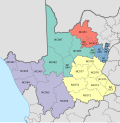
The Central Karoo District Municipality is a district municipality located in the Western Cape province of South Africa. Its municipality code is DC5.
The Sarah Baartman District Municipality, formerly the Cacadu District Municipality, is situated in the western part of the Eastern Cape province of South Africa, covering an area of 58,242 square kilometres. The area of the district municipality includes seven local municipalities. The seat is the city of Gqeberha, although Gqeberha is not itself in the district. As of 2011, the languages most spoken among the 388,201 inhabitants were isiXhosa and Afrikaans. The district code is DC10.
The Xhariep District Municipality is one of the 5 districts of the Free State province of South Africa. The municipality is the largest in the Free State geographically and is known for its vast land. It is home to the largest dam in the county, the Gariep Dam, and has two mines, situated in Jagersfontein and Koffiefontein. The natural resources and the geographical position of the municipality make it a site with good potential for investment and development. The seat is Trompsburg. As of 2011, the largest language group is Sotho who make up 45.3% of the total population of 146,259. The district code is DC16.

The Frances Baard District Municipality, previously the Diamantveld District Municipality, is one of the 5 districts of the Northern Cape province of South Africa. The seat of the municipality is Kimberley. As of 2011, the majority of its 324,814 residents speak Setswana. The district code is DC9.

The Namakwa District Municipality is one of the 5 districts of the Northern Cape province of South Africa. The seat of Namakwa is Springbok and the region is also known as Little Namaqualand. As of 2011, a majority of its 108,118 residents speak Afrikaans. The district code is DC6.

The ZF Mgcawu District Municipality, known before 1 July 2013 as the Siyanda District Municipality, is one of the 5 districts of the Northern Cape province of South Africa. The seat of the municipality is Upington. As of 2011, the majority (76%) of its 236,783 residents speak Afrikaans. The district code is DC8.

The John Taolo Gaetsewe District Municipality, formerly the Kgalagadi District Municipality, is one of the five districts of the Northern Cape province of South Africa. The seat of the authority is Kuruman. As of 2011, the majority of its 176,899 residents speak Setswana. The district code is DC45.

The Dr Kenneth Kaunda District Municipality, formerly the Southern District Municipality, is one of the 4 districts of the North West province of South Africa. The seat of the municipality is Klerksdorp. As of 2016, a plurality of its 742,821 residents speak Setswana. The majority of its residents live in the City of Matlosana. The district code is DC40. The district was formerly known as the Southern District Municipality. It is named after Kenneth Kaunda, the first President of Zambia.

Ubuntu Municipality is a local municipality within the Pixley ka Seme District Municipality, in the Northern Cape province of South Africa. Its seat is Victoria West. Other towns in the municipality are Richmond, Loxton and two small railway villages Hutchinson and Merriman.

Siyancuma Municipality is a local municipality within the Pixley ka Seme District Municipality, in the Northern Cape province of South Africa.
Emthanjeni Municipality is a local municipality within the Pixley ka Seme District Municipality, in the Northern Cape province of South Africa. Emthanjeni is a Xhosa word meaning "vein", symbolising the importance of an underground water supply system to the area. It is also a translation of the name of the municipality's seat, De Aar.
Umsobomvu Municipality is a local municipality within the Pixley ka Seme District Municipality, in the Northern Cape province of South Africa.

Siyathemba Municipality is a local municipality within the Pixley ka Seme District Municipality, in the Northern Cape province of South Africa.
Thembelihle Municipality, formerly known as Oranje-Karoo Municipality, is a local municipality within the Pixley ka Seme District Municipality, in the Northern Cape province of South Africa. Thembelihle is a Xhosa word meaning "good hope".

Kareeberg Municipality is a local municipality within the Pixley ka Seme District Municipality, in the Northern Cape province of South Africa. The name originates from a mountain range in the region, the Karee Mountains.

Renosterberg Municipality is a local municipality within the Pixley ka Seme District Municipality, in the Northern Cape province of South Africa.

Pixley Ka Seme Municipality is a local municipality within the Gert Sibande District Municipality, in the Mpumalanga province of South Africa. Volksrust is the seat of the municipality.
The Orania Representative Council is the local municipal representative council in the Northern Cape province of South Africa that governs the Afrikaner-town of Orania in the Pixley ka Seme District Municipality. During the implementation of a new municipal system in South Africa in 2000, the Orania Representative Council was the only representative council that was not abolished. Therefore, the Orania Representative Council is the only municipal body that still uses the old (pre-2000) municipal structure, based on the Local Government Transition Act of 1993.
The Siyathemba Local Municipality council in the Pixley ka Seme District Municipality district of the Northern Cape province of South Africa consists of eleven members elected by mixed-member proportional representation. Six councillors are elected by first-past-the-post voting in six wards, while the remaining five are chosen from party lists so that the total number of party representatives is proportional to the number of votes received. In the election of 1 November 2021 the African National Congress (ANC) lost its majority, but remains the largest party, with five seats.
The Pixley ka Seme Local Municipality is a Local Municipality in Mpumalanga in South Africa. The council consists of twenty-one members elected by mixed-member proportional representation. Eleven councillors are elected by first-past-the-post voting in eleven wards, while the remaining ten are chosen from party lists so that the total number of party representatives is proportional to the number of votes received. In the election of 1 November 2021 the African National Congress (ANC) won a majority of thirteen seats.


