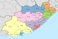
The Eastern Cape is one of the nine provinces of South Africa. Its capital is Bhisho, but its two largest cities are East London and Gqeberha.

Matzikama Municipality is a local municipality which governs the northernmost part of the Western Cape province of South Africa, including the towns of Vredendal, Vanrhynsdorp, Klawer and Lutzville, and the surrounding villages and rural areas. As of 2011, it had a population of 67,147. It forms part of the West Coast District Municipality, and its municipality code is WC011.

The Great Kei River is a river in the Eastern Cape province of South Africa. It is formed by the confluence of the Black Kei River and White Kei River, northeast of Cathcart. It flows for 320 km (199 mi) and ends in the Great Kei Estuary at the Indian Ocean with the small town Kei Mouth on the west bank. Historically the Great Kei River formed the southwestern border of the Transkei region as was formerly known as the Nciba River.

The Sarah Baartman District Municipality, formerly the Cacadu District Municipality, is situated in the western part of the Eastern Cape province of South Africa, covering an area of 58,242 square kilometres. The area of the district municipality includes seven local municipalities. The seat is the city of Gqeberha, although Gqeberha is not itself in the district. As of 2011, the languages most spoken among the 388,201 inhabitants were isiXhosa and Afrikaans. The district code is DC10.
Ngcobo, alternatively rendered Engcobo, is a town in the Eastern Cape province of South Africa.

Tarkastad is a Karoo semi-urban settlement situated on the banks Tarka River in the Eastern Cape province of South Africa. Tarkastad is on a plain to the north of the Winterberg mountain range on the R61 between Cradock and Komani and only three hours from Gqeberha. The name Tarkastad is believed to come from the Khoi-Khoi word Traka or the Celtic word Tarka and the Afrikaans word Stad. The fact that the town is overlooked by Martha and Mary; two peaks which look like two women resting after a hard day's work, also lends to the name.
Whittlesea is a semi-rural town situated in the Hewu district, 37 km south of Queenstown, Eastern Cape Province, South Africa. The town is made up of the townships Ekuphumleni, Bhede, Extension 4, Extension 5 and Sada. The town falls under the Enoch Mgijima Local Municipality which is under the Chris Hani District Municipality. Surrounding Whittlesea are 36 villages which make up the Hewu district.

Matatiele Municipality is a local municipality within the Alfred Nzo District Municipality, in the Eastern Cape province of South Africa. It adjoins Lesotho to the north, Elundini to the south-west, and Greater Kokstad to the east and its 4,352 km² makes the Matatiele Municipality largest of four municipalities in the district at almost half of its geographical area. According to the South African National Census of 2011, its 203,483 residents and 49,527 households makes Matatiele Municipality the second largest populated area in the Alfred Nzo District Municipality behind Mbizana.

Intsika Yethu Municipality is a local municipality within the Chris Hani District Municipality, in the Eastern Cape province of South Africa. The municipality is one of the six local municipality in this district. Intsika Yethu is an isiXhosa word meaning "our pillars".

Maletswai Local Municipality was an administrative area in the Joe Gqabi District of the Eastern Cape in South Africa. The municipality was merged with Gariep Local Municipality immediately after the August 2016 Local Municipal Elections to form the new Walter Sisulu Local Municipality.

Inkwanca Local Municipality was a local municipality that forms part of the Chris Hani District Municipality in the Eastern Cape province of South Africa. Inkwanca is an isiXhosa name meaning cold. The municipal area is the coldest area in the country and the lowest temperatures are recorded in the area every year. After municipal elections on 3 August 2016 it was merged into the larger Enoch Mgijima Local Municipality.

Tsolwana Local Municipality was an administrative area in the Chris Hani District of the Eastern Cape in South Africa. Tsolwana is an isiXhosa name which means "something with a sharp ending or a tip", referring the mountains around the whole area. After municipal elections on 3 August 2016 it was merged into the larger Enoch Mgijima Local Municipality.

Dr AB Xuma Local Municipality is a local municipality within the Chris Hani District Municipality, in the Eastern Cape province of South Africa. Ngcobo is an isiXhosa word for a sweet grass found in the area.
Jamestown is a town on the N6 national road 58 km south of Aliwal North and 105 km north of Komani in the Joe Gqabi District Municipality of the Eastern Cape, South Africa. It is at the centre of a fertile sheep, cattle and wheat-farming area and was the terminus of a branch railway line from Molteno. It was named after James Wagenaar, original owner of the farm on which the town was laid out.

Sterkstroom is a settlement in Enoch Mgijima Local Municipality of the Chris Hani District in the Eastern Cape province of South Africa.
All Saints Hospital is a Provincial government funded hospital in Ngcobo, Eastern Cape in South Africa. Situated in Ngcobo, around 80km from Mthatha, the hospital serves the entire Ngcobo and some of the Cofimvaba community of over 148 000 people.
Molteno Hospital is a Provincial government funded hospital for the Enoch Mgijima Local Municipality area in Molteno, Eastern Cape in South Africa.
The Eastern Cape province of South Africa is governed in a parliamentary system in which the people elect the provincial legislature and the legislature, in turn, elects the Premier as head of the executive. The Premier leads an Executive Council consisting of members who oversee various executive departments. The structure of the provincial government is defined by chapter six of the Constitution of South Africa.

Thornhill is a rural village in Enoch Mgijima Local Municipality under the Chris Hani District Municipality in the Eastern Cape province of South Africa. Under the previous political dispensation it fell in the Ciskei homeland. Thornhill is the biggest village in the [Ntabethemba].

Enoch Mgijima Municipality is a local municipality within the Chris Hani District Municipality, in the Eastern Cape province of South Africa. It was established after the August 2016 local elections by merging the Tsolwana, Inkwanca, and Lukhanji local municipalities.


