
The first modern humans are believed to have inhabited South Africa more than 100,000 years ago. South Africa's first known inhabitants have been collectively referred to as the Khoisan, the Khoekhoe and the San. Starting in about 400 AD, these groups were then joined by the Bantu ethnic groups who migrated from Western and Central Africa during what is known as the Bantu expansion. These Bantu groups were mainly limited to the area north of the Soutpansberg and the northeastern part of South Africa until the later Middle Iron Age, after which they started migrating south into the interior of the country.

Cape Coloureds are a South African group of multiracial people who are from the Cape region in South Africa which consists of the Western Cape and the Eastern Cape. Their ancestry comes from the interracial mixing between the White, the indigenous Khoi and San, the Xhosa plus other Bantu people, slaves imported from the Dutch East Indies, immigrants from the Levant or Yemen. People from India and the islands within the Indian Ocean region were also taken to the Cape and sold into slavery by the Dutch settlers. Eventually all these ethnic and racial group intermixed with each forming a group of mixed race people that became the "Cape Coloureds".

The Great Trek was a northward migration of Dutch-speaking settlers who travelled by wagon trains from the Cape Colony into the interior of modern South Africa from 1836 onwards, seeking to live beyond the Cape's British colonial administration. The Great Trek resulted from the culmination of tensions between rural descendants of the Cape's original European settlers, known collectively as Boers, and the British. It was also reflective of an increasingly common trend among individual Boer communities to pursue an isolationist and semi-nomadic lifestyle away from the developing administrative complexities in Cape Town. Boers who took part in the Great Trek identified themselves as voortrekkers, meaning "pioneers" or "pathfinders" in Dutch and Afrikaans.

The Eastern Cape is one of the nine provinces of South Africa. Its capital is Bhisho, and its largest city is Gqeberha. Due to its climate and nineteenth-century towns, it is a common location for tourists. It is also known for having been home to many anti-apartheid activists, including Nelson Mandela.

The Griquas are a subgroup of mixed-race heterogeneous formerly Xiri-speaking nations in South Africa with a unique origin in the early history of the Dutch Cape Colony. Like the Boers they migrated inland from the Cape and in the 19th century established several states in what is now South Africa and Namibia. The Griqua consider themselves as being South Africa’s first multiracial nation with people descended directly from Dutch settlers in the Cape, and local peoples.
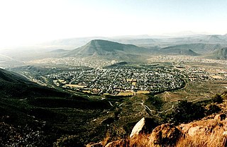
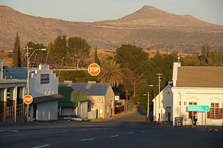
Graaff-Reinet is a town in the Eastern Cape Province of South Africa. It is the oldest town in the province and the fifth oldest town in South Africa, after Cape Town, Stellenbosch, Simon's Town, Paarl and Swellendam. The town was the centre of a short-lived republic in the late 18th century. The town was a starting point for Great Trek groups led by Gerrit Maritz and Piet Retief and furnished large numbers of the Voortrekkers in 1835–1842.

The Great Fish River is a river running 644 kilometres (400 mi) through the South African province of the Eastern Cape. The coastal area between Port Elizabeth and the Fish River mouth is known as the Sunshine Coast. The Great Fish River was originally named Rio do Infante, after João Infante, the captain of one of the caravels of Bartolomeu Dias. Infante visited the river in the late 1480s.

The Komati River, also known as the Inkomati River or Incomati River, is a river in South Africa, Eswatini and Mozambique. Originating in north-western Eswatini, it is joined by the Crocodile River in the Lebombo Mountains, enters far south-western Mozambique below the border town of Komatipoort, and enters the Indian Ocean around 24 km (15 mi) north-east of Maputo.

Queenstown, officially Komani, is a town in the middle of the Eastern Cape Province of South Africa, roughly halfway between the smaller towns of Cathcart and Sterkstroom on the N6 national route. The town was established in 1853 and is currently the commercial, administrative, and educational centre of the surrounding farming district.
Cradock, officially Nxuba, is a town in the Eastern Cape Province of South Africa, in the upper valley of the Great Fish River, 250 kilometres (160 mi) by road northeast of Gqeberha. The town is the administrative seat of the Inxuba Yethemba Local Municipality in the Chris Hani District of the Eastern Cape.
Kirkwood, officially Nqweba is a town in the Eastern Cape Province of South Africa. It is situated on the banks of the Sundays River in the eponymously named Sundays River Valley, which forms part of the Sundays River Valley Municipality in the Sarah Baartman District Municipality of the Eastern Cape.
Afrikaners are a Southern African ethnic group descended from predominantly Dutch settlers first arriving at the Cape of Good Hope in 1652. Until 1994, they dominated South Africa's politics as well as the country's commercial agricultural sector.

The Battle of Elands River took place near the Elands River Poort mountain pass on 17 September 1901 during the Second Boer War. During the battle a Boer raiding force under Jan Smuts destroyed a British cavalry squadron led by Captain Sandeman, a cousin of Winston Churchill, on the Modderfontein farm. This battle is therefore also known as the Battle of Modderfontein.
Tsolwana Nature Reserve is an 8,500 hectare nature reserve situated on the edge of the Winterberg Mountain range. It is located 60 km west of Queenstown, and 30 km south- east of Tarkastad in Eastern Cape Province, South Africa and is managed by Eastern Cape Parks Board. Its western boundary is formed by the upper Black Kei River. The reserve's name originates from the Xhosa word for "spike", due to the presence of the cone-shaped hill, Spitskop.
Thembelihle Municipality, formerly known as Oranje-Karoo Municipality, is a local municipality within the Pixley ka Seme District Municipality, in the Northern Cape province of South Africa. Thembelihle is a Xhosa word meaning "good hope".

Touws River is a small railway town of 8,126 people in the Western Cape province of South Africa. It is located on the river of the same name, about 160 kilometres (100 mi) north-east of Cape Town. The Touwsrivier CPV Solar Project is located just outside of the town and supplies 50 MW to the national electrical grid.
Elands River may refer to any of the following rivers in South Africa:
People of the Karoo refers to notable individuals who come from, or whose lives have included substantial engagement with, the area known as the Karoo. The Karoo is a widespread physiographic province in the western interior of South Africa, straddling much of the Northern Cape, southern Free State, Eastern Cape interior and parts of the Western Cape Provinces.

Thornhill is a rural village in Enoch Mgijima Local Municipality under the Chris Hani District Municipality in the Eastern Cape province of South Africa. Under the previous political dispensation it fell in the Ciskei homeland.


