
Cape Town is South Africa's oldest city. It serves as the country's legislative capital, being the seat of the South African Parliament. It is the country's second-largest city and the largest in the Western Cape. The city is part of the City of Cape Town metropolitan municipality.

South Africa occupies the southern tip of Africa, its coastline stretching more than 2,850 kilometres from the desert border with Namibia on the Atlantic (western) coast southwards around the tip of Africa and then northeast to the border with Mozambique on the Indian Ocean. The low-lying coastal zone is narrow for much of that distance, soon giving way to a mountainous escarpment that separates the coast from the high inland plateau. In some places, notably the province of KwaZulu-Natal in the east, a greater distance separates the coast from the escarpment. Although much of the country is classified as semi-arid, it has considerable variation in climate as well as topography. The total land area is 1,220,813 km2 (471,359 sq mi). It has the 23rd largest Exclusive Economic Zone of 1,535,538 km2 (592,875 sq mi).

Cape Agulhas is a rocky headland in Western Cape, South Africa. It is the geographic southern tip of Africa and the beginning of the traditional dividing line between the Atlantic and Indian Oceans according to the International Hydrographic Organization. It is approximately half a degree of latitude, or 55 kilometres (34 mi), further south than the Cape of Good Hope.

A Mediterranean climate, also called a dry summer climate, described by Köppen as Cs, is a temperate climate type that occurs in the lower mid-latitudes. Such climates typically have dry summers and wet winters, with summer conditions ranging from warm to hot and winter conditions typically being mild. These weather conditions are typically experienced in the majority of Mediterranean-climate regions and countries, but remain highly dependent on proximity to the ocean, altitude and geographical location.
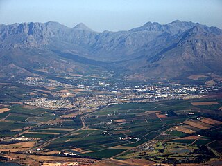
Stellenbosch is a town in the Western Cape province of South Africa, situated about 50 kilometres east of Cape Town, along the banks of the Eerste River at the foot of the Stellenbosch Mountain. The town became known as the City of Oaks or Eikestad in Afrikaans and Dutch due to the large number of oak trees that were planted by its founder, Simon van der Stel, to grace the streets and homesteads.

An oceanic climate, also known as a marine climate, is the temperate climate sub-type in Köppen classification represented as Cfb, typical of west coasts in higher middle latitudes of continents, generally featuring cool summers and mild winters, with a relatively narrow annual temperature range and few extremes of temperature. Oceanic climates can be found in both hemispheres generally between 45 and 63 latitude, most notably in northwestern Europe, northwestern America, as well as New Zealand. Other varieties of climates usually classified together with these include subtropical highland climates, represented as Cwb or Cfb, and subpolar oceanic or cold subtropical highland climates, represented as Cfc or Cwc. Subtropical highland climates occur in some mountainous parts of the subtropics or tropics, some of which have monsoon influence, while their cold variants and subpolar oceanic climates occur near polar or tundra regions.

Plettenberg Bay, nicknamed Plet or Plett, is the primary town of the Bitou Local Municipality in the Western Cape Province of South Africa. As of the census of 2001, there were 29,149 population. It was originally named Bahia Formosa by early Portuguese explorers and lies on South Africa's Garden Route 210 km from Port Elizabeth and about 600 km from Cape Town.

Knysna is a town with 76,150 inhabitants in the Western Cape province of South Africa. and is one of the destinations on the loosely defined Garden Route tourist route. It is situated 60 kilometres east of the city of George on the N2 highway, and 33 kilometres west of the Plettenberg Bay on the same road.

Worcester is a town in the Western Cape, South Africa. It is the third-largest city in the western cape province of South Africa. It is located 120 kilometres (75 mi) north-east of Cape Town on the N1 highway north to Johannesburg.

Queenstown, officially Komani, is a town in the middle of the Eastern Cape Province of South Africa, roughly halfway between the smaller towns of Cathcart and Sterkstroom on the N6 National Route. The town was established in 1853 and is currently the commercial, administrative, and educational centre of the surrounding farming district.
Mount Selinda, at an altitude of 1,100 metres, is a village and mission station in the province of Manicaland in the eastern mountains of Zimbabwe. Located close to the Mozambique border, it lies in an area of outstanding natural beauty. Mount Selinda sits on an east-facing slope, on the very edge of the Chirinda Forest Botanical Reserve – the southernmost tropical rainforest in Africa.

Barrydale is a village located on the border of the Overberg and Klein Karoo regions of the Western Cape Province in South Africa. It was named after Joseph Barry, a well-known merchant of the 19th century. It is situated at the northern end of the Tradouws Pass which winds its way through the mountains to Swellendam.

Tarkastad is a Karoo semi-urban settlement situated on the banks Tarka River in the Eastern Cape province of South Africa. Tarkastad is on a plain to the north of the Winterberg mountain range on the R61 between Cradock and Komani and only three hours from Gqeberha. The name Tarkastad is believed to come from the Khoi-Khoi word Traka or the Celtic word Tarka and the Afrikaans word Stad. The fact that the town is overlooked by Martha and Mary; two peaks which look like two women resting after a hard day's work, also lends to the name.

Australia's climate is governed mostly by its size and by the hot, sinking air of the subtropical high pressure belt. This moves north-west and north-east with the seasons. The climate is variable, with frequent droughts lasting several seasons, thought to be caused in part by the El Niño-Southern Oscillation. Australia has a wide variety of climates due to its large geographical size. The largest part of Australia is desert or semi-arid. Only the south-east and south-west corners have a temperate climate and moderately fertile soil. The northern part of the country has a tropical climate, varying between grasslands and desert. Australia holds many heat-related records: the continent has the hottest extended region year-round, the areas with the hottest summer climate, and the highest sunshine duration.

Grabouw is a town located in the Western Cape province of South Africa. Grabouw is located some 65 km south-east of Cape Town, over Sir Lowry's Pass from Somerset West, along the N2 highway.The town is the commercial centre for the vast Elgin Valley, the largest single export fruit-producing area in Southern Africa, which extends between the Hottentots-Holland, Kogelberg, Groenland, and Houwhoek Mountains. The town's population has grown rapidly, with 44 593 people in 2019 from 21 593 as listed by the 2001 census.

The wildlife of South Africa consists of the flora and fauna of this country in southern Africa. The country has a range of different habitat types and an ecologically rich and diverse wildlife, vascular plants being particularly abundant, many of them endemic to the country. There are few forested areas, much savanna grassland, semi-arid Karoo vegetation and the fynbos of the Cape Floristic Region. Famed for its national parks and big game, 297 species of mammal have been recorded in South Africa, as well as 849 species of bird and over 20,000 species of vascular plants.
Breede River Valley is a region of Western Cape Province, South Africa known for being the largest fruit and wine producing valley in the Western Cape, as well as South Africa's leading race-horse breeding area. It is part of the Boland bordering on becoming Little Karoo towards the east.
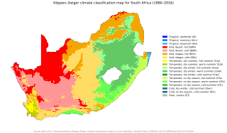
The climate of South Africa is determined by South Africa's situation between 22°S and 35°S, in the Southern Hemisphere's subtropical zone, and its location between two oceans, Atlantic and the Indian.
Tsolwana Nature Reserve is an 8,500 hectare nature reserve situated on the edge of the Winterberg Mountain range. It is located 60 km west of Queenstown, and 30 km south- east of Tarkastad in Eastern Cape Province, South Africa and is managed by Eastern Cape Parks Board. Its western boundary is formed by the upper Black Kei River. The reserve's name originates from the Xhosa word for "spike", due to the presence of the cone-shaped hill, Spitskop.

Molteno is a town in the Eastern Cape province of South Africa.


