Makana Local Municipality

Last updated

Makana
Makana CoA.png
Map of the Eastern Cape with Makana highlighted.svg
Location in the Eastern Cape
Country South Africa
Province Eastern Cape
District Sarah Baartman
Seat Makhanda
Wards 14
Government
[1]
  Type Municipal council
  MayorYandiswa Vara(ANC)
  SpeakerMthuthuzeli Matyumza
  Chief WhipVacant
Area
  Total4,376 km2 (1,690 sq mi)
Population
 (2011) [2]
  Total80,390
  Density18/km2 (48/sq mi)
Racial makeup (2011)
[2]
   African 78.0%
   Coloured 12.1%
   Indian/Asian 0.7%
   White 8.7%
First languages (2011)
[2]
   Xhosa 71.5%
   Afrikaans 14.8%
   English 10.5%
  Other3.2%
Time zone UTC+2 (SAST)
Municipal codeEC104

Makana Municipality (Xhosa : uMasipala wase Makana; Afrikaans : Makana Munisipaliteit) is a local municipality which governs the town of Makhanda and surrounding areas in the Eastern Cape province of South Africa. It forms part of the Sarah Baartman District Municipality. The municipality is named after a Xhosa prophet and leader, Makana. [3]

Contents

Main places

The 2011 census divided the municipality into the following main places: [4]

PlaceCodePopulationArea (km2)Most spoken language
Alicedale 264005 1,9323.9Afrikaans
Makhanda 264004 50,21762.7Xhosa
KwaNonzwakazi 264006 1,9400.8Xhosa
Rhini 264003 17,0472.4Xhosa
Riebeek East 264001 75322.5Xhosa
Sidbury 264007 1157.9Xhosa
Non-urban areas 264002 8,3864,275.5Xhosa
Total80,3904,375.6Xhosa

Politics

The municipal council consists of twenty-seven members elected by mixed-member proportional representation. Fourteen councillors are elected by first-past-the-post voting in fourteen wards, while the remaining thirteen are chosen from party lists so that the total number of party representatives is proportional to the number of votes received. In the election of 1 November 2021 the African National Congress (ANC) won a majority of fourteen seats on the council. The following table shows the results of the election. [5]

PartyWardListTotal
seats
Votes%SeatsVotes%Seats
African National Congress 9,34149.53119,33351.82314
Makana Citizens Front 3,27717.3803,39618.8655
Democratic Alliance 3,12716.5823,18217.6735
Economic Freedom Fighters 1,1305.9901,0505.8322
Independent candidates 1,0995.8311
Makana Independent New Deal 3301.7503712.0600
Patriotic Alliance 1840.9802221.2300
Azanian People's Organisation 1420.7501720.9500
Freedom Front Plus 1350.7201360.7600
African Transformation Movement 950.5001490.8300
Total18,860100.001418,011100.001327
Valid votes18,86098.1318,01196.09
Invalid/blank votes3601.877323.91
Total votes19,220100.0018,743100.00
Registered voters/turnout43,66444.0243,66442.93

Friendship Co-operation Agreement

In February 2011, Makana Municipality entered into a "Friendship Co-operation Agreement" with Raseborg Municipality in Finland. The project, which is to last three years, seeks to facilitate information sharing in the fields of economic development, arts & culture, women development, youth development, and education. [6] [7]

Provincial Administration

On 28 August 2014 the Municipality was placed under administration in response to financial and infrastructural crises. [8] The interim administration order, made in terms of section 139(1)(b) of the South African Constitution, is expected to be reviewed after three months. [9] Shortly after the administration order was announced, news of a damning forensic report — the Kabuso report — naming several municipal officials purported to be involved in financial impropriety was made public. [10]

Dissolution

In 2014 the city council was placed under administration by the courts for three months. This was due to its financial instability and inability to provide basic services. [11] This intervention was not successful [11] and on 14 January 2020, the Eastern Cape High Court dissolved the municipal council. The municipality will subsequently head to fresh elections. [12] [13] The Makhanda High Court made legal history by ordering the Makana Municipal Council to be dissolved. [11] The court ruled that its ongoing failure to provide services to the residents of Makhanda was unconstitutional.

Residents of Makhanda have widely welcomed a high court ruling that the Makana Municipal Council must be dissolved over its unconstitutional failure to provide services. It was the first such order by a court in South Africa. “This judgment sparks hope. We couldn’t live like this any more. We are very happy,” said Ayanda Kota, the founder of the Unemployed People's Movement, the organisation that brought the application. [7]

Related Research Articles

<span class="mw-page-title-main">Knysna Local Municipality</span> Local municipality in Western Cape, South Africa

Knysna Municipality is a local municipality within the Garden Route District Municipality, in the Western Cape province of South Africa. As of 2011, the population is 68,659. Its municipal code is WC048.

<span class="mw-page-title-main">George Local Municipality</span> Local municipality in Western Cape, South Africa

George Municipality is a local municipality within the Garden Route District Municipality, in the Western Cape province of South Africa. As of 2011, the population is 193,672. Its municipality code is WC044.

<span class="mw-page-title-main">Mossel Bay Local Municipality</span> Local municipality in Western Cape, South Africa

Mossel Bay Municipality is a local municipality within the Garden Route District Municipality, in the Western Cape province of South Africa. As of 2011, the population was 89,430.

<span class="mw-page-title-main">Bitou Local Municipality</span> Local municipality in Western Cape, South Africa

Bitou Municipality, formerly known as Plettenberg Bay Municipality, is a local municipality within the Garden Route District Municipality, in the Western Cape province of South Africa. Its municipality code is WC047.

<span class="mw-page-title-main">Langeberg Local Municipality</span> Local municipality in Western Cape, South Africa

Langeberg Municipality, known before 28 August 2009 as Breede River/Winelands Municipality, is a local municipality located within the Cape Winelands District Municipality, in the Western Cape province of South Africa. As of 2011, it had a population of 97,724. Its municipality code is WC026.

<span class="mw-page-title-main">Beaufort West Local Municipality</span> Local municipality in Western Cape, South Africa

Beaufort West Municipality is a local municipality located in the Western Cape province of South Africa. As of 2011, the population is 49,586. Its municipality code is WC053.

<span class="mw-page-title-main">Oudtshoorn Local Municipality</span> Local municipality in Western Cape, South Africa

Oudtshoorn Municipality is a local municipality within the Garden Route District Municipality, in the Western Cape province of South Africa. As of 2011, the population was 95,933.

<span class="mw-page-title-main">Drakenstein Local Municipality</span> Local municipality in Western Cape, South Africa

Drakenstein Municipality is a local municipality located within the Cape Winelands District Municipality, in the Western Cape province of South Africa. As of 2011, it had a population of 251,262. Its municipality code is WC023.

<span class="mw-page-title-main">Bergrivier Local Municipality</span> Local municipality in Western Cape, South Africa

Bergrivier Municipality is a local municipality in the Western Cape province of South Africa. It governs the towns of Piketberg, Velddrif and Porterville, as well as the surrounding villages and rural areas. As of 2011, it had a population of 61,897. It is located within the West Coast District Municipality and its municipality code is WC013.

<span class="mw-page-title-main">Breede Valley Local Municipality</span> Local municipality in Western Cape, South Africa

Breede Valley Municipality is a local municipality located within the Cape Winelands District Municipality, in the Western Cape province of South Africa. As of 2007, it had a population of 166,825. Its municipality code is WC025.

<span class="mw-page-title-main">Laingsburg Local Municipality</span> Local municipality in Western Cape, South Africa

Laingsburg Municipality is a local municipality located in the Western Cape province of South Africa. As of 2011, the population is 8,289. Its municipality code is WC051.

<span class="mw-page-title-main">Hessequa Local Municipality</span> Local municipality in Western Cape, South Africa

Hessequa Municipality, known before 24 June 2005 as Langeberg Municipality, is a local municipality within the Garden Route District Municipality, in the Western Cape province of South Africa. It is flanked by the lower Breede River to the west and the Gourits River to the east. As of 2011, the population was 52,642. Its municipality code is WC042. The name Hessequa, meaning "people of the trees", refers to the indigenous Khoikhoi people.

<span class="mw-page-title-main">Saldanha Bay Local Municipality</span> Local municipality in Western Cape, South Africa

Saldanha Bay Municipality is a local municipality located within the West Coast District Municipality, in the Western Cape province of South Africa. As of 2011, it had a population of 99,193. Its municipality code is WC014.

<span class="mw-page-title-main">Swartland Local Municipality</span> Local municipality in Western Cape, South Africa

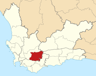
Swartland Municipality is a local municipality located in the Western Cape province of South Africa. Malmesbury is the seat of the municipality. As of 2016, it had a population of 133,762. Its municipality code is WC015.

<span class="mw-page-title-main">Theewaterskloof Local Municipality</span> Local municipality in Western Cape, South Africa

Theewaterskloof Municipality is a local municipality located within the Overberg District Municipality, in the Western Cape province of South Africa. As of 2007, the population was 108,790. Its municipality code is WC031. The enormous Theewaterskloof Dam, which provides water for Cape Town and the surrounding areas, is located in this municipality.

<span class="mw-page-title-main">Makhanda, South Africa</span> Town in Eastern Cape, South Africa

Makhanda, also known as Grahamstown, is a town of about 140,000 people in the Eastern Cape province of South Africa. It is situated about 110 kilometres (70 mi) northeast of Gqeberha and 130 kilometres (80 mi) southwest of East London. It is the largest town in the Makana Local Municipality, and the seat of the municipal council. It also hosts Rhodes University, the Eastern Cape Division of the High Court, the South African Library for the Blind (SALB), a diocese of the Anglican Church of Southern Africa, and 6 South African Infantry Battalion. Furthermore, located approximately 3 km south-east of the town lies the world renowned Waterloo Farm, the only estuarine fossil site in the world from 360 million years ago with exceptional soft-tissue preservation.

<span class="mw-page-title-main">Raseborg</span> Town in Uusimaa, Finland

Raseborg is a town and municipality of Finland. It was created on January 1, 2009, when the municipalities of Ekenäs, Karis and Pohja were consolidated into a single town, creating the largest Swedish-speaking-majority city of Finland in terms of population. Of these, Ekenäs now serves as the administrative center of Raseborg. The name of the new town is based on the Raseborg Castle located in Ekenäs, or formerly in the municipality of Snappertuna. Historically the name of the county was also Raseborg in the 14th century.

<span class="mw-page-title-main">Thembelihle Local Municipality</span> Local municipality in Northern Cape, South Africa

Thembelihle Municipality, formerly known as Oranje-Karoo Municipality, is a local municipality within the Pixley ka Seme District Municipality, in the Northern Cape province of South Africa. Thembelihle is a Xhosa word meaning "good hope".

<span class="mw-page-title-main">Makhanda (prophet)</span> Xhosa indigenous doctor

Makhanda, also spelled Makana and also known as Nxele, was a Xhosa indigenous doctor. He served as a top advisor to Chief Ndlambe. During the Xhosa Wars, on the 22nd of April, 1819, he initiated an abortive assault on the town of Grahamstown, in what was then the Cape Colony.

<span class="mw-page-title-main">Inkwanca Local Municipality</span> Former local municipality in Eastern Cape, South Africa

Inkwanca Local Municipality was a local municipality that forms part of the Chris Hani District Municipality in the Eastern Cape province of South Africa. Inkwanca is an isiXhosa name meaning cold. The municipal area is the coldest area in the country and the lowest temperatures are recorded in the area every year. After municipal elections on 3 August 2016 it was merged into the larger Enoch Mgijima Local Municipality.

References

  1. "Contact list: Executive Mayors". Government Communication & Information System. Archived from the original on 14 July 2010. Retrieved 22 February 2012.
  2. 1 2 3 "Statistics by place". Statistics South Africa. Retrieved 27 September 2015.
  3. South African Languages - Place names
  4. "Makana Local Municipality". Census 2011.
  5. "Election Result Table for LGE2021 — Makana". Election Result Table Generator - Adrian Frith. Retrieved 5 March 2022.
  6. Groepies, Alvaira (25 November 2010). "Finland trip feedback". Makana Municipality. Archived from the original on 19 April 2012. Retrieved 29 November 2011.
  7. 1 2 Ellis, Estelle (14 January 2020). "Residents hail high court order dissolving Makana Municipal Council". Daily Maverick.
  8. "Gordhan seals Makana handover". Grocott's Mail. 28 August 2014. Archived from the original on 3 September 2014. Retrieved 3 September 2014.
  9. Velaphi, Sithandiwe (29 August 2014). "Makana under administration for 3 months". The New Age. Archived from the original on 4 September 2014. Retrieved 3 September 2014.
  10. "Names behind Makana fiasco". DispatchLIVE. Times Media Group. 3 September 2014. Retrieved 3 September 2014.
  11. 1 2 3 Kotze, Joleen Steyn (20 January 2020). "Landmark court ruling highlights crisis in South Africa's cities and towns". The Conversation. Retrieved 28 January 2020.
  12. Nowicki, Lucas (14 January 2020). "Makana Municipality to be dissolved, placed under administration - court orders". News24. Retrieved 14 January 2020.
  13. Carlisle, Adrienne (14 January 2020). "Court rules Makana council must be dissolved". DispatchLIVE. Retrieved 14 January 2020.

33°17′S26°31′E / 33.283°S 26.517°E / -33.283; 26.517