N3 (South Africa)

Last updated

SA road N3.svg
National route N3
Map of the N3 (South Africa) with labels.svg
Route information
Maintained by SANRAL, N3TC, eThekwini Metropolitan Municipality
Length578 km (359 mi)
Major junctions
Southeast endPine Street/Commercial Road in Durban
Major intersectionsSA road N2 jct.svg N2 in Durban
SA road N11 jct.svg N11 near Ladysmith
SA road N5 jct.svg N5 at Harrismith
SA road N17 jct.svg N17 near Germiston
SA road N12 jct.svg N12 near Germiston
SA road N12 jct.svg N12 at Bedfordview
Northwest endSA road N1 jct.svg N1 near Sandton
Location
Country South Africa
Provinces KwaZulu-Natal, Free State, Gauteng
Major cities
Highway system
SA road N2.svg N2 SA road N4.svg N4

The N3 is a national route in South Africa that connects Johannesburg and Durban, [1] respectively South Africa's largest and third-largest cities. Johannesburg is the financial and commercial heartland of South Africa, while Durban is South Africa's key port and one of the busiest ports in the Southern Hemisphere and is also a holiday destination. Durban is the port through which Johannesburg imports and exports most of its goods. As a result, the N3 is a very busy highway and has a high volume of traffic.

Contents

Route

The N3 is divided into 12 sections, starting with section 1 in Durban and ending with section 12 in Johannesburg. Between the two cities, the route passes the following towns and cities: Pinetown, Cato Ridge, Pietermaritzburg, Howick, Mooi River, Estcourt, Ladysmith, Van Reenen, Harrismith, Warden, Villiers, Heidelberg and Germiston. It no longer passes through most of these towns, as bypasses have been built around all of them (the N3 does not pass through any city centres). The last bypass that was built was around the town of Warden.

KwaZulu-Natal

N3 freeway approaching Durban, N2/N3 E.B. Cloete Interchange in the foreground DurbanN3-aerial.jpg
N3 freeway approaching Durban, N2/N3 E.B. Cloete Interchange in the foreground

The N3 begins in the Durban Central Business District at Pine Street and Commercial Road as a dual-carriageway freeway and heads west, passing through Berea and Mayville before intersecting with the N2 highway (Durban Outer Ring Road) at the EB Cloete Interchange. It then exits the city of Durban and heads through the satellite town of Westville before bypassing the south of Pinetown. The route is then tolled at Mariannhill as it leaves the urban area, and then heads towards Cato Ridge. From Cato Ridge, the route passes Camperdown before turning towards the northwest and heading towards Pietermaritzburg, the provincial capital.

After bypassing Pietermaritzburg Central to the east and north, the N3 heads up a steep incline, whereby the road ascends from an altitude of 600m to an altitude of 1,100m in a northerly direction, known as Town Hill before passing near Hilton and Howick; a road to the Southern Drakensberg (the R617) leaves the N3 at Howick. The route then becomes picturesque as it heads through the KwaZulu-Natal Midlands, passing through Mooi River (where another toll is located) before heading to Estcourt. Just past Estcourt, access to the Central and Northern Drakensberg via the R74 is provided, before the N3 heads in the direction of Ladysmith. The N3 bypasses Ladysmith to the west, with the N11 providing access to Ladysmith Central. The N3 from Cedara (in-between Hilton and Howick) to Heidelberg in Gauteng is managed by a private concessionaire, the N3 Toll Concession. [2]

A few kilometres after the N11 interchange, the N3 is tolled once again; with the dual-carriageway freeway also ending at this point. From here, the N3 ascends the South African plateau via Van Reenen's Pass; at the top of the pass, the N3 crosses into the Free State.

A section of the N3 in the KwaZulu-Natal Midlands, showing the dual-carriageway freeway. N3 lanes.jpg
A section of the N3 in the KwaZulu-Natal Midlands, showing the dual-carriageway freeway.

Free State

After crossing into the Free State, the N3 heads through Swinburne (crossing the Wilge River) to Harrismith, where the N5 leaves it (providing a route to Bloemfontein and Cape Town via the N1). The N3 then heads to the north, and passes the town of Warden and heads towards Villiers, where a tollgate is located right before the R26 Villiers off-ramp (Wilge Toll Plaza). Immediately after Villers, the N3 crosses the Vaal River and enters Mpumalanga. Here, it becomes a dual carriageway again and remains one for its remainder.

Mpumalanga

The N3 then heads through the south-western tip of Mpumalanga in the direction of Heidelberg. Soon after crossing the Vaal River, the N3 meets the R54 road, which provides access to Vereeniging in the west. After 23 km, the N3 bypasses Grootvlei. Just before reaching Heidelberg, the N3 has its last tollgate (De Hoek Toll Plaza); this also marks the point where the N3 crosses into Gauteng.

Gauteng

The N3 then continues north & bypasses Heidelberg before heading towards Johannesburg. The section maintained by the N3 Toll Concession ends at the R23 interchange south of the Heidelberg town centre. [2]

On approaching Johannesburg, the N3 passes the townships of Vosloorus and Katlehong before bypassing Alberton. The N3 then meets the N17 toll highway at the Rand Airport Interchange near Rand Airport (each ramp onto the N17 has a tollgate). After another 1.8 kilometres north-west, the N12 (the Southern Bypass portion of the Johannesburg Ring Road) merges with the N3 at the Elands Interchange to become co-signed with it northwards as the Eastern Bypass portion of the Johannesburg Ring Road. From here, it follows much of the borderline between the City of Johannesburg and the City of Ekurhuleni.

The N3/N12 concurrency proceeds northwards from the Elands Interchange and bypasses the city of Germiston (Capital of Ekurhuleni) to the west. It reaches the Geldenhuys Interchange, where it forms an interchange with the M2 highway (Francois Oberholzer Freeway), which provides access to the Johannesburg CBD in the west and the Germiston CBD in the east.

Next, the N3/N12 heads to Bedfordview, where the N12 leaves the N3 at the George Bizos Interchange (previously known as the Gillooly's Interchange [3] ), joins the R24 highway eastwards and provides access to the East Rand and O. R. Tambo International Airport. This interchange with the R24 is purported to be the busiest interchange in the Southern Hemisphere. [4]

From here, the N3 continues going northwards as the Johannesburg Eastern Bypass and bypasses Edenvale and Alexandra before terminating at the Buccleuch Interchange just south of Midrand and north-east of Sandton, which is the point at which the N3, N1 and M1 converge.

Alternative route

Where the N3 has been realigned, the old alignment has been designated R103. The R103 exists in three sections: between Durban and Ladysmith, between Warden and Villiers, and between Heidelberg and Johannesburg. The only exception is within Durban itself, where most of the old N3 alignment is designated as the M13 instead of having the usual R103 designation; the R103 diverges from the M13 in Gillitts just outside Durban.

The R103 is typically used to avoid the toll plazas on the N3, with one notable exception being the Tugela East Toll Plaza located on the R103 itself where the R103 and N3 meet north-west of Ladysmith.

Prior to the redesignation of the National Route numbers in 1971, the N3 moved east at Heidelberg and passed through the towns of Standerton, Volksrust and Newcastle via Laing's Nek Pass, before joining the present alignment at Ladysmith. This route, now designated R23 between Heidelberg and Volksrust and N11 thereafter to Ladysmith, remains an alternative to the N3. [5]

Dual carriageway sections

Following the opening of the motorway section in December 2001 between Heidelberg and Villiers, the N3 now has at least two lanes in each direction for its entire length between Johannesburg and Durban. The section between Johannesburg and Villiers is dual carriageway motorway. Between Villiers and Warden the road is single carriageway motorway with two lanes in each direction. From Warden to Keeversfontein (Tugela Toll Plaza; Ladysmith) the road is no longer motorway but retains two lanes in each direction. Thereafter, the route to Durban is dual carriageway motorway. This last section from Ladysmith to Durban is the second longest motorway by route number (after the N1 between the Vaal River and Modimolle), but the longest motorway following one alignment in South Africa.

Proposed realignment

SANRAL proposed plans to re-route one section of the N3 between Keeversfontein (Tugela Toll Plaza) near Ladysmith, and the start of the tolled section near Warden, probably meeting the present alignment just south of Warden. This would involve the diversion of the road over De Beer's Pass, as opposed to Van Reenen's Pass. Not only would it reduce the route distance by 14 kilometres, but would have a lower gradient. Proponents of the new road argue that the existing Van Reenen's Pass is too steep for heavy trucks and exceeds the maximum gradient of 1:7 for an officially declared national road. This has caused a huge outcry among residents of Harrismith and Van Reenen, who rely on passing traffic to sustain businesses such as restaurants, petrol stations, and holiday rest places.[ citation needed ]

The N3 Toll Concession had stated that the De Beer's bypass would be required when daily traffic volumes reach 13,900 vehicles - the traffic volumes at Van Reenen as of 2008 was 11,000 vehicles, and based on projected increases in traffic volumes, the bypass would have needed to be operational by the end of 2014, with construction commencing in the second half of 2011. This proposed new routing of the N3 would also have a new toll plaza built on it near Warden. [6]

In March 2017, it was decided by SANRAL that the construction of the De Beer's Pass route will not continue. [7] [8] [9]

Tolls

Most of the road is only usable upon the payment of toll. There are toll plazas at Mariannhill (Pinetown), Mooi River, Tugela (Ladysmith), Wilge (Villiers) and De Hoek (Heidelberg). As mentioned above, most of the toll plazas can be avoided by using the R103. [10]

A sixth toll plaza would have been constructed south of Warden when the De Beer's bypass (mentioned above) would have been built. [6]

Open road tolling of the northernmost part of the N3 in Gauteng, from the Heidelberg Road (R554) interchange in Alberton to the Buccleuch (N1) interchange in Sandton, came into effect from December 2013 as the e-toll system. [11] There were 4 electronic toll gantries in each direction located on this stretch and each gantry had its own prices charged to each type of vehicle (labelled on road signage as one approaches the gantry). However, the e-toll system was shut down on 12 April 2024, [12] [13] [14] making this section of the N3 a toll-free highway from then onwards.

Moving light apparitions

A stretch of the N3 in the Free State is particularly known for moving light apparitions. A notable incident, reported as a UFO sighting, occurred on 8 May 2000 when a police inspector claimed to have observed an approaching UFO while travelling on the N3 freeway, 70 km north of Warden in the eastern Free State province. The orange, oval-shaped craft was fitted with two cupolas, one above and another below, and was wide enough to cover four lanes of the freeway. After a close approach the craft receded again. [15]

Notable interchanges

Distance from origin (km)Exit numberDestinationsNotes
0 Durban Central Business District N3 begins
8165 N2 - Stanger, Port Shepstone
1717 M13 - Pinetown Northbound only
2020 M7 - Pinetown, Queensburgh Southbound only
27Mariannhill Toll Plaza
3535 M13 - Hillcrest Southbound only
5050 R103 - Cato Ridge
5555 Camperdown
6060R103 - Umlaas Road
6565R103 - Lynnefield Park / Lion Park
7676 Pietermaritzburg Northbound only
7777 R56 - New England Road
8181 R33 - Greytown
8383 Pietermaritzburg Southbound only
9999 R617 - Bulwer, Southern Drakensberg
143143 Mooi River Mooi Toll Plaza
179179 Central Drakensberg
194194 R74 - Colenso, Winterton, Northern Drakensberg
230230 N11 - Ladysmith
R616 - Bergville
246246 R103 - Ladysmith Tugela Toll Plaza (on N3)
Tugela East Toll Plaza (on R103)
Dual-carriageway ends
Proposed start of De Beer's bypass
272KwaZulu-Natal/Free State provincial border
30129 N5 - Harrismith, Bethlehem, Bloemfontein (via N1)
35482 Warden Proposed end of De Beer's bypass
405133 R34 - Vrede, Frankfort
441169 R26 - Villiers Wilge Toll Plaza
442Free State/Mpumalanga provincial border
Dual-carriageway recommences
4475 R51 - Balfour
R54 - Vereeniging
490 (approx.)Mpumalanga/Gauteng provincial border
De Hoek Toll Plaza
50159 R23 - Heidelberg (south), Standerton
50866 R42 - Heidelberg (central), Nigel
51270 R23 - Heidelberg (north), Benoni
545103 N17 - Johannesburg, Springs Gosforth Toll Plaza (on N17 ramp)
547105 N12 - Potchefstroom, Kimberley N12 merges with N3
550108 M2 - Johannesburg, Germiston
555113 N12 - Witbank
R24 - Johannesburg, OR Tambo International Airport
N12 separates from N3 and merges with R24
569104 N1 - Bloemfontein, Pretoria
M1 - Johannesburg
N3 ends

Related Research Articles

<span class="mw-page-title-main">Johannesburg Ring Road</span> Ring Road in South Africa

The Johannesburg Ring Road is a set of freeways that circle the city of Johannesburg, South Africa and service the City of Johannesburg Metropolitan Municipality. The entire ring road is approximately 83 km long and was an e-toll highway from 3 December 2013 up until e-tolls were shut down in Gauteng on 12 April 2024.

<span class="mw-page-title-main">N3 Eastern Bypass (Johannesburg)</span> Road in South Africa

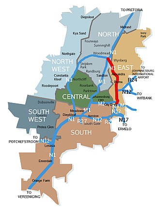
The N3 Eastern Bypass is a section of the Johannesburg Ring Road that forms a beltway around the city of Johannesburg, South Africa, as part of the N3. The first section of the freeway opened in 1971, from Buccleuch to the interchange with Main Reef Road in Germiston. This is one reason why Germiston is listed as the southbound destination of this route, from the Buccleuch to Geldenhuys Interchanges, rather than to the Elands Interchange south of Germiston. The remaining section from Main Reed Road to Black Reef Road, which included the construction of the Geldenhuys Interchange, was opened in 1977, linking the Eastern Bypass with the N3 freeway to Heidelberg. The interchange at Main Reef Road was removed.

<span class="mw-page-title-main">N1 Western Bypass (Johannesburg)</span> Road in South Africa

The Western Bypass is a section of the N1 and the Johannesburg Ring Road located in the city of Johannesburg, South Africa. Known at the time as the Concrete Highway, the freeway was initially opened in 1975 as a route to avoid the city centre of Johannesburg and to provide access to the western areas of the Witwatersrand. From the south, the Western Bypass begins at the Diepkloof Interchange in Soweto, where it splits from the N12 freeway and ends at the Buccleuch Interchange, where it merges with the N3 Eastern Bypass, M1 South and N1 Ben Schoeman freeways.

<span class="mw-page-title-main">N12 Southern Bypass (Johannesburg)</span> Road in South Africa

The N12 Southern Bypass is a section of the Johannesburg Ring Road that forms a beltway around the city of Johannesburg, South Africa, as part of the N12. The freeway was the last section of the Ring Road to be built, with the final section opening in 1986. As part of the old South African Freeways, It was initially called the N13. The entire Southern Bypass freeway was an e-toll highway from 3 December 2013 to 11 April 2024.

<span class="mw-page-title-main">N1 (South Africa)</span> National road in South Africa

The N1 is a national route in South Africa that runs from Cape Town through Bloemfontein, Johannesburg, Pretoria and Polokwane to Beit Bridge on the border with Zimbabwe. It forms the first section of the famed Cape to Cairo Road.

<span class="mw-page-title-main">R21 (South Africa)</span> Road in South Africa

The R21 is a major north–south provincial route in eastern Gauteng Province, South Africa. Built in the early 1970s, it remains one of two freeways linking Pretoria with Johannesburg, via the R24. As the eastern of the two freeways, it links the Pretoria city centre with OR Tambo International Airport and Boksburg. Between the Solomon Mahlangu Drive on-ramp in Monument Park, Pretoria, and the N12 interchange in Boksburg, the R21 is an 8 lane highway and motorway (freeway), with 4 lanes in each direction. It has off-ramps leading to Irene, Olifantsfontein, Benoni, and Kempton Park. The route intersects the N1 highway near Centurion, the R24 near the airport, the N12 and N17 in Boksburg, and the N3 near Vosloorus on the East Rand, where it ends. The section from the N12 to the N3 is not a freeway. The R21 is also designated as the P157.

<span class="mw-page-title-main">R23 (South Africa)</span> Road in South Africa

The R23 is a provincial route in South Africa that links Benoni with Volksrust via Brakpan, Heidelberg and Standerton.

<span class="mw-page-title-main">R24 (South Africa)</span> Road in South Africa

The R24 is a major East-West provincial route in the Gauteng and North West provinces that links OR Tambo International Airport with Rustenburg via Johannesburg, Krugersdorp and Magaliesburg. The process of renaming the streets and freeway that form the route from Krugersdorp eastward to OR Tambo International after anti-apartheid stalwart Albertina Sisulu was completed in 2013.

<span class="mw-page-title-main">R54 (South Africa)</span>

The R54 is a provincial route in South Africa that connects Potchefstroom with Villiers via Vereeniging.

<span class="mw-page-title-main">R55 (South Africa)</span> Road in South Africa

The R55 is a north-south provincial route in Gauteng, South Africa that connects Sandton with Pretoria. It passes Woodmead, Kyalami, Olievenhoutbosch, Heuweloord, Sunderland Ridge, Erasmia, Laudium/Claudius, West Park, the Daspoort Tunnel and Danville. It connects with the M1, N14, and R80 highways. It is also designated as the P66-1 and K71 by the Gauteng Provincial Government.

The R103 is a Regional Route in South Africa that is the designation for some of the old sections of roads that were previously the N3, prior to upgrading. It only has 3 sections, from Hillcrest to Ladysmith, from Warden to Villiers and from Heidelberg to Johannesburg.

The M1 De Villiers Graaff motorway is a metropolitan route and major freeway in the City of Johannesburg, South Africa. The highway connects the southern areas with the city centre and extends further north through Sandton into the Ben Schoeman Highway towards Pretoria. Construction began in 1962 and resulted in the demolition of many properties and houses including numerous historical Parktown Mansions.

The M2 is a major highway and metropolitan route in Greater Johannesburg, South Africa. It is named the Francois Oberholzer Freeway. It runs just to the south of the Johannesburg Central Business District eastwards where it connects with the N3 and enters Germiston, ending near its CBD. The north–south M1 intersects with the M2 just to the south-west of the Johannesburg CBD.

<span class="mw-page-title-main">N12 (South Africa)</span> National road in South Africa

The N12 is a national route in South Africa which runs from George through Beaufort West, Kimberley, Klerksdorp and Johannesburg to eMalahleni.

<span class="mw-page-title-main">N4 (South Africa)</span> National road in South Africa

The N4 is a national route in South Africa that runs from Skilpadshek on the Botswana border, past Rustenburg, Pretoria, eMalahleni and Mbombela, to Komatipoort on the Mozambique border. The entire route is a toll road.

The M13 is a metropolitan route in the Ethekwini Metropolitan Municipality in the KwaZulu-Natal province of South Africa. For most of its route, it is a highway named King Cetshwayo Highway and it acts as an alternative route to the N3 highway for travel between the suburbs closer to the Durban CBD and the Outer West Suburbs (Assagay).

<span class="mw-page-title-main">N17 (South Africa)</span> National road in South Africa

The N17 is a national route in South Africa which runs from Johannesburg to Oshoek (Ngwenya) on the border with Eswatini. It passes through Springs, Bethal and Ermelo.

<span class="mw-page-title-main">Ben Schoeman Freeway</span> Road in South Africa

The Ben Schoeman Freeway or Ben Schoeman Highway is the main freeway between Johannesburg and Pretoria, and consists of portions of the M1, N1, and N14. Opened in 1968, it is named after former Minister of Transport Ben Schoeman, and is undoubtedly the busiest road in South Africa.

The R554 is a Regional Route in Gauteng, South Africa. The road connects the southern suburbs of Soweto with Springs on the East Rand via Lenasia, Alberton and Brakpan.

The M37 is a metropolitan route in Greater Johannesburg, South Africa. It connects the N3 at Greenstone Shopping Mall with Katlehong via Edenvale and Germiston.

References

  1. Falkner, John (May 2012). South African Numbered Route Description and Destination Analysis (Report). National Department of Transport. pp. 13–15. Archived from the original on 6 June 2014. Retrieved 12 August 2014.
  2. 1 2 "Home | N3 Toll Route" . Retrieved 23 July 2022.
  3. "Here are the streets affected by Ekurhuleni's new name changes". The Citizen. 13 October 2021. Retrieved 2 January 2022.
  4. "Busiest freeways in southern hemisphere". SA National Roads Agency. 26 September 2008. Archived from the original on 16 June 2013. Retrieved 15 July 2013.
  5. http://www.theheritageportal.co.za/sites/default/files/styles/adaptive/public/Department%20of%20Transport%20Map%20South%20Africa%201959.jpg?itok=TncXhikX [ bare URL image file ]
  6. 1 2 "N3 route to be shortened" . Retrieved 10 September 2008.
  7. "SANRAL cancels de Beers Pass Route construction plans".
  8. https://www.nra.co.za/live/content.php?Item_ID=5217 [ dead link ]
  9. "Alternative options across Drakensberg to be considered". pressoffice.mg.co.za. Retrieved 1 May 2024.
  10. "N3 Toll Road Sections". Archived from the original on 24 September 2006.
  11. "E-tolls going live in Gauteng". fin24.com. 20 November 2013. Retrieved 22 August 2014.
  12. South African Government ends e-tolls in Gauteng press release published 28th of March 2024, retrieved and archived 5th of April 2024
  13. Njilo, Nonkululeko (10 April 2024). "Gauteng set to finally end e-tolls, overdue fees remain". Daily Maverick. Retrieved 12 April 2024.
  14. Fraser, Luke (28 March 2024). "E-tolls to officially end next month". BusinessTech. Retrieved 12 April 2024.
  15. Liebenberg, Dries (9 May 2000). "Polisievrou séker sy sien vreemde lig". Beeld. p. 3.

28°18′56″S29°11′56″E / 28.315678°S 29.198914°E / -28.315678; 29.198914