Hillcrest, KwaZulu-Natal

Last updated
Hillcrest
South Africa KwaZulu-Natal location map.svg
Red pog.svg
Hillcrest
South Africa adm location map.svg
Red pog.svg
Hillcrest
Coordinates: 29°46′48″S30°45′46″E / 29.78000°S 30.76278°E / -29.78000; 30.76278
Country South Africa
Province KwaZulu-Natal
Municipality eThekwini
Established22 January 1895
Government
   Ward Councillor Rick Crouch [1] [2] [3] (Democratic Alliance)
Area
[4]
  Total21.44 km2 (8.28 sq mi)
Population
 (2011) [4]
  Total13,329
  Density620/km2 (1,600/sq mi)
Racial makeup (2011)
[4]
   Black African 11.4%
   Coloured 0.8%
   Indian/Asian 3.0%
   White 84.3%
  Other0.6%
First languages (2011)
[4]
   English 82.7%
   Afrikaans 7.6%
   Zulu 6.9%
  Other2.9%
Time zone UTC+2 (SAST)
Postal code (street)
3610
PO box
3650
Area code 031

Hillcrest is a town in the KwaZulu-Natal province of South Africa that forms part of the eThekwini Metropolitan Municipality and is situated approximately 32 km (20 mi) north-west of Durban and 53 km (33 mi) south-east of Pietermaritzburg.

Contents

History

Hillcrest was formerly a sleepy village, governed by its own Town Board [5] on the outskirts of Durban that has now become a booming suburb incorporated into the eThekwini Metropolitan Municipality. Hill Crest (as the town's name was variously spelt until 1969) was founded on a rise in the main road from Durban to Pietermaritzburg in 1895 as a farming or "weekend" village, then a good distance from what was the emerging port of Port Natal. The village was laid out as leasehold sites on a portion of the farm Albinia owned by William Gillitt, one of the main pioneer families of the area and after which the nearby suburb of Gillitts is named.

One of the other early families to set up in the area was the Acutts who had already established the well known in Durban estate agents firm of that name. In 1903 the first school in the village was established in a wood and iron cottage in Hospital Road leased to a Mrs McMillian, the principal of the first Highbury School, by Horace Acutt.

When the first Hillcrest Health Committee was established in 1943, the total all-race population was 1135 persons and only the Main Road was hardened. Nkutu Road was hardened with klinker in 1947 and this was followed in 1951 with the hardening of the first portion of Inanda Road. In 1962 blacktopping of selected roads in the central area began, followed by further roads in 1965. By 1971, when Town Board status was obtained, the total population had grown to 2799 persons.

The Hillcrest Waste Water Treatment Plant was established in the 1990s, then serving only the central commercial area of the village with phased extensions planned in time, with other areas continuing on septic tanks.

Prior to 1 December 2023, vehicle registration plates in Hillcrest started with NU - N for Natal, U for Upper Highway which covered the suburbs within the Upper Highway Area such as Kloof, Gillitts, Botha's Hill, Assagay, Waterfall and Everton as well as New Germany and Queensburgh just outside the Upper Highway.

Hillcrest today

Hillcrest lost its independent Town Board status in 1996 and was made subject to administration by the Outer West Local Council - a substructure council of the then Durban Unicity. In 2000, the Outer West Local Council, along with other local councils, was disestablished and were replaced by the single eThekwini Municipality encompassing the entire Durban metropolitan area.

With rural origins, Hillcrest has been swept up in Durban's urban sprawl and experienced a building boom in the late 1990s and 2000s with the construction of many shopping centres and gated communities such as Cotswold Downs, Camelot and Plantations. [6]

View of Inanda Road in Hillcrest Hillcrest View.jpg
View of Inanda Road in Hillcrest

Geography

Hillcrest is situated in the Upper Highway Area of Durban, approximately 32 kilometres (20 mi) north-west of the city and is bordered by Gillitts and Everton to the east, Waterfall to the north-east and Botha's Hill and Assagay to the north-west. It lies at an altitude of approximately 680 m (2231 ft) above sea level in the Valley of a Thousand Hills, just above Durban.

Suburban areas

Source: [7]

Retail

Old Main Road is the main retail thoroughfare of the central business district, lined by a number of local shops, restaurants and shopping centres such as Hillcrest Corner, which is the largest in Hillcrest, Christians Village, The Colony, Hillgate, Hillcrest Centre, Lillies Quarter and Oxford Village Centre. [8] [9]

Infrastructure

Education

A public school system is provided in Hillcrest including Hillcrest High School and Hillcrest Primary School, [10] [11] with Winston Park Primary School in nearby Winston Park.

Private schools include Highbury Preparatory School, Curro: HCA and Waterfall Schools with Kearsney College and the Roseway Waldorf School in nearby Botha's Hill and Alverstone respectively.

Healthcare

Hillcrest is served by two hospitals, namely the Hillcrest Hospital, a specialised public hospital for chronically ill patients and the Busamed Hillcrest Private Hospital, owned by major South African private health group, Busamed, located just outside Hillcrest. [12] [13]

Transport

Roads

Hillcrest lies just off the M13 (King Cetshwayo Highway) heading south-east to Durban (via Gillitts, Kloof, Pinetown and Westville) and the N3 (Mariannhill Toll Route) connecting Durban and Pietermaritzburg.

However, the main route through the town is the R103 (Old Main Road) which heads north-west to Botha’s Hill and Inchanga, forming part of the old main road between Durban and Pietermaritzburg. Heading north-west, the M33 (Inanda Road) connects to Waterfall. Heading south-west, the M46 (Kassier Road) connects to Assagay and Shongweni.

Notable residents

Related Research Articles

<span class="mw-page-title-main">Kearsney College</span> All-boys private school in Bothas Hill, KwaZulu-Natal, South Africa

Kearsney College is a private boarding, English medium high school for boys in Botha's Hill, a small town between the provincial capital of Pietermaritzburg and Durban, in the KwaZulu-Natal province of South Africa.

<span class="mw-page-title-main">Kloof</span> Place in KwaZulu-Natal, South Africa

Kloof is a town that includes a smaller area called Everton, located approximately 26 km north-west of Durban in KwaZulu-Natal, South Africa. Once an independent municipality, it now forms part of greater Durban area of the eThekwini Metropolitan Municipality.

Pinetown is a city that forms part of the eThekwini Metropolitan Municipality, based just inland from Durban in KwaZulu-Natal, South Africa. The town is situated 16 km north-west of Durban and 64 km south-east of Pietermaritzburg.

Queensburgh is a town in KwaZulu-Natal, South Africa that is situated inland (southwest) from Durban and now forms part of eThekwini, the Greater Durban metropolitan area.

Westville is an area in KwaZulu-Natal, South Africa, and is just west and 10 km inland from the Durban CBD. It was a formerly independent municipality however it became part of the eThekwini Metropolitan Municipality in 2002.

oThongathi Place in KwaZulu-Natal, South Africa

oThongathi, previously and still commonly known as Tongaat, is a town in KwaZulu-Natal, South Africa, about 40 kilometres (25 mi) north of Durban and 28 kilometres (17 mi) south of KwaDukuza. It now forms part of eThekwini Metropolitan Municipality, or the Greater Durban area. The area is home to the oldest Indian community in South Africa, having been where the first indentured Indian laborers settled in 1860 to work in the sugar-cane plantations. Much of the architectural style in the town was the work of Ivan Mitford-Barberton, and many buildings are in the Cape Dutch style of architecture.

<span class="mw-page-title-main">Valley of a Thousand Hills</span> Place in KwaZulu-Natal, South Africa

The Valley of a Thousand Hills is a valley between Pietermaritzburg and Durban, South Africa. The Umgeni River meets the Msunduzi River in the valley, and the Dusi Canoe Marathon is run through the area every year.

<span class="mw-page-title-main">Botha's Hill</span> Place in KwaZulu-Natal, South Africa

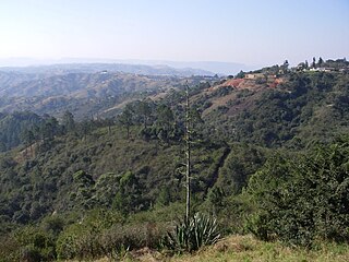
Botha's Hill is a small town outside Hillcrest in KwaZulu-Natal, South Africa. It remains a peaceful beautiful hill where regular country style food and craft markets are held. It is the gateway to the Valley of a Thousand Hills. Kearsney College moved to Botha's Hill in 1939. Alan Paton, the author of Cry, the Beloved Country and Too Late the Phalarope lived here until his death on 12 April 1988.

Gillitts is a town in the KwaZulu-Natal Province of South Africa.

<span class="mw-page-title-main">Liege Hulett</span>

Sir James Liege Hulett was a British sugar magnate, politician and philanthropist in Colony of Natal, South Africa. Hulett founded what would become Tongaat Hulett Sugar in 1892. The JSE Securities Exchange-listed company is today a multi-billion rand corporation.

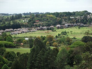
The Upper Highway Area is a region west of the city of Durban in KwaZulu-Natal, South Africa. It is the suburban western part of the Greater Durban metropolitan area and extends from Kloof in the east to Botha’s Hill in the west. It includes the main towns of Hillcrest, Gillitts and Kloof and the smaller areas of Assagay, Botha’s Hill, Everton and Waterfall.

The M13 is a metropolitan route in the Ethekwini Metropolitan Municipality in the KwaZulu-Natal province of South Africa. For most of its route, it is a highway named King Cetshwayo Highway and it acts as an alternative route to the N3 highway for travel between the suburbs closer to the Durban CBD and the Outer West Suburbs (Assagay).

Assagay, also spelt Assegay, is a suburb of eThekwini in KwaZulu-Natal, South Africa and forms a part of the Upper Highway Area.

<span class="mw-page-title-main">Umgeni Steam Railway</span> Worlds OLDEST RAILWAY TUNNEL

The Umgeni Steam Railway is a 3 ft 6 in gauge heritage railway at Inchanga, near Durban. The Durban to Pietermaritzburg line was built in the 1880s; it runs through a 53 metres (174 ft) long tunnel at Drummond built in 1878, which is probably the oldest tunnel in use today in South Africa

<span class="mw-page-title-main">Inanda FM</span> Radio station

Inanda 88.4 is a South African Community radio station situated in Inanda, KwaZulu-Natal, which broadcasts in English and Zulu to most of the KwaZulu Natal, province. As of November 2010, The station boasts an audience of more than 102,000

Mpumalanga, also widely known as Hammarsdale, is a township located in the eThekwini Metropolitan Municipality in the KwaZulu-Natal province of South Africa. It is situated some 10 km south-south-east of Cato Ridge and some 50 km west of Durban. Derived from Zulu, the name means 'sunrise', 'the sun comes out'.

KwaDabeka is a township in KwaZulu-Natal, South Africa, located north-west of Durban and means "at the Dabeka location".

Waterfall is a small residential area that lies north-east of Hillcrest in the province of KwaZulu-Natal, South Africa. Although Waterfall is officially regarded as a separate suburb from Hillcrest, it is often locally regarded as something of an extension of Hillcrest.

References

  1. "Councillor ready to tackle problems hands-on" . Retrieved 2011-07-09.[ dead link ]
  2. Independent Electoral Commission - 2011 Election Results
  3. Ward 10 - Official Ward 10 Councillor Web Site
  4. 1 2 3 4 "Main Place Hillcrest". Census 2011.
  5. [ dead link ]
  6. Mullany, David (2007). "Hillcrest of a wave". The Property Magazine. Archived from the original on 2009-05-22.
  7. "Census 2011: Main Place: Hillcrest". census2011.adrianfrith.com. Retrieved 2023-03-10.
  8. "Home - Lillies Quarter". 2020-05-04. Retrieved 2023-04-17.
  9. "Hillcrest Corner | Simply Essential" . Retrieved 2023-04-17.
  10. "Hillcrest Primary School Website". HCPS. Retrieved 23 October 2014.
  11. "KZN primary school gets top marks for technology adoption". www.itweb.co.za. IT Web. 14 November 2012. Retrieved 5 November 2014.
  12. "Busamed Hillcrest". Busamed Hillcrest. Retrieved 2023-03-10.
  13. "Hillcrest Hospital". www.kznhealth.gov.za. Retrieved 2023-03-10.
  14. "Heather Hamilton: Who's Who SA". Who's Who SA. Archived from the original on 2014-11-05. Retrieved 2014-11-05.
  15. Tongaat Hulletts history

Sources