KwaZulu-Natal is a province of South Africa that was created in 1994 when the Zulu bantustan of KwaZulu and Natal Province were merged. It is located in the southeast of the country, with a long shoreline on the Indian Ocean and sharing borders with three other provinces and the countries of Mozambique, Eswatini and Lesotho. Its capital is Pietermaritzburg, and its largest city is Durban. It is the second-most populous province in South Africa, with slightly fewer residents than Gauteng.

Durban, nicknamed Durbs, is the third most populous city in South Africa after Johannesburg and Cape Town and the largest city in KwaZulu-Natal. Durban forms part of the eThekwini Metropolitan Municipality, which includes neighbouring towns and has a population of about 3.44 million, making the combined municipality one of the largest cities on the Indian Ocean coast of the African continent. Durban was also one of the host cities of the 2010 FIFA World Cup.
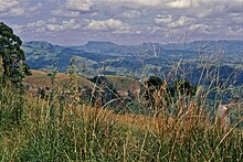
Howick is a town located in the UMngeni Local Municipality of KwaZulu-Natal Province, South Africa. The town is 1050 m above sea level, and about 88 kilometres from the port city of Durban. It enjoys warm summers and cool dry winters. A snappy chill descends upon Howick when snow falls on the nearby Drakensberg. The town is located on the N3 freeway, connecting it with the rest of South Africa.

Ezemvelo KZN Wildlife is a governmental organisation responsible for maintaining wildlife conservation areas and biodiversity in KwaZulu-Natal Province, South Africa. Their headquarters is in Queen Elizabeth Park situated on the northern slopes of Pietermaritzburg, the KwaZulu-Natal provincial capital. Prior to 1994, it was known as the Natal Parks Board.

Kloof is a leafy upper-class town, that includes a smaller area called Everton, located approximately 26 km north-west of Durban in KwaZulu-Natal, South Africa. Once an independent municipality, it now forms part of greater Durban area of the eThekwini Metropolitan Municipality.
Pinetown is a city that forms part of the eThekwini Metropolitan Municipality, based just inland from Durban in KwaZulu-Natal, South Africa. The town is situated 16 km north-west of Durban and 64 km south-east of Pietermaritzburg.
Westville is an area in KwaZulu-Natal, South Africa, and is just west and 10 km inland from the Durban CBD. It was a formerly independent municipality however it became part of the eThekwini Metropolitan Municipality in 2002.

Verulam is a town 24 kilometres north of Durban in KwaZulu-Natal, South Africa and forms part of the eThekwini Metropolitan Municipality, governing the Greater Durban metropolitan area.

The Umgeni River or Mgeni River is a river in KwaZulu-Natal, South Africa. It rises in the "Dargle" in the KZN Midlands, and its mouth is at Durban, some distance north of Durban's natural harbour. It is generally agreed its name means "the river of entrance" in Zulu, though other meanings have been suggested.
Gillitts is a town in the KwaZulu-Natal Province of South Africa.

Durban North is an area to the north of Durban in the eThekwini Metropolitan Municipality, KwaZulu-Natal, South Africa. Durban North lies between the N2 freeway and the eastern seashore, with the Umgeni River forming its southern boundary. It has residential suburbs that are some of Durban's most affluent and is flanked by La Lucia in the north.
The M13 or King Cetshwayo Highway is a metropolitan route in the Ethekwini Metropolitan Municipality in the KwaZulu-Natal province of South Africa. For part of its route, it is a highway and it acts as an alternative route to the N3 Highway for travel between the suburbs closer to the Durban CBD and the Outer West Suburbs (Assagay).

The Umgeni Steam Railway is a 3 ft 6 in gauge heritage railway at Inchanga, near Durban. The Durban to Pietermaritzburg line was built in the 1880s; it runs through a 53 metres (174 ft) long tunnel at Drummond built in 1878, which is probably the oldest tunnel in use today in South Africa
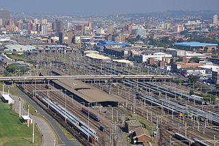
Durban railway station is the central railway station in the city of Durban, South Africa, located between Umgeni Road and Masabalala Yengwa Avenue just to the north of the central business district. It is the terminus of Shosholoza Meyl long-distance services from Johannesburg and Cape Town, and the hub of a network of Metrorail commuter rail services that stretch as far as KwaDukuza (Stanger) to the north, Kelso to the south, and Cato Ridge inland.
Mpumalanga, also widely known as Hammarsdale, is a township located in the eThekwini Metropolitan Municipality in the KwaZulu-Natal province of South Africa. It is situated some 10 km south-south-east of Cato Ridge and some 50 km west of Durban. Derived from Zulu, the name means 'sunrise', 'the sun comes out'.
Cato Ridge is a town in the KwaZulu-Natal province of South Africa named after George Christopher Cato (1814-1893), the first mayor of Durban. Organisationally and administratively it is included in the Ethekwini Metropolitan Municipality as a suburb of the Outer West region.
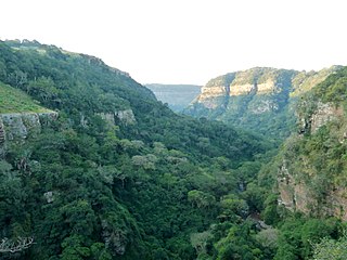
The Krantzkloof Nature Reserve, managed by Ezemvelo KZN Wildlife, conserves 668 ha of the Molweni and Nkutu River gorges that incise the sandstone Kloof plateau in KwaZulu-Natal, South Africa. The reserve conserves coastal scarp forest, sourveld grassland, a cliff face biotope, and aquatic environments along its rivers. Scarp forest is a threatened forest type, protected by South Africa's forests act of 1998, while the grassland is classified as KwaZulu-Natal sandstone sourveld, the most threatened terrestrial habitat in the Durban metropole. The reserve was established in 1950 and was augmented by land donations as late as 1999.

Umgeni Park is a residential area in northern Durban, KwaZulu-Natal, South Africa. Together with its neighbouring Durban North suburb of Athlone, the area is also known as Riverside, due to its location along the northern banks of the Umgeni River. The area is marked by its cluster developments and townhouse complexes, as well as free standing homes. On the western boundary of the suburb is the Briardene Informal Settlement and the Umgeni Park light industrial area.