
Woodhaven is a suburban city in southern Wayne County in the U.S. state of Michigan. As of the 2010 census, the city population was 12,875. It is part of a collection of 18 suburban communities known as Downriver.

Woodhaven is a middle-class neighborhood located in the central section of the New York City borough of Queens. It is bordered on the north by Park Lane South and Forest Park, on the east by Richmond Hill to the east, on the south by Ozone Park and Atlantic Avenue, and on the west by Brooklyn.
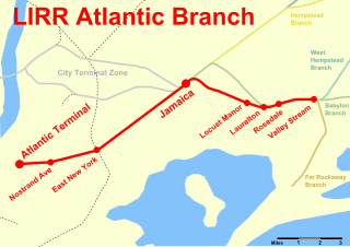
The Atlantic Branch is an electrified rail line owned and operated by the Long Island Rail Road in the U.S. state of New York. It is the only LIRR line that runs in the borough of Brooklyn.

Rockaway Boulevard is a station on the IND Fulton Street Line of the New York City Subway. Located at the intersection of Rockaway Boulevard, Woodhaven and Cross Bay Boulevards, and Liberty Avenue in Ozone Park, Queens, it is served by the A train at all times.

Woodhaven Boulevard is a local station on the IND Queens Boulevard Line of the New York City Subway, consisting of four tracks. Located in Elmhurst, Queens, it is served by the M train on weekdays, the R train at all times except nights, and the E train at night. The station serves the adjacent Queens Center Mall, as well as numerous bus lines.

Pennsylvania Route 63 is a 37.4-mile-long (60.2 km) state highway located in the Philadelphia, Pennsylvania area. The western terminus of the route is at PA 29 in Green Lane, Montgomery County. The eastern terminus is at Interstate 95 (I-95) in Bensalem Township, Bucks County. The route heads through a mix of suburban and rural areas of northern Montgomery County as a two-lane road, passing through Harleysville, before coming to an interchange with I-476 in Towamencin Township. From this point, PA 63 continues through predominantly suburban areas of eastern Montgomery County as a two- to four-lane road, passing through Lansdale, Maple Glen, Willow Grove, and Huntingdon Valley. Upon entering Northeast Philadelphia, the route follows Red Lion Road and U.S. Route 1 before heading southeast on a freeway called Woodhaven Road to I-95.
Woodhaven Boulevard and Cross Bay Boulevard are two parts of a major boulevard in the New York City borough of Queens. Woodhaven Boulevard runs roughly north–south in the central portion of Queens. South of Liberty Avenue, it is known as Cross Bay Boulevard, which is the main north–south road in Howard Beach. Cross Bay Boulevard is locally known as simply "Cross Bay", and Woodhaven Boulevard, "Woodhaven". The completion of the boulevard in 1923, together with the construction of the associated bridges over Jamaica Bay, created the first direct roadway connection to the burgeoning Atlantic Ocean beachfront communities of the Rockaway Peninsula from Brooklyn and most of Queens.

Jamaica Avenue is a major avenue in the New York City boroughs of Brooklyn and Queens, New York, in the United States. Jamaica Avenue's western end is at Broadway and Fulton Street, as a continuation of East New York Avenue, in Brooklyn's East New York neighborhood. Physically, East New York Avenue connects westbound to New York Avenue, where East New York Avenue changes names another time to Lincoln Road; Lincoln Road continues to Ocean Avenue in the west, where it ends. Its eastern end is at the city line in Bellerose, Queens, where it becomes Jericho Turnpike to serve the rest of Long Island. The section of Jamaica Avenue designated as New York State Route 25 runs from Braddock Avenue to the city line, where Jamaica Avenue becomes Jericho Turnpike.
The Queens Community Board 5 is a local government in the New York City borough of Queens, encompassing the neighborhoods of Ridgewood, Glendale, Middle Village, Maspeth, Fresh Pond, and Liberty Park. It is delimited by Maurice Avenue and the Long Island Expressway to the north, the Brooklyn borough line to the west and south, and Woodhaven Boulevard to the east.
The Queens Community Board 6 is the local government body in the New York City borough of Queens, encompassing the neighborhoods of Forest Hills and Rego Park. It is delimited by the Horace Harding Expressway to the north, Woodhaven Boulevard to the west, the Jackie Robinson Parkway to the south, and the Grand Central Parkway on the east.
The Queens Community Board 9 is a local government in the New York City borough of Queens, encompassing the neighborhoods of Richmond Hill, Woodhaven, Ozone Park and Kew Gardens. It is delimited by the Brooklyn border to the West, Park Lane and Union Turnpike to the North, Van Wyck Expressway to the East and 103rd Avenue on the South.
Woodhaven Junction was a station complex on the Atlantic Branch and Rockaway Beach Branch of the Long Island Rail Road, located at Atlantic Avenue between 98th and 100th Streets in Woodhaven, Queens, New York City. The elevated Rockaway Beach station was closed in 1962 along with the rest of the branch, while the underground Atlantic Branch station was closed and abandoned in 1976.
Woodhaven High School is a public high school in the township of Brownstown, and located within the Woodhaven-Brownstown School District. Located at 24787 Van Horn Road, Brownstown, MI, just West of Interstate 75. The school's mascot is the Warrior, and the school colors are purple and white. The current school population is 1,400. The school offers grades 10th through 12th. Woodhaven High School competes in the Downriver League: an athletic association consisting of Woodhaven and 9 other Downriver area high schools.
Normandy is a neighborhood in Northeast Philadelphia. It is located east of Roosevelt Boulevard, in the vicinity of Woodhaven and Byberry Roads, built in 1955- 1956. All of the streets in this neighborhood begin with the letter N. The neighborhood is made up of Cape Cod-style single-family homes, with frame construction. Most of the homes have received additions over the years. The original landowners were Joseph Buckman, who owned 73 acres (300,000 m2) and John Rieger, who owned 18 acres (73,000 m2). Kraft Foods currently operates the old Nabisco/Mondelez International plant at the southwest corner of Roosevelt Boulevard and Byberry Road. Devon Self-Storage occupies what used to be Best products, also what was the original Normandy Square market.
Woodhaven is a neighborhood at the corner of Interstate 30 and the Loop 820 East interchange in Fort Worth, Texas, United States. The neighborhood is bounded by the Trinity River to the north and the former CBS Channel 11 KTVT studios to the south. The Woodhaven Country Club, which has a clubhouse, a 6,543-yard, par 71, 18-hole golf course, a swimming pool, and tennis courts, is the center of the community.
Woodhaven is a former railroad and trolley station on the Atlantic Branch of the Long Island Rail Road. Though it was also on one of the same lines as Woodhaven Junction the two stations were distinguished from one another. Woodhaven was located on Atlantic Avenue, east of 87th Street.
Ridgewood was a train station along the Lower Montauk Branch of the Long Island Rail Road, located at Woodhaven Boulevard near 78th Avenue in Ridgewood, Queens, just east of Glendale Junction, the connecting track between the Montauk Branch and Rockaway Beach Branch. It opened on June 2, 1883 and closed in 1924.

The Q11, Q21, Q52, and Q53 bus routes constitute a public transit corridor running along Woodhaven and Cross Bay Boulevards in Queens, New York City, United States. The corridor extends primarily along the length of the two boulevards through "mainland" Queens, a distance of 6 miles (9.7 km) between Elmhurst and the Jamaica Bay shore in Howard Beach. The Q52 and Q53 buses, which provide Select Bus Service along the corridor, continue south across Jamaica Bay to the Rockaway peninsula, one of the few public transit options between the peninsula and the rest of the city.


