
George V was King of the United Kingdom and the British Dominions, and Emperor of India, from 6 May 1910 until his death in 1936.

South Africa is divided into nine provinces. On the eve of the 1994 general election, South Africa's former homelands, known as Bantustans, were reintegrated into the country, and the four provinces were increased to nine by dividing Cape Province and the Transvaal into three and four, respectively. The twelfth, thirteenth and sixteenth amendments to the Constitution of South Africa changed the borders of seven of the provinces.

The Albert Memorial, directly north of the Royal Albert Hall in Kensington Gardens, London, was commissioned by Queen Victoria in memory of her beloved husband Prince Albert, who died in 1861. Designed by Sir George Gilbert Scott in the Gothic Revival style, it takes the form of an ornate canopy or pavilion 176 feet (54 m) tall, in the style of a Gothic ciborium over the high altar of a church, sheltering a statue of the prince facing south. It took over ten years to complete, the £120,000 cost met by public subscription.
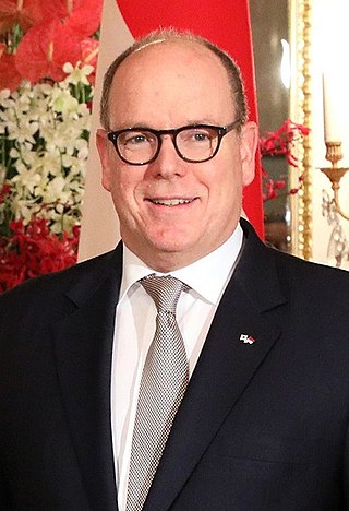
Albert II is Prince of Monaco, reigning since 2005.

Prince Albert is the third-largest city in Saskatchewan, Canada, after Saskatoon and Regina. It is situated near the centre of the province on the banks of the North Saskatchewan River. The city is known as the "Gateway to the North" because it is the last major centre along the route to the resources of northern Saskatchewan. Prince Albert National Park is located 51 km (32 mi) north of the city and contains a wealth of lakes, forest, and wildlife. The city itself is located in a transition zone between the aspen parkland and boreal forest biomes. Prince Albert is surrounded by the Rural Municipality of Prince Albert No. 461, of which it is the seat, but is politically separate.

Prince Albert National Park encompasses 3,874 square kilometres (1,496 sq mi) in central Saskatchewan, Canada and is located 200 kilometres (120 mi) north of Saskatoon. Though declared a national park March 24, 1927, official opening ceremonies weren't performed by Prime Minister William Lyon Mackenzie King until August 10, 1928. This park is open all year but the most visited period is from May to September. Although named for the city of Prince Albert, the park's main entrance is actually 80 km (50 mi) north of that city via Highways 2 and 263, which enters the park at its southeast corner. Two additional secondary highways enter the park, Highway 264, which branches off Highway 2 just east of the Waskesiu townsite, and Highway 240, which enters the park from the south and links with 263 just outside the entry fee-collection gates. Prince Albert National Park is not located within any rural municipality, and is politically separate from the adjacent Northern Saskatchewan Administration District (NSAD). Until the establishment of Grasslands National Park in 1981, it was the province's only national park.

Benoni is a town on the East Rand, Gauteng, South Africa, some 26 kilometres (16 mi) east of Johannesburg, within the City of Ekurhuleni municipality.

Prince Albert Municipality is a local municipality located in the Western Cape province of South Africa.

The Central Karoo District Municipality is a district municipality located in the Western Cape province of South Africa. Its municipality code is DC5.

The Swartberg mountains are a mountain range in the Western Cape province of South Africa. It is composed of two main mountain chains running roughly east–west along the northern edge of the semi-arid Little Karoo. To the north of the range lies the other large semi-arid area in South Africa, the Great Karoo. Most of the Swartberg Mountains are above 2000 m high, making them the tallest mountains in the Western Cape. It is also one of the longest, spanning some 230 km from south of Laingsburg in the west to between Willowmore and Uniondale in the east. Geologically, these mountains are part of the Cape Fold Belt.
The R328 is a Regional Route in Western Cape, South Africa that connects Mossel Bay in the south to Prince Albert in the north via Oudtshoorn.

The Chief Maqoma Regiment is a reserve infantry regiment of the South African Army. The regiment is located in the city of Port Elizabeth.

Charlene is Princess of Monaco as the wife of Prince Albert II. Before her marriage, Charlene was an Olympic swimmer.
Nova Scotia Trunk 7 is part of the Canadian province of Nova Scotia's system of Trunk Highways. The route runs from Bedford to Antigonish, along the Eastern Shore for a distance of 269 kilometres (167 mi). Part of Trunk 7 is known as the Marine Drive.
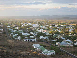
Prince Albert is a small town in the Western Cape in South Africa. It is located on the southern edge of the Great Karoo, at the foot of the Swartberg mountains. In recent years the moniker the "Franschhoek of the Karoo" has been used to describe the town's appeal to the art community and wealthier South Africans, many of whom have become residents of the town.

The Northern Woods and Water Route is a 2,400-kilometre (1,500 mi) route through northern British Columbia, Alberta, Saskatchewan and Manitoba in Western Canada. As early as the 1950s, community groups came together to establish a northern travel route; this was proposed as the Northern Yellowhead Transportation Route. The Northern Woods and Water Route Association was established in 1974, and encouraged promotion of the route with the promise of an increase in tourist travel. The route was designated in 1974 and is well signed throughout its component highways. The route starts at Dawson Creek as the Spirit River Highway and ends at the Perimeter of Winnipeg, Manitoba, after running through the northern regions of the western provinces. From west to east, the Northern Woods and Water Route (NWWR) incorporates portions of British Columbia Highway 49; Alberta Highways 49, 2A, 2, & 55; Saskatchewan Highways 55 & 9; Manitoba Provincial Road 283 and Trunk Highways 10, 5, 68 & 6. The halfway point of the NWWR is approximately at Goodsoil, Saskatchewan.
Highway 12 is a major highway in the Canadian province of Saskatchewan. It begins in Saskatoon at the intersection of Idylwyld Drive and Highway 11 north, initially running north on Idylwyld Drive concurrently with Highway 11 and Highway 16. Just outside Saskatoon's northern city limits, Highway 11 exits northeast from Idylwyld Drive and Highway 12 begins and travels north, passing through the city of Martensville. Highway 12 cross the North Saskatchewan River over Petrofka Bridge and passes through the town of Blaine Lake and intersects highway Highway 40, finally terminating at Highway 3 near Shell Lake. Highway 12 is about 135 km (84 mi) long.
Prince Albert Transit provides local city bus service in the City of Prince Albert, Saskatchewan, Canada.
Prince Albert Road is a village located in Laingsburg Local Municipality, Western Cape.
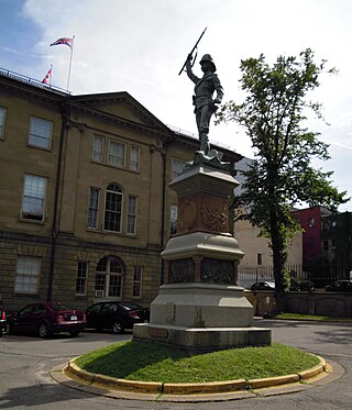
The South African War Memorial is a memorial located in the courtyard of Province House in Halifax, Nova Scotia, Canada.

