
Lake Tana is the largest lake in Ethiopia and a source of the Blue Nile. Located in Amhara Region in the north-western Ethiopian Highlands, the lake is approximately 84 kilometres long and 66 kilometres wide, with a maximum depth of 15 metres, and an elevation of 1,788 metres. Lake Tana is fed by the Gilgel Abay, Reb and Gumara rivers. Its surface area ranges from 3,000 to 3,500 square kilometres, depending on season and rainfall. The lake level has been regulated since the construction of the control weir where the lake discharges into the Blue Nile. This controls the flow to the Blue Nile Falls and hydro-power station.

Lake Victoria is one of the African Great Lakes. With a surface area of approximately 59,947 km2 (23,146 sq mi), Lake Victoria is Africa's largest lake by area, the world's largest tropical lake, and the world's second-largest fresh water lake by surface area after Lake Superior in North America. In terms of volume, Lake Victoria is the world's ninth-largest continental lake, containing about 2,424 km3 (1.965×10⁹ acre⋅ft) of water. Lake Victoria occupies a shallow depression in Africa. The lake has an average depth of 40 m (130 ft) and a maximum depth of 80–81 m (262–266 ft). Its catchment area covers 169,858 km2 (65,583 sq mi). The lake has a shoreline of 7,142 km (4,438 mi) when digitized at the 1:25,000 level, with islands constituting 3.7% of this length.

The Zambezi is the fourth-longest river in Africa, the longest east-flowing river in Africa and the largest flowing into the Indian Ocean from Africa. Its drainage basin covers 1,390,000 km2 (540,000 sq mi), slightly less than half of the Nile's. The 2,574 km (1,599 mi) river rises in Zambia and flows through eastern Angola, along the north-eastern border of Namibia and the northern border of Botswana, then along the border between Zambia and Zimbabwe to Mozambique, where it crosses the country to empty into the Indian Ocean.

The Orange River is a river in Southern Africa. It is the longest river in South Africa. With a total length of 2,432 km (1,511 mi), the Orange River Basin extends from Lesotho into South Africa and Namibia to the north. It rises in the Drakensberg mountains in Lesotho, flowing westwards through South Africa to the Atlantic Ocean. The river forms part of the international borders between South Africa and Lesotho and between South Africa and Namibia, as well as several provincial borders within South Africa. Except for Upington, it does not pass through any major cities. The Orange River plays an important role in the South African economy by providing water for irrigation and hydroelectric power. The river was named the Orange River in honour of the Dutch ruling family, the House of Orange, by the Dutch explorer Robert Jacob Gordon. Other names include simply the word for river, in Khoekhoegowab orthography written as !Garib, which is rendered in Afrikaans as Gariep River with the intrusion of a velar fricative in place of the alveolar click, Groote River or Senqu River, derived from ǂNū "Black". It is known in isiZulu as isAngqu.
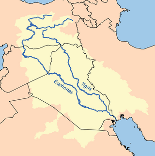
The Tigris–Euphrates river system is a large river system in Western Asia that discharges into the Persian Gulf. Its principal rivers are the Tigris and Euphrates, along with smaller tributaries.

The Sudd is a vast swamp in South Sudan, formed by the White Nile's Baḥr al-Jabal section. The Arabic word sudd is derived from sadd, meaning "barrier" or "obstruction". The term "the sudd" has come to refer to any large solid floating vegetation island or mat. The area which the swamp covers is one of the world's largest wetlands and the largest freshwater wetland in the Nile Basin.

The Neretva, also known as Narenta, is one of the largest rivers of the eastern part of the Adriatic basin. Four hydroelectric power plants with large dams provide flood protection, electicity and water storage. The Neretva is recognized for its natural environment and diverse landscapes.
The Pärnu is a river in Estonia. It drains into Pärnu Bay, which is an inlet of the Gulf of Riga. At 144 km, it is one of the longest rivers in Estonia, with a basin area of 6,920 km2 and an average discharge of 64.4 m³/s.

Southwestern Sri Lanka rivers and streams is a freshwater ecoregion in Sri Lanka. The ecoregion is listed in Global 200, a list of ecoregions compiled by the World Wide Fund for Nature for conservation priorities. The extensive network of rivers and streams of Sri Lanka drains a total of 103 distinct natural river basins. Several waterfall habitats have been formed as a result of rivers and streams flowing through high and mid elevation areas. The ecoregion spreads over 15,500 km2 in the wet zone of the southwestern part of Sri Lanka. More than a quarter of the freshwater fishes that have been discovered in Southwestern Sri Lanka rivers and streams are endemic. Nine endemic genera of freshwater fishes of Western Ghats and Sri Lanka hotspot Malpulutta are found only in Sri Lanka. Studies suggest that the number of species still to be discovered is quite high. Until recently wetlands in Sri Lanka were used for drainage, construction sites and land fills.

The Sonny Bono Salton Sea National Wildlife Refuge is located in the Imperial Valley of California, 40 miles (64 km) north of the Mexican border. Situated at the southern end of the Salton Sea, the refuge protects one of the most important nesting sites and stopovers along the Pacific Flyway. Despite its location in the Colorado Desert, a subdivision of the larger Sonoran Desert, the refuge contains marine, freshwater, wetland, and agricultural habitats which provide sanctuary for hundreds of birds and wetland species, including several that have been listed as endangered or sensitive by the U.S. Fish and Wildlife Service.
Boskop Dam is an earth-fill type dam on the Mooi River, near Potchefstroom, North West Province, South Africa. It was constructed in 1959. The main purpose of the dam is for irrigation and domestic usage. Its hazard potential is ranked as high, due to poor maintenance and the development of sink holes.
Klerkskraal Dam is a combined gravity and arch type dam located on the Mooi River, near Ventersdorp, North West, South Africa. It was established in 1969 and its main purpose is to serve for irrigation. The hazard potential of the dam has been ranked high (3). The dam is also a well known bass fishing destination in the region.
Klipdrif Dam is an earth-fill type dam located on the Loopspruit and Enselspruit near Potchefstroom, North West, South Africa. The river flowing out the dam is the Loopspruit. It was established in 1990 and its primary purpose is to serve for irrigation. The hazard potential of the dam has been ranked significant (2).

The Marico River or Madikwe is a river in Southern Africa. There are a number of dams in its basin. Groot Marico town is named after the Marico River. After it is joined on its right bank by the Crocodile River it is known as the Limpopo River.

The Notwane River is a river in southeastern Botswana. Certain sections of its course form the international boundary with South Africa. Its mouth is at the head of the Limpopo River. It has a catchment area of 18,053 square kilometers.
The Mooi River is a river in North West Province, South Africa. It is a tributary of the Vaal River and belongs to the Upper Vaal Water Management Area.
Gerhardminnebron is a natural karst spring located a few kilometers east of Ventersdorp in South Africa and draining into the Wonderfonteinspruit and Mooi River, which in turn flows into the Vaal River. It yields some 60 000 – 80 000 cubic meters of water per day, and is affected by exploitation and pollution by the gold mining industry in the region, deep–level gold mining having markedly impacted on the dolomitic aquifers. This spring is located in dolomitic rock that is part of the larger Boskop–Turffontein dolomite compartment in the Transvaal Basin. Dolomite is a sedimentary carbonate rock, a swath of which runs parallel to the Magaliesberg, and has a tendency to form large underground lakes and reservoirs.
Donaldson Dam is a dam next to the township Bekkersdal along the Wonderfonteinspruit. It comprises 2 reservoirs - the Top lake and the Bottom lake. Its water has been heavily polluted by acid mine runoff on the upper Wonderfonteinspruit and sewage from nearby Bekkersdal.

Lake Kanyaboli is the largest oxbow lake in Kenya and the second largest in Africa,formed after River Yala disconnected from its course at the meander stage, leaving behind a U-shaped lake. The lake is found in Siaya County in western Kenya and is home to a variety of fish species that have almost disappeared from Lake Victoria, the country's largest freshwater lake.
Caño Tiburones is a wetland and nature reserve located in the northern coast of Puerto Rico in the municipalities of Arecibo and Barceloneta. This is one of the largest wetlands in Puerto Rico, covering almost 7,000 acres. A large portion of the swamp, located in Arecibo, is protected as the Caño Tiburones Nature Reserve.