Gillview is a suburb of Johannesburg, South Africa. It is located in Region F of the City of Johannesburg Metropolitan Municipality.
Haddon is a suburb of Johannesburg, South Africa. Located south of the CBD, it is located close to the larger suburb of Turffontein. It is located in Region F of the City of Johannesburg Metropolitan Municipality.
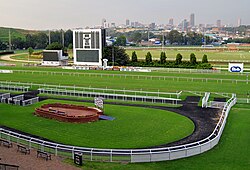
Kenilworth is a suburb of Johannesburg, South Africa. The suburb has Turffontein to the west and Rosettenville to the east, with the Turffontein Racecourse on its northern boundary. It is located in Region F of the City of Johannesburg Metropolitan Municipality.
La Rochelle is a suburb of Johannesburg, South Africa. South of the Johannesburg CBD, the suburbs of Turffontein and Rosettenville lie to its south. It is located in Region F of the City of Johannesburg Metropolitan Municipality.
Lindberg Park is a suburb of Johannesburg, South Africa. It is located in Region F of the City of Johannesburg Metropolitan Municipality.
Ophirton is a suburb of Johannesburg, South Africa. This industrial suburb lies three kilometers to south-west of the Johannesburg CBD. It is located in Region F of the City of Johannesburg Metropolitan Municipality.
Park Central is a suburb of Johannesburg, South Africa. It is located in Region F of the City of Johannesburg Metropolitan Municipality.
Selby is a suburb of Johannesburg, South Africa. It is located in Region F of the City of Johannesburg Metropolitan Municipality.
Southdale is a suburb of Johannesburg, South Africa. It is located in Region F of the City of Johannesburg Metropolitan Municipality.
Springfield is a suburb of Johannesburg, South Africa. It is a small industrial suburb located south of the Johannesburg CBD, close to La Rochelle. It is located in Region F of the City of Johannesburg Metropolitan Municipality.
Towerby is a suburb of Johannesburg, South Africa. This small suburb is tucked between Forest Hill and Rosettenville. It is located in Region F of the City of Johannesburg Metropolitan Municipality.
Turf Club is a suburb of Johannesburg, South Africa. It is a small suburb south of the Johannesburg CBD and located next to the suburb of Turffontein. It is located in Region F of the City of Johannesburg Metropolitan Municipality.
Glenesk is a suburb of Johannesburg, South Africa, and is located in Region F of the City of Johannesburg Metropolitan Municipality. The suburb lies just north of Turffontein and is south of the CBD.

Marshalltown is a suburb of Johannesburg, South Africa. It is located in Region F of the City of Johannesburg Metropolitan Municipality.
Salisbury Claims is a suburb of Johannesburg, South Africa. It is located in Region F of the City of Johannesburg Metropolitan Municipality.
Village Main is a suburb of Johannesburg, South Africa. The suburb lies less than a kilometre south of the Johannesburg CBD. Once mining land, now consists of light industry and one of the city's main freeway, M2 runs through the suburb. It is located in Region F of the City of Johannesburg Metropolitan Municipality.
Boysens is a suburb of Johannesburg, South Africa, located around 3.2 km southwest of city hall.
Parlshoop is a suburb of Johannesburg, South Africa, around 4 km west of City Hall. It borders Langlaagte to the north and Homestead Park to the northeast. The name comes from the village of Paarlshoop, the oldest private township on the Witwatersrand.
Village Deep is a suburb of Johannesburg, South Africa, around 1.3 km south of City Hall. It is an industrial suburb one kilometer from north to south and less than 300 meters from east to west. To the west is the Genesis Landfill Facility, to the south is the railway and Stafford, to the east is Eloff Street, to the southeast is Robinson Deep, to the northeast is Selby, and to the north is New Centre. Village Deep was founded on February 14, 1934 on Turffontein and Booysen Estate farms. The name, which was originally The Village, comes from the nearby Village Deep Levels gold mine.
Wemmer is a suburb of Johannesburg, South Africa, around 800 m south-southeast of City Hall.