
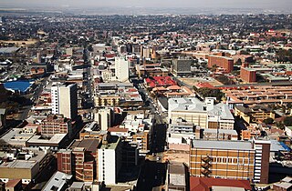
Johannesburg, colloquially known as Jozi, Joburg, or "The City of Gold", is the largest city in South Africa, classified as a megacity, and is one of the 100 largest urban areas in the world. According to Demographia, the Johannesburg–Pretoria urban area is the 26th-largest in the world in terms of population, with 14,167,000 inhabitants. It is the provincial capital and largest city of Gauteng, which is the wealthiest province in South Africa. Johannesburg is the seat of the Constitutional Court, the highest court in South Africa. Most of the major South African companies and banks have their head offices in Johannesburg. The city is located in the mineral-rich Witwatersrand range of hills and is the centre of large-scale gold and diamond trade.
Klerksdorp is located in the North West Province, South Africa. Klerksdorp, the largest city in the North West Province, is located 165 km (103 mi) southeast of Mahikeng, the provincial capital. Klerksdorp was also the first capital of the then Transvaal Republic and used to be the home of the first Stock Exchange in the region. It became an important trading town linking Kimberley to Johannesburg. It became home to a mix of farmers, miners and immigrants servicing the two industries.

Johannesburg is a large city in Gauteng Province of South Africa. It was established as a small village controlled by a Health Committee in 1886 with the discovery of an outcrop of a gold reef on the farm Langlaagte. The population of the city grew rapidly, becoming a municipality in 1898. In 1928 it became a city making Johannesburg the largest city in South Africa. In 2002 it joined ten other municipalities to form the City of Johannesburg Metropolitan Municipality. Today, it is a centre for learning and entertainment for all of South Africa. It is also the capital city of Gauteng.

Springs is a former independent city that is now part of the City of Ekurhuleni, based in the east of Johannesburg, in Gauteng Province, South Africa. It lies 50 km (31 mi) east of Johannesburg and 72 km (45 mi) southeast from Pretoria. Its name derives from the large number of springs in the area, and its estimated population is more than 121,610 in 2011. It is situated at 1628 m (5,340 ft) above sea level.

Alberton is a city situated on the southern part of the East Rand of the Gauteng Province in South Africa and is situated very close to the major urban centre of Johannesburg.
Germiston, also known as kwaDukathole, is a small city in the East Rand region of Gauteng, South Africa, administratively forming part of the City of Ekurhuleni Metropolitan Municipality since the latter's establishment in 2000. It functions as the municipal seat of Ekurhuleni, hosting the municipal council and administration.

Randfontein is a gold mining town in the West Rand, Gauteng, South Africa, 40 km (25 mi) west of Johannesburg. With the Witwatersrand gold rush in full swing, mining financier JB Robinson bought the farm Randfontein and, in 1889, floated the Randfontein Estates Gold Mining Company. The town was established in 1890 to serve the new mine and was administered by Krugersdorp until it became a municipality in 1929. Apart from having the largest stamp mill in the world, Randfontein, like many of the other outlying areas of Johannesburg, is essentially a rural collection of farms and small holdings in a particularly beautiful part of Gauteng.

Middelburg is a large farming and industrial town in the South African province of Mpumalanga.
Florida is a location in Gauteng province, South Africa. It is located about 16 kilometres west of Johannesburg. The area which is referred to as Florida was originally established as the farm Vogelstruisfontein. Today, it is a suburb of Roodepoort.

Melville is a bohemian suburb of Johannesburg, Gauteng, South Africa. It is the location of many restaurants and taverns, which are mostly frequented by students from the nearby University of Johannesburg, located in Auckland Park, and the University of the Witwatersrand, located in Braamfontein. It is one of the city's most popular tourist destinations. The suburb is to the west of the Johannesburg CBD. It is located in Region B of the City of Johannesburg Metropolitan Municipality.
Auckland Park is a suburb of Johannesburg, South Africa. It lies on a gentle slope, and is in close proximity to the suburbs of Melville, Brixton, Westdene and Richmond. Auckland Park is one of the few suburbs close to the Johannesburg city centre that has remained largely unaffected by the recent migration of Johannesburg residents to the city's northern suburbs. Auckland Park is home to a mix of nationalities and cultures, and the suburb is well known as the location of the South African Broadcasting Corporation headquarters.
Park Central is a suburb of Johannesburg, South Africa. It is located in Region F of the City of Johannesburg Metropolitan Municipality.
Selby is a suburb of Johannesburg, South Africa. It is located in Region F of the City of Johannesburg Metropolitan Municipality.
Craighall is a suburb of Johannesburg, South Africa and is bordered by Hyde Park, Dunkeld and Parkhurst. It sits in between the busy arterial routes of Jan Smuts Avenue and William Nicol highway and is located in Region B of the City of Johannesburg Metropolitan Municipality.
Doornfontein is an inner-city suburb of Johannesburg, South Africa, located to the east of the city centre, Region 8.
Village Main is a suburb of Johannesburg, South Africa. The suburb lies less than a kilometre south of the Johannesburg CBD. Once mining land, now consists of light industry and one of the city's main freeway, M2 runs through the suburb. It is located in Region F of the City of Johannesburg Metropolitan Municipality.
Greenside, is a suburb of Johannesburg, South Africa. Greenside borders on the suburbs Emmarentia, Parkview, Parkhurst and Victory Park.
The Imperial Military Hospital, Baragwanath, was a British military hospital built near Johannesburg, South Africa, during the Second World War. After the war it was purchased by the South African government and became one of the biggest hospitals in the world. Today it is called Chris Hani Baragwanath Hospital.

Westdene is a suburb of Johannesburg, South Africa. Westdene lies between the historic suburb of Sophiatown and Melville with the Melville Koppies West nature reserve to the north of the suburb. Westdene derives its name from its location, literally meaning west-valley. 'West' since it is located west from the city centre and with 'dene' derived from the Old English denu, meaning valley.
Parlshoop is a suburb of Johannesburg, South Africa, around 4 km west of City Hall. It borders Langlaagte to the north and Homestead Park to the northeast. The name comes from the village of Paarlshoop, the oldest private township on the Witwatersrand.

