Midrand is a former municipality in central Gauteng, South Africa. Situated in-between Centurion and Sandton, Midrand now forms part of the City of Johannesburg Metropolitan Municipality.

The East Rand is a major urban area located in the Gauteng province of South Africa. It is the urban eastern part of Witwatersrand that is functionally merged with the Johannesburg conurbation. The region extends from Alberton in the west to Springs in the east, and south down to Nigel. It includes the towns of Bedfordview, Benoni, Boksburg, Brakpan, Edenvale, Germiston, Kempton Park, Linksfield and Modderfontein. The East Rand is known as the transport hub of Johannesburg and includes Africa's largest and second busiest airport, OR Tambo International Airport.

The term Greater Johannesburg may mean:

The suburbs of Johannesburg are officially demarcated areas within the City of Johannesburg Metropolitan Municipality, South Africa. As in other Commonwealth countries, the term suburb refers to a "neighbourhood", although in South Africa most "suburbs" have legally recognised borders and often separate postal codes. The municipal functions for the area, such as municipal policing and social services, are still managed by the city government.

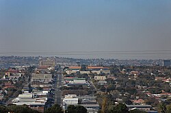
Kempton Park is a city in the East Rand region of Gauteng province, South Africa. It is part of the City of Ekurhuleni Metropolitan Municipality. It is situated south of Tembisa, one of the largest townships in South Africa, which is also part of Ekurhuleni. South Africa's busiest airport, O. R. Tambo International Airport is located in Kempton Park.

Bedfordview is an affluent suburb in western Ekurhuleni, sharing an administrative boundary with the City of Johannesburg Metropolitan Municipality, Gauteng, South Africa. Bedfordview has been part of the City of Ekurhuleni Metropolitan Municipality since 2000. The Eastgate Shopping Centre, one of the biggest in Africa when first built, is also located here.

The R21 is a major north–south provincial route in eastern Gauteng Province, South Africa. Built in the early 1970s, it remains one of two freeways linking Pretoria with Johannesburg, via the R24. As the eastern of the two freeways, it links the Pretoria city centre with OR Tambo International Airport, the N12 freeway, and Boksburg. Between the Solomon Mahlangu Drive on-ramp in Monument Park, Pretoria, and the N12 in Boksburg, the R21 is an 8 lane highway and motorway (freeway), with 4 lanes in each direction. It has off-ramps leading to Irene, Olifantsfontein, Benoni, and Kempton Park, including a partial offramp to Atlas Road. The route intersects the N1 highway near Centurion, the R24 near the airport, the N12 and N17 in Boksburg, and the N3 near Vosloorus on the East Rand, where it ends. The section from the N12 to the N3 is not a freeway. The R21 is also designated as the P157.

The R24 is a major East-West provincial route in the Gauteng and North West provinces that links OR Tambo International Airport with Rustenburg via Johannesburg, Krugersdorp and Magaliesburg. The process of renaming the streets and freeway that form the route from Krugersdorp eastward to OR Tambo International after anti-apartheid stalwart Albertina Sisulu was completed in 2013.

The R25 is a provincial route in South Africa that connects Johannesburg with Groblersdal via Kempton Park, Bapsfontein and Bronkhorstspruit.
Ivory Park is a densely populated residential suburb of Midrand in the Gauteng province of South Africa. It is located in Region A of the City of Johannesburg.

Thembisa, formerly Tembisa, is a large township situated to the north of Kempton Park on the East Rand, Gauteng, South Africa. It was established in 1957 when black people were resettled from Alexandra and other areas in Edenvale, Kempton Park, Midrand and Germiston.
The City of Ekurhuleni Metropolitan Municipality is a metropolitan municipality that forms the local government of the East Rand region of Gauteng, a large suburban region east of Johannesburg. Ekurhuleni means "place of peace" in XiTsonga. Ekurhuleni is one of the five districts of Gauteng and one of the eight metropolitan municipalities of South Africa. The seat of Ekurhuleni is Germiston and the most spoken language is Zulu at 28.6%. The city is home to South Africa's busiest airport, OR Tambo International Airport, which is in the Kempton Park area of Ekurhuleni.
Randpark Ridge is an upmarket suburb of Randburg, South Africa. It is located in the Randburg region of the City of Johannesburg. It fell into the town of Randburg during the apartheid era. Developed in the early 1980s and still relatively new, Randpark Ridge is bordered by several other suburbs including Weltevreden Park, Sundowner, Boskruin, Bromhof, Honeydew and Fairland. It is located on the north-west extremity of Johannesburg.
Greenstone Hill is a suburb on the East Rand of Gauteng Province in the City of Johannesburg Metropolitan Municipality in South Africa. It has only recently been developed although much of the surrounding areas such as Edenvale and Modderfontein have been developed and established for quite some time.
Bonaero Park is a southeastern suburb of Kempton Park, Ekurhuleni, in Gauteng province, South Africa. It lies directly next to OR Tambo International Airport, the busiest airport in Africa. Bonaero Park was built in the 1960s to house employees from the nearby military aircraft factory owned by Atlas Aircraft Corporation. In 1992 Atlas was absorbed into a new entity known as Denel, becoming part of Denel Aviation.
Modderfontein is a small town on the East Rand of Gauteng, South Africa. It began as a mining town adjacent to the Mud River, hence its name which is Afrikaans for "mud spring" or "fountain". It is located in the City of Johannesburg Metropolitan Municipality, adjacent to Kempton Park in the neighbouring City of Ekurhuleni Metropolitan Municipality.
The M37 is a metropolitan route in Greater Johannesburg, South Africa. It connects the N3 at Greenstone Shopping Mall with Katlehong via Edenvale and Germiston.
The M59 is a short metropolitan route in Greater Johannesburg, South Africa. The entire route is in the western part of the City of Ekurhuleni Metropolitan Municipality, particularly in Kempton Park and Edenvale.
The M78 is a short metropolitan route in Greater Johannesburg, South Africa. It is a short route connecting Illiondale with Klopper Park in the Edenvale/Germiston area of Ekurhuleni Metropolitan Municipality.
Olifantsfontein, also known as Clayville, is a small town on the East Rand in the Gauteng Province of South Africa. It is located at the north-western corner of the City of Ekurhuleni Metropolitan Municipality, just north of the Thembisa township. As of the 2011 Census, the town has a population of 14,526 people.