1994 Palm Sunday tornado outbreak

Last updated
1994 Palm Sunday tornado outbreak
1994 Palm Sunday tornado outbreak tracks.jpg
A map of that day's tornado tracks
TypeTornado outbreak
DurationMarch 27, 1994
Highest gust104 mph (167 km/h) at Randolph AFB, Texas
Tornadoes
confirmed
29
Max. rating1 F4 tornado
Duration of
tornado outbreak2
21 hours, 45 minutes
Largest hail4.5 in (11 cm)
Fatalities40 fatalities, 491 injuries
Damage$140 million (2005 USD)
Areas affected Southeastern United States

1Most severe tornado damage; see Fujita scale
2Time from first tornado to last tornado

The 1994 Palm Sunday tornado outbreak was the third notable US tornado outbreak to occur on Palm Sunday and the second to take place in the Southeastern United States. The outbreak produced 29 tornadoes from Texas to North Carolina, killing 40 people and injuring 491, and causing $140 million in damage. The deadliest storm of the outbreak, as well as in the US in 1994, was an F4 tornado that devastated Piedmont, Alabama. [1] It struck the Goshen United Methodist Church right in the middle of the Palm Sunday service, collapsing the roof on the congregation and killing 20 people inside, including the Rev. Kelly Clem's 4-year-old daughter Hannah. Two other houses of worship were also destroyed mid-service. The supercell that formed this tornado tracked for 200 miles (322 km) to South Carolina.

Contents

Meteorological synopsis

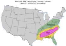
Day 1 outlook at 1930 UTC showing a high risk. March 27, 1994 "Palm Sunday" Severe Weather Outbreak map.png
Day 1 outlook at 1930 UTC showing a high risk.
Storm reports from the March 27, 1994 event. March2794stormreports.gif
Storm reports from the March 27, 1994 event.

The SPC started forecasting the outbreak on March 26, highlighting the risk of severe thunderstorms over the area that would eventually be impacted. They issued a "severe" forecast for most of the Southern, and some of the Mid-Atlantic states, forecasting "the potential for supercell storms, along with the possibility of tornadoes." [2]

By the morning of March 27, it was apparent that a very strong and potent airmass had set up over the Gulf states, with the SPC issuing a moderate risk for most of Alabama, the southern half of Mississippi, and most of Louisiana in their morning outlook. The 6 AM CST (1200 UTC) 500 MB analysis showed a strong southwest flow of near 80 knots over the Southern U.S., while at the 850 MB level, there existed winds of near 50 knots coming out of the state of Louisiana. [3] At the surface, temperatures in Alabama, Mississippi, and Georgia were in the low 70's Fahrenheit, with dewpoints were in the upper 60's to low 70's. [2] CAPE values at Centreville, Alabama were nearing 1,200 j/kg with no cap to speak of. A surface front left by rain during the previous evening was situated over northern parts of Alabama, Mississippi, and Georgia.

By 9 AM CST (1500 UTC), thunderstorms and severe weather were not only occurring along the boundary setup by the rain from the previous evening in the northern portions of Alabama and Mississippi, but further to the south as well. At 9:18 AM CST (1518 UTC), the SPC issued a tornado watch for Eastern Mississippi and Northern Alabama. The storms then rapidly intensified, with tornado warnings being issued by the Birmingham and Huntsville NWS offices before 11 AM local time. Both the deadly F4 tornado that struck the Goshen United Methodist Church in Cherokee County and the Marshall County F2 twister formed at about this time. [4] The SPC also issued a PDS Tornado Watch for all of Northern Georgia by 12 PM EST (1700 UTC), with the wording stating, "This is a particularly dangerous situation with the possibility of very damaging tornadoes. Also, large hail, dangerous lightning and damaging thunderstorm winds can be expected." Severe storms and tornadoes tracked into the northern Georgia region by 12:42 EST, and tornadoes continued to track across northern Georgia during the afternoon.

During the early-mid afternoon, analysis showed a very unstable airmass over the southern U.S., with CAPE values near 2,500 j/kg and SRH values of near 250 m2/s2 at Jackson, Mississippi. The 1800 UTC Centreville, Alabama sounding showed similar conditions, with CAPE over 2,500 j/kg and SRH values of over 500 m2/s2. This resulted in an EHI value of 8.49, which is strongly supportive of tornadic thunderstorms. Based on these soundings, the SPC issued a High Risk for their 1930 UTC outlook, noting a rapidly destabilized atmosphere and winds being much stronger than what was originally forecasted. [5] Noting the presence of a shortwave trough that was tracking into Mississippi and Louisiana as well as rapidly falling pressures in advance of a frontal boundary, the SPC issued a tornado watch for eastern Louisiana and central Mississippi, however, there were no reported tornadoes in this region on March 27. The SPC, seeing that storms were tracking into the Carolinas, issued a tornado watch for portions of the western and central Carolinas, as well as the portion of northeast Georgia not already included in the prior tornado watch. Tornadoes continued to track along this area from the mid-late afternoon, with an F3 tornado striking parts of northeast Georgia and the upstate of South Carolina, injuring 12, and another tornado along the border region of North Carolina and South Carolina injuring 13.

In Alabama, tornadoes continued in the central part of the state during the mid-late afternoon. An F1 tornado struck parts of Tuscaloosa County just after 4 PM. Funnel clouds were seen in Hueytown as a storm went over Jefferson County at around 4:30 PM local time. An F2 tornado was produced in Shelby County at 5:30 CST, damaging a high school and a residential neighborhood before destroying two mobile home parks.

During the cleanup from the F4 tornado that struck Cherokee County, emergency responders had to take cover as another funnel cloud was spotted just before 6 PM CST. The storms also produced hail up to 3 in (7.6 cm) in diameter and winds around 60 mph (97 km/h). The storm system also left behind extensive flooding in Winston and Walker Counties, with $150,000 worth of damage done to roads and bridges in Walker County. The final tornado of the outbreak was reported just before midnight in Greenville County in South Carolina. The National Weather Service offices in Birmingham, Atlanta, and Athens did not stop issuing warnings until late at night on the 27th or early in the morning on the 28th, issuing 75 tornado warnings and 182 severe weather products overall.

Overall, the outbreak of March 27, 1994 was not as synoptically evident as some of the past outbreaks that have occurred, as there was no deep surface low or trough present for forcing in the area where the storms occurred, and many of the ingredients necessary that were the cause of this outbreak were not able to be forecasted until the morning of the event. [6] [7]

Confirmed tornadoes

Confirmed tornadoes by Fujita rating
FUF0F1F2F3F4F5Total
0106472029

March 27 event

List of reported tornadoes – Sunday, March 27, 1994
F# LocationCountyTime (UTC)Path lengthDamage
Texas
F0NW of Mineral Wells [8] Palo Pinto 07050.1 miles (0.16 km)Brief touchdown reported by storm chasers with no damage. [8]
Alabama
F4SSW of Ragland to NE of Rock Run St. Clair, Calhoun, Cherokee 165550 miles (80 km)22 deaths — See section on this tornado
F2S of Guntersville [8] Marshall 17026 miles (9.7 km)A tornado damaged 103 homes just south of Guntersville and later passed near Lake Guntersville State Park. It also partially destroyed the roof of a nursing home. [1] 30 people were injured. [8]
F3 Rainsville/Sylvania to Henagar [8] DeKalb 173223 miles (37 km)This tornado was initially rated F4 in Storm Data but then downgraded in a reassessment. [1] [8] It destroyed 16 homes, 13 mobile homes, two businesses, and 12 poultry houses. 20 people were injured. [8]
F0SW of Nectar [8] Blount 17572.5 miles (4.0 km)Weak tornado damaged six homes, blew down electrical lines and trees, and destroyed three greenhouses. [8]
F1NE of Tuscaloosa Tuscaloosa 22022 miles (3.2 km)This tornado developed from reforming afternoon storms and hit unpopulated area near Lake Tuscaloosa, downing transmission towers. [8]
F2 Helena to Pelham/Indian Springs [8] Shelby 233112 miles (19 km)This tornado extensively damaged businesses and mobile homes and caused minor damage to a school in Pelham. It dissipated just west of Meadowbrook. [8] Rating disputed, ranked F3 by Grazulis. [9]
Georgia
F4SE of Rome to ESE of Jasper [10] Floyd, Bartow, Cherokee, Pickens 171450 miles (80 km)3 deaths — See section on this tornado
F0N of Lafayette [10] Walker 17551.5 miles (2.4 km)Weak tornado damaged some roofs and snapped trees along a discontinuous path. [10]
F0S of Lafayette Walker 17551 mile (1.6 km)Second tornado in the Lafayette area downed trees in uninhabited areas. [10]
F1 Lookout Mountain [10] Walker 18151 mile (1.6 km)Tornado "destroyed five single story mixed brick and wood homes" but only briefly touched down. [10]
F3NW of Dahlonega to NNE of Clarkesville [10] Dawson, Lumpkin, White, Habersham 181745 miles (72 km)3 deaths — A long-tracked tornado descended to the ground about 7 miles (11 km) north-northwest of Dawsonville at 2:17 p.m. EST. The tornado initially downed power lines and trees as it produced F0 damage in rural locations, but grew in size and intensity as it entered Lumpkin County. Widening to 0.25 miles (0.40 km) wide, the tornado caused widespread F2 damage to hilly terrain as it snapped 60-to-80-foot (18 to 24 m) tall pine trees. Upon reaching an area near Gordon Seabolt Road, about 2.5 miles (4.0 km) west-northwest of Dahlonega, an elderly man was killed by flying debris. [10] Soon the tornado passed just 1.5 miles (2.4 km) north of Dahlonega and later killed another elderly man in a mobile home 4 miles (6.4 km) northeast of Dahlonega. In this area, the tornado destroyed many "brick and wood" homes. [1] Thereafter, the tornado crossed the northwest slope of Yonah Mountain and then attained its peak intensity, F3 on the Fujita scale, as it broadened to 1.25 miles (2.01 km) wide and caused severe damage to homes about 7 miles (11 km) northeast of Cleveland. There, it "completely leveled" 10 homes and badly damaged 25–30 others. [10] The tornado then weakened to F2 strength and continued on to kill a person in a mobile home 6 miles (9.7 km) north of Clarkesville. It maintained intensity through rugged terrain until it lifted 6.5 miles (10.5 km) northeast of Clarkesville at 3:02 p.m. EST. [10] Along its path, the tornado caused over $17 million in property damage, killed three people and more than 500,000 chickens, and snapped "hundreds of thousands" of trees. [1] [10]
F0W of Rome Floyd 18303 miles (4.8 km)Tornado hit just north of Coosa and felled many trees along its brief path. [10]
F3S of Adairsville to NE of Jasper [10] Bartow, Gordon, Cherokee, Pickens 190140 miles (64 km)9 deaths — The second-deadliest tornado in the entire outbreak—and the deadliest of the outbreak in Georgia—touched down about 4.5 miles (7.2 km) south of Adairsville in Bartow County at 3:01 p.m. EST. Proceeding to the northeast, the tornado quickly strengthened to F2 intensity as it severely damaged five to seven homes and snapped trees in half. Tornado winds blew trees onto a truck, killing its occupant inside. [10] Next, the tornado increased to F3 strength and widened to .75 miles (1.21 km) as it passed through Pleasant Valley. There, the tornado threw a 4,000-pound (1.8 t) pickup truck for 300 yards (0.17 mi) and destroyed or heavily damaged 25–30 homes of brick or wood construction. [10] The tornado was reported to be so large and fast-moving that, like the 1925 Tri-State tornado, [11] [12] it was a "rotating fog bank" [1] indistinguishable from the cloud base as it passed through Pleasant Valley. Afterward, the tornado retained F3 strength as it passed 1.5 miles (2.4 km) north of Funkhouser and heavily damaged three to five homes of brick or wood construction. It went on to destroy or damage four homes near the intersections of Bartow, Gordon, and Pickens Counties. Entering Pickens County, the tornado grew to 1.5 miles (2.4 km) wide, snapping most trees at their base, and killed six people in a trailer that was thrown 100 to 250 yards (300 to 750 ft). [10] [13] It then killed two more people as it destroyed a single-story residence and a mobile home before lifting 3 miles (4.8 km) northeast of Jasper. It caused a total of $12,250,000 in damage and killed a total of nine people along its path. [10] At one point, according to engineer Timothy P. Marshall, the tornado moved at 60 miles per hour (97 km/h) and downed 1,000 trees each second. [1] A second, weaker, F2 tornado overlapped part of the path of this tornado and hit Pleasant Valley just 30 minutes after this F3 tornado left.
F3NW of Dahlonega to NE of Cleveland [10] Lumpkin, White 192322 miles (35 km)3 deaths — The second of two F3 tornadoes to hit near Dahlonega touched down 3.5 miles (5.6 km) northwest of that town at 3:23 p.m. EST. Only a minute later, it intensified to F2 intensity and instantly killed two people in a mobile home that disintegrated. [10] The tornado continued to intensify to F3 intensity as it caused a third and final death in a mobile home while snapping many large pines in rural areas north and northeast of Dahlonega. Then it fluctuated in intensity to F1 strength before passing 5 miles (8.0 km) north of Cleveland, causing significant damage to four businesses and ten homes. [10] Soon after, it re-intensified into an F3 tornado as it passed just .25 miles (0.40 km) south of the earlier F3 tornado while badly damaging 20 homes and destroying 15 in a rural subdivision. It then lifted after striking the subdivision and causing $3.5 million in total damages. Overall the tornado killed three people. [10]
F2ESE of Adairsville [10] Bartow 19352 miles (3.2 km)This tornado hit the same area that was damaged by the previous event and went through Pleasant Valley, but while only at F2 intensity. It destroyed or badly damaged five to seven homes in Pleasant Valley. [9] [10]
F0NW of Dawsonville [10] Dawson 19424 miles (6.4 km)Tornado uprooted several large trees. [10]
F3 Tallulah Falls to Walhalla, South Carolina [14] Habersham, Rabun, Oconee (SC) 200430 miles (48 km)This tornado badly damaged five buildings at Tallulah Falls before descending a 500-foot (152 m) cliff. [9] [10] It destroyed about 60 homes in Oconee County, South Carolina, with $5.5 million in damage there. [14] It was part of the Piedmont, Alabama, tornado family as items from that town, more than 140 mi (225 km) to the southwest, were found at Tallulah Falls. [10] The tornado was F2 at Tallulah Falls [10] and F3 in South Carolina. [9] [14]
F3NW of Cedartown to SE of Rome [10] Floyd 230120 miles (32 km) See section on this tornado
F1SE of Cave Spring to S of Rome [10] Floyd 230410 miles (16 km)Badly damaged roofs of frail wood homes and either uprooted or broke pine trees in half. [10]
F1WNW of Bremen [10] Haralson 00352 miles (3.2 km)Moderately damaged roofs and badly damaged a mobile home along with a chicken coop while uprooting or snapping trees. [10]
F0NW of Marietta [10] Cobb 01102 miles (3.2 km)Produced minimal roof damage to three homes and downed trees. Dissipated near Lake Allatoona in suburban Atlanta. [10]
South Carolina
F2NE of Inman to SE of Chesnee [14] to High Shoals, North Carolina, area [15] Spartanburg, Cherokee, Cleveland (NC), Gaston (NC) 205545 miles (72 km)This long-tracked tornado destroyed two mobile homes, badly damaged another home, and ripped apart three transmission towers—all indicative of F2 damage—before crossing into North Carolina. [14] Upon entering North Carolina, the tornado downed three high-voltage transmission towers about 15 miles (24 km) southwest of Shelby. Just 300 yd (900 ft) to the northeast of the transmission towers, the tornado destroyed a home along with a large barn house, plus three additional transmission towers, four mobile homes, two vehicles, and a cinder-block structure nearby. [15] Nearing Boiling Springs, the still-F2 tornado struck Gardner–Webb University and damaged several vehicles that were parked on campus. Just afterward, it hit downtown Boiling Springs, destroying an apartment duplex, a flower shop, and a car-wash station. [15] After leaving Boiling Springs, the tornado weakened to F1 intensity and leveled a greenhouse north of North Carolina Highway 150. It also blew down many trees before entering Shelby, damaging a church steeple and a billboard in town. [15] Thence it intensified somewhat and badly damaged homes, trees, and power lines before passing 3 miles (4.8 km) south of Cherryville. As it passed near Cherryville, the F1 tornado caused a porch roof to collapse east of North Carolina Highway 274. It also broke trees and blew a roof off a barn. [15] Farther along, the tornado also badly damaged three mobile homes. After crossing North Carolina Highway 279, the tornado finally dissipated as it approached the town of High Shoals in Gaston County. [15]
F1 Spartanburg to Blacksburg [14] Spartanburg, Cherokee 213035 miles (56 km)Tornado injured four people by falling trees and partially damaged roofs. Threw large tree branches onto homes and badly damaged a power substation. Numerous trees and power lines downed. [14]
F1S of Landrum to NW of Chesnee [14] Greenville, Spartanburg 214019 miles (31 km)Tornado caused minimal F1 damage to roofs, outbuildings, trees, and power lines. Formed from the same supercell that produced the Tallulah Falls–Walhalla tornado. [14]
F3NE of Clover [14] to Lake Wylie to Charlotte, North Carolina York, Gaston (NC), Mecklenburg (NC) 232718 miles (29 km)This tornado produced F1 damage in South Carolina, destroying a mobile home and an outbuilding; it also damaged many other mobile homes and outbuildings in Lake Wylie. [9] [14] After crossing into North Carolina, it destroyed a brick home and three mobile homes before striking the Catawba River. Next, the tornado struck Charlotte Douglas International Airport, where an Air National Guard building lost its roof. [9] Many vehicles and a DC-9 aircraft sustained damage as well. Two people were injured. The tornado then struck apartments and homes, several of which lost three-story walls and had roof damage. [9] Nearby, the tornado ripped steel poles at a restaurant from their concrete foundations, downed large trees, and caused significant damage to an elementary school before lifting just north of downtown Charlotte. At least two, and possibly nine, people were injured along the path. [9]
F0 Tigerville Greenville 04500.5 miles (0.80 km)Weak tornado displaced a garage roof, threw a boat, downed a large oak, and caused other negligible damage near the North Greenville University campus. [14]
North Carolina
F0NE of Liberty Alamance 00400.5 miles (0.80 km)Brief touchdown in sparsely populated area.
F0 Asheboro Randolph 01000.5 miles (0.80 km)Brief touchdown at the southeastern edge of Asheboro, with little damage.
Sources: Tornado History Project Data for March 27, 1994, SPC Storm Data

Ragland - Piedmont - Rock Run, Alabama

Ragland - Piedmont - Rock Run, Alabama
F4 tornado
1994piedmont.jpg
The Piedmont F4 tornado.
Max. rating1 F4 tornado
Fatalities22 fatalities, 150 injuries [16]
Damage$50.5 million (1994 USD)
1Most severe tornado damage; see Fujita scale

The first violent and the deadliest tornado of the outbreak developed 1 mile (1.6 km) south-southwest of Ragland in St. Clair County, Alabama, at 10:55 a.m. CST. With a 45-to-55-mile-per-hour (72 to 89 km/h) forward speed, the tornado first destroyed buildings east of Ragland before killing a woman on a campground west of Neely Henry Lake. Just prior to entering Calhoun County, the tornado destroyed 18 homes and 20 mobile homes. [8] Upon crossing the north side of Ohatchee the tornado threw a van into a ditch, killing a man inside and injuring three other occupants. After causing the death on U.S. Route 431, it passed through sparsely-populated, wooded land about 4 to 5 miles (6.4 to 8.0 km) west-northwest of Piedmont. As it passed north of Piedmont, the tornado struck the Goshen United Methodist Church in the former community of Goshen, killing 20 people in the church and injuring 92; [8] some sources say 90 were injured. [17] The tornado also destroyed two nearby churches, but killed no one in their congregations. [18] Parishioners in the Goshen United Methodist Church apparently received no warning [19] while attending services and some were crushed to death as the walls and roof collapsed upon them. [18] An inflow jet caused the south wall—which, being 18 feet (5.5 m) tall and 60 feet (18 m) wide, was built solely of masonry block—to collapse inward, so the timber-and-steel gable roof and other walls followed suit, crushing parishioners inside the sanctuary. [17] After striking the church, the tornado continued on and later dissipated 5 miles (8.0 km) northeast of Rock Run, near the Alabama–Georgia state line. Overall, the tornado killed 22 people. [8]

Rome–Canton–Jasper, Georgia

Rome–Canton–Jasper, Georgia
F4 tornado
Max. rating1 F4 tornado
Fatalities3 fatalities
Damage~$7 million (1994 USD)
1Most severe tornado damage; see Fujita scale

The second violent tornado of the outbreak developed in a rural area of Floyd County, Georgia, about 9 miles (14 km) southeast of Rome, at 1:14 p.m. EST. Upon touching down, the .125-mile (0.201 km) wide tornado uprooted large pines and oaks while causing F0 damage to five or six homes of "mixed brick and wood construction." [10] The tornado then moved northeast as it snapped trees before intensifying to F1 strength about 10 miles (16 km) west of Cartersville. During this, the tornado initially shrunk to .06 miles (0.097 km) wide, but then widened again to .125 miles (0.201 km) as it passed through Cassville, with F1 damage primarily to the roofs of 10–15 homes. The tornado blew down 20 large trees and damaged power lines in Cassville. [10]

Thereafter, the tornado increased greatly in size and intensity as it passed between White and Rydal, with the first and only F4 damage occurring in a rural area 15 miles (24 km) northwest of Canton. There, the 0.38-mile (0.61 km) wide tornado leveled "five two-story brick and wood homes" to the ground in the Indian Springs subdivision. [10] The tornado also severely damaged eight to 10 other homes and slightly damaged 12–15. Overall, the tornado was most destructive at Indian Springs and soon weakened as it continued northeast through wooded lands; however, its path briefly widened. [10] It killed two people in a trailer along Georgia State Route 140 in Bartow County and snapped 80-to-90-foot (24 to 27 m) tall pine trees nearby. Though the 1-mile (1.6 km) wide tornado impacted forested areas, it still caused major damage to 10 mobile homes and six permanent homes, as well as damage to four unspecified vehicles. [10]

Henceforth, the tornado continued to weaken to F2 intensity and contracted to .75 miles (1.21 km) wide as it passed into Pickens County, severely damaging 10–15 chicken coops along with 20–25 homes of brick and wood construction. [10] It killed one more person in a trailer before lifting from the ground about 6 miles (9.7 km) east-southeast of Jasper. Ultimately, it caused almost $7 million (1994 USD) in losses to properties and businesses in Bartow County alone, with another $1.5 million in losses in adjourning Pickens County. [10] The tornado killed three people and over 500,000 chickens along its track and leveled "thousands" of trees, with over $10 million in losses to agricultural interests. [10]

Cave Spring/Lindale, Georgia

Cave Spring/Lindale, Georgia
F3 tornado
Max. rating1 F3 tornado
FatalitiesNone
Damage$6.75 million (1994 USD)
1Most severe tornado damage; see Fujita scale

The sixth and final F3+ tornado to hit Georgia on March 27 touched down 8 miles (13 km) northwest of Cedartown at about 7:00 p.m. EST. Though mainly impacting rural areas at first, it badly damaged four wood homes and blew down many trees with resultant F1 damage. The tornado appeared reddish to eyewitnesses as it passed through rugged terrain. [10] As it crossed near SR 100, the tornado produced major roof damage to a few homes and destroyed a pair of chicken coops. Widening to 0.5 miles (0.80 km) wide, the tornado acquired a multiple vortex structure as residents observed two or three funnels rotating around the main vortex. [10] In southern Floyd County, about 2 miles (3.2 km) east of Cave Spring, the multiple-vortex tornado snapped trees in half and badly damaged five double-wide mobile homes along with three or four frail wood homes.

Afterward, the tornado strengthened to F2 intensity, causing more severe damage to wood homes, but soon contracted in size to .25 miles (0.40 km) wide and weakened into an F1 tornado. [10] However, as it neared to within 2.5 miles (4.0 km) southwest of Lindale, it widened yet again and rapidly strengthened into an F3 tornado as it passed through Leawood Estates. There, it reportedly leveled "fifteen mixed single and two story mixed brick and wood homes of poor construction," [10] along with some homes that were being built. The tornado caused 30 injuries, including one of a man who was thrown 1,000 yards (0.57 mi) into the street across from his home. Residents reported continuous lightning preceding and during the passage of the tornado and were alerted by their dogs barking. [10] Some residents also reported a smaller tornado south of the primary one.

After hitting Leawood Estates at maximum intensity, the tornado weakened back into an F2 tornado and shrunk to .25 miles (0.40 km) wide as it passed 6 miles (9.7 km) south of Rome. There, it badly damaged three poorly built wood homes, destroyed four mobile homes, and uprooted large trees. [10] Farther along, it decreased in size to just .125 miles (0.201 km) wide but caused significant damage to 15–20 homes of brick and wood construction. As it passed 7.2 miles (11.6 km) southeast of Rome, the tornado degenerated into an F0 tornado over wooded farmland while causing major roof damage to a few homes before dissipating. [10] According to the National Weather Service, the tornado destroyed 55–60 homes and did at least some damage to 140–150 others, with total losses reaching $6,750,000.

Effects on National Safety

The deaths at Goshen United Methodist Church brought to light the deficiencies in the NOAA Weather Radio network across the United States and the lack of NOAA Weather Radio use in many public spaces. Budget cuts in the 1970s had forced the National Weather Service to cut back on the expansion of new broadcast stations. Most urban and suburban areas in the country had sufficient coverage, but many rural areas had no coverage at all. After a visit to the Goshen site, then Vice President Al Gore pushed for further funding and expansion of the NOAA Weather Radio system, especially in rural areas. This was accomplished through an expansion of private-public partnerships, primarily by the National Weather Service leasing or using donated tower space from entities such as TV stations, public utilities, and state government agencies. Gore, also, pushed for facilities such as schools, hospitals, churches, and nursing homes to have weather radios on hand.

See also

Related Research Articles

<span class="mw-page-title-main">1965 Palm Sunday tornado outbreak</span> Natural disaster in the US

On April 10–12, 1965, a devastating severe weather event affected the Midwestern and Southeastern United States. The tornado outbreak produced 55 confirmed tornadoes in one day and 16 hours. The worst part of the outbreak occurred during the afternoon hours of April 11 into the overnight hours going into April 12. The second-largest tornado outbreak on record at the time, this deadly series of tornadoes, which became known as the 1965 Palm Sunday tornado outbreak, inflicted a swath of destruction from Cedar County, Iowa, to Cuyahoga County, Ohio, and a swath 450 miles long (724 km) from Kent County, Michigan, to Montgomery County, Indiana. The main part of the outbreak lasted 16 hours and 35 minutes and is among the most intense outbreaks, in terms of tornado strength, ever recorded, including at least four "double/twin funnel" tornadoes. In all, the outbreak killed 266 people, injured 3,662 others, and caused $1.217 billion in damage.

On April 5–6, 1936, an outbreak of 14 tornadoes struck the Southeastern United States, killing at least 454 people and injuring at least 2,500 others. Over 200 people died in Georgia alone, making it the deadliest disaster ever recorded in the state.

<span class="mw-page-title-main">1920 Palm Sunday tornado outbreak</span> 1920 windstorm in the Midwest and Southern United States

On March 28, 1920, a large outbreak of at least 37 tornadoes, 31 of which were significant, took place across the Midwestern and Southern United States. The tornadoes left at least 153 dead and at least 1,215 injured. Many communities and farmers alike were caught off-guard as the storms moved to the northeast at speeds that reached over 60 mph (97 km/h). Most of the fatalities occurred in Georgia (37), Ohio (28), and Indiana (21), while the other states had lesser totals. Little is known about many of the specific tornadoes that occurred, and the list below is only partial.

On February 19–20, 1884, one of the largest and most widespread tornado outbreaks in American history occurred over the Southeastern United States, known as the Enigma tornado outbreak due to the uncertain number of total tornadoes and fatalities. Nonetheless, an inspection of newspaper reports and governmental studies published in the aftermath reveals successive, long-tracked tornado families striking Alabama, Georgia, Illinois, Indiana, Kentucky, Mississippi, North Carolina, South Carolina, Tennessee and Virginia, with an estimation of at least 52—and possibly 60 or more—tornadoes.
<span class="mw-page-title-main">Tornadoes of 2008</span> List of notable tornadoes occurring in 2008

This page documents notable tornadoes and tornado outbreaks worldwide in 2008. Strong and destructive tornadoes form most frequently in the United States, Bangladesh, and Eastern India, but they can occur almost anywhere under the right conditions. Tornadoes also develop occasionally in southern Canada during the Northern Hemisphere's summer and somewhat regularly at other times of the year across Europe, Asia, and Australia. Tornadic events are often accompanied with other forms of severe weather, including strong thunderstorms, strong winds, and hail.

On March 21–22, 1952, a severe tornado outbreak generated eleven violent tornadoes across the Southern United States, which is the fourth-largest number of F4–F5 events produced by a single outbreak. Only the 1965 Palm Sunday tornado outbreak, the 1974 Super Outbreak, and the 2011 Super Outbreak surpassed this number. The outbreak caused 209 fatalities–50 of which occurred in a single tornado in Arkansas. The severe weather event also resulted in the fourth-largest number of tornado fatalities within a 24-hour period since 1950.

<span class="mw-page-title-main">Tornado outbreak of February 21–22, 1971</span> Catastrophic tornado outbreak in the Mississippi Delta

On February 21–22, 1971, a devastating tornado outbreak, colloquially known as the Mississippi Delta outbreak, struck portions of the Lower Mississippi and Ohio River valleys in the Southern and Midwestern United States. The outbreak generated strong tornadoes from Texas to Ohio and North Carolina. The two-day severe weather episode produced at least 19 tornadoes, and probably several more, mostly brief events in rural areas; killed 123 people across three states; and wrecked entire communities in the state of Mississippi. The strongest tornado of the outbreak was an F5 that developed in Louisiana and crossed into Mississippi, killing 47 people, while the deadliest was an F4 that tracked across Mississippi and entered Tennessee, causing 58 fatalities in the former state. The former tornado remains the only F5 on record in Louisiana, while the latter is the deadliest on record in Mississippi since 1950. A deadly F4 also affected other parts of Mississippi, causing 13 more deaths. Other deadly tornadoes included a pair of F3s—one each in Mississippi and North Carolina, respectively—that collectively killed five people.

The 1956 McDonald Chapel tornado was a deadly weather event that took place during the afternoon of April 15, 1956, across the Greater Birmingham area in Jefferson County, Alabama, with damage most severe in McDonald Chapel. The F4 tornado killed 25 people and injured 200 others. While only two known tornadoes touched down across the Southeastern United States on that day, the Birmingham tornado produced major devastation across areas west and north of downtown Birmingham.

On March 21–22, 1932, a deadly tornado outbreak struck the Midwestern and Southern United States. At least 38 tornadoes—including 27 deadly tornadoes and several long-lived tornado families—struck the Deep South, killing more than 330 people and injuring 2,141. Tornadoes affected areas from Mississippi north to Illinois and east to South Carolina, but Alabama was hardest hit, with 268 fatalities; the outbreak is considered to be the deadliest ever in Alabama, and among the worst ever in the United States, trailing only the Tri-State tornado outbreak in 1925, with 751 fatalities, and the Tupelo–Gainesville outbreak in 1936, with 454 fatalities. The 1932 outbreak is believed to have produced 10 violent tornadoes, eight of which occurred in Alabama alone.

<span class="mw-page-title-main">Tornado outbreak sequence of May 7–11, 2008</span>

A long-lived tornado outbreak sequence affected the Southern Plains, the southeastern and Middle Atlantic region of the United States from May 7–11, 2008. The storm produced 120 confirmed tornadoes starting on May 7 and lasting until late on May 11. The outbreak sequence killed 28 people across several states; 25 were killed by tornadoes. The event occurred less than a week after a deadly tornado outbreak that principally affected the state of Arkansas and killed 7 people.

A deadly tornado outbreak affected much of the central and Southern United States from April 29–May 1, 1909. Affecting particularly the Mississippi and Tennessee Valleys, it killed over 150 people, 60 of them in the U.S. state of Tennessee alone. The deadliest and longest-tracked tornado of the outbreak was a violent F4 tornado family that tracked across portions of western Tennessee on April 29, claiming at least 29 lives. Another deadly F4 tornado struck portions of northern Alabama and southern Tennessee early the next day, killing the same number. Other F4s in southern Missouri and southern Illinois on April 29 killed a combined 16 people. Deadly F3s in Georgia and Tennessee from April 30–May 1 killed a total of at least 53 people as well.

On April 29–30, 1924, an outbreak of at least 28 tornadoes—26 of which were significant, meaning F2 or stronger—affected the Southern United States. The tornadoes left 114 dead and at least 1,166 injured, mostly in the Carolinas, with 76 deaths in South Carolina alone, along with 16 in Georgia and 13 in Alabama. Killer tornadoes touched down from Oklahoma and Arkansas to Virginia. The deadliest tornado of the outbreak was a long-lived tornado family that produced F4 damage in rural portions of South Carolina, killing 53 people and injuring at least 534. The tornado is the deadliest ever recorded in South Carolina and is one of the longest-tracked observed in the state, having traveled 105 miles (169 km); some sources list a total path length of 135 mi (217 km), including the segment in Florence County, but this is now believed to have been a separate, F3 tornado.
<span class="mw-page-title-main">Tornadoes of 1989</span>

This page documents the tornadoes and tornado outbreaks of 1989, primarily in the United States. Most tornadoes form in the U.S., although some events may take place internationally. Tornado statistics for older years like this often appear significantly lower than modern years due to fewer reports or confirmed tornadoes.

On April 19–21, 1920, a multi-day severe weather event affected the Southeastern United States. The most intense portion of the outbreak occurred on the morning of April 20. At least seven tornadoes affected the American U.S. states of Mississippi, Alabama, and Tennessee, six of them rated violent F4s on the Fujita scale. The tornado outbreak killed at least 243 people.

On December 18–20, 1957, a significant tornado outbreak sequence affected the southern Midwest and the South of the contiguous United States. The outbreak sequence began on the afternoon of December 18, when a low-pressure area approached the southern portions of Missouri and Illinois. Supercells developed and proceeded eastward at horizontal speeds of 40 to 45 miles per hour, yielding what was considered the most severe tornado outbreak in Illinois on record so late in the calendar year. Total losses in the state were estimated to fall within the range of $8–$10 million.

The March 1875 Southeast tornado outbreak was a deadly tornado outbreak that affected portions of the Southern United States from March 19–20, 1875. At least 19 tornadoes were recorded, including seven that were destructive enough to be rated F4 by Thomas P. Grazulis. The worst damage and most of the deaths occurred in Georgia. Most of the damage appears to have been the result of two tornado families that moved along parallel paths 12 to 15 mi apart through parts of Georgia and South Carolina. These families each consisted of numerous long-tracked, intense tornadoes. The deadliest tornado of the outbreak was an estimated F4 that killed 28–42 people in and near Sparta, Georgia, and Edgefield, South Carolina, on March 20. A separate F4 that followed a similar trajectory may have killed as many as 30. In all, this outbreak killed at least 96 people, injured at least 377, and caused at least $650,000 in losses.
<span class="mw-page-title-main">Tornadoes of 1973</span>

This page documents notable tornadoes and tornado outbreaks worldwide in 1973, but mostly features events in the United States. According to tornado researcher Thomas P. Grazulis, documentation of tornadoes outside the United States was historically less exhaustive, owing to the lack of monitors in many nations and, in some cases, to internal political controls on public information. Most countries only recorded tornadoes that produced severe damage or loss of life. Consequently, available documentation in 1973 mainly covered the United States. On average, most recorded tornadoes, including the vast majority of significant—F2 or stronger—tornadoes, form in the U.S., although as many as 500 may take place internationally. Some locations, like Bangladesh, are as prone to violent tornadoes as the U.S., meaning F4 or greater events on the Fujita scale.

<span class="mw-page-title-main">Tornadoes of 1954</span>

This page documents the tornadoes and tornado outbreaks of 1954, primarily in the United States. Most tornadoes form in the U.S., although some events may take place internationally. Tornado statistics for older years like this often appear significantly lower than modern years due to fewer reports or confirmed tornadoes.

A widespread, destructive, and deadly tornado outbreak sequence affected the Southeastern United States from April 28 to May 2, 1953, producing 24 tornadoes, including five violent F4 tornadoes. The deadliest event of the sequence was an F4 tornado family that ravaged Robins Air Force Base in Warner Robins, Georgia, on April 30, killing at least 18 people and injuring 300 or more others. On May 1, a pair of F4 tornadoes also struck Alabama, causing a combined nine deaths and 15 injuries. Additionally, another violent tornado struck rural Tennessee after midnight on May 2, killing four people and injuring eight. Additionally, two intense tornadoes impacted Greater San Antonio, Texas, on April 28, killing three people and injuring 20 altogether. In all, 36 people were killed, 361 others were injured, and total damages reached $26.713 million (1953 USD). There were additional casualties from non-tornadic events as well, including a washout which caused a train derailment that injured 10.

<span class="mw-page-title-main">2019 Beauregard tornado</span> 2019 Tornado event in Alabama and Georgia, United States

On the afternoon of March 3, 2019, a violent and long-tracked EF4 tornado struck portions of eastern Alabama and western Georgia, causing extreme damage along its path. This tornado was the deadliest tornado in the United States since the 2013 Moore tornado, killing 23 and injuring 97. This tornado was part of a larger tornado outbreak that affected the Southeastern United States on this same day. This outbreak produced numerous tornadoes across Alabama and Georgia. This was the deadliest and strongest tornado of this outbreak, and the 8th deadliest in Alabama state history.

References

  1. 1 2 3 4 5 6 7 Grazulis 1997 , p. 1357
  2. 1 2 "Archived copy" (PDF). Archived from the original (PDF) on 2012-05-17. Retrieved 2016-05-30.{{cite web}}: CS1 maint: archived copy as title (link)
  3. "NOAA's National Weather Service - Birmingham, Alabama". Archived from the original on 2008-10-14.
  4. "NOAA's National Weather Service - Birmingham, Alabama". Archived from the original on 2008-07-25.
  5. "March 27, 1994 1930Z Outlook".
  6. "Hales/Vescio 18th SLS Conference Article".
  7. "Palm Sunday Tornado Outbreak - 27 March 1994". Archived from the original on 2017-05-11. Retrieved 2016-05-30.
  8. 1 2 3 4 5 6 7 8 9 10 11 12 13 14 15 "Storm Data and Unusual Weather Phenomena". Storm Data. Asheville, North Carolina: United States Department of Commerce. 36 (3): 12–16. March 1994.
  9. 1 2 3 4 5 6 7 8 Grazulis 1997 , p. 1361
  10. 1 2 3 4 5 6 7 8 9 10 11 12 13 14 15 16 17 18 19 20 21 22 23 24 25 26 27 28 29 30 31 32 33 34 35 36 37 38 39 40 41 42 43 44 45 46 47 48 49 50 "Late Reports". Storm Data. Asheville, North Carolina: United States Department of Commerce. 36 (7): 278–289. July 1994.
  11. Grazulis 2001 , p. 137
  12. Johns, Robert H.; Burgess, D. W.; Doswell III, C. A.; Gilmore, M. S.; Hart, J. A.; Piltz, S. F. (2013). "The 1925 Tri-State Tornado Damage Path and Associated Storm System". e-Journal of Severe Storms Meteorology. 8 (2).
  13. Grazulis 1997 , p. 1359
  14. 1 2 3 4 5 6 7 8 9 10 11 12 "Storm Data and Unusual Weather Phenomena". Storm Data. Asheville, North Carolina: United States Department of Commerce. 36 (3): 51–53. March 1994.
  15. 1 2 3 4 5 6 "Late Reports". Storm Data. Asheville, North Carolina: United States Department of Commerce. 36 (4): 213–215. April 1994.
  16. Alabama Event Report: F4 Tornado, NOAA
  17. 1 2 Grazulis 2001 , p. 160
  18. 1 2 Bragg, Rick (April 2, 1994). "Piedmont Journal: Tried by Deadly Tornado, an Anchor of Faith Holds". New York Times. pp. 2–12.
  19. Applebome, Peter (March 29, 1994). "Across the Tornado Belt, the Rubble Is Real but the Losses Are So Hard to Grasp". The New York Times. pp. A20.

Bibliography

Further information