Type | Tornado outbreak |
---|---|
Duration | April 10–12, 1979 |
Tornadoes confirmed | 61 confirmed |
Max. rating1 | F4 tornado |
Duration of tornado outbreak2 | 38 hours |
Fatalities | 58 fatalities, 1,927 injuries [1] |
Damage | unknown |
Areas affected | Midwestern and Southern United States |
Part of the tornado outbreaks of 1979 1Most severe tornado damage; see Fujita scale 2Time from first tornado to last tornado |
A destructive and deadly tornado outbreak impacted the Red River Valley on April 10, 1979. Several strong to violent tornadoes touched down throughout the region that day. One F4 tornado impacted Vernon, Texas. The most notable tornado was another F4 tornado that destroyed most of the southern part of Wichita Falls, Texas, and is commonly referred to as "Terrible Tuesday" by many meteorologists. Additional tornadoes were reported across the Southern Plains as well as in the Mississippi River Valley on April 11–12. Overall, the outbreak killed 58 people and injured 1,927 others. This tornado outbreak resulted from a storm system that was the same storm system [2] [3] that, just a few days later, produced the 1979 Easter flood, which was the worst disaster to befall Jackson, Mississippi in over a century, [4] causing over $500 million in 1979 dollars, forcing the evacuation of over 15,000 residents, and killing one. [3]
A deepening low pressure system formed in Colorado as a warm front lifted north pulling warm, moist, unstable air. There was strong upper level dynamics all coming together to produce strong tornado-producing supercells. In the early afternoon hours, three supercell thunderstorms formed. They moved northeastward, and as a trio spawned families of tornadoes. These supercells caused the most damaging tornadoes of the outbreak.
The first tornado formed near Crowell, Texas, at around 3:05 p.m. About 35 minutes later, the first killer one of the outbreak ripped through Vernon and killed 11 people. Then the supercell spawned one that killed three people in Lawton, Oklahoma. The second supercell spawned one that moved 74 miles (119 km).
The third supercell was the one that formed the Seymour and Wichita Falls tornadoes as part of a three-member tornado family. The first tornado formed near Seymour at around 4:53 pm. The storm spawned a second tornado that moved through the south and east sides of Wichita Falls at around 6:00 pm. The third member of the family formed near Waurika, Oklahoma, at around 8:00 p.m.
FU | F0 | F1 | F2 | F3 | F4 | F5 | Total |
---|---|---|---|---|---|---|---|
0 | 10 | 19 | 25 | 4 | 2 | 0 | 60 |
F# | Location | County / Parish | State | Start Coord. | Time (UTC) | Path length | Max width | Summary |
---|---|---|---|---|---|---|---|---|
F0 | S of Crosbyton | Crosby | TX | 33°39′N101°14′W / 33.65°N 101.23°W | 1908 | 2 miles (3.2 km) | [5] | |
F0 | E of Plainview | Hale | TX | 34°12′N101°41′W / 34.20°N 101.68°W | 1938 | 0.1 miles (160 m) | [5] | |
F2 | SW of Foard City to S of Rayland | Foard | TX | 33°51′N99°48′W / 33.85°N 99.80°W | 2105 | 22.1 miles (35.6 km) | Houses were unroofed, and barns were destroyed. [5] | |
F4 | SE of Rayland, TX to NE of Davidson, OK | Foard (TX), Wilbarger (TX), Tillman (OK) | TX, OK | 34°02′N99°28′W / 34.03°N 99.47°W | 2120 | 39.7 miles (63.9 km) | 11 deaths – A large wedge tornado struck the city of Vernon, destroying numerous houses and businesses including a cafe, a motel, and a truck stop. Seven of the deaths occurred when vehicles were thrown from U.S 287 in Texas. The tornado crossed into Oklahoma where it destroyed three houses and damaged five others. Overall, this violent tornado caused $27,000,000 in damage and injured 67 other people. [5] | |
F0 | SE of Thalia | Foard | TX | 33°59′N99°32′W / 33.98°N 99.53°W | 2120 | 2.5 miles (4.0 km) | [5] | |
F2 | Harrold, TX to Marlow, OK | Wilbarger (TX), Wichita (TX), Tillman (OK), Cotton (OK), Comanche (OK), Stephens (OK) | TX, OK | 34°05′N99°02′W / 34.08°N 99.03°W | 2155 | 74.1 miles (119.3 km) | 1 death – A large wedge tornado destroyed eight airplanes at an airport near Grandfield and took the exterior walls off a nearby house. A grain elevator was destroyed in the Hulen area, and houses were damaged in Pumpkin Center and near Walters. A woman died when she took shelter underneath a semi-truck, which rolled over her when the tornado struck. [5] | |
F2 | N of Hollister | Tillman | OK | 34°21′N98°54′W / 34.35°N 98.90°W | 2205 | 9.2 miles (14.8 km) | Three houses were destroyed, and several others were damaged. [5] | |
F1 | N of Faxon | Comanche | OK | 34°28′N98°37′W / 34.47°N 98.62°W | 2235 | 7.1 miles (11.4 km) | A mobile home was destroyed near Faxson, which resulted in two serious injuries, and two houses in the area were damaged. The tornado left suction vortex marks in open fields. [5] | |
F2 | NE of Seymour | Baylor | TX | 33°37′N99°18′W / 33.62°N 99.30°W | 2249 | 10.4 miles (16.7 km) | A strong tornado damaged roofs, telephone poles, and trees. It also uprooted shrubs and overturned a truck but remained over open country while at peak intensity. This tornado was well-documented on film by NSSL storm researchers. [5] | |
F3 | Southern Lawton | Comanche | OK | 34°34′N98°25′W / 34.57°N 98.42°W | 2305 | 4.5 miles (7.2 km) | 3 deaths – An intense tornado struck Lawton, destroying 116 structures and damaging at least 330 others. Unanchored houses were completely swept from their foundations. One person was killed when their car was tossed from a road. [5] | |
F1 | SW of Iowa Park | Wichita | TX | 33°54′N98°48′W / 33.90°N 98.80°W | 2308 | 0.1 miles (160 m) | [5] | |
F4 | SW of Wichita Falls, TX to E of Waurika, OK | Archer (TX), Wichita (TX), Clay (TX), Jefferson (OK) | TX, OK | 33°49′N98°39′W / 33.82°N 98.65°W | 2350 | 46.9 miles (75.5 km) | 42 deaths – See section on this tornado – 1,740 people were injured. This is the second-highest number of injuries caused by a single tornado in United States history after the Tri-State Tornado of 1925. [5] | |
F1 | Wichita Falls area | Wichita | TX | 33°54′N98°30′W / 33.90°N 98.50°W | 0000 | 2 miles (3.2 km) | Second, much weaker tornado in the area. [5] | |
F2 | S of Noble | Cleveland | OK | 35°06′N97°22′W / 35.10°N 97.37°W | 0040 | 2 miles (3.2 km) | Two barns were damaged. [5] | |
F2 | E of Bellemont | Pottawatomie, Lincoln | OK | 35°25′N96°45′W / 35.42°N 96.75°W | 0045 | 4.6 miles (7.4 km) | Two trailers were destroyed, and three houses were damaged. One person was injured. [5] | |
F2 | SW of Noble | Cleveland | OK | 35°06′N97°24′W / 35.10°N 97.40°W | 0050 | 1.5 miles (2.4 km) | A mobile home was destroyed. [5] | |
F1 | Hays area | Ellis | KS | 38°52′N99°19′W / 38.87°N 99.32°W | 0130 | 0.5 miles (0.80 km) | 67 yd (61 m) | [5] |
F3 | W of Pruitt City | Carter | OK | 34°21′N97°36′W / 34.35°N 97.60°W | 0155 | 12.8 miles (20.6 km) | Severe damage in the Pruitt City area. Forty-four houses and mobile homes were damaged or destroyed. Several vehicles, including a bus, were flipped and tossed. [5] | |
F0 | W of Oakland | Pottawatomie | OK | 34°07′N96°48′W / 34.12°N 96.80°W | 0205 | 0.2 miles (320 m) | [5] | |
F0 | N of Oakland | Pottawatomie | OK | 35°23′N96°58′W / 35.39°N 96.97°W | 0205 | 0.2 miles (320 m) | ||
F2 | SW of Novice | Runnels, Coleman | TX | 31°58′N99°48′W / 31.97°N 99.80°W | 0317 | 9.6 miles (15.4 km) | Large tornado destroyed several barns and scattered debris over a large area. [5] | |
F3 | SW of Talpa to N of Coleman | Runnels, Coleman | TX | 31°42′N99°45′W / 31.70°N 99.75°W | 0330 | 25 miles (40 km) | Houses and barns were ripped apart. [5] | |
F# | Location | County / Parish | State | Start Coord. | Time (UTC) | Path length | Max width | Summary |
---|---|---|---|---|---|---|---|---|
F1 | SE of Comanche | Comanche | TX | 31°52′N98°31′W / 31.87°N 98.52°W | 0550 | 0.1 miles (160 m) | [5] | |
F2 | S of Energy to W of Hico | Comanche, Hamilton | TX | 31°45′N98°22′W / 31.75°N 98.37°W | 0550 | 24 miles (39 km) | Barns were destroyed and homes sustained roof damage. A woman was injured when her truck rolled into the ditch in which she was taking cover. [5] | |
F1 | Mineral Wells area | Palo Pinto | TX | 32°48′N98°07′W / 32.80°N 98.12°W | 0556 | 0.1 miles (160 m) | [5] | |
F1 | NE of Allen | Pontotoc | OK | 34°54′N96°24′W / 34.90°N 96.40°W | 0601 | 3 miles (4.8 km) | 50 yards (46 m) | |
F2 | NW of Kingston | Marshall | OK | 34°02′N96°45′W / 34.03°N 96.75°W | 0705 | 0.1 miles (160 m) | A trailer and three barns were destroyed. | |
F1 | NE of Southmayd | Grayson | TX | 33°38′N96°42′W / 33.64°N 96.70°W | 0806 | 0.1 miles (160 m) | ||
F0 | W of Beland | Muskogee | OK | 35°42′N95°36′W / 35.70°N 95.60°W | 1000 | 0.1 miles (160 m) | ||
F2 | E of Hattieville | Conway | AR | 35°17′N92°48′W / 35.28°N 92.80°W | 1310 | 5.4 miles (8.7 km) | Six barns and two homes were destroyed. Other homes, barns, and outbuildings were damaged. | |
F1 | W of Mountain View | Stone | AR | 35°54′N92°04′W / 35.90°N 92.06°W | 1442 | 8.7 miles (14.0 km) | ||
F2 | Prairie Grove area | Washington | AR | 35°56′N94°17′W / 35.93°N 94.29°W | 1602 | 11.1 miles (17.9 km) | ||
F2 | N of Athens | Henderson, Van Zandt | TX | 32°10′N95°54′W / 32.16°N 95.90°W | 1610 | 13.3 miles (21.4 km) | ||
F2 | Sulphur Springs area | Hopkins | TX | 33°08′N95°37′W / 33.14°N 95.61°W | 1612 | 8.3 miles (13.4 km) | ||
F1 | NW of Hainesville | Wood | TX | 32°43′N95°22′W / 32.72°N 95.37°W | 1702 | 0.1 miles (160 m) | ||
F2 | SW of Eagletown, OK to W of Big Fork, AR | McCurtain (OK), Sevier (AR), Polk (AR) | OK, AR | 33°59′N94°35′W / 33.99°N 94.59°W | 1715 | 42 miles (68 km) | Three people were injured in a mobile home near the beginning of the path. Major damage in the Grannis area. Six homes, 19 trailers, and an elementary school were destroyed, where four students were injured. Two homes were also destroyed near Wickes. Tornado injured a total of 20 people and caused $1,750,000 in damage. | |
F0 | W of Hurley | Stone | MO | 36°55′N93°27′W / 36.92°N 93.45°W | 1730 | 0.1 miles (160 m) | ||
F2 | NE of Bodcaw | Nevada | AR | 33°35′N93°22′W / 33.58°N 93.37°W | 2010 | 0.5 miles (0.80 km) | Three homes were destroyed and others were damaged. | |
F2 | SW of Guy | Faulkner | AR | 35°19′N92°21′W / 35.31°N 92.35°W | 2015 | 3 miles (4.8 km) | Several buildings were torn apart and a cemetery was damaged. Caused $190,000 in damage. | |
F1 | SW of Homer | Claiborne | LA | 32°44′N93°08′W / 32.74°N 93.13°W | 2100 | 2 miles (3.2 km) | ||
F3 | SE of Sargent to E of Licking | Douglas, Texas | MO | 37°03′N92°04′W / 37.05°N 92.07°W | 2100 | 35.4 miles (57.0 km) | ||
F2 | E of East End to NE of Lonoke | Saline, Pulaski, Lonoke | AR | 34°44′N92°19′W / 34.74°N 92.32°W | 2100 | 30.81 miles (49.58 km) | Several trailers were destroyed. Damage also occurred to machinery, homes, and outbuildings. | |
F0 | SW of Bakersfield | Ozark | MO | 36°31′N92°11′W / 36.51°N 92.18°W | 2115 | 2.7 miles (4.3 km) | ||
F1 | NE of Fryatt | Fulton | AR | 36°28′N91°38′W / 36.47°N 91.64°W | 2145 | 0.5 miles (0.80 km) | ||
F1 | W of Beebe | White | AR | 35°04′N91°57′W / 35.06°N 91.95°W | 2150 | 6.5 miles (10.5 km) | ||
F2 | NE of Crossett to NE of Hamburg | Ashley | AR | 33°09′N91°55′W / 33.15°N 91.92°W | 2210 | 10.4 miles (16.7 km) | Tornado caused $3,500,000 to the downtown business district in Hamburg. Second tornado to strike Hamburg in three days. | |
F2 | NW of Black Rock | Lawrence | AR | 36°06′N91°06′W / 36.10°N 91.10°W | 2235 | 2 miles (3.2 km) | Caused over $300,000 in damage to homes, barns, and a rock crushing plant. | |
F1 | N of Topeka | Shawnee | KS | 39°07′N95°44′W / 39.11°N 95.74°W | 2300 | 4.1 miles (6.6 km) | ||
F2 | E of McGehee | Desha | AR | 33°37′N91°23′W / 33.62°N 91.38°W | 2315 | 3.6 miles (5.8 km) | Homes and businesses were torn apart in the McGehee area. Caused a total of $449,000 in damage. | |
F1 | NW of Phillipsburg | Phillips | KS | 39°49′N99°25′W / 39.82°N 99.41°W | 2315 | 0.1 miles (160 m) | 33 yards (30 m) | No significant damage was reported. [6] |
F1 | NE of Libertyville | St. Francois, Ste. Genevieve | MO | 37°43′N90°16′W / 37.71°N 90.27°W | 2330 | 8.5 miles (13.7 km) | A concrete block building was destroyed, and another was partially destroyed. A home was badly damaged, losing a large portion of its front side. Two barns were also destroyed and scattered across a field. | |
F1 | E of Long Island | Phillips | KS | 39°57′N99°28′W / 39.95°N 99.46°W | 0000 | 4 miles (6,400 m) | 200 yards (180 m) | A farm building and fences were damaged. [6] |
F0 | S of Sweetwater | Buffalo | NE | 41°01′N98°59′W / 41.01°N 98.99°W | 0000 | 0.5 miles (0.80 km) | ||
F1 | NW of Roundaway | Coahoma | MS | 33°59′N90°38′W / 33.99°N 90.64°W | 0005 | 0.5 miles (0.80 km) | ||
F2 | Liberty to SE of Barnesville | Clay, Clinton | MO | 39°14′N94°25′W / 39.24°N 94.41°W | 0100 | 20.1 miles (32.3 km) | Several homes and businesses, a mobile home park, a church, and a school were damaged. Three barns were destroyed as well. Five bus passengers were injured when they took shelter in a ditch, only to have the bus roll onto them. | |
F2 | S of Dycusburg to W of Bellville | Crittenden, Webster, Henderson | KY | 37°08′N88°11′W / 37.14°N 88.18°W | 0150 | 36 miles (58 km) | Tornado tore a large section of roof from an elementary school near Robards. Five people were injured when trailers were overturned. | |
F2 | E of Evansville to N of Boonville | Vanderburgh, Warrick | IN | 37°59′N87°30′W / 37.98°N 87.50°W | 0200 | 16.98 miles (27.33 km) | 1 death – Moved from the east side of Evansville to north of Boonville. A shopping center and a lumber yard were damaged. One person was killed and two others were injured when the tornado struck a mobile home park. | |
F# | Location | County / Parish | State | Start Coord. | Time (UTC) | Path length | Max width | Summary |
---|---|---|---|---|---|---|---|---|
F0 | Dickson area | Dickson | TN | 36°04′N87°22′W / 36.07°N 87.37°W | 0500 | 0.3 miles (480 m) | 33 yards (30 m) | |
F1 | Florence area | Lauderdale | AL | 34°48′N87°40′W / 34.80°N 87.67°W | 0530 | 0.5 miles (0.80 km) | 20 yards (18 m) | One more more brief tornadoes occurred within a larger area of straight-line wind damage in Lauderdale County. Three people were injured. |
F2 | NE of Columbus | Lowndes | MS | 33°32′N88°24′W / 33.53°N 88.40°W | 0900 | 7.7 miles (12.4 km) | 880 yards (800 m) | [7] |
F4 tornado | |
---|---|
Max. rating1 | F4 tornado |
Fatalities | 42 fatalities, 1,740 injuries |
Damage | $400 million (1979 USD) |
1Most severe tornado damage; see Fujita scale |
The Wichita Falls tornado formed in Archer County and moved northeast and damaged a few rural homes and high voltage towers at F1-F2 intensity. It rapidly intensified to F4 intensity as it entered the city near Memorial Stadium by McNiel Jr. High School on Southwest Parkway, which was located to the west of Wichita Falls at approximately 6:07 p.m., damaging both structures severely. Hail the size of golf balls preceded the touchdown and continued for approximately 15 minutes. It then became calm before the winds began to pick up.
Continuing at F4 intensity, the now massive wedge tornado, which was at its maximum 1.5 miles (2.4 km) wide, cut a 2.5-mile (4.0 km) swath of destruction through the south side of town. It first destroyed an apartment complex, where the first fatalities took place, as it moved along Southwest Parkway. Continuing east-northeastward, the violent tornado destroyed a large portion of a residential neighborhood before heavily damaging a commercial building along Southwest Parkway. The Southwest National Bank Building was completely obliterated, leaving nothing behind except for its vault. As it moved north of Southwest Parkway, the tornado destroyed many homes in both the Western Hills Addition and the Faith Village Addition and severely damaged Ben Milam Elementary School. The tornado then crossed over Kemp Boulevard and destroyed several commercial businesses, including a restaurant, resulting in several additional fatalities. Despite passing north of the Sikes Senter Shopping Mall, intense winds from the outer circulation of the tornado heavily damaged a few stores and blew many cars in the mall's parking lot some distance away from where they originated and stacked on top of each other. Still at F4 intensity as it moved east-northeastward, the tornado moved over a greenbelt area, passing just barely south of Midwestern State University as it severely damaged several more housing additions. (Colonial Park, Hursh, Southmoor, Southwinds, and Southern Hills) A number of people tried to flee as the tornado moved along US 281 and 287 by driving east on Southwest Parkway. The tornado blew many of those vehicles off those roadways, inflicting numerous fatalities. 25 of the 42 fatalities from the tornado were vehicle related, 16 of which were of people who left their homes to evade the massive tornado. Only 5 of the homes that were left actually incurred damage.
The tornado then weakened slightly, but remained at F3 intensity, destroying the Sun Valley housing area, the Sunnyside Heights Mobile Home Park, and several large commercial businesses, including the Levi Strauss Plant, before exiting the east side of town. It then moved into Clay County and changed its appearance to display a multiple-vortex structure. There were at times five separate vortices visible within the tornado. It inflicted additional F0-F2 damage south of Dean and Byers, but no more fatalities occurred. Crossing into Oklahoma, the tornado inflicted additional damage near Waurika before dissipating.
The injury count for this tornado was 1,740, the most injuries ever recorded for an F4/EF4 tornado. It is believed that many more minor injuries were never recorded. [8] [9] [10]
State | Total | County | County total |
---|---|---|---|
Indiana | 1 | Warrick | 1 |
Oklahoma | 3 | Comanche | 3 |
Texas | 54 | Wichita | 42 |
Wilbarger | 12 | ||
Totals | 58 | ||
All deaths were tornado-related, | |||
At the end of the outbreak, 54 people lost their lives in Texas, three were killed in Oklahoma and one was killed in Indiana. The Wichita Falls tornado alone killed 42 people and caused $400 million in damage ($2.17 billion in today's dollars). [11] The tornado cut a path 8 miles (13 km) through the city, with significant devastation.
The 1974 Super Outbreak was the second-largest tornado outbreak on record for a single 24-hour period, just behind the 2011 Super Outbreak. It was also the most violent tornado outbreak ever recorded, with 30 F4/F5 tornadoes confirmed. From April 3–4, 1974, there were 148 tornadoes confirmed in 13 U.S. states and the Canadian province of Ontario. In the United States, tornadoes struck Illinois, Indiana, Michigan, Ohio, Kentucky, Tennessee, Alabama, Mississippi, Georgia, North Carolina, Virginia, West Virginia, and New York. The outbreak caused roughly $843 million USD in damage, with more than $600 million occurring in the United States. The outbreak extensively damaged approximately 900 sq mi (2,331 km2) along a total combined path length of 2,600 mi (4,184 km). At one point, as many as 15 separate tornadoes were occurring simultaneously.
The 1999 Oklahoma tornado outbreak was a significant tornado outbreak that affected much of the Central and parts of the Eastern United States, with the highest record-breaking wind speeds of 301 ± 20 mph (484 ± 32 km/h). During this week-long event, 154 tornadoes touched down. More than half of them were on May 3 and 4 when activity reached its peak over Oklahoma, Kansas, Nebraska, Texas, and Arkansas.
From April 26 to 27, 1991, multiple supercells across Oklahoma and Kansas led to a regional tornado outbreak. Forced by a potent trough and focused along a dryline, these distinct thunderstorms moved northeast through a moist and highly unstable environment. A total of 55 tornadoes were confirmed, many of which were strong, F2 or greater on the Fujita scale. A widely documented F5 tornado tore through Andover, Kansas, killing 17 people. Additional fatalities occurred from significant tornadoes in other portions of Kansas and Oklahoma, with 21 deaths recorded in total. An F4 tornado was detected by a mobile doppler weather radar team which observed winds up to 270 mph (430 km/h) at the top of the funnel, the first time winds of F5 intensity were measured by radar, and the highest winds recorded by radar at the time. A news team filming an F2 tornado sought shelter under a Kansas Turnpike overpass, causing a misconception that overpasses can provide adequate shelter during a tornado. This outbreak occurred within a transition period for the National Weather Service and proved the value of NEXRAD radars, which were utilized in Oklahoma to provide advanced warning to residents.
Memorial Stadium is an American football and soccer stadium in Wichita Falls, Texas located on Southwest Parkway at Barnett Road. It is owned and operated by the Wichita Falls Independent School District.
This page documents the tornadoes and tornado outbreaks of 2002, primarily in the United States. Most tornadoes form in the U.S., although some events may take place internationally. The year had several large outbreaks that included the Veterans Day Weekend tornado outbreak and the Midwest to Mid-Atlantic United States tornado outbreak.
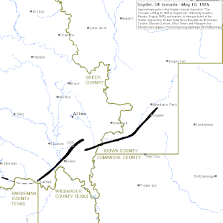
The 1905 Snyder, Oklahoma, tornado was a powerful tornado that struck the town of Snyder, Oklahoma, in Kiowa County on Wednesday, May 10, 1905. The event was one of the worst natural disasters ever to hit the state of Oklahoma. The cyclone killed 97 people, making it the second most deadly tornado in Oklahoma history. The tornado was part of a larger, multiple-day tornado outbreak that hit several states across the Midwestern United States, including Kansas, Oklahoma, and Missouri.
Tornadoes are more common in the United States than in any other country or state. The United States receives more than 1,200 tornadoes annually—four times the amount seen in Europe. Violent tornadoes—those rated EF4 or EF5 on the Enhanced Fujita Scale—occur more often in the United States than in any other country.
The March 1990 Central United States tornado outbreak affected portions of the United States Great Plains and Midwest regions from Iowa to Texas from March 11 to March 13, 1990. The outbreak produced at least 64 tornadoes across the region, including four violent tornadoes; two tornadoes, which touched down north and west of Wichita, Kansas, were both rated F5, including the tornado that struck Hesston. In Nebraska, several strong tornadoes touched down across the southern and central portion of the state, including an F4 tornado that traveled for 131 miles (211 km) making it the longest tracked tornado in the outbreak. Two people were killed in the outbreak, one each by the two F5 tornadoes in Kansas.
This page documents the tornadoes and tornado outbreaks of 1990, primarily in the United States. Most tornadoes form in the U.S., although some events may take place internationally. Tornado statistics for older years like this often appear significantly lower than modern years due to fewer reports or confirmed tornadoes, however by the 1990s tornado statistics were coming closer to the numbers we see today.
The tornado outbreak of April 22–25, 2010 was a multi-day tornado outbreak across a large portion of the Southern United States, originally starting in the High Plains on April 22, 2010, and continuing through the Southern Plains on April 23, and the Mississippi and Tennessee Valleys on April 24. The most severe activity was on April 24, particularly in Mississippi. The outbreak was responsible for ten tornado-related fatalities on April 24, all in Mississippi from a single supercell that crossed the entire state.
The 1999 Bridge Creek–Moore tornado was a large and exceptionally powerful F5 tornado in which the highest wind speeds ever measured globally were recorded at 301 ± 20 miles per hour (484 ± 32 km/h) by a Doppler on Wheels (DOW) radar. Considered the strongest tornado ever recorded to have affected the metropolitan area, the tornado while near peak intensity devastated southern portions of Oklahoma City, Oklahoma, United States, along with surrounding suburbs and towns to the south and southwest of the city during the early evening of Monday, May 3, 1999. Parts of Bridge Creek were rendered unrecognizable. The tornado covered 38 miles (61 km) during its 85-minute existence, destroying thousands of homes, killing 36 people, and leaving US$1 billion in damage, ranking it as the fifth-costliest on record not accounting for inflation. Its severity prompted the first-ever use of the tornado emergency statement by the National Weather Service.
From April 14–16, 2011, a tornado outbreak, among the largest recorded tornado outbreaks in U.S. history, produced 178 confirmed tornadoes across 16 states, resulting in severe destruction on all three days of the outbreak. A total of 38 people were killed from tornadoes and an additional five people were killed as a result of straight-line winds associated with the storm system. The outbreak of severe weather and tornadoes led to 43 deaths in the Southern United States. This was the largest number of fatalities in an outbreak in the United States since the 2008 Super Tuesday tornado outbreak. It is locally referred to as the "Forgotten Outbreak" in Alabama as it was vastly overshadowed by the 2011 Super Outbreak less than two weeks later.
The 2011 Super Outbreak was the largest, costliest, and one of the deadliest tornado outbreaks ever recorded, taking place in the Southern, Midwestern, and Northeastern United States from April 25 to 28, 2011, leaving catastrophic destruction in its wake. Over 175 tornadoes struck Alabama, Mississippi, and Tennessee, which were the most severely damaged states. Other destructive tornadoes occurred in Arkansas, Georgia, Kentucky, Louisiana, New York, and Virginia, with storms also affecting other states in the Southern and Eastern United States. In total, 360 tornadoes were confirmed by NOAA's National Weather Service (NWS) and Government of Canada's Environment Canada in 21 states from Texas to New York to southern Canada. Widespread and destructive tornadoes occurred on each day of the outbreak. April 27 was the most active day, with a record 216 tornadoes touching down that day from midnight to midnight CDT. Four of the tornadoes were rated EF5, which is the highest ranking on the Enhanced Fujita scale; typically these tornadoes are recorded no more than once a year.
The Tornado outbreak sequence of March 18–24, 2012 was a long lasting tornado outbreak that occurred due to a slow moving, but powerful trough and cutoff low. The outbreak began in the Great Plains, where, over a two-day period, several tornadoes touched down, some of which were significant. The North Platte area was damaged by an EF3 that was produced by a supercell that spawned many tornadoes throughout its lifespan. The tornadic activity then shifted the Southern United States over subsequent days, particularly in Louisiana and Mississippi. These states were struck by a series of tornadoes for 3 days, most of which were relatively weak on the Enhanced Fujita Scale. However, a few reached EF2 intensity and caused considerable damage. Tornado activity continued across the Ohio Valley on the 23rd, with one confirmed fatality in southern Illinois.
From April 13 to 16, 2012, a major tornado outbreak occurred across a large portion of the Great Plains. The storms resulted in six tornado-related fatalities, all of which occurred as a result of a nighttime EF3 tornado that caused major damage in and around Woodward, Oklahoma. Numerous other tornadoes occurred, including a violent EF4 tornado that passed near Marquette, Kansas, and an EF3 that caused major damage in Wichita.
This page documents the tornadoes and tornado outbreaks of 1976, primarily in the United States. Most tornadoes form in the U.S., although some events may take place internationally. Tornado statistics for older years like this often appear significantly lower than modern years due to fewer reports or confirmed tornadoes.
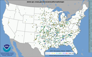
This page documents notable tornadoes and tornado outbreaks worldwide in 1973, but mostly features events in the United States. According to tornado researcher Thomas P. Grazulis, documentation of tornadoes outside the United States was historically less exhaustive, owing to the lack of monitors in many nations and, in some cases, to internal political controls on public information. Most countries only recorded tornadoes that produced severe damage or loss of life. Consequently, available documentation in 1973 mainly covered the United States. On average, most recorded tornadoes, including the vast majority of significant—F2 or stronger—tornadoes, form in the U.S., although as many as 500 may take place internationally. Some locations, like Bangladesh, are as prone to violent tornadoes as the U.S., meaning F4 or greater events on the Fujita scale.
This page documents the tornadoes and tornado outbreaks of 1964, primarily in the United States. Most tornadoes form in the U.S., although some events may take place internationally. Tornado statistics for older years like this often appear significantly lower than modern years due to fewer reports or confirmed tornadoes.
This page documents the tornadoes and tornado outbreaks of 1949, primarily in the United States. Most recorded tornadoes form in the U.S., although some events may take place internationally. Tornado statistics for older years like this often appear significantly lower than modern years due to fewer reports or confirmed tornadoes.
This page documents the tornadoes and tornado outbreaks of 1947, primarily in the United States. Most recorded tornadoes form in the U.S., although some events may take place internationally. Tornado statistics for older years like this often appear significantly lower than modern years due to fewer reports or confirmed tornadoes.
This article includes a list of general references, but it lacks sufficient corresponding inline citations .(January 2014) |