Henderson County, Kentucky

Last updated

Henderson County
Henderson county kentucky courthouse (3146526178).jpg
Henderson County courthouse in Henderson, Kentucky
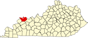
Map of Kentucky highlighting Henderson County.svg
Location within the U.S. state of Kentucky
Kentucky in United States.svg
Kentucky's location within the U.S.
Coordinates: 37°48′N87°34′W / 37.8°N 87.57°W / 37.8; -87.57
CountryFlag of the United States.svg United States
StateFlag of Kentucky.svg  Kentucky
Founded1798
Named for Richard Henderson
Seat Henderson
Largest cityHenderson
Area
  Total466 sq mi (1,210 km2)
  Land437 sq mi (1,130 km2)
  Water30 sq mi (80 km2)  6.4%
Population
 (2020)
  Total44,793
  Estimate 
(2023)
44,119 Decrease2.svg
  Density96/sq mi (37/km2)
Time zone UTC−6 (Central)
  Summer (DST) UTC−5 (CDT)
Congressional district 1st
Website hendersonky.us

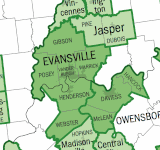
Henderson County is a county in the U.S. state of Kentucky. The county is located in western Kentucky on the Ohio River across from Evansville, Indiana. As of the 2020 census, the population was 44,793. [1] Its county seat is Henderson. [2]

Contents

The county was formed in 1798 [3] and named for Richard Henderson [4] who purchased 17,000,000 acres (69,000 km2) of land from the Cherokee, part of which would later make up the county.

Henderson County lies within the West Kentucky Coal Field area. It is also part of the Evansville, IN-KY Metropolitan Statistical Area.

History

The Transylvania Co., also known as Richard Henderson & Co., in 1775 purchased from the Cherokees a large swath of wilderness between the Kentucky River and Cumberland River, encompassing approximately half of what would become Kentucky as well as a portion of northern Tennessee. Their intention was to establish a 14th colony to be called Transylvania Colony. To help attract people to purchase land and populate the region, Henderson & Co. hired pioneer, explorer, woodsman, and frontiersman Daniel Boone to lead settlers through Cumberland Gap and direct woodsmen to cut the Wilderness Road through the Kentucky forest. However, the Continental Congress declined to act on Transylvania Co.'s petition without the consent of Virginia and North Carolina, which laid claim to the disputed lands.

In December 1778, Virginia's Assembly declared the Transylvania claim void. In compensation, Henderson and his partners received a grant of 200,000 acres on the Ohio River below the mouth of Green River. In 1797, the surviving Transylvania Company investors and heirs sent Samuel Hopkins and Thomas Allin to the Henderson Grant land to lay out a town and mark off land for the respective investors. The location they selected for the town was the site of an existing settlement that sat high above the Ohio River called Red Banks. The new town was subsequently named Henderson. [5]

Henderson County was created out of Christian County in December 1798, and was officially established in May 1799. Henderson was designed as its county seat. The county initially encompassed a larger area than it does today. It was reduced in size when Hopkins County was formed in 1806, when Union County was established in 1811, and when Webster County was established in 1860. [6]

In August 1799, serial killers Micajah and Wiley Harpe came to the house of Moses Stegall, near what is now Dixon in Webster County, and murdered his wife, child, and a visitor. Moses Stegall later tracked down the brothers, and killed Micajah Harpe, cutting off his head and hanging it in a tree as a warning to other outlaws. Wiley Harpe was captured and hanged four years later in Mississippi.

During the 19th century, a cultivar of dark tobacco raised in Henderson County became very popular in Great Britain and continental Europe. Henderson became the largest dark-tobacco market in the world, generating considerable wealth in Henderson County. Around 1880, Henderson had 17 stemmeries in the city and 18 in the county. Stemmeries were where tobacco was stripped from its stem and made ready for use. [7] However, tobacco production in Henderson County declined through the 20th century and early 21st century, with few farmers still raising the labor-intensive crop. [8]

A peninsula across the Ohio from Henderson, which now forms Union Township, Vanderburgh County, Indiana, was the subject of Handly's Lessee v. Anthony , a U.S. Supreme Court case in 1820. [9] An area known as "Green River Island" is part of Kentucky, even though it is on the Indiana side of the Ohio River. The Ellis Park Race Course is located there.

A workplace shooting occurred at an Atlantis Plastics factory in Henderson, Kentucky, United States on June 25, 2008. The gunman, 25-year-old Wesley Neal Higdon, shot and killed five people and critically injured a sixth, before taking his own life. [10] The mass murder is the worst in the history of Henderson County, surpassing the triple homicides that took place in 1799 and 1955. [11]

Geography

According to the United States Census Bureau, the county has a total area of 466 square miles (1,210 km2), of which 437 square miles (1,130 km2) is land and 30 square miles (78 km2) (6.4%) is water. [12] The county's northern border with Indiana is mostly formed by the Ohio River, though some of the county lies north of the river.

Adjacent counties

Demographics

Historical population
CensusPop.Note
1800 1,468
1810 4,703220.4%
1820 5,71421.5%
1830 6,65916.5%
1840 9,54843.4%
1850 12,17127.5%
1860 14,26217.2%
1870 18,45729.4%
1880 24,51532.8%
1890 29,53620.5%
1900 32,90711.4%
1910 29,352−10.8%
1920 27,609−5.9%
1930 26,295−4.8%
1940 27,0202.8%
1950 30,71513.7%
1960 33,5199.1%
1970 36,0317.5%
1980 40,84913.4%
1990 43,0445.4%
2000 44,8294.1%
2010 46,2503.2%
2020 44,793−3.2%
2023 (est.)44,119 [13] −1.5%
U.S. Decennial Census [14]
1790–1960 [15] 1900–1990 [16]
1990–2000 [17] 2010–2020 [1]

As of the census [18] of 2000, there were 44,829 people, 18,095 households, and 12,576 families residing in the county. The population density was 102 per square mile (39/km2). There were 19,466 housing units at an average density of 44 per square mile (17/km2). The racial makeup of the county was 91.16% White, 7.10% Black or African American, 0.16% Native American, 0.33% Asian, 0.01% Pacific Islander, 0.39% from other races, and 0.86% from two or more races. Hispanic or Latino people of any race were 0.97% of the population.

There were 18,095 households, out of which 32.40% had children under the age of 18 living with them, 54.40% were married couples living together, 11.60% had a female householder with no husband present, and 30.50% were non-families. 26.40% of all households were made up of individuals, and 10.60% had someone living alone who was 65 years of age or older. The average household size was 2.43 and the average family size was 2.93.

In the county, the population was spread out, with 24.60% under the age of 18, 8.40% from 18 to 24, 30.00% from 25 to 44, 23.90% from 45 to 64, and 13.10% who were 65 years of age or older. The median age was 37 years. For every 100 females, there were 93.60 males. For every 100 females age 18 and over, there were 90.60 males.

The median income for a household in the county was $35,892, and the median income for a family was $44,703. Males had a median income of $33,838 versus $22,572 for females. The per capita income for the county was $18,470. About 9.70% of families and 12.30% of the population were below the poverty line, including 17.20% of those under age 18 and 10.10% of those age 65 or over.

Communities

Cities

Census-designated places

Other unincorporated places

Ghost town

Notable people

Politics

United States presidential election results for Henderson County, Kentucky [20]
Year Republican Democratic Third party
No.%No.%No.%
2020 12,73061.51%7,63936.91%3281.58%
2016 12,15961.69%6,70734.03%8444.28%
2012 10,29655.29%8,09143.45%2351.26%
2008 9,52347.95%10,04950.60%2891.46%
2004 10,46755.97%8,10143.32%1330.71%
2000 7,69848.00%8,05450.22%2871.79%
1996 5,09234.39%8,05154.38%1,66311.23%
1992 5,12531.78%8,27051.28%2,73116.94%
1988 6,91147.27%7,64852.31%610.42%
1984 7,38951.88%6,79547.71%580.41%
1980 5,07437.15%8,08259.17%5033.68%
1976 4,05333.45%7,91665.32%1491.23%
1972 6,23160.68%3,88937.87%1491.45%
1968 3,51232.74%5,06247.19%2,15220.06%
1964 2,73425.35%8,02274.38%290.27%
1960 5,30248.79%5,56551.21%00.00%
1956 5,08546.92%5,50150.76%2522.33%
1952 4,92945.25%5,91354.28%510.47%
1948 1,90424.13%5,49969.70%4866.16%
1944 2,68331.22%5,88768.49%250.29%
1940 2,45526.65%6,72773.03%290.31%
1936 1,81120.50%6,83577.38%1872.12%
1932 2,48527.98%6,10068.69%2963.33%
1928 5,44357.03%4,06842.62%330.35%
1924 4,90253.67%4,04644.30%1862.04%
1920 4,16135.51%7,27262.06%2852.43%
1916 2,21836.41%3,69960.73%1742.86%
1912 1,15721.51%3,09857.58%1,12520.91%

See also

Related Research Articles

<span class="mw-page-title-main">Brown County, Ohio</span> County in Ohio, United States

Brown County is a county in the U.S. state of Ohio. As of the 2020 United States Census, the population was 43,676. The county seat and largest city is Georgetown. The county was created in 1818 and is named for Major General Jacob Brown, an officer in the War of 1812 who was wounded at the Battle of Lundy's Lane. Brown County is part of the Cincinnati-Middletown, OH-KY-IN Metropolitan Statistical Area.

<span class="mw-page-title-main">Webster County, Kentucky</span> County in Kentucky, United States

Webster County is a county located in the U.S. state of Kentucky. As of the 2020 census, the population was 13,017. Its county seat is Dixon and its largest city is Providence. It is the southernmost county in the Evansville, IN–KY Metropolitan Statistical Area. The county was formed in 1860 from parts of Henderson, Hopkins, and Union Counties and named for American statesman Daniel Webster (1782–1852). It was mainly pro-Confederate during the American Civil War and was the site of several skirmishes and some guerrilla warfare. Since 2018 it has been a moist county, with Providence and Sebree voting to allow alcohol sales, and Clay doing so in 2022.

<span class="mw-page-title-main">Union County, Kentucky</span> County in Kentucky, United States

Union County is a county in the U.S. state of Kentucky. As of the 2020 census, the population was 13,668. Its county seat is Morganfield. The county was created effective January 15, 1811.

<span class="mw-page-title-main">Meade County, Kentucky</span> County in Kentucky, United States

Meade County is a county located in the U.S. state of Kentucky. As of the 2020 census, the population was 30,003. Its county seat is Brandenburg. The county was founded December 17, 1823, and named for Captain James M. Meade, who was killed in action at the Battle of River Raisin during the War of 1812. Meade County is part of the Elizabethtown-Fort Knox, KY Metropolitan Statistical Area, which is included in the Louisville/Jefferson County-Elizabethtown-Madison, KY-IN Combined Statistical Area.

<span class="mw-page-title-main">McLean County, Kentucky</span> County in Kentucky, United States

McLean County is a county located in the U.S. state of Kentucky. As of the 2020 census, the population was 9,152. Its county seat is Calhoun and its largest city is Livermore. McLean is a prohibition or dry county. McLean County is part of the Owensboro, KY Metropolitan Statistical Area, which has a population of some 114,752.

<span class="mw-page-title-main">Logan County, Kentucky</span> County in Kentucky, United States

Logan County is a county in the southwest Pennyroyal Plateau area of the U.S. Commonwealth of Kentucky. As of the 2020 census, the population was 27,432. Its county seat is Russellville.

<span class="mw-page-title-main">Hopkins County, Kentucky</span> County in Kentucky, United States

Hopkins County is a county located in the western part of the U.S. state of Kentucky. As of the 2020 census, the population was 45,423. Its county seat is Madisonville. Hopkins County was created December 9, 1806 from Henderson County. It was named for General Samuel Hopkins, an officer in both the American Revolutionary War and War of 1812, and later a Kentucky legislator and U.S. Congressman.

<span class="mw-page-title-main">Green County, Kentucky</span> County in Kentucky, United States

Green County is a county located in the U.S. state of Kentucky. Its county seat and only municipality is Greensburg. Green was a prohibition or dry county until 2015.

<span class="mw-page-title-main">Daviess County, Kentucky</span> County in Kentucky, United States

Daviess County ( "Davis"), is a county in Kentucky. As of the 2020 census, the population was 103,312. Its county seat is Owensboro. The county was formed from part of Ohio County on January 14, 1815.

<span class="mw-page-title-main">Bracken County, Kentucky</span> County in Kentucky, United States

Bracken County is a county located in the U.S. state of Kentucky. As of the 2020 census, the population was 8,400. Its county seat is Brooksville. The county was formed in 1796. Bracken County is included in the Cincinnati-Middletown, OH-KY-IN Metropolitan Statistical Area.

<span class="mw-page-title-main">Hanover, Indiana</span> Town in Indiana, United States

Hanover is a town in Hanover Township, Jefferson County, southeast Indiana, along the Ohio River. The population was 3,546 at the 2010 census. Hanover is the home of Hanover College, a small Presbyterian liberal arts college. The tallest waterfall in Indiana, Fremont Falls, is located in Hanover.

<span class="mw-page-title-main">Grandview, Indiana</span> Town in Indiana, United States

Grandview is a town in Hammond Township, Spencer County, Indiana, along the Ohio River. The population was 749 at the 2010 census.

<span class="mw-page-title-main">Rockport, Indiana</span> City in Indiana, United States

Rockport is a city in Ohio Township and the county seat of Spencer County, Indiana, along the Ohio River. The population was 2,270 at the 2010 census. Once the largest community in Spencer County, the city has recently been surpassed by the town of Santa Claus. At 37°53'1" north, Rockport is also the southernmost city in the state, located slightly south of Evansville, Cannelton, or Mount Vernon.
<span class="mw-page-title-main">Carrollton, Kentucky</span> City in Kentucky, United States

Carrollton is a home rule-class city in—and the county seat of—Carroll County, Kentucky, United States, at the confluence of the Ohio and Kentucky rivers. The population was 3,938 at the 2010 census.

<span class="mw-page-title-main">Henderson, Kentucky</span> City in Kentucky, United States

Henderson is a home rule-class city along the Ohio River and the county seat of Henderson County, Kentucky, United States. The population was 29,781 at the 2020 U.S. census. It is part of the Evansville–Henderson, IN–KY Metropolitan Area, locally known as the "Tri-State Area," and is considered the southernmost suburb of Evansville, Indiana.

<span class="mw-page-title-main">Robards, Kentucky</span> City in Kentucky, United States

Robards is a home rule-class city in Henderson County, Kentucky, United States. The population was 515 at the 2010 census, down from 564 at the 2000 census.

<span class="mw-page-title-main">Brandenburg, Kentucky</span> City in Kentucky, United States

Brandenburg is a home rule-class city on the Ohio River in Meade County, Kentucky, in the United States. The city is 40 miles (64 km) southwest of Louisville. It is the seat of its county. The population was 2,894 at the 2020 census.

<span class="mw-page-title-main">Dixon, Kentucky</span> City in Kentucky, United States

Dixon is a home rule-class city in and the county seat of Webster County, Kentucky, United States. The population was 933 at the 2020 census. Dixon is located at the junction of US 41A and KY 132. It was established with a courthouse and post office in 1860 when the county was formed.

<span class="mw-page-title-main">Higginsport, Ohio</span> Village in Ohio, United States

Higginsport is a village in Lewis Township, Brown County, Ohio, United States, along the Ohio River. The population was 213 at the 2020 census.

<span class="mw-page-title-main">Shawnee, Hamilton County, Ohio</span> Census-designated place in Ohio, United States

Shawnee is a census-designated place (CDP) in Miami Township, Hamilton County, Ohio, United States, 21 miles (34 km) west of downtown Cincinnati. The population of Shawnee was 747 at the 2020 census.

References

  1. 1 2 "State & County QuickFacts". United States Census Bureau. Retrieved July 6, 2022.
  2. "Find a County". National Association of Counties. Archived from the original on May 31, 2011. Retrieved June 7, 2011.
  3. "Henderson County". The Kentucky Encyclopedia. 2000. Archived from the original on September 4, 2015. Retrieved August 22, 2014.
  4. The Register of the Kentucky State Historical Society, Volume 1. Kentucky State Historical Society. 1903. pp.  35.
  5. Kleber, John E. (1992). The Kentucky Encyclopedia. The University Press of Kentucky. p. 423. ISBN   0-8131-1772-0 . Retrieved April 29, 2020.
  6. Hogan, Roseann Reinemuth (1992). Kentucky Ancestry: A Guide to Genealogical and Historical Research. Ancestry Publishing. p. 250. ISBN   9780916489496 . Retrieved July 26, 2013.
  7. Dixon, Abby (November 11, 2020). "Henderson's Tobacco History". Henderson Tourist Commission. Retrieved April 29, 2020.
  8. White, Doug (October 2, 2017). "Growing tobacco: Henderson family one of few left doing it here". The Gleaner. Henderson, Kentucky. Retrieved April 29, 2020.
  9. Handly's Lessee v. Anthony, 18 U.S. 374 (1820)
  10. Lenz, Ryan (June 25, 2008). "6 dead in Henderson, Ky., plastics plant shooting". Associated Press. Archived from the original on June 28, 2008.
  11. Smith, Beth (June 26, 2008). "Rampage at Atlantis Plastics ends with six dead". Henderson Gleaner .
  12. "2010 Census Gazetteer Files". United States Census Bureau. August 22, 2012. Archived from the original on August 12, 2014. Retrieved August 16, 2014.
  13. "Annual Estimates of the Resident Population for Counties: April 1, 2020 to July 1, 2023". United States Census Bureau. Retrieved March 14, 2024.
  14. "U.S. Decennial Census". United States Census Bureau. Retrieved August 16, 2014.
  15. "Historical Census Browser". University of Virginia Library. Retrieved August 16, 2014.
  16. "Population of Counties by Decennial Census: 1900 to 1990". United States Census Bureau. Retrieved August 16, 2014.
  17. "Census 2000 PHC-T-4. Ranking Tables for Counties: 1990 and 2000" (PDF). United States Census Bureau. Archived (PDF) from the original on March 27, 2010. Retrieved August 16, 2014.
  18. "U.S. Census website". United States Census Bureau . Retrieved January 31, 2008.
  19. "LaVerne Butler". Lexington Herald Leader, December 18, 2010. Retrieved December 23, 2010.
  20. Leip, David. "Dave Leip's Atlas of U.S. Presidential Elections". uselectionatlas.org. Retrieved April 9, 2018.

37°48′N87°34′W / 37.80°N 87.57°W / 37.80; -87.57