The Louisville metropolitan area is the 43rd largest metropolitan statistical area (MSA) in the United States. It had a population of 1,395,855 in 2020 according to the latest official census, and its principal city is Louisville, Kentucky.

The Danville Micropolitan Statistical Area is a Micropolitan Statistical Area (μSA) in Virginia as defined by the United States Office of Management and Budget (OMB). As of the 2010 census, the μSA had a population of 106,561

The Toledo Metropolitan Area, or Greater Toledo, or Northwest Ohio is a metropolitan area centered on the American city of Toledo, Ohio. As of the 2020 census, the four-county Metropolitan Statistical Area (MSA) had a population of 646,604. It is the sixth-largest metropolitan area in the state of Ohio, behind Cincinnati–Northern Kentucky, Cleveland, Columbus, Dayton, and Akron.
The Charleston Metropolitan Statistical Area, as defined by the United States Census Bureau, is an area consisting of three counties in West Virginia, anchored by the city of Charleston. It is the largest metropolitan area entirely within the state of West Virginia. While the Huntington Metro Area is more populous, it spans three states, and the core county of the Charleston area, Kanawha County, is more populous than the West Virginia portion of the Huntington area.

The Lansing–East Lansing Metropolitan Statistical Area is a metropolitan area located in Central Michigan defined by the Office of Management and Budget, and encompassing the counties of Eaton, Clinton, Ingham and Shiawassee. The region is colloquially referred to as "Mid" or Central Michigan, and less often as "Greater Lansing" or the "Capital Area". As of the 2020 census, the MSA had a population of 541,297. It ranks as Michigan's third-largest metropolitan area behind metropolitan Detroit and Grand Rapids.
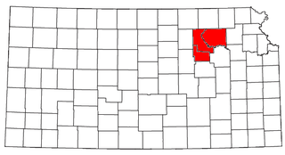
The Manhattan–Junction City Combined Statistical Area, as defined by the United States Census Bureau, is an area consisting of three counties in northeastern Kansas, anchored by the city of Manhattan. It was upgraded from a Micropolitan Statistical Area (μSA) to a Metropolitan Statistical Area (MSA) by the Office of Management and Budget on November 20, 2008. It was changed from a Metropolitan Statistical Area (MSA) to a Combined Statistical Area (CSA) by the Office of Management and Budget on February 28, 2013.

The New Bern Metropolitan Statistical Area, as defined by the United States Census Bureau, is an area consisting of three counties in the Inner Banks region of eastern North Carolina, anchored by the city of New Bern. The designation of the area was changed from Micropolitan to Metropolitan in 2013.

The Paducah, KY–IL Metropolitan Statistical Area, as defined by the United States Census Bureau, is an area consisting of five counties – three in the Jackson Purchase region of Kentucky, a fourth Kentucky county bordering the Purchase, and one in Southern Illinois – anchored by the city of Paducah, Kentucky. The Paducah KY-IL Micropolitan Statistical Area was upgraded to Metropolitan Statistical Area (MSA) status on July 21, 2023, by the Office of Management and Budget.. Carlisle County, Kentucky, was added to the area following the 2020 Census of the Population. The total MSA population from the 2020 United States Census was 103,486.
The Frankfort Micropolitan Statistical Area, as defined by the United States Census Bureau, is an area consisting of two counties in central Kentucky, anchored by the city of Frankfort. As of the 2000 census, the Micropolitan Statistical Area (μSA) had a population of 66,798.
The Mount Sterling Micropolitan Statistical Area, as defined by the United States Census Bureau, is an area consisting of three counties in Kentucky, anchored by the city of Mount Sterling. As of the 2000 census, the μSA had a population of 40,195.

The Glasgow Micropolitan Statistical Area, as defined by the United States Census Bureau, is an area consisting of two counties in Kentucky, anchored by the city of Glasgow. As of the 2000 census, the μSA had a population of 48,070.
The Fort Madison–Keokuk, IA-IL-MO Micropolitan Statistical Area, as defined by the United States Census Bureau, locally known as the "Tri-State" area, was an area consisting of three counties – one in southeast Iowa, one in northeast Missouri, and one in west central Illinois, anchored by the cities of Fort Madison, Iowa and Keokuk, Iowa. As of the 2010 census, the μSA had a population of 62,105. An estimate by the Census Bureau, as of July 1, 2012, placed the population at 61,477, a decrease of 1.01%. When the 2023 definitions were released this area was dissolved with Lee County, Iowa being included as part of the Burlington–Fort Madison, IA–IL Combined Statistical Area.

The Canton–Massillon Metropolitan Statistical Area, as defined by the United States Census Bureau, is an area consisting of two counties in Northeast Ohio, anchored by the cities of Canton and Massillon. As of the 2020 census, the MSA had a population of 401,574. The MSA is also part of the Cleveland–Akron–Canton, OH Combined Statistical Area, which had a population of 3,633,962 in 2020, making it the largest CSA in Ohio.

The Mankato — North Mankato Metropolitan Statistical Area, as defined by the United States Census Bureau, is an area consisting of two counties in south central Minnesota, anchored by the cities of Mankato and North Mankato. It was upgraded from a Micropolitan Statistical Area (μSA) to a Metropolitan Statistical Area (MSA) by the Office of Management and Budget on November 20, 2008. As of the 2020 census, the μSA had a population of 103,566.

The Staunton–Waynesboro Metropolitan Statistical Area is a United States Metropolitan Statistical Area (MSA) in Virginia, as defined by the Office of Management and Budget (OMB). As of the 2020 census, the MSA had a population of 125,433.
The Jasper micropolitan statistical area, as defined by the United States Census Bureau, is an area consisting of one county in southwestern Indiana, anchored by the city of Jasper. At the 2020 census, the Micropolitan area (μSA) had a population of 43,637 up from a population of 41,889 in the 2010 census. In previous statistical definition updates, the area also included Pike County which was removed in the 2023 updates.

The Madison, Wisconsin, metropolitan area, also known as Greater Madison, is the metropolitan area surrounding the city of Madison, Wisconsin. Madison is the state capital of Wisconsin and is Wisconsin's second largest city, and the metropolitan area is also the state's second largest which the Madison MSA borders to its east.

The Lafayette-West Lafayette, Indiana Metropolitan Statistical Area, as defined by the United States Census Bureau, is an area consisting of three counties in Indiana, anchored by the cities of Lafayette and West Lafayette. As of the July 1, 2021, the MSA had an estimated population of 224,709. Metro area population in 2021 is 237,130 and was 235,066 in 2020, a growth of 16% over 2010. In 2010, the Lafayette, Indiana, metro area population was 210,297.

The Corbin Micropolitan Statistical Area, as defined by the United States Census Bureau, is an area consisting of Whitley County, Kentucky, anchored by the Whitley County portion of the city of Corbin. As of the 2000 census, the μSA had a population of 35,865.

The Corbin, Kentucky Micropolitan Area Micropolitan Area is made up of four counties in the Eastern Coalfield region of Kentucky. Before 2013, the area was officially known as the Corbin-London, KY Combined Statistical Area, and consisted of the Corbin Micropolitan Statistical Area and the London Micropolitan Statistical Area. The Corbin micropolitan area consisted of Whitley County, and the London micropolitan area consisted of Laurel County.