Knox County, Kentucky

Last updated

Knox County
County
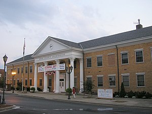
Knox County Kentucky Courthouse.jpg
Knox County courthouse in Barbourville
Map of Kentucky highlighting Knox County.svg
Location within the U.S. state of Kentucky
Kentucky in United States.svg
Kentucky's location within the U.S.
Coordinates: 36°53′26″N83°51′15″W / 36.89067°N 83.85404°W / 36.89067; -83.85404
CountryFlag of the United States.svg United States
StateFlag of Kentucky.svg  Kentucky
FoundedDecember 19, 1799
Named for Henry Knox
Seat Barbourville
Largest cityBarbourville
Area
  Total388 sq mi (1,000 km2)
  Land386 sq mi (1,000 km2)
  Water1.5 sq mi (4 km2)  0.4%
Population
 (2020)
  Total30,193
  Estimate 
(2023)
29,794 Decrease2.svg
  Density78/sq mi (30/km2)
Time zone UTC−5 (Eastern)
  Summer (DST) UTC−4 (EDT)
Congressional district 5th
Website knoxfiscalcourt.com

Knox County is a county located in Appalachia near the southeastern corner of the U.S. state of Kentucky. As of the 2020 census, the population was 30,193. [1] Its county seat is Barbourville. [2] The county is named for General Henry Knox. It is one of the few coal-producing counties in Kentucky that has not suffered massive population loss. Knox County is included in the London, KY Micropolitan Statistical Area.

Contents

History

Knox County was formed on December 19, 1799, from portions of Lincoln County. [3] It is usually assumed to be named for Henry Knox of Massachusetts, a Revolutionary War general and the first United States Secretary of War. [4] However, there is strong evidence that it was actually named for James Knox. Knox was a pre-war explorer and long hunter, a veteran of Dunmore's War and the Revolutionary War, a pioneer guide, road-builder, and legislator. Knox had used the Wilderness Road, which traverses the county, as an explorer and later oversaw its improvement into a wagon road. [5] [6] [7] [8]

The Civil War Battle of Barbourville was fought on September 19, 1861, between 800 Confederate soldiers from General Felix Zollicoffer's command and 300 Union troops who attempted to defend the Union's Camp Andrew Johnson. The Union men tore up the planks on the bridge in an attempt to keep the Confederates from crossing, but the more numerous Confederates succeeded anyway. They destroyed the camp and seized the arms and equipment it contained.

The present courthouse, completed in 1964, is the fifth courthouse to serve the county. [9]

The county has historically had coal mining as the driver of its economy. Unlike other areas of southeastern Kentucky, it has continued to maintain jobs and much of its population.

Geography

According to the United States Census Bureau, the county has a total area of 388 square miles (1,000 km2), of which 386 square miles (1,000 km2) is land and 1.5 square miles (3.9 km2) (0.4%) is water. [10]

Adjacent counties

Economy

The largest employers in Knox County are Health Care & Social Assistance (1,406 people), Retail Trade (1,331 people), and Educational Services (1,226 people). But the highest-paying jobs are with mining, quarrying, and oil and gas extraction. Real estate sales, and rental and leasing also pay well, followed by finance and insurance. [11]

Demographics

Historical population
CensusPop.Note
1810 5,875
1820 3,661−37.7%
1830 4,31517.9%
1840 5,72232.6%
1850 7,05023.2%
1860 7,7079.3%
1870 8,2947.6%
1880 10,58727.6%
1890 13,76230.0%
1900 17,37226.2%
1910 22,11627.3%
1920 24,1729.3%
1930 26,2668.7%
1940 31,02918.1%
1950 30,409−2.0%
1960 25,258−16.9%
1970 23,689−6.2%
1980 30,23927.6%
1990 29,676−1.9%
2000 31,7957.1%
2010 31,8830.3%
2020 30,193−5.3%
2023 (est.)29,794 [12] −1.3%
U.S. Decennial Census [13]
1790-1960 [14] 1900-1990 [15]
1990-2000 [16] 2010-2020 [1]

As of the census [17] of 2000, there were 31,795 people, 12,416 households, and 8,939 families residing in the county. The population density was 82 per square mile (32/km2). There were 13,999 housing units at an average density of 36 per square mile (14/km2). The racial makeup of the county was 97.84% White, 0.82% Black or African American, 0.25% Native American, 0.17% Asian, 0.02% Pacific Islander, 0.08% from other races, and 0.82% from two or more races. 0.57% of the population were Hispanic or Latino of any race.

There were 12,416 households, out of which 34.40% had children under the age of 18 living with them, 54.30% were married couples living together, 13.60% had a female householder with no husband present, and 28.00% were non-families. 25.70% of all households were made up of individuals, and 10.60% had someone living alone who was 65 years of age or older. The average household size was 2.51 and the average family size was 3.01.

In the county, the population was spread out, with 26.20% under the age of 18, 9.70% from 18 to 24, 28.10% from 25 to 44, 23.20% from 45 to 64, and 12.80% who were 65 years of age or older. The median age was 35 years. For every 100 females, there were 92.90 males. For every 100 females age 18 and over, there were 88.70 males.

The median income for a household in the county was $18,294, and the median income for a family was $23,136. Males had a median income of $24,833 versus $18,390 for females. The per capita income for the county was $10,660. About 29.60% of families and 34.80% of the population were below the poverty line, including 42.40% of those under age 18 and 28.90% of those age 65 or over.

Politics

Knox County is part of the Unionist bloc of counties covering the eastern Pennyroyal Plateau and the western part of the Eastern Coalfield. Like all counties in this bloc, Knox County is majority white by a high proportion, strongly opposed secession, [18] and has been rock-ribbed Republican ever since the Civil War. The only Democrat to carry Knox County since then has been Lyndon Johnson during his 1964 landslide.

On the state level, Knox County has historically been strongly Republican, having only voted for the Democratic candidate for Governor six times since 1900. Since 2000, Knox County has voted for the Democratic candidate only once, in 2011.

United States presidential election results for Knox County, Kentucky [19]
Year Republican Democratic Third party
No.%No.%No.%
2020 11,01282.97%2,11415.93%1471.11%
2016 9,88582.29%1,76114.66%3663.05%
2012 8,46776.28%2,48422.38%1491.34%
2008 8,15071.56%3,07426.99%1651.45%
2004 8,10867.41%3,82231.78%980.81%
2000 6,05861.13%3,69037.24%1621.63%
1996 4,50249.50%3,73641.08%8579.42%
1992 5,01151.00%3,78738.54%1,02710.45%
1988 4,90362.21%2,91937.03%600.76%
1984 5,73065.87%2,93233.71%370.43%
1980 5,53959.95%3,54338.34%1581.71%
1976 4,93156.93%3,64242.05%881.02%
1972 5,01772.93%1,80526.24%570.83%
1968 4,38857.77%2,24429.55%96312.68%
1964 3,58346.11%4,15053.41%370.48%
1960 5,81466.29%2,95633.71%00.00%
1956 6,34171.39%2,53928.59%20.02%
1952 5,47066.28%2,76633.52%170.21%
1948 4,24158.98%2,81439.13%1361.89%
1944 5,17868.40%2,38531.51%70.09%
1940 5,00360.06%3,31939.84%80.10%
1936 4,92158.97%3,41940.97%50.06%
1932 4,51356.85%3,37542.52%500.63%
1928 5,92879.76%1,49720.14%70.09%
1924 3,76767.34%1,53727.48%2905.18%
1920 5,22876.68%1,53422.50%560.82%
1916 3,19273.18%1,12625.81%441.01%
1912 1,39139.02%88824.91%1,28636.07%

Education

K–12

Three public school districts serve the county: [20]

Higher education

Union College, a small Methodist-affiliated liberal arts college, is located in Barbourville.

Communities

Cities

Census-designated places

Other unincorporated places

See also

Notes

  1. 1 2 "State & County QuickFacts". United States Census Bureau. Retrieved July 13, 2022.
  2. "Find a County". National Association of Counties. Archived from the original on May 31, 2011. Retrieved June 7, 2011.
  3. "Knox County". The Kentucky Encyclopedia. 2000. Retrieved August 22, 2014.
  4. The Register of the Kentucky State Historical Society, Volume 1. Kentucky State Historical Society. 1903. pp.  35.
  5. Stephen, Aron (1999). How the West was Lost: The Transformation of Kentucky from Daniel Boone to Henry Clay. Baltimore: Johns Hopkins University Press. p. 27. ISBN   0801861985.
  6. Secrist, M. (2012). Knox County, Kentucky: History Revealed Through Biographical and Genealogical Sketches of Its Ancestors. ISBN   9781300402084.
  7. Curry, John. "James Knox and Captain Dick: An Auspicious Encounter". Traditional Artwork by Andrew Knez. Retrieved May 13, 2021.
  8. Neville, Gabriel (August 19, 2017). "James Knox Was There Before Daniel Boone". The 8th Virginia Regiment. Retrieved May 13, 2017.
  9. Hogan, Roseann Reinemuth (1992). Kentucky Ancestry: A Guide to Genealogical and Historical Research. Ancestry Publishing. p. 264. ISBN   9780916489496 . Retrieved July 26, 2013.
  10. "2010 Census Gazetteer Files". United States Census Bureau. August 22, 2012. Archived from the original on August 12, 2014. Retrieved August 17, 2014.
  11. Knox County, KY Economy, Data USA, 2017
  12. "Annual Estimates of the Resident Population for Counties: April 1, 2020 to July 1, 2023". United States Census Bureau. Retrieved March 14, 2024.
  13. "U.S. Decennial Census". United States Census Bureau. Retrieved August 17, 2014.
  14. "Historical Census Browser". University of Virginia Library. Retrieved August 17, 2014.
  15. "Population of Counties by Decennial Census: 1900 to 1990". United States Census Bureau. Retrieved August 17, 2014.
  16. "Census 2000 PHC-T-4. Ranking Tables for Counties: 1990 and 2000" (PDF). United States Census Bureau. Retrieved August 17, 2014.
  17. "U.S. Census website". United States Census Bureau . Retrieved January 31, 2008.
  18. Copeland, James E.; ‘Where Were the Kentucky Unionists and Secessionists’; The Register of the Kentucky Historical Society, volume 71, no. 4 (October, 1973), pp. 344-363
  19. Leip, David. "Dave Leip's Atlas of U.S. Presidential Elections". uselectionatlas.org. Retrieved July 3, 2018.
  20. "2020 CENSUS - SCHOOL DISTRICT REFERENCE MAP: Knox County, KY" (PDF). U.S. Census Bureau . Retrieved July 25, 2022. - Text list - For more detailed boundaries of the independent school districts see: "Appendix B: Maps Of Independent School Districts In Operation In FY 2014-FY 2015 Using 2005 Tax District Boundaries – Barboursville ISD / Corbin ISD" (PDF). Research Report No. 415 – Kentucky's Independent School Districts: A Primer. Frankfort, KY: Office of Education Accountability, Legislative Research Commission. September 15, 2015. pp. 88, 99 (PDF p. 103, 113).

Related Research Articles

<span class="mw-page-title-main">Shelby County, Kentucky</span> County in Kentucky, United States

Shelby County is a county located in the U.S. state of Kentucky. As of the 2020 census, the population was 48,065. Its county seat is Shelbyville. The county was established in 1792 and named for Isaac Shelby, the first Governor of Kentucky. Shelby County is part of the Louisville/Jefferson County, KY–IN Metropolitan Statistical Area. Shelby County's motto is "Good Land, Good Living, Good People".

<span class="mw-page-title-main">Whitley County, Kentucky</span> County in Kentucky, United States

Whitley County is a county located in the southeastern part of the U.S. state of Kentucky. As of the 2020 census, the population was 36,712. Its county seat is at Williamsburg, though the largest city is Corbin, and the county's District Court sits in both cities. Whitley County is included in the London, KY Micropolitan Statistical Area.

<span class="mw-page-title-main">Union County, Kentucky</span> County in Kentucky, United States

Union County is a county in the U.S. state of Kentucky. As of the 2020 census, the population was 13,668. Its county seat is Morganfield. The county was created effective January 15, 1811.

<span class="mw-page-title-main">Spencer County, Kentucky</span> County in Kentucky, United States

Spencer County is a county located in the U.S. state of Kentucky. As of the 2020 census, the total population was 19,490. Its county seat is Taylorsville. The county was founded in 1824 and named for Spier Spencer.

<span class="mw-page-title-main">Nelson County, Kentucky</span> County in Kentucky, United States

Nelson County is a county located in the U.S. state of Kentucky. As of the 2020 census, the population was 48,065. Its county seat is Bardstown. Nelson County comprises the Bardstown, KY Micropolitan Statistical Area, which is also included in the Louisville/Jefferson County-Elizabethtown-Madison, KY-IN Combined Statistical Area.

<span class="mw-page-title-main">Meade County, Kentucky</span> County in Kentucky, United States

Meade County is a county located in the U.S. state of Kentucky. As of the 2020 census, the population was 30,003. Its county seat is Brandenburg. The county was founded December 17, 1823, and named for Captain James M. Meade, who was killed in action at the Battle of River Raisin during the War of 1812. Meade County is part of the Elizabethtown-Fort Knox, KY Metropolitan Statistical Area, which is included in the Louisville/Jefferson County-Elizabethtown-Madison, KY-IN Combined Statistical Area.

<span class="mw-page-title-main">McLean County, Kentucky</span> County in Kentucky, United States

McLean County is a county located in the U.S. state of Kentucky. As of the 2020 census, the population was 9,152. Its county seat is Calhoun and its largest city is Livermore. McLean is a prohibition or dry county. McLean County is part of the Owensboro, KY Metropolitan Statistical Area, which has a population of some 114,752.

<span class="mw-page-title-main">Mason County, Kentucky</span> County in Kentucky, United States

Mason County is a county located in the U.S. state of Kentucky. As of the 2020 census, the population was 17,120. Its county seat is Maysville. The county was created from Bourbon County, Virginia in 1788 and named for George Mason, a Virginia delegate to the U.S. Constitutional Convention known as the "Father of the Bill of Rights". Mason County comprises the Maysville, KY Micropolitan Statistical Area, which is included in the Cincinnati-Wilmington-Maysville, OH-KY-IN Combined Statistical Area.

<span class="mw-page-title-main">Laurel County, Kentucky</span> County in Kentucky, United States

Laurel County is a county located in the southeastern portion of the U.S. state of Kentucky. As of the 2020 census, the population was 62,613. Its county seat is London. After a special election in January 2016 alcohol sales are permitted only in the city limits of London. The ordinance went into effect on March 27, 2016, 60 days after results of the election. Laurel County is included in the London, KY Micropolitan Statistical Area.

<span class="mw-page-title-main">Hopkins County, Kentucky</span> County in Kentucky, United States

Hopkins County is a county located in the western part of the U.S. state of Kentucky. As of the 2020 census, the population was 45,423. Its county seat is Madisonville. Hopkins County was created December 9, 1806 from Henderson County. It was named for General Samuel Hopkins, an officer in both the American Revolutionary War and War of 1812, and later a Kentucky legislator and U.S. Congressman.

<span class="mw-page-title-main">Hardin County, Kentucky</span> County in Kentucky, United States

Hardin County is a county located in the central part of the U.S. state of Kentucky. Its county seat is Elizabethtown. The county was formed in 1792. Hardin County is part of the Elizabethtown-Fort Knox, KY Metropolitan Statistical Area, as well as the Louisville/Jefferson County—Elizabethtown-Bardstown, KY-IN Combined Statistical Area. As of the 2020 census, the population was 110,702.

<span class="mw-page-title-main">Franklin County, Kentucky</span> County in Kentucky, United States

Franklin County is a county located in the U.S. state of Kentucky. As of the 2020 census, the population was 51,541, making it the 2nd least populous capital county in the United States after Hughes County, South Dakota. Its county seat is Frankfort, the state capital. The county was formed in 1795 from parts of Woodford, Mercer and Shelby counties, and was named after the American inventor and statesman Benjamin Franklin. Franklin County is part of the Frankfort, Kentucky Micropolitan Statistical Area. It shares a name with Franklin County in Ohio, where Columbus is located. This makes it one of two pairs of capital cities in counties of the same name, along with Marion Counties in Oregon and Indiana.

<span class="mw-page-title-main">Breathitt County, Kentucky</span> County in Kentucky, United States

Breathitt County is a county in the eastern Appalachian portion of the U.S. state of Kentucky. As of the 2020 census, the population was 13,718. Its county seat is Jackson. The county was formed in 1839 and was named for John Breathitt, who was Governor of Kentucky from 1832 to 1834. Breathitt County was a prohibition or dry county, until a public vote in July 2016 that allowed alcohol sales.

<span class="mw-page-title-main">Bracken County, Kentucky</span> County in Kentucky, United States

Bracken County is a county located in the U.S. state of Kentucky. As of the 2020 census, the population was 8,400. Its county seat is Brooksville. The county was formed in 1796. Bracken County is included in the Cincinnati-Middletown, OH-KY-IN Metropolitan Statistical Area.

<span class="mw-page-title-main">Bell County, Kentucky</span> County in Kentucky, United States

Bell County is a county located in the southeast part of the U.S. state of Kentucky. As of the 2020 census, the population was 24,097. Its county seat is Pineville and its largest city is Middlesboro. The county was formed in 1867, during the Reconstruction era from parts of Knox and Harlan counties and augmented from Knox County in 1872. The county is named for Joshua Fry Bell, a US Representative. It was originally called "Josh Bell", but on January 31, 1873, the Kentucky legislature shortened the name to "Bell",

<span class="mw-page-title-main">Barbourville, Kentucky</span> City in Kentucky, United States

Barbourville is a home rule-class city in Knox County, Kentucky, in the United States. The population was 3,165 at the 2010 census, down from 3,589 at the 2000 census. It is the county seat of Knox County. The city was formally established by the state assembly in 1812. It was incorporated in 1854 and then reincorporated in 1856.

<span class="mw-page-title-main">Walton, Kentucky</span> City in Kentucky, United States

Walton is a home rule-class city in Boone and Kenton counties in the U.S. state of Kentucky. The population was 5,460 at the 2020 census.
<span class="mw-page-title-main">Corbin, Kentucky</span> City in Kentucky, United States

Corbin is a home rule-class city in Whitley, Knox and Laurel counties in the southeastern portion of the U.S. state of Kentucky. As of the 2020 census, the city population was 7,856.

<span class="mw-page-title-main">North Corbin, Kentucky</span> Census-designated place in Kentucky, United States

North Corbin is a census-designated place (CDP) in Laurel and Knox counties in the U.S. state of Kentucky. The population was 1,727 at the 2020 census down from 1,773 at the 2010 census. The census bureau also lists the Laurel County portion of North Corbin as a CCD with a population of 10,729.

<span class="mw-page-title-main">London micropolitan area, Kentucky</span> U.S. micropolitan area

The London, Kentucky micropolitan area is made up of three counties in the Eastern Coalfield region of Kentucky. Before 2013, the area was officially known as the Corbin-London, KY Combined Statistical Area, and consisted of the Corbin Micropolitan Statistical Area and the London Micropolitan Statistical Area. The Corbin micropolitan area consisted of Whitley County, and the London micropolitan area consisted of Laurel County.
References

36°53′26″N83°51′15″W / 36.89067°N 83.85404°W / 36.89067; -83.85404