Corbin, Kentucky

Last updated

Corbin, Kentucky
Corbin, KY.jpg
Downtown Corbin, Kentucky, from North Kentucky Street, looking South down Main Street
Flag of Corbin, Kentucky.png
Seal of Corbin, Kentucky.png
Logo of Corbin, Kentucky.png
Whitley County Kentucky Incorporated and Unincorporated areas Corbin Highlighted 2117362.svg
Location of Corbin in Whitley County, Kentucky.
Coordinates: 36°55′56″N84°06′02″W / 36.93222°N 84.10056°W / 36.93222; -84.10056
Country United States
State Kentucky
Counties Whitley, Knox, Laurel
Government
  TypeMayor-commission
   Mayor Suzie Razmus
  City ManagerMarlon Sams
Area
[1]
  Total7.99 sq mi (20.70 km2)
  Land7.95 sq mi (20.59 km2)
  Water0.04 sq mi (0.11 km2)
Elevation
[2]
1,119 ft (341 m)
Population
 (2020)
  Total7,856
  Estimate 
(2023) [3]
9,012
  Density988.42/sq mi (381.64/km2)
Time zone UTC-5 (Eastern (EST))
  Summer (DST) UTC-4 (EDT)
ZIP codes
40701-40702
Area code 606
FIPS code 21-17362
GNIS feature ID2404128 [2]
Website corbin-ky.gov

Corbin is a home rule-class city [4] in Whitley, Knox and Laurel counties in the southeastern portion of the U.S. state of Kentucky. As of the 2020 census, the city population was 7,856.

Contents

Corbin is on Interstate 75 and US Route 25W, about halfway between Knoxville, Tennessee, and Lexington.


History

The Harland Sanders Cafe and Museum Col Sanders Restaurant.png
The Harland Sanders Café and Museum

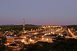
The first settlement in the Corbin area was known as Lynn Camp Station. The first post office was called Cummins, for community founder Nelson Cummins. It was discovered in 1885 that both Cummins and Lynn Camp were already in use as names for Kentucky post offices, and postmaster James Eaton was asked to select another name. He chose Corbin for the Rev. James Corbin Floyd, a local minister. [5] The town was incorporated under that name in 1905.

Corbin has a troubled racial past, including a race riot in late October 1919 in which a white mob forced nearly all the town's 200 black residents onto a freight train out of town and a sundown town policy until the late 20th century. [6] The event is the subject of a 1991 documentary, Trouble Behind. In October 2019, city leaders marked the riot's centennial with a proclamation acknowledging the riot and former sundown town policy. [7]

For most of its history, the urbanized areas of Corbin in Laurel County were not incorporated into the city limits due to a state law prohibiting cities from being in more than two counties. However, a 2021 change to state law allowed cities to voluntarily annex property in a third county if the city already provides public infrastructure to that property. [8] In March 2022, the Corbin City Commission approved an annexation request for a property in Laurel County. [9]

Geography

According to the United States Census Bureau, Corbin has a total area of 7.9 sq mi (20 km2), with only a tiny fraction of 0.044 sq mi (0.11 km2), or 0.56%, consisting of water.

Corbin lies in the Cumberland Plateau region of Appalachia in southeastern Kentucky, along Interstate 75 and U.S. Route 25W. I-75 provides access to the city from exit 25, leading north 89 miles (143 km) to Lexington and south 86 miles (138 km) to Knoxville, Tennessee. U.S. 25W runs through the center of town, leading north 14 miles (23 km) to London (via U.S. Route 25) and south 21 miles (34 km) to Williamsburg.

The Pine Mountain Overthrust Fault, a geologic fault system several miles to the east, produces occasional tremors, the most recent in 2008.

Climate

Corbin exhibits a humid subtropical climate, typical of southeastern Kentucky. The region experiences four distinct seasons. Winters are cool to cold, with mild periods. Summers are generally hot and humid, with variable spring and fall seasons. Precipitation is common year-round but more prevalent in the summer months—the surrounding mountains somewhat moderate Corbin's climate.

Climate data for Corbin, Kentucky
MonthJanFebMarAprMayJunJulAugSepOctNovDecYear
Record high °F (°C)74
(23)
81
(27)
87
(31)
90
(32)
91
(33)
101
(38)
102
(39)
97
(36)
92
(33)
82
(28)
78
(26)
102
(39)
Mean daily maximum °F (°C)44
(7)
49
(9)
58
(14)
68
(20)
75
(24)
83
(28)
86
(30)
85
(29)
79
(26)
69
(21)
58
(14)
48
(9)
66.8
(19.3)
Mean daily minimum °F (°C)25
(−4)
28
(−2)
36
(2)
43
(6)
52
(11)
61
(16)
66
(19)
64
(18)
57
(14)
44
(7)
36
(2)
29
(−2)
45
(7)
Record low °F (°C)−25
(−32)
−11
(−24)
−12
(−24)
19
(−7)
28
(−2)
34
(1)
45
(7)
44
(7)
32
(0)
18
(−8)
2
(−17)
−17
(−27)
−25
(−32)
Average precipitation inches (mm)4.01
(102)
3.72
(94)
4.61
(117)
4.01
(102)
4.69
(119)
4.24
(108)
4.39
(112)
3.36
(85)
3.37
(86)
2.80
(71)
3.90
(99)
4.31
(109)
47.41
(1,204)
Source: The Weather Channel. [10]

Demographics

Historical population
CensusPop.Note
1900 1,544
1910 2,58967.7%
1920 3,40631.6%
1930 8,036135.9%
1940 7,893−1.8%
1950 7,744−1.9%
1960 7,119−8.1%
1970 7,4745.0%
1980 8,0758.0%
1990 7,419−8.1%
2000 7,7424.4%
2010 7,304−5.7%
2020 7,8567.6%
2022 (est.)7,856 [11] 0.0%
U.S. Decennial Census [12]

Corbin is near the center of the Corbin, Kentucky micropolitan area, whose current boundaries were established in 2023 by the U.S. Office of Management and Budget in coordination with the United States Census Bureau. [13] Previously, the London micropolitan area had consisted solely of Laurel County, while the Whitley County portion of Corbin was the principal city of its own micropolitan area that consisted solely of that county. Both entities were in turn the components of a statistical entity officially known as the "Corbin–London, KY Combined Statistical Area". [14] [15] The CSA had a combined population of 94,486 at the 2010 census. [16] The Knox County portion of Corbin was outside the former Corbin–London statistical area but is now included in the redefined London micropolitan area.

As of the 2010 census [16] there were 7,304 people, 3,093 households, and 1,903 families residing in the city. The population density was 920.1 inhabitants per square mile (355.3/km2). There were 3,507 housing units at an average density of 441.8 per square mile (170.6/km2). The racial makeup of the city was 97.41% White (96.69% non-Hispanic), 0.26% African American, 0.31% Native American or Alaska Native, 0.64% Asian, 0.26% from other races, and 1.11% from two or more races. No Pacific Islanders lived in the city in 2010. Hispanics or Latinos of any race were 1.19% of the population.

There were 3,093 households, out of which 29.8% had children under the age of 18 living with them, 41.3% were married couples living together, 16.0% had a female householder with no husband present, 4.2% had a male householder with no wife present, and 38.5% were non-families. 34.8% of all households were made up of individuals, and 16.3% had someone living alone who was 65 years of age or older. The average household size was 2.27, and the average family size was 2.91.

The age distribution was 22.5% under 18, 8.5% from 18 to 24, 22.9% from 25 to 44, 25.3% from 45 to 64, and 20.8% who were 65 or older. The median age was 41.6 years. For every 100 females, there were 80.2 males. For every 100 females age 18 and over, there were 75.8 males.

Income data from the 2010 Census for Kentucky locations have not yet been released. As of the 2000 Census, the median income for a household in the city was $22,203. The median income for a family was $32,784. Males had a median income of $27,323 versus $17,568 for females. The per capita income for the city was $14,200. About 15.5% of families and 21.0% of the population were below the poverty line, including 24.0% of those under age 18 and 16.4% of those age 65 or over.

Economy

Initially provided by L&N Railroad, rail transport was the backbone of the local economy in the first half of the 20th century. While the railroad (presently CSX) continues to play an important role, the decline of the rail industry in the latter half of the 20th century, as well as the loss of some manufacturing jobs, has prompted the community to begin diversifying its economy.

Culture

Each year in early August, Corbin hosts a festival called NIBROC (Corbin spelled backward) featuring open-air concerts, carnival attractions, a beauty pageant, parade, and other events. The festival is featured, if anachronistically, in the play Last Train to Nibroc by Arlene Hutton. [17] (Though the play is set in the 1940s, the festival itself only dates to 1952.) NIBROC often features free performances by popular musical acts such as 38 Special, Foghat, Joan Jett and the Blackhearts, Kansas, The Marshall Tucker Band, Percy Sledge, Rick Springfield, Starship, Styx and The Turtles. In episode 10 of the American reality-documentary television series On the Road with Austin & Santino on Lifetime entitled "We Love a Parade", the fashion designers visit Corbin to custom-design a dress for a local woman participating in the NIBROC parade.

Despite being in dry counties (Knox and Whitley), the city of Corbin allows full retail alcohol sales, following a successful local option election on February 14, 2012. The city had previously voted in 2004 to allow sales of alcohol by the drink in larger restaurants. [18]

Corbin has an association with Kentucky Fried Chicken, having been the location of the chain's first restaurant, opened in 1930. Corbin appears in the animated cartoon South Park's episode "Medicinal Fried Chicken", wherein Eric Cartman visits the town to meet with Harland Sanders. Corbin is depicted as located in a lush rain forest in a parody of the 1983 film Scarface , wherein Tony Montana and Omar Suarez visit Bolivia to meet with a drug kingpin. [19]

Government

Corbin is governed by a mayor and city commission and a city manager who runs the departments' day-to-day operations. Currently, Marlon Sams is the city manager. Since it does not have a mayor/alderman form of government, Corbin is considered home rule-class under Kentucky's city classification system that took effect in 2015. Susie Razmus is the current mayor. Trent Knuckles, David Grigsby Hart, Ed Tye, and Andrew Pennington are its four current commissioners.[ when? ] [20]

Corbin is one of the few cities in Kentucky that lie in two counties—Whitley and Knox. Many built-up areas in neighboring Laurel County have a Corbin postal address but lie outside the city limits. This arrangement has created some problems with taxes and census records. The city receives a portion of the occupational tax collected in Whitley County. However, Knox County has refused to give Corbin any tax collected there. On March 10, 2008, the City Commission voted to file a lawsuit against Knox County to receive a portion of the tax collected within city limits. [21] On May 23, 2014, the Kentucky Court of Appeals ruled that the "Stivers amendment", passed as part of KY HB 499 "Tax Amnesty" legislation in 2012, did not violate the state's constitution. The measure essentially canceled the effect of court rulings that would have enabled Corbin to keep all the revenue from the tax generated inside the city limits. Corbin's mayor, Willard McBurney, vowed to carry the fight to the state Supreme Court. [22]

Corbin is in Kentucky's 5th congressional district.

Education

Corbin, like many communities of its size in southeastern Kentucky, has an independent school system (in Kentucky, a public school system not affiliated with a county; most such districts are associated with individual cities). The district was officially established in 1916, and the 100th class graduated in 2017. The Corbin Independent School District includes:

The community and school system place considerable emphasis on the success of academics and high school athletic teams. Corbin "Redhound" sports are important social events within the community.

In 2004, Eastern Kentucky University opened an extension campus in Corbin.

The annual Battle for the Brass Lantern, a college football rivalry game between the University of the Cumberlands and Union College, was played at Corbin High School's stadium in 2006 and 2007, as a neutral field roughly equidistant from the two campuses. The rivalry dates to 1905. [23]

Corbin was formerly home to Saint Camillus Academy, a private pre-K-8 Catholic school affiliated with the Diocese of Lexington. Established in 1908 by the Sisters of Divine Providence, the school has been successful as both a boarding school for national and international students and as a Montessori school. Its original schoolhouse, built in 1913, was demolished in summer 2008. The new school building is still situated atop a prominent hill overlooking the town, providing a striking backdrop to the streets of downtown Corbin. The school closed in 2012 after 99 years of service. The property and grounds of the school were sold to the Corbin School System to house a new Corbin Middle School due to the rapidly increasing student population and age of the current building.

Corbin has a lending library, the Corbin Public Library. [24]

Transportation

Corbin straddles Interstate 75 and U.S. Highway 25 (which splits into US 25E and US 25W in North Corbin). The town is served by the CSX rail line.

Sites of interest

Cumberland Falls, 2005 Cumberland Falls 2005 05 20a.jpeg
Cumberland Falls, 2005
Corbin, Kentucky skyline, 2006 Corbin-ky-skyline2.jpg
Corbin, Kentucky skyline, 2006

Media

Newspapers

[26]

Radio

TV

Notable people

Related Research Articles

<span class="mw-page-title-main">Whitley County, Kentucky</span> County in Kentucky, United States

Whitley County is a county located in the southeastern part of the U.S. state of Kentucky. As of the 2020 census, the population was 36,712. Its county seat is at Williamsburg, though the largest city is Corbin, and the county's District Court sits in both cities. Whitley County is included in the London, KY Micropolitan Statistical Area.

<span class="mw-page-title-main">McCreary County, Kentucky</span> County in Kentucky, United States

McCreary County is a county located in the U.S. state of Kentucky. As of the 2020 census, the population was 16,888. Its county seat is Whitley City. The county is named for James B. McCreary, a Confederate war soldier and two-time Governor of Kentucky. During his second term as governor, McCreary County was created by the Legislature and was named in his honor.

<span class="mw-page-title-main">Laurel County, Kentucky</span> County in Kentucky, United States

Laurel County is a county located in the southeastern portion of the U.S. state of Kentucky. As of the 2020 census, the population was 62,613. Its county seat is London. After a special election in January 2016 alcohol sales are permitted only in the city limits of London. The ordinance went into effect on March 27, 2016, 60 days after results of the election. Laurel County is included in the London, KY Micropolitan Statistical Area.

<span class="mw-page-title-main">Bell County, Kentucky</span> County in Kentucky, United States

Bell County is a county located in the southeast part of the U.S. state of Kentucky. As of the 2020 census, the population was 24,097. Its county seat is Pineville and its largest city is Middlesboro. The county was formed in 1867, during the Reconstruction era from parts of Knox and Harlan counties and augmented from Knox County in 1872. The county is named for Joshua Fry Bell, a US Representative. It was originally called "Josh Bell", but on January 31, 1873, the Kentucky legislature shortened the name to "Bell",

<span class="mw-page-title-main">Pineville, Kentucky</span> City in Kentucky, United States

Pineville is a home rule-class city in Bell County, Kentucky, United States. It is the seat of its county. The population was 1,732 as of the 2010 census. It is located on a small strip of land between the Cumberland River and Pine Mountain.

<span class="mw-page-title-main">London, Kentucky</span> City in Kentucky, United States

London is a home rule-class city in Laurel County, Kentucky, in the United States. It is the seat of its county. The population was 8,053 at the time of the 2020 census. It is the second-largest city named "London" in the United States and the fourth-largest in the world. It is part of the London, Kentucky micropolitan area. Of the seventeen micropolitan areas in Kentucky, London is the largest; the London micropolitan area's 2010 Census population was 126,368. London is also home to the annual World Chicken Festival that celebrates the life of Colonel Sanders and features the world's largest skillet.

<span class="mw-page-title-main">Vanceburg, Kentucky</span> City in Kentucky, United States

Vanceburg is a home rule-class city in Lewis County, Kentucky, United States, along the Ohio River. The population was 1,428 at the 2020 census. It is the county seat of Lewis County.

<span class="mw-page-title-main">Williamsburg, Kentucky</span> City in Kentucky, United States

Williamsburg is a home rule-class city in and the county seat of Whitley County, on the southeastern border of Kentucky, United States. The population was 5,326 at the 2020 census. Developed along the Cumberland River, the city was founded in 1818 and named after William Whitley.

<span class="mw-page-title-main">North Corbin, Kentucky</span> Census-designated place in Kentucky, United States

North Corbin is a census-designated place (CDP) in Laurel and Knox counties in the U.S. state of Kentucky. The population was 1,727 at the 2020 census down from 1,773 at the 2010 census. The census bureau also lists the Laurel County portion of North Corbin as a CCD with a population of 10,729.

<span class="mw-page-title-main">U.S. Route 25E</span> Highway in Tennessee and Kentucky, United States

U.S. Route 25E (US 25E) is the eastern branch of US 25 from Newport, Tennessee, where US 25 splits into US 25E and US 25W, to North Corbin, Kentucky, where the two highways rejoin. The highway, however, continues as US 25E for roughly two miles (3.2 km) until it joins Interstate 75 (I-75) in the Laurel County community of North Corbin at exit 29. The highway serves the Appalachia regions of Kentucky's Cumberland Plateau and the Ridge-and-Valley section of East Tennessee, including the urbanized areas of Corbin and Middlesboro in Kentucky and Morristown in Tennessee.

<span class="mw-page-title-main">U.S. Route 25W</span> Highway in Tennessee and Kentucky, United States

U.S. Route 25W (US 25W) is the western branch of US 25 from Newport, Tennessee, where US 25 splits into US 25E and US 25W, to North Corbin, Kentucky, where the two highways rejoin.

<span class="mw-page-title-main">Kentucky Route 90</span> State highway in Kentucky, USA

Kentucky Route 90 is a major east–west state highway in southern Kentucky. The route is 134.734 miles (216.833 km) long, and it traverses Barren, Metcalfe, Cumberland, Clinton, Wayne, Pulaski, McCreary and Whitley Counties in southern Kentucky. It runs from the KY 70 junction near Interstate 65 in Cave City to US 25W about 8 miles (13 km) from Interstate 75.

<span class="mw-page-title-main">Knox County, Kentucky</span> County in Kentucky, United States

Knox County is a county located in Appalachia near the southeastern corner of the U.S. state of Kentucky. As of the 2020 census, the population was 30,193. Its county seat is Barbourville. The county is named for General Henry Knox. It is one of the few coal-producing counties in Kentucky that has not suffered massive population loss. Knox County is included in the London, KY Micropolitan Statistical Area.

<span class="mw-page-title-main">Kentucky Route 26</span> State highway in Kentucky, United States

Kentucky Route 26 serves as a shorter alternate route for traffic using US 25W between Williamsburg and Corbin in Whitley County. The southern terminus of KY 26 is at US 25W north of Williamsburg, and its northern terminus is also at US 25W, this time in Corbin. Traveling from Williamsburg, while US 25W treks northwesterly past I-75 in the direction of Cumberland Falls State Resort Park, then comes back in a northeasterly direction, crossing I-75 again on the way into Corbin, KY 26 stays on the east side of I-75 for its entirety, providing a more direct path between the two cities.

<span class="mw-page-title-main">Kentucky Route 92</span> State highway in Kentucky, USA

Kentucky Route 92 (KY 92) is a 112.485-mile-long (181.027 km) state highway Kentucky. The route is split into two segments by Lake Cumberland and is one of a few state routes in Kentucky with two discontinuous segments on both sides of a body of water. The western segment, which is 17.221-mile-long (27.715 km), runs from Kentucky Route 55 west of Joppa to a dead end on Lake Cumberland south of Jamestown via Joppa, Montpelier, Esto, and Jamestown. The eastern segment, which is 95.264-mile-long (153.313 km), runs from a boat ramp on Lake Cumberland northwest of Monticello to U.S. Route 25E west of Fourmile via Monticello, Barrier, Stearns, Carpenter, Timsley, and Ingram.

<span class="mw-page-title-main">Corbin, KY Micropolitan Statistical Area</span>

The Corbin Micropolitan Statistical Area, as defined by the United States Census Bureau, is an area consisting of Whitley County, Kentucky, anchored by the Whitley County portion of the city of Corbin. As of the 2000 census, the μSA had a population of 35,865.

<span class="mw-page-title-main">London, KY Micropolitan Statistical Area</span>

The London, KY Micropolitan Statistical Area is a United States Census Bureau defined Micropolitan Statistical Area located in the vicinity of London, Kentucky. The London Micropolitan Statistical Area encompasses Laurel County entirely. The Micropolitan Statistical Area had a population of 52,715 at the 2000 Census. A July 1, 2009 U.S. Census Bureau estimate placed the population at 57,749.

<span class="mw-page-title-main">Corbin, Kentucky micropolitan area</span> Micropolitan area in Eastern Kentucky

The Corbin, Kentucky Micropolitan Area Micropolitan Area (μSA) is made up of four counties in the Eastern Coalfield region of Kentucky. Before 2013, the area was officially known as the Corbin–London, KY Combined Statistical Area, and consisted of the Corbin Micropolitan Statistical Area and the London Micropolitan Statistical Area. The Corbin micropolitan area consisted of Whitley County, and the London micropolitan area consisted of Laurel County.

WVTN-LD is a low-powered television station that is licensed to and serving Corbin, Kentucky. The station is owned by Victory Training School Corporation, and is broadcasting religious programming. Its transmitter is located in southwestern Laurel County along Kentucky Route 312 off of Interstate 75 northwest of Corbin. WVTN-LD shares their studios and broadcasting facilities with sister radio station WVCT. The facilities are located at 968 West City Dam Road in Keavy, Kentucky.

<span class="mw-page-title-main">Kentucky Route 3041</span> Highway in Kentucky, United States

Kentucky Route 3041 (KY 3041) is a state highway in the southeastern part of the U.S. state of Kentucky. Known as the Corbin Bypass, the route runs 5.700 miles (9.173 km) from U.S. Route 25W east and north to US 25E within Corbin. KY 3041 provides a southeastern bypass of the center of Corbin through eastern Whitley County and western Knox County. The bypass was planned starting in the late 1980s and was constructed in three stages in the mid-1990s. KY 3041 eased congestion in downtown Corbin and stimulated educational and industrial development in the late 1990s.

References

  1. "2020 U.S. Gazetteer Files". United States Census Bureau. Retrieved March 18, 2022.
  2. 1 2 U.S. Geological Survey Geographic Names Information System: Corbin, Kentucky
  3. "Annual Estimates of the Resident Population for Incorporated Places in Kentucky: April 1, 2020 to July 1, 2022". United States Census Bureau. Retrieved May 26, 2023.
  4. "Summary and Reference Guide to House Bill 331 City Classification Reform" (PDF). Kentucky League of Cities. Retrieved December 30, 2014.
  5. Corbin-Times Tribune, 1906. James Eaton is quoted as saying he named the town for Rev. Floyd "the finest man I know."
  6. NPR.
  7. Kenning, Chris (September 14, 2020). "Former Kentucky 'sundown' town shadowed by racist past". The Courier-Journal . Louisville, Kentucky. Retrieved April 22, 2021.
  8. AN ACT relating to local government (PDF). March 28, 2021. Retrieved March 28, 2022.
  9. Cox, Erin (March 24, 2022). "Laurel County business to be annexed into Corbin city limits; Dispatcher pay increased". Corbin Times Tribune. Corbin, Kentucky. Retrieved March 28, 2022.
  10. "MONTHLY AVERAGES for Corbin, KY". The Weather Channel . Retrieved May 27, 2010.
  11. "Annual Estimates of the Resident Population for Incorporated Places in Kentucky: April 1, 2020 to July 1, 2022". United States Census Bureau. Retrieved May 26, 2023.
  12. "Census of Population and Housing". Census.gov. Retrieved June 4, 2015.
  13. "OMB Bulletin No. 23-01" (PDF). www.whitehouse.gov. July 21, 2023. pp. 59, 138. Retrieved January 21, 2024.
  14. "MICROPOLITAN STATISTICAL AREAS AND COMPONENTS, December 2006, WITH CODES". United States Census Bureau. Office of Management and Budget. May 11, 2007. Archived from the original on June 29, 2007. Retrieved August 1, 2008.
  15. "COMBINED STATISTICAL AREAS AND COMPONENT CORE BASED STATISTICAL AREAS, December 2006, WITH CODES". United States Census Bureau. Office of Management and Budget. May 11, 2007. Archived from the original on June 29, 2007. Retrieved August 1, 2008.
  16. 1 2 "U.S. Census website". United States Census Bureau . Retrieved January 31, 2008.
  17. Bellafante, Ginia (April 11, 2007). "Three Plays Portray a Couple Bound by Love and Conflict". New York Times.
  18. Noble, Jeff (February 15, 2012). "Corbin says 'Yes'". The Times-Tribune . Corbin, Kentucky. Retrieved April 8, 2012.
  19. "Corbin gets mention in 'South Park' episode". The Times-Tribune.com. April 2, 2010. Retrieved July 22, 2015.
  20. "Shelton, Tye re-elected, Joe White loses seat". The Times-Tribune.com. November 7, 2012. Retrieved July 22, 2015.
  21. Swindler, Samantha (March 11, 2008). "Corbin to sue Knox County". Times-Tribune . p. 1A.
  22. Knuckles, Trent (June 11, 2014). "Corbin loses occupational tax case appeal". The News Journal. Corbin, KY, USA. Archived from the original on July 17, 2015. Retrieved July 17, 2015.
  23. Corbin/Williamsburg News Journal Archived March 2, 2012, at the Wayback Machine , Corbin, KY: Moving to Corbin; Battle of Lantern will be played at Campbell Field. By Jim McAllister. July 20, 2006.
  24. "Kentucky Public Library Directory". Kentucky Department for Libraries and Archives. Archived from the original on January 11, 2019. Retrieved June 7, 2019.
  25. "History". Cumberland Falls State Resort Park. Kentucky Department of Parks. Archived from the original on June 4, 2015. Retrieved July 17, 2015.
  26. "The Times-Tribune".
  27. DiLullo, Mikey. "Five things to know about Bengals receiver Trent Taylor, former Evangel Christian Academy star". The Times. Retrieved February 21, 2022.

Further reading

Historical