Cumberland Gap National Historical Park

Last updated
Cumberland Gap National Historical Park
IUCN Category V (Protected Landscape/Seascape)
Pinnacle overlook.jpg
View from the Pinnacle Overlook toward the southwest, overlooking Fern Lake and the surrounding park, 2009
CumberlandGapMap.jpg
Location Kentucky, Tennessee, and Virginia, United States
Nearest city Cumberland Gap, Tennessee
Coordinates 36°36′15″N83°41′14″W / 36.60417°N 83.68722°W / 36.60417; -83.68722 Coordinates: 36°36′15″N83°41′14″W / 36.60417°N 83.68722°W / 36.60417; -83.68722
Area20,508 acres (8,299 ha)
Visitation704,598 (2019) [1]
Website www.nps.gov/cuga
NRHP reference No. 66000353 [2]
Added to NRHPOctober 15, 1966

The Cumberland Gap National Historical Park is a United States National Historical Park located at the border between Kentucky, Tennessee, and Virginia, centered on the Cumberland Gap, a natural break in the Appalachian Mountains.

Contents

The park lies in parts of Bell and Harlan counties in Kentucky, Claiborne County in Tennessee, and Lee County in Virginia. The park contains the Kentucky-Virginia-Tennessee tripoint, accessible via trail. [3]

The town of Cumberland Gap, Tennessee, is located inside of the park's territory. [3]

The Cumberland Gap Visitor Center is located on U.S. Highway 25E just southeast of the city of Middlesboro, Kentucky, and just northwest of the Cumberland Gap Tunnel and the town of Cumberland Gap, Tennessee. The visitor center features a museum with interactive exhibits about the Gap's role as a transportation corridor, an auditorium that shows films about the area's cultural and natural history, a book store and the Cumberland Crafts gift shop with crafts from Appalachia. [4]

Physical geography

The park covers 24,000 acres (9,700 ha) and is among the largest national parks in the eastern United States. [5] :29 As of 2010, 14,091 acres (5,702 ha) of this was designated as Recommended Wilderness. [6] :v Elevation varies from a low of 1,100 feet (340 m) to a high of 3,500 feet (1,100 m). [7] :13

The park runs along the Cumberland Mountains, stretching about 20 miles (32 km) with an average width of 1.6 miles (2.6 km). [8] The park straddles a tri-state area encompassing land from Kentucky, Tennessee, and Virginia. [5] :29 It includes the area of the Wilderness Road running through the passage across the Cumberland Plateau and through the Cumberland Gap, an important geological feature that facilitated travel for American settlers and Native Americans. [7] :13 [9] [8] It includes 24 known cave features ranging in size from around 20 feet (6.1 m) to more than 16 miles (26 km) in length. [6] :10 [10]

There are a number of large cliff systems in the park, the most prominent of which is the 500 feet (150 m) cliffs of White Rocks, located in the eastern portion of the area. [6] :34 [10] At the northeastern end, the park sits adjacent to the Sillalah Creek Wildlife Management Area and the Martin's Fork Wildlife Management Area and State Natural Area. [11] [6] :27

The climate of the area is mild, with hot and humid summers and mild winters, and an average annual temperature of 54 °F (12 °C). [7] :15

Winter view from beneath the White Rocks cliffs, in the far eastern portion of the park CumberlandGapWhiteRocks.jpg
Winter view from beneath the White Rocks cliffs, in the far eastern portion of the park

Hydrology

The park contains over 62 miles (100 km) of streams. [7] :xvii With the exception of one, Little Yellow Creek, all of these originate from within the park, with those to the north of the main ridge flowing into the Cumberland River, and those to the south flowing into the Powell River. [7] :16 Overall water quality in the park is good to fair, with some areas falling below recommended pH levels, likely due to natural causes, and others exceeding recommended levels of microorganisms, possibly due to contamination from campgrounds. [7] :46

Ecology

The area of the park is 97% forested and contains 970 species of vascular plants, 90 of which are classified as sensitive or rare species. [7] :xvii These include 108 non-native species of plants, and 31 considered to be highly aggressive invasive plants. [7] :55 [lower-alpha 1]

The park is home to at least 145 species of birds, and 40 species of mammals, including the near-threatened bat, Myotis sodalis (Indiana bat). [7] :xvii The streams in the park house around 27 species of fish, including Chrosomus cumberlandensis (blackside dace), federally listed as an endangered species. Additionally, surveys have identified at least 36 species of reptiles and amphibians. [7] :xvii

Ecosystems in the park are threatened by a number of insect infestations from non-native pest species, including Dendroctonus frontalis (southern pine beetle), and Adelges tsugae (hemlock woolly adelgid). The species Agrilus planipennis (emerald ash borer) and Lymantria dispar dispar (gypsy moth) also represent imminent threats from surrounding areas. [7] :73

History

Vice President Richard Nixon at the Pinnacle Interpretive Shelter, attending the dedication of the park's Visitor Center (Mission 66 project), July 1959. HPC-001317 (26975446814).jpg
Vice President Richard Nixon at the Pinnacle Interpretive Shelter, attending the dedication of the park's Visitor Center (Mission 66 project), July 1959.
National Park Service map of horse trails within the park NPS cumberland-gap-horse-trail-map.jpg
National Park Service map of horse trails within the park

Business leaders from Middlesboro, Kentucky, meeting in Cincinnati for the Appalachian Logging Conference, proposed a Lincoln National Park, centered around Fern Lake as early as 1922. [7] :18 [12] However, two bills introduced into the Kentucky State Legislature the following year by State Congressman John Robison both failed. Later attempts in 1929 sought to create memorials for Civil War battles fought in the area, and also failed. In 1938, the National Park Service agreed to support a park if the lands were donated to form one, and the Cumberland Gap National Historical Park Association was created, sparking more unsuccessful attempts in Kentucky, and then passage of a bill in Virginia in 1939 that paved the way for federal authorization. [7] :18 [12]

The park was established on June 11, 1940, by Franklin Roosevelt in order to "commemorate the story of the first doorway of the west". [9] [8] [6] :v It was authorized by Congress to occupy an area not to exceed 50,000 acres (20,000 ha). [6] :v The surrounding states purchased and deeded the land of the park to the federal government in 1955, and the official opening took place in 1959. [13] [12]

In 1992, the park purchased the area surrounding Gap Cave, which had previously been privately owned. [6] :10 By 1996, the park had undergone some $280 million in improvements, including construction of the Cumberland Gap Tunnel. [6] :10

Toward the southern end of the park lies Fern Lake, created by an earthen dam in 1890, which provides water to the nearby town of Middlesboro, Kentucky. [14] :19 The area surrounding the lake was purchased by the park in four phases following the passage of the Fern Lake Conservation and Recreation Act, increasing the overall size of the park by 20%:

As of 2010 there were plans to acquire an additional 600 acres (240 ha) of land surrounding the lake. [6] :10 As of 2018, the park had an estimated $15 million in deferred maintenance. [16]

Accommodations

The exterior of the visitor center in 2008 Cumberland Gap National Historical Park visitors center.jpg
The exterior of the visitor center in 2008

The park includes a visitor center, renovated in 2004, which features a museum and auditorium, providing exhibits on the areas cultural and natural history, as well as book and gift shops. [14] :13

Guided tours of the Hensley Settlement and Gap Cave are provided from the tourist center. [14] :17 Around 3.5 miles (5.6 km) from the center, along the Skyland Road, lies the Pinnacle Overlook, which, at an elevation of 2,440 feet (740 m), overlooks the gap and the surrounding country. [14] :19 [17]

There are 85 miles (137 km) of hiking trails, ranging from shorter routes such as the 2.6 miles (4.2 km) Sugar Run Trail, to the 21 miles (34 km) Ridge Trail, which spans the park and reaches an elevation of 3,513 feet (1,071 m). [18] The nearby Wilderness Road Campground includes 160 campsites. [17] No hunting is permitted within the park. [6] :30

Tri-State Peak is located in the park, and is accessible by trail. A marker designating the tripoint of the states of Kentucky, Tennessee, and Virginia, is located at the peak of the mountain. [19]

Tourism

The park saw 737,547 visitors in 2017, according to statistics by the National Park Service. [1] According to one federal study, in 2013 visitor spending amounted to $46 million in nearby communities, supporting 639 local jobs. [20] Peak rates of visitation normally occur during the seasons of spring, summer and fall. [7] :xvii

Recognition

In 2017, the park received the Keeper of the Light Award from the Southeast Region of the National Park Service, which recognizes excellence in education. [21] In 2016, the United States Mint released a commemorative quarter as part of the America the Beautiful series honoring the park. [22]

See also

Notes

  1. A 2006 study listed the six plants which would be most beneficial if removed from the park as being: Japanese stiltgrass, autumn olive, Johnsongrass, princesstree, tree of heaven, and Mimosa. [7] :55

Related Research Articles

<span class="mw-page-title-main">Cumberland Falls</span> Waterfall in the U.S. state of Kentucky

Cumberland Falls, sometimes called the Little Niagara, the Niagara of the South, or the Great Falls, is a waterfall on the Cumberland River in southeastern Kentucky. Spanning the river at the border of McCreary and Whitley counties, the waterfall is the central feature of Cumberland Falls State Resort Park and is part of the Office of Kentucky Nature Preserves designated Wild River System.

<span class="mw-page-title-main">Lee County, Virginia</span> County in Virginia, United States

Lee County is the westernmost county in the U.S. Commonwealth of Virginia. As of the 2020 census, the population was 22,173. Its county seat is Jonesville.

<span class="mw-page-title-main">Bell County, Kentucky</span> County in Kentucky, United States

Bell County is a county located in the southeast part of the U.S. state of Kentucky. As of the 2020 census, the population was 24,097. Its county seat is Pineville. The county was formed in 1867, during the Reconstruction era from parts of Knox and Harlan counties and augmented from Knox County in 1872. The county is named for Joshua Fry Bell, a US Representative. It was originally called "Josh Bell", but on January 31, 1873, the Kentucky legislature shortened the name to "Bell",

<span class="mw-page-title-main">Middlesboro, Kentucky</span> City in Kentucky, United States

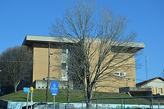
Middlesboro is a home rule-class city in Bell County, Kentucky, United States. The population was 10,334 at the 2010 U.S. census, while its micropolitan area had a population of 69,060.

<span class="mw-page-title-main">Cumberland Gap, Tennessee</span> Town in Claiborne County, Tennessee, United States

Cumberland Gap is a town in Claiborne County, Tennessee, United States. Its population was 494 at the 2010 census, and estimated to be 490 in 2019. The town is located below the Cumberland Gap, a historic mountain pass for which is the town's namesake, and inside of the boundaries of Cumberland Gap National Historical Park.

<span class="mw-page-title-main">Daniel Boone National Forest</span> National forest in Kentucky

The Daniel Boone National Forest is a national forest in Kentucky. Established in 1937, it includes 708,000 acres (287,000 ha) of federally owned land within a 2,100,000 acres (850,000 ha) proclamation boundary. The name of the forest was changed in 1966 in honor of the explorer Daniel Boone.

<span class="mw-page-title-main">Cumberland River</span> River in Kentucky and Tennessee, United States

The Cumberland River is a major waterway of the Southern United States. The 688-mile-long (1,107 km) river drains almost 18,000 square miles (47,000 km2) of southern Kentucky and north-central Tennessee. The river flows generally west from a source in the Appalachian Mountains to its confluence with the Ohio River near Paducah, Kentucky, and the mouth of the Tennessee River. Major tributaries include the Obey, Caney Fork, Stones, and Red rivers.

<span class="mw-page-title-main">Cumberland Mountains</span> Mountain range in the southeastern United States

The Cumberland Mountains are a mountain range in the southeastern section of the Appalachian Mountains. They are located in western Virginia, southwestern West Virginia, the eastern edges of Kentucky, and eastern middle Tennessee, including the Crab Orchard Mountains. Their highest peak, with an elevation of 4,223 feet (1,287 m) above mean sea level, is High Knob, which is located near Norton, Virginia.

<span class="mw-page-title-main">Middlesboro crater</span>

The Middlesboro crater is a meteorite crater in Kentucky, United States. It is named after the city of Middlesborough, which today occupies much of the crater.

Thomas Walker was a physician, planter and explorer in colonial Virginia who served multiple terms in the Virginia General Assembly, and whose descendants also had political careers. Walker explored Western Colony of Virginia in 1750, 19 years before the arrival of Daniel Boone.

<span class="mw-page-title-main">Wilderness Road</span> Historic highway in Kentucky

The Wilderness Road was one of two principal routes used by colonial and early national era settlers to reach Kentucky from the East. Although this road goes through the Cumberland Gap into southern Kentucky and northern Tennessee, the other is sometimes called the "Cumberland Road" because it started in Fort Cumberland in Maryland. Despite Kentucky Senator Henry Clay's advocacy of this route, early in the 19th century, the northern route was selected for the National Road, connecting near Washington, Pennsylvania into the Ohio Valley of northern Kentucky and Ohio.

<span class="mw-page-title-main">Cumberland Gap</span> Narrow pass through the Cumberland Mountains

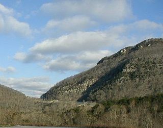
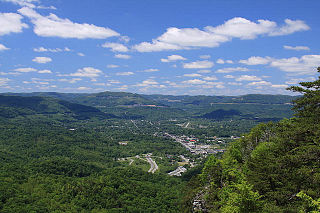
The Cumberland Gap is a pass in the eastern United States through the long ridge of the Cumberland Mountains, within the Appalachian Mountains and near the tripoint of Kentucky, Virginia, and Tennessee. At an elevation of 1,631 feet (497 m) above sea level, it is famous in American colonial history for its role as a key passageway through the lower central Appalachians.

<span class="mw-page-title-main">Cumberland Gap Tunnel</span> Tunnel under Cumberland Gap National Historic Park spanning from Tennessee to Kentucky

The Cumberland Gap Tunnel is a dual-bore, four lane vehicular tunnel that carries U.S. Route 25E under Cumberland Gap National Historical Park near the intersection of Kentucky, Tennessee, and Virginia. The tunnel consists of two separate bores which carry four lanes of traffic between Cumberland Gap, Tennessee and Middlesboro, Kentucky. It is one of only two mountain vehicular tunnels in the United States that cross a state line, the other being the East River Mountain Tunnel on Interstate 77 and U.S. Route 52 between Virginia and West Virginia. The tunnel opened to traffic in 1996 and replaced a section of highway through the Cumberland Gap that had earned the nickname "Massacre Mountain" due to its hazardous design and high rate of traffic accidents.

<span class="mw-page-title-main">U.S. Route 25E</span> Highway in Tennessee and Kentucky, United States

U.S. Route 25E is the eastern branch of U.S. Route 25 from Newport, Tennessee, where US 25 splits into US 25E and US 25W, to North Corbin, Kentucky, where the two highways rejoin. The road, however, continues as US 25E for roughly 2 miles (3.2 km) until it joins Interstate 75 in the Laurel County community of North Corbin at exit 29. The entire route serves as a arterial expressway for long-distance travelers and truckers connecting central Appalachia to the Great Lakes and Eastern Seaboard regions of the U.S. via access to I-75, I-81, and proximity to I-26 and I-40.

<span class="mw-page-title-main">Tri-State Peak</span>

Tri-State Peak is a mountain located in the Cumberland Gap National Historical Park, near the "saddle" of the gap. It gets its name from being on the tripoint of the states of Kentucky, Tennessee, and Virginia.

<span class="mw-page-title-main">Graham Cave State Park</span> State park in Missouri, United States

Graham Cave State Park is a state park in the U.S. state of Missouri consisting of 369 acres (149 ha) located in Montgomery County. The park's namesake, Graham Cave, is a cave in St. Peter sandstone with an entrance 120 feet (37 m) wide and 60 feet (18 m) high and an extent of about 100 feet (30 m) into the hillside. The cave protects an historically important Pre-Columbian archaeological site dating back to as early as 10,000 years ago. Visitors are allowed up to the entrance of the cave where interpretive signs point out significant discoveries. The park includes the 82-acre (33 ha) Graham Cave Glades Natural Area which protects an area of sandstone and dolomite glades with a rich diversity of glade species. The park is adjacent to Interstate 70 from which the entrance to the cave can be glimpsed during foliage-free months.

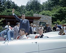
Alexander Alan Arthur was a Scottish-born engineer and entrepreneur active primarily in the southeastern United States in the latter half of the 19th century. Flamboyant, charismatic, and energetic, Arthur used his prominent American and European financial connections to fund numerous business ventures, most of which were overly ambitious and ultimately failed. A proponent of economic advancement in what became known as the New South, Arthur played a primary role in the development of the Cumberland Gap area, and in the course of his endeavors established the cities of Middlesboro, Kentucky and Harrogate, Tennessee. The community of Arthur, Tennessee, is named for him.

<span class="mw-page-title-main">Land Between the Lakes National Recreation Area</span> Protected area in Kentucky and Tennessee, U.S.

Land Between the Lakes National Recreation Area is a United States 171,280 acres (69,310 ha) national recreation area in Kentucky and Tennessee between Lake Barkley and Kentucky Lake. It was designated as a national recreation area in 1963 by President John F. Kennedy and developed using funds appropriated during the Johnson administration.

<span class="mw-page-title-main">Hensley Settlement</span> United States historic place

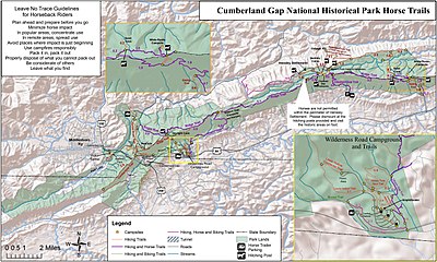
Hensley Settlement is an Appalachian living history museum on Brush Mountain, Bell County, Kentucky in the United States. The settlement is part of the Cumberland Gap National Historical Park and it is located approximately 10 miles (16 km) north of the park visitor center on Ridge Trail.

The Battle of Camp Wildcat was one of the early engagements of the American Civil War. It occurred October 21, 1861, in northern Laurel County, Kentucky during the campaign known as the Kentucky Confederate Offensive or Operations in Eastern Kentucky (1861). The battle is considered one of the first Union victories of the Civil War, and marked the second engagement of troops in the Commonwealth of Kentucky.

References

  1. 1 2 "National Park Service Visitor Use Statistics". National Park Service . Retrieved December 23, 2013.
  2. "National Register Information System". National Register of Historic Places . National Park Service. November 2, 2013.
  3. 1 2 "Cumberland Gap National Historical Park Map" (PDF). National Park Service . Retrieved September 24, 2022.
  4. "Visitor Center". National Park Service . Retrieved September 13, 2010.
  5. 1 2 Martha Evans Wiley (27 January 2014). Cumberland Gap National Historical Park. Arcadia Publishing. ISBN   978-1-4396-4458-4.
  6. 1 2 3 4 5 6 7 8 9 10 Cumberland Gap National Historical Park, General Management Plan: Environmental Impact Statement. National Park Service. 2010.
  7. 1 2 3 4 5 6 7 8 9 10 11 12 13 14 15 Sundin, Gary; Worsham, Luke; Nibbelink, Nathan P.; Mengak, Michael T.; Grossman, Gary (2013). "Natural Resource Condition Assessment for Cumberland Gap National Historical Park". National Park Service . Retrieved 17 April 2018.
  8. 1 2 3 Crawford, Matthew M.; Hunsberger, Hanna. "Geology of Cumberland Gap National Historic Park" (PDF). Kentucky Geological Survey . Retrieved 6 April 2018.
  9. 1 2 "Cumberland Gap National Historical Park". Encyclopædia Britannica . Retrieved 6 April 2018.
  10. 1 2 "Geologic Formations". National Park Service . Retrieved 13 April 2018.
  11. "Martins Fork WMA and State Natural Area" (PDF). Kentucky Department of Fish and Wildlife Resources . Retrieved 13 April 2018.
  12. 1 2 3 "Cumberland Gap and Cumberland Gap National Historical Park". Tennessee Encyclopedia. Tennessee Historical Society . Retrieved 20 April 2018.
  13. Kriplen, Nancy (September 11, 2009). "The Cumberland Gap, the Notch America Squeezed Through". The New York Times . Retrieved 6 April 2018.
  14. 1 2 3 4 Tom N. Shattuck (2005). The Cumberland Gap Area Guidebook. The Wilderness Road Company. ISBN   978-0-9677765-3-8.
  15. "Fern Lake Land Acquisition". National Park Service . Retrieved 6 April 2018.
  16. "Fact Sheet: Cumberland Gap National Historical Park". The Pew Charitable Trusts. January 25, 2018. Retrieved 20 April 2018.
  17. 1 2 "Cumberland Gap National Historical Park, KY". American Automobile Association . Retrieved 6 April 2018.
  18. Rice, Larry (2017-02-09). "Plan a trip to Cumberland Gap National Historic Park". Scouting magazine . Retrieved 6 April 2018.
  19. "Tri-State Peak". National Park Service . Archived from the original on June 1, 2009. Retrieved 13 April 2018.
  20. "Tourism to Cumberland Gap National Historical Park Creates $46 Million in Economic Benefit". National Park Service . Retrieved 6 April 2018.
  21. "Cumberland Gap National Historical Park receives prestigious award". Middlesboro Daily News. January 19, 2018. Retrieved 6 April 2018.
  22. "New quarter honors Cumberland Gap National Park". WBIR . April 11, 2016. Retrieved 6 April 2018.