
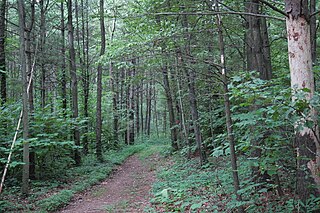
Devil's Backbone State Forest is a 558-acre (226 ha) state forest in Shenandoah County, Virginia. It lies on the slope of North Mountain in the drainage area of Cedar Creek near Star Tannery west of Strasburg. The forest was established by a grant by John and Bernice Hoffman, who owned the land since 1950.
Joseph E. Ibberson Conservation Area is a 783-acre (317 ha) Pennsylvania state park in Middle Paxton and Wayne Townships, Dauphin County, Pennsylvania in the United States.

Calvin Price State Forest is a 9,482-acre (38 km2) state forest in eastern Pocahontas and Greenbrier counties, West Virginia. The forest is the newest in West Virginia's system, having been mostly purchased in 1953 from New River Lumber Company. The forest is named for Marlinton newspaper editor, Calvin W. Price.

Coopers Rock State Forest is a 12,747-acre (52 km2) state forest in Monongalia and Preston counties in the U.S. state of West Virginia. Its southern edge abuts Cheat Lake and the canyon section of Cheat River, a popular whitewater rafting river in the eastern United States.
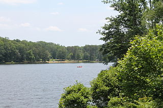
Bear Creek Lake State Park is a 326-acre (132 ha) state park located in Cumberland, Virginia, United States. It is a recreational and camping facility that surrounds an artificial 40-acre (16 ha) lake situated in the 16,000-acre (6,500 ha) Cumberland State Forest.
Sun Pass State Forest is one of six state forests managed by the Oregon Department of Forestry. The forest is located 40 miles (64 km) north of Klamath Falls, Oregon near the southeastern corner of Crater Lake National Park. It is the largest single block of Oregon state forestry land east of the Cascade Mountains. The forest is managed as part of the Klamath-Lake District, comprising 21,317 acres (86.27 km2) of the 33,739 state-owned acres within the district.

Santiam State Forest is one of six state forests managed by the Oregon Department of Forestry. The forest is located approximately 25 miles (40 km) southeast of Salem, Oregon, and includes 47,871 acres (193.73 km2) on the western slope of the Cascade Mountains in three Oregon counties: Clackamas, Linn, and Marion. It is bounded on the east by the Willamette National Forest and Mount Hood National Forest. Silver Falls State Park is located west of the forest. The rest of the land surrounding the forest belongs to the Bureau of Land Management or is privately owned. The forest is managed as part of the Department of Forestry's North Cascade District. It is the largest single block of state owned forest land in the Cascades.

The Cloquet Valley State Forest encompasses 327,098 acres (1,323.7 km2); 48,384 acres (195.8 km2) of which are Minnesota Department of Natural Resources forestry administered lands.
The Appomattox-Buckingham State Forest is a state forest located in the Piedmont of Virginia in Appomattox and Buckingham counties. Its 19,808 acres are covered with a mix of oak-hickory and pine forest. Dominant tree species include oaks, hickories, yellow poplar, red maple, and pines. It is the largest state forest in Virginia.

Jackson F. Kimball State Recreation Site is a state park in southern Oregon. The park is operated and maintained by the Oregon Parks and Recreation Department, and is located approximately 20 miles (32 km) southeast of Crater Lake National Park and 3 miles (4.8 km) north of Fort Klamath. The park was established in 1955, and covers 19 acres (7.7 ha) including the headwaters of the Wood River.
Bourassa State Forest is a 288-acre (117 ha) state forest located in Bedford County, Virginia, north of Smith Mountain Lake. It is used primarily for timber production, as an outdoor lab, and as a wildlife sanctuary. The forest is adjacent to the Smith Mountain Cooperative Wildlife Management Area.
Channels State Forest is a 4,836-acre (19.57 km2) state forest located in Washington and Russell counties, Virginia. The Channels Natural Area Preserve is located within the forest, which protects the Great Channels of Virginia, comprising slot canyons formed within 400-million-year-old sandstone outcroppings.
Conway Robinson State Forest is a state forest in Prince William County, Virginia, near Manassas National Battlefield Park. It serves as a wildflower and wildlife sanctuary. The forest covers 444 acres (180 ha) of pine plantation, mixed pine, and old-growth hardwoods and is one of the largest tracts of undeveloped land owned by the Commonwealth in Northern Virginia.
Crawfords State Forest is a 258-acre (104 ha) state forest in New Kent County, Virginia. It is covered in mixed hardwoods, including bald cypress, tupelo, and loblolly pine.
Chilton Woods State Forest is a 397-acre (161 ha) state forest located on the Northern Neck in Lancaster County, Virginia, near the town of Warsaw.
The Channels Natural Area Preserve is a 721-acre (2.92 km2) Natural Area Preserve located in Washington and Russell counties, Virginia. It was established in April 2008 to protect a number of significant natural communities and habitats, including high-elevation forests, rock outcrops, and cliffs. Its name comes from a cluster of eroded crevices and sandstone boulders located on a portion of the land.
Pike State Forest is a state forest in the state of Ohio. Located off State Route 124, it covers an area of 12,084 acres (48.90 km2) in western Pike County and eastern Highland County.

Big Woods State Forest is a 2,188-acre (8.85 km2) state forest in Sussex County, Virginia. It was the first state forest property to be established in southeast Virginia.

Big Woods Wildlife Management Area is a 4,173-acre (16.89 km2) Wildlife Management Area (WMA) in Sussex County, Virginia. It comprises two tracts of land; the 2,208-acre (8.94 km2) main tract, located immediately adjacent Big Woods State Forest, and the 1,965-acre (7.95 km2) Parker's Branch tract, located nearby.


