National Wildlife RefugeSystem (NWRS) is a system of protected areas of the United States managed by the United States Fish and Wildlife Service (FWS), an agency within the Department of the Interior. The National Wildlife Refuge System is the system of public lands and waters set aside to conserve America's fish, wildlife, and plants. Since President Theodore Roosevelt designated Florida's Pelican Island National Wildlife Refuge as the first wildlife refuge in 1903, the system has grown to over 568 national wildlife refuges and 38 wetland management districts encompassing about 856,000,000 acres (3,464,109 km2).
The Sacramento National Wildlife Refuge Complex is part of the United States system of National Wildlife Refuges (NWR). It is located in northern California, in the valley of the Sacramento River.

The Arapaho National Wildlife Refuge is a United States National Wildlife Refuge located in north-central Colorado. It is one of over 560 national wildlife refuges which manages and protects natural resources for future generations. The refuge is located in North Park in central Jackson County south of the town of Walden. The refuge was established in 1967 to furnish waterfowl with a suitable place to nest and rear their young. It was created in part to offset losses of nesting habitat in the prairie wetland region of the Midwest. It is located in the valley of the Illinois River, a tributary of the North Platte River. It is administered by the United States Fish and Wildlife Service.

Browns Park National Wildlife Refuge is a 13,450-acre (5,440 ha) U.S. National Wildlife Refuge located in northwestern Colorado. It is located in Moffat County in the extreme northwestern corner of the state, in an isolated mountain valley of Browns Park on both sides of the Green River, approximately 25 miles (40 km) below Flaming Gorge Dam. Established in 1965, the refuge is managed by the United States Fish and Wildlife Service office in Maybell, Colorado. The refuge is approximately 53 miles (85 km) northwest of Maybell on State Highway 318. The refuge consists of bottomland and adjacent benchland. The western border of the refuge is the Colorado-Utah state line. The refuge is surrounded by adjacent lines of the Bureau of Land Management. The refuge contains the site of the former Fort Davy Crockett that was constructed in 1837 to protect trappers against attacks by Blackfoot Native Americans.

Ridgefield National Wildlife Refuge is a National Wildlife Refuge and is overseen by the United States Fish and Wildlife Service. The refuge borders the Columbia River and is located west of the city of Ridgefield, Washington. The wildlife haven is split by Lake River. The refuge, which provides a year-round habitat and a migration stop for a variety of bird species, protects more than 5,200 acres (2,100 ha) of marshes, grasslands, and woodlands
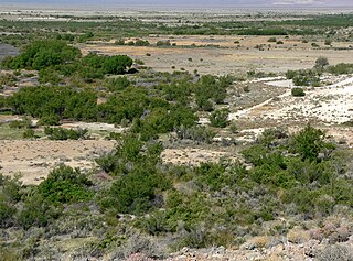
The Ash Meadows National Wildlife Refuge is a protected wildlife refuge located in the Amargosa Valley of southern Nye County, in southwestern Nevada. It is directly east of Death Valley National Park, and is 90 mi (140 km) west-northwest of Las Vegas.

The Moapa Valley National Wildlife Refuge (MVNWR) is a protected wildlife refuge administered by the U.S. Fish and Wildlife Service, located in the Warm Springs Natural Area in the Moapa Valley of Clark County, Nevada. The refuge is east of Death Valley and 60 miles (97 km) northeast of Las Vegas, Nevada.

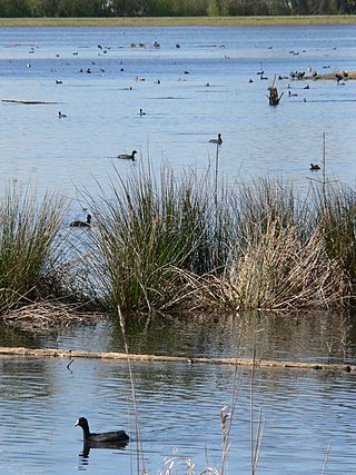
The Pahranagat National Wildlife Refuge is a protected wildlife refuge, at the southern end of the Pahranagat Valley and administered by the U.S. Fish and Wildlife Service. It is 90 miles (140 km) north of Las Vegas, Nevada, in Lincoln County, Nevada. The 5,380-acre (21.8 km2) refuge was created on August 16, 1963, and is part of the larger Desert National Wildlife Refuge Complex, which also includes the Ash Meadows National Wildlife Refuge, the Desert National Wildlife Refuge, and the Moapa Valley National Wildlife Refuge.

The National Bison Range Complex includes four National Wildlife Refuges and the Northwest Montana Wetland Management District, and is located in the northwestern region of Montana in the northwestern United States.

William L. Finley National Wildlife Refuge is a natural area in the Willamette Valley in Oregon, United States. It was created to provide wintering habitat for dusky Canada geese. Unlike other Canada geese, dusky Canada geese have limited summer and winter ranges. They nest on Alaska's Copper River Delta and winter almost exclusively in the Willamette Valley. Habitat loss, predation, and hunting have caused a decrease in population.
Ankeny National Wildlife Refuge is located in the fertile Willamette Valley of northwestern Oregon, 12 miles (19 km) south of Salem. The valley was once a rich mix of wildlife habitats. Valley wetlands were once extensive, with meandering stream channels and vast seasonal marshes. Today, the valley is a mix of farmland and growing cities, with few areas remaining for wildlife.

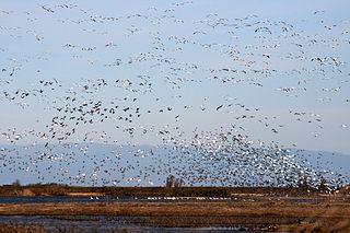
The Pacific Flyway is a major north-south flyway for migratory birds in the Americas, extending from Alaska to Patagonia. Every year, migratory birds travel some or all of this distance both in spring and in fall, following food sources, heading to breeding grounds, or travelling to overwintering sites.

Presquile National Wildlife Refuge in the U.S. state of Virginia is one of four refuges that make up the Eastern Virginia Rivers National Wildlife Refuge Complex. It is managed by the United States Fish and Wildlife Service. The refuge is a 1,329-acre (5.38 km2) island in the James River, located approximately 20 miles (32 km) south of Richmond. It is located in the easternmost part of Chesterfield County, northeast of Hopewell.

The James River National Wildlife Refuge is a National Wildlife Refuge located along the James River in eastern Prince George County, Virginia. Its management is overseen by the United States Fish and Wildlife Service.
The Eastern Virginia Rivers National Wildlife Refuge Complex is a complex of four National Wildlife Refuges in Virginia whose management is overseen by the United States Fish and Wildlife Service. The four refuges are:
The San Luis National Wildlife Refuge Complex is located in the northern San Joaquin Valley, within Merced County and Stanislaus County of California. The complex, with four federal National Wildlife Refuges, is managed by the U.S Fish & Wildlife Service.

The Middle Mississippi River National Wildlife Refuge is located on the Mississippi River downstream from St. Louis, Missouri. It is managed by the U.S. Fish and Wildlife Service as part of the Mark Twain National Wildlife Refuge Complex.

Silvio O. Conte National Fish and Wildlife Refuge was established in 1997 to conserve, protect and enhance the abundance and diversity of native plant, fish and wildlife species and the ecosystems on which they depend throughout the 7,200,000-acre (29,000 km2) Connecticut River watershed. The watershed covers large areas of Vermont, New Hampshire, Massachusetts and Connecticut. It contains a great diversity of habitats, notably: northern forest valuable as nesting habitat for migrant thrushes, warblers and other birds; rivers and streams used by shad, salmon, herring, the endangered shortnose sturgeon and other migratory fishes; and an internationally significant complex of high-quality tidal fresh, brackish and salt marshes.
Grasslands Wildlife Management Area lies within the San Joaquin River basin in California and supports the largest remaining block of wetlands in the Central Valley, containing 70,000 acres (280 km2) of private wetlands and associated, and surrounding 53,000 acres (210 km2) of state and federal lands. Perpetual conservation easements on private lands have been purchased by the United States Fish and Wildlife Service.

Butte Sink Wildlife Management Area is located in Colusa, Butte, and Sutter Counties. It is wetlands managed as part of the Sacramento National Wildlife Refuge Complex and is not open to the public.