False Cape Natural Area Preserve

Last updated
False Cape Natural Area Preserve
IUCN category V (protected landscape/seascape)

False Cape IMG 7523 (5857834580).jpg

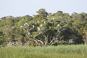
Egrets at False Cape Natural Area Preserve
USA Virginia location map.svg
Red pog.svg
Location Virginia Beach, Virginia
Coordinates 36°36′59″N75°53′43″W / 36.6163°N 75.8954°W / 36.6163; -75.8954 [1] Coordinates: 36°36′59″N75°53′43″W / 36.6163°N 75.8954°W / 36.6163; -75.8954 [1]
Area 3,573 acres (14.46 km2)
Established 2002 (2002)
Governing body Virginia Department of Conservation and Recreation

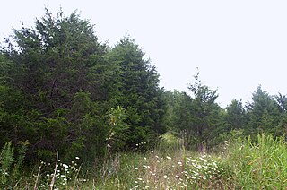
False Cape Natural Area Preserve is a 3,573-acre (14.46 km2) Natural Area Preserve located in Virginia Beach, Virginia, just north of the state border with North Carolina. The preserve covers a one-by-six-mile (1.6 by 9.7 km) strip of largely undeveloped land located on False Cape between the Atlantic Ocean and Back Bay, and is one of the most undisturbed areas of coastal habitat remaining in the Mid-Atlantic.

Virginia Natural Area Preserve System

The Virginia Natural Area Preserve System is a system of protected areas in the state of Virginia. It is managed by the Virginia Department of Conservation and Recreation.

Virginia Beach, Virginia Independent city in Virginia

Virginia Beach is an independent city located on the southeastern coast of the Commonwealth of Virginia in the United States. As of the 2010 census, the population was 437,994. In 2015, the population was estimated to be 452,745. In 2017 the estimated population was 450,435. Although mostly suburban in character, it is the most populous city in Virginia and the 41st most populous city in the nation. Located on the Atlantic Ocean at the mouth of the Chesapeake Bay, Virginia Beach is included in the Hampton Roads metropolitan area. This area, known as "America's First Region", also includes the independent cities of Chesapeake, Hampton, Newport News, Norfolk, Portsmouth, and Suffolk, as well as other smaller cities, counties, and towns of Hampton Roads.

North Carolina State of the United States of America

North Carolina is a state in the southeastern region of the United States. It borders South Carolina and Georgia to the south, Tennessee to the west, Virginia to the north, and the Atlantic Ocean to the east. North Carolina is the 28th-most extensive and the 9th-most populous of the U.S. states. The state is divided into 100 counties. The capital is Raleigh, which along with Durham and Chapel Hill is home to the largest research park in the United States. The most populous municipality is Charlotte, which is the second-largest banking center in the United States after New York City.

Contents

The preserve protects a variety of wetland and upland habitats, including maritime and swamp forest, interdunal wetlands, and Back Bay marshes. It also hosts various plants and animals rare in Virginia, more than two dozen in all; many of these are southern species at the northern limit of their range in far southern Virginia. Many birds also come to the area during the fall and spring migrations. [2]

Wetland A land area that is permanently or seasonally saturated with water

A wetland is a distinct ecosystem that is inundated by water, either permanently or seasonally, where oxygen-free processes prevail. The primary factor that distinguishes wetlands from other land forms or water bodies is the characteristic vegetation of aquatic plants, adapted to the unique hydric soil. Wetlands play a number of functions, including water purification, water storage, processing of carbon and other nutrients, stabilization of shorelines, and support of plants and animals. Wetlands are also considered the most biologically diverse of all ecosystems, serving as home to a wide range of plant and animal life. Whether any individual wetland performs these functions, and the degree to which it performs them, depends on characteristics of that wetland and the lands and waters near it. Methods for rapidly assessing these functions, wetland ecological health, and general wetland condition have been developed in many regions and have contributed to wetland conservation partly by raising public awareness of the functions and the ecosystem services some wetlands provide.

Swamp A forested wetland

A swamp is a wetland that is forested. Many swamps occur along large rivers where they are critically dependent upon natural water level fluctuations. Other swamps occur on the shores of large lakes. Some swamps have hammocks, or dry-land protrusions, covered by aquatic vegetation, or vegetation that tolerates periodic inundation or soil saturation. The two main types of swamp are "true" or swamp forests and "transitional" or shrub swamps. In the boreal regions of Canada, the word swamp is colloquially used for what is more correctly termed a bog, fen, or muskeg. The water of a swamp may be fresh water, brackish water or seawater. Some of the world's largest swamps are found along major rivers such as the Amazon, the Mississippi, and the Congo.

Marsh A wetland that is dominated by herbaceous rather than woody plant species

A marsh is a wetland that is dominated by herbaceous rather than woody plant species. Marshes can often be found at the edges of lakes and streams, where they form a transition between the aquatic and terrestrial ecosystems. They are often dominated by grasses, rushes or reeds. If woody plants are present they tend to be low-growing shrubs. This form of vegetation is what differentiates marshes from other types of wetland such as swamps, which are dominated by trees, and mires, which are wetlands that have accumulated deposits of acidic peat.

The preserve is owned and maintained by the Virginia Department of Conservation and Recreation as part of False Cape State Park, and comprises the undeveloped portions of the park; these were dedicated as a Natural Area Preserve in 2002. The preserve, like the remainder of False Cape State Park, is not publicly accessible by vehicle. The nearest parking is approximately five miles (8 km) from the preserve, which can be accessed by hiking, boating, or via a seasonal shuttle. Visitors must travel through Back Bay National Wildlife Refuge, which assesses a separate access fee. [2]

The Virginia Department of Conservation and Recreation is a department of the government of Virginia; it oversees all Virginia state parks and Natural Area Preserves.

False Cape State Park

False Cape State Park is a 4,321-acre (17.49 km2) state park located on the Currituck Banks Peninsula, a one-mile-wide (1.6 km) barrier spit between the Back Bay of the Currituck Sound and the Atlantic Ocean, within the city of Virginia Beach, adjacent to the state border with North Carolina, and just north of Mackay Island National Wildlife Refuge.

Back Bay National Wildlife Refuge Wildlife reserve in Virginia, US

Back Bay National Wildlife Refuge in southeastern Virginia is located in the independent city of Virginia Beach. Established in 1938 in an isolated portion of the former Princess Anne County, it is managed by the U.S. Fish & Wildlife Service. The administrative office is located on Sandbridge Road at Sigma between Lago Mar and Sandbridge Beach. The Visitor Contact Center is accessed via Sandpiper Road from the Sandbridge area of Virginia Beach, which is the southernmost area of development on the Atlantic Coast of Virginia.

See also

Related Research Articles

Singletary Lake State Park

Singletary Lake State Park is a North Carolina state park in Bladen County, North Carolina in the United States. Located near Elizabethtown, it covers 1,221-acre (4.94 km2), including Singletary Lake, one of the largest Carolina bays. Singletary Lake State Park is southeast of Elizabethtown on North Carolina Highway 53 in North Carolina's Coastal Plain region. It serves primarily as a group camp but is open on a limited basis for year-round recreation, including hiking, fishing and observing nature.

Amsterdam Beach State Park

Amsterdam Beach State Park is a 199-acre (0.81 km2) undeveloped state park on the Atlantic Ocean in the Town of East Hampton just east of Montauk, New York. The land is also known as the Amsterdam Beach Preserve.

Caledon State Park

Caledon State Park is a 2,579-acre (10.44 km2) state park located in King George, Virginia. The property was initially owned by the Alexander brothers, founders of the city of Alexandria, and was established in 1659 as Caledon Plantation. Ownership passed, in 1974, to the Commonwealth of Virginia.

Bethel Beach Natural Area Preserve

Bethel Beach Natural Area Preserve is a 105-acre (42 ha) Natural Area Preserve located in Mathews County, Virginia, near the Chesapeake Bay. It contains beach, low dune, and salt marsh habitats, and provides a haven for rare marsh and colonial nesting birds, The preserve also protects habitat for two globally rare species, the northeastern beach tiger beetle and sea-beach knotweed.

Cape Charles Coastal Habitat Natural Area Preserve

Cape Charles Coastal Habitat Natural Area Preserve is a 29-acre (12 ha) Natural Area Preserve located in Northampton County, Virginia on the Chesapeake Bay side of Virginia's Eastern Shore. The small preserve protects coastal beach, dune, and maritime forest habitat, preserving a home for the northeastern beach tiger beetle, listed as threatened in the United States. Coast bedstraw grows on the dunes. The preserve serves as a staging area for southward-bound migratory birds in the fall.

Chestnut Creek Wetlands Natural Area Preserve

Chestnut Creek Wetlands Natural Area Preserve is a 244-acre (99 ha) Natural Area Preserve located in Floyd County, Virginia. Local wetlands support several rare species, while the upland slopes support northern hardwoods including beech, birch, and maple. The area has a long farming and grazing history, but the wetlands have survived, dominated by sedges and grasses with few trees and shrubs. The property was acquired using a voter-approved state government bond and a recovery grant from the United States Fish and Wildlife Service.

Chotank Creek Natural Area Preserve

Chotank Creek Natural Area Preserve is a 1,108-acre (4.48 km2) Natural Area Preserve located in King George County, Virginia. The preserve is situated east of Caledon State Park, and borders the Potomac River to which the preserve's namesake, Chotank Creek, is tributary. It is part of the larger Cedar Grove farm, which is protected by a conservation easement. The preserve was dedicated in 2001 through an agreement with the property's private landowner.

Dameron Marsh Natural Area Preserve

Dameron Marsh Natural Area Preserve is a 316-acre (128 ha) Natural Area Preserve located in Northumberland County, Virginia. It is one in a series of protected areas lining the shores of the Chesapeake Bay, and contains one of the region's most significant wetlands for marsh-bird habitats. Its pristine beaches serve as a home for the northeastern beach tiger beetle. Some of the land had been used in the past for agriculture, however these former fields were restored to forest through the combined efforts of the Virginia Department of Conservation and Recreation, The Nature Conservancy, and the United States Army Corps of Engineers.

Folly Mills Creek Fen Natural Area Preserve

Folly Mills Creek Fen Natural Area Preserve is a Natural Area Preserve located in Augusta County, Virginia. The preserve was dedicated in 1998, and was the first privately owned Natural Area Preserve to be dedicated in the state.

Goshen Pass Natural Area Preserve

Goshen Pass Natural Area Preserve is a 936-acre (3.79 km2) Natural Area Preserve located in Rockbridge County, Virginia. The oldest state-managed natural area in Virginia, it was first acquired in 1954 to help protect views of the gorge along the Maury River. The site contains stands of chestnut oak, pine-oak-heath woodland, rocky scrub communities, regionally rare plants such as freshwater cordgrass, and habitat for the Appalachian jewelwing, a locally rare damselfly. The site was dedicated as a preserve in 2001.

Hughlett Point Natural Area Preserve

Hughlett Point Natural Area Preserve is a 204-acre (0.83 km2) Natural Area Preserve located in Northumberland County, Virginia. It preserves various types of habitat, including tidal and non-tidal wetlands, undeveloped beaches, dunes, and upland forests. Among the species living on the property is the northeastern beach tiger beetle, as well as other rare invertebrates. Hughlett Point is also an important staging area for various species of migrating bird.

Magothy Bay Natural Area Preserve

Magothy Bay Natural Area Preserve is a 286-acre (1.16 km2) Natural Area Preserve located in Northampton County, Virginia. The preserve encompasses woodlands, wetlands, and salt marshes, providing foraging areas for various species of waterfowl, shorebirds, and wading birds. Diamondback terrapins and clapper rails are frequent visitors, as are many varieties of songbird.

Marks and Jacks Island Natural Area Preserve

Mark's and Jack's Island Natural Area Preserve is a 2,000-acre (8.1 km2) Natural Area Preserve located in Accomack County, Virginia. The preserve supports Chesapeake Bay beach habitat, as well as various types of marsh, shrub, and forest vegetation. Many species of birds can be found in the preserve's wetlands, and numerous plant species live in the marsh, including marsh-elder. Loblolly pine and black cherry may be seen along the tops of some old dunes. The beaches provide a home for the northeastern beach tiger beetle.

Mutton Hunk Fen Natural Area Preserve

Mutton Hunk Fen Natural Area Preserve is a 516-acre (2.09 km2) Natural Area Preserve located in Accomack County, Virginia. Fronting on the Atlantic Ocean's Gargathy Bay to the east, it is also bounded by Whites Creek and Mutton Hunk Branch to its north. The property contains a rare "sea level fen" community, one of only four in Virginia. Despite the proximity to the ocean's saltwater, freshwater wetland plants are able to survive in this environment due to the influence of freshwater springs. Acidic conditions also encourage the growth of plants normally found in bogs, in addition to tidal freshwater wetland plants; five of the species found at the preserve are regionally rare.

Parkers Marsh Natural Area Preserve

Parkers Marsh Natural Area Preserve is a 759-acre (307 ha) Natural Area Preserve located in Accomack County, Virginia. The preserve incorporates beach habitat along the Chesapeake Bay as well as low marsh, high marsh, shrubland, and forest vegetation; the wetlands provide a home for many different species of animals and plants. About 75% of the site is saltmarsh. Marsh elder and black cherry may be found on old dune ridges on the site, as may loblolly pine. Some lower dunes support various grassland species. Peregrine falcons have nested in the area since 1998, and the rare saltmarsh sparrow has been observed nesting at the site. In addition, the beach provides a home for the northeastern beach tiger beetle, listed as threatened in the United States.

Parramore Island Natural Area Preserve

Parramore Island Natural Area Preserve is a 7,000-acre (28 km2) Natural Area Preserve located in Accomack County, Virginia, United States. Located on one of the barrier islands along the Atlantic Ocean, it is the state's largest Natural Area Preserve. More than 7.5 miles (12.1 km) long, it features a number of beaches, dunes, scrubs, marshes, and natural communities.

The Cedars Natural Area Preserve

The Cedars Natural Area Preserve is a Natural Area Preserve located in Lee County, Virginia. It protects rare plant and animal species adapted to the unique conditions of a karst landscape.

Princess Anne Wildlife Management Area

Princess Anne Wildlife Management Area is a 1,546-acre (6.26 km2) Wildlife Management Area (WMA) in Virginia Beach, Virginia. The area comprises four tracts; the Beasely, Trojan, and Whitehurst tracts are located on the western shore of Back Bay, separated from the Atlantic Ocean by False Cape, while the Pocahontas Tract, consisting of a number of marshy islands, is at the south end of the bay. A variety of natural communities may be found on all tracts, and water levels are manipulated to help promote the growth of food for waterfowl that migrate and overwinter in the area.

References

  1. 1 2 "False Cape". ProtectedPlanet. United Nations Environment Programme's World Conservation Monitoring Centre. Retrieved December 18, 2016.
  2. 1 2 "False Cape Natural Area Preserve". Virginia Department of Conservation and Recreation. Retrieved December 18, 2016.