Assateague Island National Seashore

Last updated
Assateague Island National Seashore
IUCN category V (protected landscape/seascape)
Assateague horses grazing.jpg
Feral horses graze in the dunes of Assateague Island National Seashore
USA Maryland relief location map.svg
Red pog.svg
USA Virginia relief location map.svg
Red pog.svg
Usa edcp relief location map.png
Red pog.svg
Location Worcester County, Maryland & Accomack County, Virginia, USA
Nearest city Ocean City, MD & Chincoteague, VA
Coordinates 38°05′00″N75°12′30″W / 38.08333°N 75.20833°W / 38.08333; -75.20833
Area41,320 acres (167.2 km2) [1]
AuthorizedJanuary 1, 1965 (1965-January-01)
Visitors2,340,269(in 2022) [2]
Governing body National Park Service
Website Assateague Island National Seashore

Assateague Island National Seashore is a unit of the National Park Service system of the U.S. Department of the Interior. Located on the East Coast along the Atlantic Ocean in Maryland and Virginia, Assateague Island is the largest natural barrier island ecosystem in the Middle Atlantic states region that remains predominantly unaffected by human development. Located within a three-hour drive to the east and south of Richmond, Washington, Baltimore, Wilmington, Philadelphia major metropolitan areas plus north of the several clustered smaller cities around Hampton Roads harbor of Virginia with Newport News, Hampton, Norfolk, Portsmouth, Chesapeake and Virginia Beach. The National Seashore offers a setting in which to experience a dynamic barrier island and to pursue a multitude of recreational opportunities. The stated mission of the park is to preserve and protect “unique coastal resources and the natural ecosystem conditions and processes upon which they depend, provide high-quality resource-based recreational opportunities compatible with resource protection and educate the public as to the values and significance of the area”.

Contents

Assateague Island encompasses a 37-mile-long barrier island, adjacent marsh islands and waters in Maryland and Virginia, and the Assateague Island Visitor Center on the Maryland mainland. 41,346 acres of land and water are within the seashore’s boundaries. The island consists of three public areas; Assateague Island National Seashore (managed by the National Park Service), Assateague State Park (managed by the Maryland Park Service of the Department of Natural Resources) and Chincoteague National Wildlife Refuge (managed by the U.S. Fish and Wildlife Service).

Geography

The park is located on a barrier island shaped by the stormy seas and gentle winds along the coast of the Delmarva Peninsula. The island is approximately 37 miles (60 km) long, yet never more than a mile wide. The park is divided into the Maryland District in the north and the Virginia District in the south. It is not possible to drive down the island from one district to the other. All automobile traffic must travel through the mainland to access one end of the island from the other.

The Maryland District of Assateague Island extends from the Ocean City Inlet to the Virginia state line. The Assateague Island National Seashore visitor center, campground, three nature trails, lifeguarded beach, and park headquarters and the smaller Assateague State Park sits within the borders of this district. The only access to the Maryland District is via the Verrazano Bridge on Maryland Route 611.

The Virginia District of Assateague Island extends from the Maryland state line south to the Chincoteague Inlet. This area of the island is designated as the Chincoteague National Wildlife Refuge and is managed by the US Fish and Wildlife Service (FWS). However, the National Park Service operates with a recreational beach, lifeguarded area and visitor center within a one-mile parking and visitor use section. This collaboration between the US Fish and Wildlife Service and the National Park Service is defined in an agreement or Memorandum of Understanding.The Chincoteague National Wildlife Refuge on the southern end of Assateague Island should not be confused with Chincoteague Island, the neighboring island to the west with a residential community on it. One must drive through Chincoteague Island in order to reach the Virginia District.

Geology and hydrology

Assateague Island is part of a chain of barrier islands that extend from Maine to Texas. The island is built from sand moving south via longshore drift building the island's length. The source of the sand is erosion and run-off from the Appalachian Mountains. The island is moving westward as a result of natural barrier processes during storms. [3] Water washes over the island, sending beach sand backward toward the bay. This barrier island “rollover” is accelerated as the climate changes and the sea level rises. This condition is most pronounced at the northern end of the island, where Ocean City's jetties have stabilized the islands north of the Ocean City Inlet and have starved Assateague of new sand. As a result, Assateague's beach is shifted several hundred meters westwards compared to Ocean City's. The inlet was formed during the 1933 Chesapeake–Potomac hurricane, separating Fenwick and Assateague islands, and a jetty was immediately constructed to stabilize the inlet. After severe nor'easters in 1998, a sand replenishment program was undertaken to restore a sand supply to the north end of Assateague and to ensure a continuing supply. [4]

History

Before the national seashore was created in 1965, the island was going to be turned into a private resort community called Ocean Beach, Maryland. Some 5,000 private lots comprising what is now NPS property were zoned and sold for resort development in the 1950s. However, the Ash Wednesday Storm of 1962 halted the plans for development. The nor'easter destroyed the few existing structures on the island that had been built and ripped the roads apart. Realizing that the island was too unstable to build upon, the housing development firm sold all of its land to the federal government. To this day, it is not possible to drive the entire length of the island; one must travel on the mainland to journey between the National Seashore in Maryland and the National Wildlife Refuge in Virginia.

Activities

Since the park's creation, several improvements have been made to aid the public in recreation. The park maintains a 2-mile (3 km) stretch of road on the island that travels through the state park in order for visitors to reach the National Seashore. A new visitor center was built in 2010 which is located on the mainland before visitors cross over the bridge to get to the island. The visitor center provides orientation information and exhibits for the public. Many ranger-led programs are available in the summer and fall. The park service also opened a new visitor contact station for campground operations, passes and permits on the island in 2012. The building is powered by new solar panels built in the nearby North Beach parking lot.

Camping

The park service maintains 148 campsites for both tents and recreational vehicles. On the Maryland side, campers have the option of an oceanside campsite on the west side of the main dune, or a bayside campsite on a peninsula projecting into Sinepuxent Bay. [5] While the oceanside campsites have quick access to the beach and ocean, the bayside campsites offer better views of the wetlands, often with horses grazing there throughout the day. The park also offers six backcountry camping sites, four located on the bayside which can be accessed by canoe, kayak, or hiking, and two hike-in oceanside sites. No fresh water is available at any of the backcountry sites. The bayside sites see high populations of biting insects in summer. No camping is available on the VA portion of the Island however there are several surrounding campgrounds in the town of Chincoteague and on the mainland. [6]

Except for the backcountry sites, reservations must be made for all campsites. Reservations can be made online or by calling 1-877-444-6777. Reservations are opened six months ahead of time and often book quickly, especially for weekends and holidays.

Hiking

The national seashore has three short nature trails, each of which are under a mile long.

The marsh trail is a half-mile trail on an elevated boardwalk over the marsh. Its elevation provides relief from mosquitoes and other bugs, and it provides excellent views of the salt marsh habitat.

The forest trail is also a half-mile long, consisting of easily walkable hard pack surface and boardwalk. Much of the trail is shaded by woodlands providing relief from the heat.

The dunes trail is three-quarters of a mile long, walked entirely in the sand. The trail offers a look at many of the different plants that can be found in this habitat, as well as a section of Baltimore Boulevard, a road that existed on the island before it was destroyed in the 1962 storm.

Swimming

While visitors can swim anywhere in the ocean, the National Park Service provides a lifeguarded beach in both MD and VA. During the summer, lifeguards are on duty between 10 a.m. and 5 p.m. The national seashore is also a popular destination for surfers, however, surfing is prohibited within the lifeguarded area.

Fishing

Saltwater fishing is a very popular activity at the national seashore. Anglers age 16 and older must possess a valid fishing license when fishing in Maryland or Virginia. Starting in 2011, all anglers must purchase a valid Maryland fishing license before going out.

Over-Sand Vehicle Zone

The over-sand vehicle (OSV) zone is designated for four-wheel drive vehicles to drive on the beach. The Maryland OSV zone extends from the main camping area in the park to the Virginia state line where the horse fence prevents access into the national refuge. A permit and a verified list of safety equipment is required for access to the OSV zone. [7] OSV access is limited to 145 vehicles at any time in Maryland, enforced by automatic gates, and 48 in Virginia, unless the Tom's Cove Hook is closed, in which case access is limited to 18 vehicles. OSV permits are issued for a year from the month of purchase. The permit fee ranges from $110 to $200, depending upon the type of access desired. All vehicles using the OSV zone must display a valid OSV Permit. Upon signing the registration for the OSV permit, operators accept responsibility for knowing and following all OSV regulations.

Ecology

The national seashore provides habitat for a variety of plants and animals adapted to the coastline environment. The coastal salt marsh environment attracts wading birds, seabirds and mammals, as well as animals that have adapted to the harsh environment.

Birds

Shorebirds and wading birds are abundant at Assateague. Breeding birds include piping plovers, great egrets and red-winged blackbirds. Seabirds include brown pelicans and several species of gulls and terns. Wooded habitats shelter ruby-crowned kinglets and white-eyed vireos. During the winter the area shelters northern birds, including brant geese and northern saw-whet owls. [8]

As a National Seashore, Assateague Island is required by federal law to protect species listed under the endangered species act. Piping Plovers, listed federally as a threatened species, fall under this category and are therefore protected on the island. During their summer breeding period, closures of the OSV zone and North end of the island often occur in order to prevent visitors from disturbing their nests or harming the newborn chicks.

Horses

Bands of feral horses, commonly known as Chincoteague ponies or as Assateague horses, freely roam on Assateague Island. Although local legend claims that the horses are descendants of animals that survived a shipwreck on the coast, it is more likely that the horses are descendants of domestic horses confined on the island by local residents in lieu of fencing them in on the mainland, where fences were taxed. The salty low-nutrient diet of saltmarsh grasses has resulted in the horses' short stature and bloated abdomens. [9]

Horses at Assateague Island National Seashore in August 2015

Two herds are kept separate by a fence at the Maryland-Virginia border. The horses in Virginia are owned by the Chincoteague Fire Department. These are the famous ponies that are herded every July and then swim to nearby Chincoteague Island as a fundraiser called "Pony Penning." In order to ensure healthy ponies to auction off, the firefighters provide them with food, water, and vet care. The Maryland herd is treated as wildlife and are not rounded up or removed from the island, [10] nor do they receive veterinary care. The National Park Service uses birth control to manage the herd size, injecting a vaccine known as PZP via a dart to control pregnancy and to keep the size of the herd within 80–100 horses. [9]

Though many of the horses on the island measure under 14 hands (4 ft 8 inches) in height, which would normally qualify them as ponies, most of their stock comes from horse breeds. Thus, despite their stunted height, which is attributed to their salty diet, they are considered horses and not ponies.

Though the horses, especially those in the developed area, may appear tame, they have been known to bite and kick park visitors. Visitors should be wary of the horses as they are feral animals and can cause serious harm to visitors who are too close to them. Additionally, rangers may write citations for visitors who are seen petting, feeding, or simply moving within 40 feet of the horses.

Fees and passes

Fees to enter Assateague Island National Seashore are charged per motor vehicle, and are reciprocal with passes from Chincoteague National Wildlife Refuge in Virginia. Additionally, all forms of Federal Recreational Lands passes, including golden age, military, and access passes are accepted as long as the passholder is present in the vehicle. A full fee schedule can be found online.

Related Research Articles

<span class="mw-page-title-main">Chincoteague, Virginia</span> Town in Virginia, United States

Chincoteague is a town in Accomack County, Virginia, U.S. The town includes the whole of Chincoteague Island and an area of adjacent water. The population was 2,941 at the 2010 census. The town is a tourist gateway to the Chincoteague National Wildlife Refuge on adjacent Assateague Island, the location of a popular recreational beach and home of the Virginia herd of Chincoteague Ponies. These ponies and the annual Pony Swim are the subject of Marguerite Henry's 1947 children's book Misty of Chincoteague, which was made into the 1961 family film Misty, filmed on location.

<span class="mw-page-title-main">Eastern Shore of Virginia</span> Region of Accomack and Northampton counties, Virginia, United States

The Eastern Shore of Virginia consists of two counties on the Atlantic coast detached from the mainland of the Commonwealth of Virginia in the United States. The 70-mile-long (110 km) region is part of the Delmarva Peninsula and is separated from the rest of Virginia by the Chesapeake Bay. Its population was 45,695 as of 2020.

Chincoteague may refer to:

<span class="mw-page-title-main">Assateague Island</span> Barrier island in Maryland and Virginia, United States

Assateague Island is a 37-mile (60 km) long barrier island located off the eastern coast of the Delmarva Peninsula facing the Atlantic Ocean. The northern two-thirds of the island is in Maryland, and the southern third is in Virginia.

<span class="mw-page-title-main">Gulf Islands National Seashore</span> 96,000 underwater acres in Mississippi and Florida (US) managed by the National Park Service

Gulf Islands National Seashore is an American national seashore that offers recreation opportunities and preserves natural and historic resources along the Gulf of Mexico barrier islands of Florida and Mississippi. In 2022, it was the eighth-most visited unit of the National Park Service.

<span class="mw-page-title-main">Assateague Light</span> Lighthouse in Virginia, United States

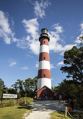
Assateague Light is the 142-foot-tall (43 m) lighthouse located on the southern end of Assateague Island off the coast of the Virginia Eastern Shore, United States. The lighthouse is located within the Chincoteague National Wildlife Refuge and can be accessed by road from Chincoteague Island over the Assateague Channel. It is owned by the U.S. Fish and Wildlife Service and operated by the U.S. Coast Guard and is still used as an active aid in navigation. The keeper's quarters are used as seasonal housing for refuge temporary employees, volunteers, and interns. Constructed in 1867 to replace a shorter lighthouse 45-foot-tall (14 m) built in 1833, the lighthouse is conical in shape and is painted in alternating bands of red and white.

<span class="mw-page-title-main">Back Bay National Wildlife Refuge</span> Wildlife reserve in Virginia, US

Back Bay National Wildlife Refuge in southeastern Virginia is located in the independent city of Virginia Beach. Established in 1938 in an isolated portion of the former Princess Anne County, it is managed by the U.S. Fish & Wildlife Service. The administrative office is located on Sandbridge Road at Sigma between Lago Mar and Sandbridge Beach. The Visitor Contact Center is accessed via Sandpiper Road from the Sandbridge area of Virginia Beach, which is the southernmost area of development on the Atlantic Coast of Virginia.

<i>Misty</i> (film) 1961 film by James B. Clark

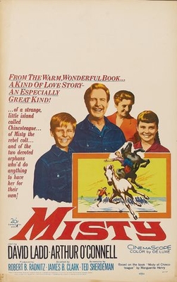
Misty is a 1961 American CinemaScope children's film based on Marguerite Henry's 1947 award-winning children's book Misty of Chincoteague.

<span class="mw-page-title-main">Outer Banks</span> Barrier islands in North Carolina, U.S.

The Outer Banks are a 200 mi (320 km) string of barrier islands and spits off the coast of North Carolina and southeastern Virginia, on the east coast of the United States. They line most of the North Carolina coastline, separating Currituck Sound, Albemarle Sound, and Pamlico Sound from the Atlantic Ocean. A major tourist destination, the Outer Banks are known for their wide expanse of open beachfront and the Cape Hatteras National Seashore. The seashore and surrounding ecosystem are important biodiversity zones, including beach grasses and shrubland that help maintain the form of the land.

<span class="mw-page-title-main">Chincoteague Pony</span> American horse breed

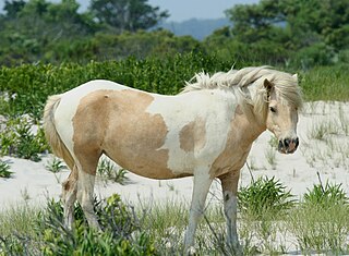
The Chincoteague pony, also known as the Assateague horse, is a breed of horse that developed, and now lives, within a semi-feral or feral population on Assateague Island in the US states of Virginia and Maryland. The Chincoteague pony is one of the many breeds of feral horses in the United States. The breed was made famous by the Misty of Chincoteague novels, written by pony book author Marguerite Henry, and first published in 1947, and the pony Misty of Chincoteague.

<span class="mw-page-title-main">Assateague State Park</span> State park in Maryland, United States

Assateague State Park is a public recreation area in Worcester County, Maryland, located at the north end of Assateague Island, a barrier island bordered by the Atlantic Ocean on the east and Sinepuxent Bay on the west. The state park is bordered on both its north and south sides by Assateague Island National Seashore and is reached via the Verrazano Bridge which carries Maryland Route 611 across Sinepuxent Bay. The park offers wildlife viewing, beach activities, and camping facilities. It is managed by the Maryland Park Service of the larger Maryland Department of Natural Resources with the support of volunteers working under the auspices of the non-profit Friends of Assateague State Park.

<span class="mw-page-title-main">Delaware Seashore State Park</span> State park in Delaware, United States

Delaware Seashore State Park is located near Dewey Beach, in Delaware, United States. It is bounded on the east by the Atlantic Ocean and on the west by Rehoboth Bay and Indian River Bay. The park covers 2,825 acres (1,143 ha). It is a major attraction for millions of visitors who come to the Delaware Beaches for water-related activities. Delaware Seashore State Park was created in 1965.

<span class="mw-page-title-main">Sinepuxent Bay</span> Bay in Worcester County, Maryland

Sinepuxent Bay is an inland waterway which connects Chincoteague Bay to Isle of Wight Bay, and is connected to the Atlantic Ocean via the Ocean City Inlet. It separates Sinepuxent Neck, in Worcester County, Maryland from Assateague Island, and West Ocean City, Maryland from downtown Ocean City. Islands in the Sinepuxent Bay include Horn Island and Skimmer Island. It is crossed by the Harry W. Kelley Memorial Bridge on U.S. Route 50 and the Verrazano Bridge on Maryland Route 611. The bay is the location of the islands that compose the Sinepuxent Bay Wildlife Management Area. Historically the area was referred to by various names including Sinepuxent, Sene Puxon, Synepuxent, Cinnepuxon, et al.

<span class="mw-page-title-main">Atlantic Flyway</span> Major north-south flyway for migratory birds in North America

The Atlantic Flyway is a major north-south flyway for migratory birds in North America. The route generally starts in Greenland, then follows the Atlantic coast of Canada, then south down the Atlantic Coast of the United States to the tropical areas of South America and the Caribbean. Every year, migratory birds travel up and down this route following food sources, heading to breeding grounds, or traveling to overwintering sites.

<span class="mw-page-title-main">Chincoteague Bay</span> Bay in Maryland Accomack County, Virginia

Chincoteague Bay is a lagoon between the Atlantic barrier islands of Assateague and Chincoteague and the mainland of Worcester County, Maryland and northern Accomack County, Virginia. At the bay's northern end, where it narrows between Assateague and Sinepuxent Neck, it becomes Sinepuxent Bay; Chincoteague Bay's southern end drains into the Atlantic Ocean via Queen Sound and Chincoteague Inlet. No major river flows into Chincoteague Bay—its largest tributaries are Newport Creek in Worcester County and Swans Gut Creek in Accomack County.

<span class="mw-page-title-main">Chincoteague National Wildlife Refuge</span> United States National Wildlife Refuge in Virginia

The Chincoteague National Wildlife Refuge is a 14,000-acre (57 km2) wildlife preserve operated by the U.S. Fish & Wildlife Service. It is primarily located on the Virginia half of Assateague Island with portions located on the Maryland side of the island, as well as Morris Island and Wildcat Marsh. Mostly composed of beach, dunes, marsh, and maritime forest, the refuge contains a large variety of wildlife animals and birds, including the Chincoteague Pony. The purpose of the refuge is to maintain, regulate and preserve animal and plant species as well as their habitats for present and future generations.

<span class="mw-page-title-main">Pony Penning</span> Annual pony swim and auction event in Virginia, USA

Pony Penning, sometimes known as Pony Penning Days or Pony Swim, is an annual event held in Chincoteague, Virginia on the last consecutive Wednesday and Thursday in July. The Chincoteague Fire Department conducts the event, which consists of a pony swim on Wednesday and a pony auction on Thursday. For the pony swim, the Saltwater Cowboys round up feral Chincoteague ponies from Assateague Island and drive them across the Assateague Channel to Veteran's Memorial Park on Chincoteague Island. The ponies swim across the channel during slack tide, when the water has minimal tidal movement. Once on Chincoteague Island, the Saltwater Cowboys herd the ponies to pens on the Chincoteague Carnival Grounds where some of the foals are auctioned off on Thursday.

<span class="mw-page-title-main">Watch Hill (New York)</span> Camground and marina on Fire Island, New York

Watch Hill is a campground and marina located on Fire Island, a barrier island off the south shore of New York's Long Island. The park is located across the Great South Bay from Patchogue and is contained within the Fire Island National Seashore.

<span class="mw-page-title-main">History of Chincoteague, Virginia</span>

The history of human activity in Chincoteague, on the Eastern Shore of Virginia, begins with the Native Americans. Until European explorers possessed the island in the late 17th century, the Chincoteague Indians used it as a place to gather shellfish, but are not known to have lived there; Chincoteague Island lacked suitable soil for their agriculture. The island's name derives from those early visitors: by one popular tale, chincoteague meant "Beautiful land across the water" in their language.

<span class="mw-page-title-main">Virginia Barrier Islands</span> Barrier islands along the coast of Virginia, United States

The Virginia Barrier Islands are a continuous chain of long, narrow, low-lying, sand and scrub barrier islands separated from one another by narrow inlets and from the mainland by a series of shallow marshy tidal bays along the entire coast of the Virginia end of the Delmarva Peninsula. Several of these islands were once significantly larger, covered with pine forests, and inhabited. After the completion of the New York, Philadelphia and Norfolk Railroad in the late 19th Century, at least five lavish hunting and fishing clubs were established on Virginia's barrier islands and they became a playground for wealthy sportsmen from Northeastern cities who would arrive by train. US President Grover Cleveland visited Hog Island to hunt waterfowl and go fishing in the early 1890s.

References

  1. "Listing of acreage – December 31, 2011" (XLSX). Land Resource Division, National Park Service. Retrieved 2012-03-19. (National Park Service Acreage Reports)
  2. "NPS Annual Recreation Visits Report". National Park Service. Retrieved 2023-07-23.
  3. "Coasts/Shorelines". Assateague Island National Seashore. National Park Service. Retrieved 17 January 2013.
  4. "Assateague Island National Seashore North End Restoration Project: Introduction" (PDF). National Park Service. Retrieved 17 January 2013.
  5. "Assateague Island National Seashore Campground Map" (PDF). Assateague Island National Seashore. National Park Service. Retrieved 18 January 2013.
  6. "Backcountry Camping". Assateague Island National Seashore. National Park Service. Retrieved 18 January 2013.
  7. "Over-Sand Vehicle (OSV) Use". Assateague Island National Seashore. National Park Service. Retrieved 18 January 2013.
  8. "Birds". Assateague Island National Seashore. National Park Service. Retrieved 22 January 2013.
  9. 1 2 "The Wild Horses of Assateague Island" (PDF). Assateague Island National Seashore. National Park Service. Retrieved 17 January 2013.
  10. "Assateague's Wild Horses". Assateague Island National Seashore. National Park Service. Retrieved 17 January 2013.