Padre Island National Seashore

Last updated
Padre Island National Seashore
IUCN category V (protected landscape/seascape)
Padre Island National Seashore, beach, Kleberg Co, TX; 1 Nov 2022.jpg
Relief map of Texas.png
Red pog.svg
Usa edcp relief location map.png
Red pog.svg
Location Padre Island, Texas, United States
Nearest city Corpus Christi, Texas
Coordinates 26°59′04″N97°22′50″W / 26.98444°N 97.38056°W / 26.98444; -97.38056
Area130,434 acres (527.85 km2)
EstablishedSeptember 28, 1962
Visitors650,000(in 2015)
Governing body National Park Service
Website Padre Island National Seashore
Map showing Padre Island National Seashore on Padre Island (center), south of Mustang Island. Map Padre Island towns.gif
Map showing Padre Island National Seashore on Padre Island (center), south of Mustang Island.

Padre Island National Seashore (PINS) is a national seashore located on Padre Island off the coast of South Texas. In contrast to South Padre Island, known for its beaches and vacationing college students, PINS is located on the north end of Padre Island and consists of a long beach where nature is preserved.

Contents

Most of the park is primitive, but camping is available, and most of the beach is only accessible to four-wheel-drive vehicles. All but four miles is open to vehicle traffic. PAIS is the fourth designated national seashore in the United States. [1]

Padre Island is the longest undeveloped barrier island in the world. The national seashore is 70 miles (110 km) long with 65.5 miles (105.4 km) of Gulf beach. PAIS hosts a variety of pristine beach, dune, and tidal flat environments, [2] including the Laguna Madre on its west coast, a famous spot for windsurfing. It is located in parts of Kleberg, Kenedy, and Willacy counties, with Kenedy County having the majority of its land area.

Padre Island

Padre Island National Seashore is located on Padre Island, the largest of the Texas barrier islands and the world's longest barrier island. The island is located along Texas's southern coast of the Gulf of Mexico and is noted for its white sandy beaches. Meaning father in Spanish, it was named after Father José Nicolás Ballí (c.1770-1829), who owned the island and served as a missionary priest and collector of finances for all the churches in the Rio Grande Valley. He also founded the first mission in present-day Cameron County. [3]

It is about 113 miles (182 km) long and 1.8 miles (3 km) wide, [4] Padre Island is the second-largest island by area in the contiguous United States, after Long Island in New York on the Atlantic Coast. [5]

Geology

The geology of Padre Island National Seashore doesn't just belong within the park itself. PAIS is part of the world's longest natural barrier bar system. Padre Island is a very young geological feature that only developed merely 4,500 to 5,000 years ago, according to radio carbon dating of shells. [6]

General physiography

Geologically extremely young, Padre Island is a vastly dynamic geologic feature. Unlike most of today's geologic features, such as the Grand Canyon or the likes, Padre Island changes constantly. Situated in a stable depository basin, there isn't much that can intervene with the barrier bars, except for the occasional hurricanes that come by. Most of Padre Island is less than 20 feet above mean sea level. Constant bombardment of prevailing southeasterly winds from the Gulf of Mexico heap beach of sand into high foredunes. In some places, the onshore wind may blow loose sand from the foredunes and beach across the flats beyond. Active sand dunes march across the island, smothering vegetation in their paths and leaving barren sandflats in their wakes. In other places, vegetation may win a battle of its own and stabilize the blowing sand by binding it with roots and vines. Slower daily movements of the sand and stabilizing effects of vegetation are interrupted occasionally by the brutal force of hurricane winds, waves, and tides. During storms, beaches are eroded, vegetation is ripped up, dunes are flattened, and channels are scoured across the island. [7]

Laguna Madre

Laguna Madre, separating Padre Island from the Texas mainland, is locked in by the barrier island. Consequently, circulation of seawater in and out of the lagoon is highly restricted. The combination of a high rate of evaporation under the hot Texas sun and little mixing with either freshwater or normal seawater has made Laguna Madre extremely salty.

The maximum width of the lagoon is approximately 10 miles. In many places, however, lagoon width fluctuates considerably with the height of wind-generated tides. The lagoon is widest during highest wind tides, which produce maximum flooding of the vast tidal flats.

Like the island environments, the environments of Laguna Madre vary considerably. Within the national seashore, the northern part of the lagoon is occupied largely by grassflats having an average water depth of about 3 feet. These grassflats are environments of very high biologic activity, serving as spawning grounds for a number of fish, clams, and snails.

The shallowest parts of the lagoon lie in the central part of the national seashore. These areas are known as Middle Ground and the Land-Cut Area, where the Intracoastal Waterway was dredged through the rarely flooded wind-tidal flats (pl. I). The Hole, which lies between Middle Ground and the Land-Cut Area, is not really much of a hole; its average depths are only 1 to 2 feet. This "hole" is occupied mostly by flats supporting shoalgrass and algae. The deepest parts of the lagoon are south of the Land-Cut Area, where the muddy sand bottoms lie at depths as great as 8 feet.

Two small natural islands in Laguna Madre are unique environments within the national seashore. North and South Bird Islands, each a series of sand berms or ridges, have become important bird rookeries. Some of the man-made spoil islands along the Intracoastal Waterway are also nesting grounds for a variety of birds.

Biology

Kemp's ridley sea turtles

A Kemp's ridley sea turtle laying eggs on PINS (10 May 2010) 2010 Kemp's ridley sea turtle project at Padre Island National Seashore (for NRC) (f1b41723-09a4-4933-8312-14fedb1c1b81).jpg
A Kemp's ridley sea turtle laying eggs on PINS (10 May 2010)

A program to re-establish a nesting beach for Kemp's ridley sea turtles on Padre Island was begun in 1978. In 1992, the first two turtles from the program returned to Padre Island beach to lay their eggs. The number of Kemp's ridley sea turtle nests on Padre Island has increased ever since with 28 being found in 2005. Park rangers at PAIS are involved in an effort to help this endangered species. In the summer, visitors can witness the release of newborn turtles.

In September 2007, Corpus Christi, Texas wildlife officials found a record of 128 Kemp's ridley sea turtle nests on Texas beaches, including 81 on North Padre Island (Padre Island National Seashore) and 4 on Mustang Island. Wildlife officials released 10,594 Kemp's ridleys hatchlings along the Texas coast this year. The turtles are endangered due to shrimpers' nets and they are popular in Mexico as boot material and food. [8]

Birdwatching

Due to the location of Padre Island National Seashore on the Central Flyway, a major migratory route for birds, about 380 species of birds have been documented within the park, which represents approximately 45% of all bird species documented within North America. The park was designated as a "Globally Important Bird Area" by the American Bird Conservancy in 1998 for providing an "important habitat for globally significant numbers of Brown Pelicans, Redheads (5% of the world's population), Least Terns (8% of the North American population), Piping Plovers (10% of the world's population), Reddish Egrets (7% of the biogeographic population) and Peregrine Falcons (7% of the North American population)." [9] [10]

The best time to see the multitude of the park's bird migrants is during either early spring or fall and winter, when thousands of birds spend the winter there or migrate through the area. [11] During the summer the most common birds are shore and marshbirds as well as some raptors and songbirds. The most common birds on the Gulf beach of the park during the year are the willet, sanderling, black skimmer, great blue heron, double-crested cormorant, cattle egret, grey plover, laughing gull, brown pelican, reddish egret, and five species of terns, including the least tern, Caspian tern, black tern, Sandwich tern, and royal tern. The two periodically appearing birds nesting on the park's shores are the least tern and piping plover. [10]

Bird Island Basin, on the Laguna Madre side of the park, may be periodically dry during the summer or during periods of extended drought. It is home to a wide variety of birds when wet, including black-necked stilts, roseate spoonbills, great egrets, American white ibis, and many others. [10]


Shoreline trash

A bottle lies tangled with seaweed and fishing line in Padre Island National Seashore Trash on Padre Island.jpg
A bottle lies tangled with seaweed and fishing line in Padre Island National Seashore

During periods throughout the summer months there may be a large amount of Sargassum , a brown seaweed, which washes up on the shore which aids in shore development by acting to hold sand in place, which can eventually build up the shoreline. Currents within the Gulf of Mexico are responsible for the transport of this seaweed mainly from the Sargasso Sea, but have also been responsible for the transport of trash to the shores of the park. This trash can be anything that is tossed overboard into the Gulf of Mexico as well as items that are either washed into the Gulf from land, or from the interior of the country by means of sewers that empty into the Gulf. These items can range from tiny pieces of plastic, hypodermic needles, and lumber, to nets or bleach bottles tossed overboard by shrimpers and even objects as large as buoys and steel containers. An international treaty known as MARPOL is designed to limit the dumping of wastes into the Gulf [12] but there can be violators and the enforcement of the treaty is difficult, as well as the fact that some trash can originate from sewage transport or even come from the Equator. [13] Oil and tar can commonly wash up onto the beaches as well, 94% of which originates from oil spills, engine lubrication oil, and tanker washings. The park relies on a "grass roots" policy that encourages park visitors to take out more trash than they bring in. Organization such as the Friends of Padre have removed over 2,000 tons of trash at their yearly Billy Sandifer Big Shell Beach Clean Up the last weekend of February every year.

A study by the park, started in 1994, to analyze the origin of debris, titled the PAIS Marine Debris Point Source Investigation. The park began collecting data in 1998 to catalogue and remove debris from 16 miles (26 km) of beach. Currently the park has collected over 1,000 days of data for the project, covering a collective area of over 16,800 miles (27,000 km) of shoreline surveyed. This study is one of the first long-term and comprehensive marine debris research projects started within the United States. From its result the vast majority of the debris is traced to the commercial shrimping industry while approximately 14% comes from the offshore oil and gas industry. [14]

Naturalist and fishing guide Billy Sandifer founded an annual beach cleanup at the park in 1996. The cleanup targets the Big Shell Beach portion of the island, around the 20-25 mile marker. In 2007, Sandifer established the Friends of Padre, a non-profit association to fund park projects and to organize the cleanup. [1] [15]

Climate

Keeled Earless Lizard (Holbrookia propinqua) male, Padre Island NS (Nov 2022) Holbrookia propinqua, male, Padre Island National Seashore, Kleberg Co. TX; 2 Nov 2022.jpg
Keeled Earless Lizard ( Holbrookia propinqua ) male, Padre Island NS (Nov 2022)
A Spanish Dagger (Yucca treculeana) growing in the grassland of Padre Island National Seashore (26 November 2011) Padre Island National Seashore, Kleberg County, Texas, USA (26 November 2011).jpg
A Spanish Dagger ( Yucca treculeana ) growing in the grassland of Padre Island National Seashore (26 November 2011)
Padre Island National Seashore
Climate chart (explanation)
J
F
M
A
M
J
J
A
S
O
N
D
 
 
35
 
 
17
12
 
 
62
 
 
20
14
 
 
35
 
 
23
17
 
 
44
 
 
25
18
 
 
62
 
 
30
22
 
 
40
 
 
34
24
 
 
42
 
 
34
24
 
 
45
 
 
39
26
 
 
215
 
 
30
24
 
 
43
 
 
29
22
 
 
99
 
 
23
20
 
 
50
 
 
21
17
Average max. and min. temperatures in °C
Precipitation totals in mm
Source: [16]
Imperial conversion
JFMAMJJASOND
 
 
1.4
 
 
63
54
 
 
2.4
 
 
68
57
 
 
1.4
 
 
73
63
 
 
1.7
 
 
77
64
 
 
2.4
 
 
86
72
 
 
1.6
 
 
93
75
 
 
1.7
 
 
93
75
 
 
1.8
 
 
102
79
 
 
8.5
 
 
86
75
 
 
1.7
 
 
84
72
 
 
3.9
 
 
73
68
 
 
2
 
 
70
63
Average max. and min. temperatures in °F
Precipitation totals in inches

Oil and natural gas drilling

Oil and natural gas drilling is allowed within the park. Congress has not approved the purchase of the mineral rights within the park even though the boundaries were surveyed as early as 1957. [17] This has caused some controversy because the land is a protected seascape under IUCAN. Heavy equipment is used within the park and is transported across beaches that are nesting areas for not only sea turtles but many birds, including the piping plover, least tern, and other animals that may nest within the park.

Related Research Articles

<span class="mw-page-title-main">Barrier island</span> Coastal dune landform that forms by wave and tidal action parallel to the mainland coast

Barrier islands are a coastal landform, a type of dune system and sand island, where an area of sand has been formed by wave and tidal action parallel to the mainland coast. They usually occur in chains, consisting of anything from a few islands to more than a dozen. They are subject to change during storms and other action, but absorb energy and protect the coastlines and create areas of protected waters where wetlands may flourish. A barrier chain may extend for hundreds of kilometers, with islands periodically separated by tidal inlets. The largest barrier island in the world is Padre Island of Texas, United States, at 113 miles (182 km) long. Sometimes an important inlet may close permanently, transforming an island into a peninsula, thus creating a barrier peninsula, often including a beach, barrier beach. Though many are long and narrow, the length and width of barriers and overall morphology of barrier coasts are related to parameters including tidal range, wave energy, sediment supply, sea-level trends, and basement controls. The amount of vegetation on the barrier has a large impact on the height and evolution of the island.

<span class="mw-page-title-main">Perdido Key State Park</span> State park in Florida, United States

Perdido Key State Park is a 247-acre (1.00 km2) Florida State Park located on a barrier island fifteen miles (24 km) southwest of Pensacola, off S.R. 292, in northwestern Florida. The address is 12301 Gulf Beach Highway.

<span class="mw-page-title-main">Assateague Island</span> Barrier island in Maryland and Virginia, United States

Assateague Island is a 37-mile (60 km) long barrier island located off the eastern coast of the Delmarva Peninsula facing the Atlantic Ocean. The northern two-thirds of the island is in Maryland, and the southern third is in Virginia.

<span class="mw-page-title-main">Laguna de Términos</span> Lagoon on the Gulf coast of Mexico

Laguna de Términos is the largest tidal lagoon by volume located entirely on the Gulf of Mexico, as well as one of the most biodiverse. Exchanging water with several rivers and lagoons, the Laguna is part of the most important hydrographic river basin in Mexico. It is important commercially, as well as ecologically by serving as a refuge for extensive flora and fauna; its mangroves play an important role as a refuge for migratory birds.

<span class="mw-page-title-main">Gulf Islands National Seashore</span> 96,000 underwater acres in Mississippi and Florida (US) managed by the National Park Service

Gulf Islands National Seashore is an American National seashore that offers recreation opportunities and preserves natural and historic resources along the Gulf of Mexico barrier islands of Florida and Mississippi. In 2023, it was the fifth-most visited unit of the National Park Service.

<span class="mw-page-title-main">Padre Island</span> Barrier island in southern Texas

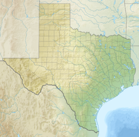
Padre Island is the largest of the Texas barrier islands and the world's longest barrier island. The island is located along Texas's southern coast of the Gulf of Mexico and is noted for its white sandy beaches. Meaning father in Spanish, it was named after Father José Nicolás Ballí (c.1770-1829), who owned the island and served as a missionary priest and collector of finances for all the churches in the Rio Grande Valley. He also founded the first mission in present-day Cameron County.

<span class="mw-page-title-main">Horn Island (Mississippi)</span>

Horn Island is a long, thin barrier island off the Gulf Coast of Mississippi, south of Ocean Springs. It is one of the Mississippi–Alabama barrier islands and part of the Gulf Islands National Seashore. Horn Island is several miles long, but less than a mile wide at its widest point. It occupies about 4.2 square miles (11 km2).

<span class="mw-page-title-main">Assateague Island National Seashore</span> Barrier island operated by the National Park Service of the United States

Assateague Island National Seashore is a unit of the National Park Service system of the U.S. Department of the Interior. Located on the East Coast along the Atlantic Ocean in Maryland and Virginia, Assateague Island is the largest natural barrier island ecosystem in the Middle Atlantic states region that remains predominantly unaffected by human development. Located within a three-hour drive to the east and south of Richmond, Washington, Baltimore, Wilmington, Philadelphia major metropolitan areas plus north of the several clustered smaller cities around Hampton Roads harbor of Virginia with Newport News, Hampton, Norfolk, Portsmouth, Chesapeake and Virginia Beach. The National Seashore offers a setting in which to experience a dynamic barrier island and to pursue a multitude of recreational opportunities. The stated mission of the park is to preserve and protect “unique coastal resources and the natural ecosystem conditions and processes upon which they depend, provide high-quality resource-based recreational opportunities compatible with resource protection and educate the public as to the values and significance of the area”.

<span class="mw-page-title-main">Western Gulf coastal grasslands</span> Subtropical grassland ecoregion of Mexico and the United States

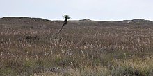
The Western Gulf coastal grasslands are a subtropical grassland ecoregion of the southern United States and northeastern Mexico. It is known in Louisiana as the "Cajun Prairie", Texas as "Coastal Prairie," and as the Tamaulipan pastizal in Mexico.

<span class="mw-page-title-main">Perdido Key, Florida</span> Unincorporated community in Florida, United States

Perdido Key is an unincorporated community in Escambia County, Florida located between Pensacola, Florida and Orange Beach, Alabama. The community is located on and named for Perdido Key, a barrier island in northwest Florida and southeast Alabama. "Perdido" means "lost" in the Spanish and Portuguese languages. The Florida district of the Gulf Islands National Seashore includes the east end of the island, as well as other Florida islands. No more than a few hundred yards wide in most places, Perdido Key stretches some 16 miles (26 km) from near Pensacola to Perdido Pass Bridge near Orange Beach.

<span class="mw-page-title-main">Mustang Island</span> Texas barrier island

Mustang Island is a barrier island on the Gulf Coast of Texas in the United States. The island is 18 miles (29 km) long, stretching from Corpus Christi to Port Aransas. The island is oriented generally northeast–southwest, with the Gulf of Mexico on the east and south, and Corpus Christi Bay on the north and west. The island's southern end connects by roadway to Padre Island. At the northern end of the island is Port Aransas, beyond which is San José Island. The Aransas Channel, also known as the "Aransas Pass," which separates Mustang Island from San José Island, is protected by jetties extending into the Gulf from each island.

<span class="mw-page-title-main">Canaveral National Seashore</span> National Seashore in the state of Florida, U.S.

The Canaveral National Seashore (CANA) is a National Seashore located between New Smyrna Beach and Titusville, Florida, in Volusia and Brevard Counties. The park, located on a barrier island, was created on January 3, 1975, by an act of Congress. The park is split between Brevard and Volusia counties, with 9 miles of the seashore in Brevard County, and 15 miles of the seashore in Volusia County. CANA consists of 24 miles of beaches, dunes, mangrove wetlands, and a large portion of the Mosquito Lagoon. The Canaveral National Seashore is also the longest expanse of undeveloped land along the East Coast of Florida. The Canaveral National Seashore is home to more than 1,000 plant species and 310 bird species. CANA occupies 57,662 acres (23,335 ha). There are 3 major beach sections in the seashore. The southern section is Playalinda Beach, the middle section is Klondike Beach, and the northern section is Apollo Beach.

<span class="mw-page-title-main">Pea Island National Wildlife Refuge</span> National Wildlife Refuge in North Carolina, United States

Pea Island National Wildlife Refuge is a national wildlife refuge located on North Carolina's Pea Island, a coastal barrier island and part of a chain of islands known as the Outer Banks, adjacent to Cape Hatteras National Seashore. The sanctuary is located 10 miles (16 km) south of Nags Head, North Carolina on NC 12.

<span class="mw-page-title-main">North Padre Island</span>

North Padre Island is a barrier island along the coast of Texas. It and South Padre Island were formed after the creation of the Port Mansfield Channel split Padre Island in two. From north to south, North Padre Island is located in parts of Nueces, Kleberg, Kenedy, and Willacy counties. The northernmost part of the island to the Kleberg County line is part of the city of Corpus Christi. Padre Island was once one island —today it is two and referred as North Padre Island, and South Padre Island. Padre Island National Seashore welcomed 674,704 visitors in 2020. Padre Island National Seashore is a national park that includes about 66 miles of undeveloped beaches and natural habitat. The national seashore is located on [North] Padre Island near the city of Corpus Christi, Texas. This national park is open 24 hours a day and seven days a week for visitors.

<span class="mw-page-title-main">Laguna Madre (United States)</span> Hypersaline lagoon in Texas, US

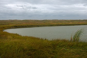
The Laguna Madre is a long, shallow, hypersaline lagoon along the western coast of the Gulf of Mexico in Nueces, Kenedy, Kleberg, Willacy and Cameron Counties in Texas, United States. It is one of seven major estuaries along the Gulf Coast of Texas. The roughly 20-mile (32 km) long Saltillo Flats land bridge divides it into Upper and Lower lagoons joined by the Intracoastal Waterway, which has been dredged through the lagoon. Cumulatively, Laguna Madre is approximately 130 miles (210 km) long, the length of Padre Island in the US. The main extensions include Baffin Bay in Upper Laguna Madre, Red Fish Bay just below the Saltillo Flats, and South Bay near the Mexican border. As a natural ecological unit, the Laguna Madre of the United States is the northern half of the ecosystem as a whole, which extends into Tamaulipas, Mexico approximately 144 miles (232 km) south of the US border, to the vicinity of the Rio Soto La Marina and the town of La Pesca, extending approximately 275 miles (443 km) through USA and Mexico in total.

<span class="mw-page-title-main">Estuaries of Texas</span> Estuaries on the Gulf coast of Texas

The U.S. state of Texas has a series of estuaries along its coast on the Gulf of Mexico, most of them bounded by the Texas barrier islands. Estuaries are coastal bodies of water in which freshwater from rivers mixes with saltwater from the sea. Twenty-one drainage basins terminate along the Texas coastline, forming a chain of seven major and five minor estuaries: listed from southwest to northeast, these are the Rio Grande Estuary, Laguna Madre, the Nueces Estuary, the Mission–Aransas Estuary, the Guadalupe Estuary, the Colorado–Lavaca Estuary, East Matagorda Bay, the San Bernard River and Cedar Lakes Estuary, the Brazos River Estuary, Christmas Bay, the Trinity–San Jacinto Estuary, and the Sabine–Neches Estuary. Each estuary is named for its one or two chief contributing rivers, excepting Laguna Madre, East Matagorda Bay, and Christmas Bay, which have no major river sources. The estuaries are also sometimes referred to by the names of their respective primary or central water bodies, though each also includes smaller secondary bays, inlets, or other marginal water bodies.

<span class="mw-page-title-main">Mississippi–Alabama barrier islands</span> Islands in the Gulf of Mexico

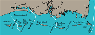
The Mississippi–Alabama barrier islands are a chain of barrier islands in the Gulf of Mexico along the coasts of Mississippi and Alabama enclosing the Mississippi Sound. The major islands are Cat Island, Ship Island, Horn Island, Petit Bois Island, and Dauphin Island; in the early 20th century the chain also included the Isle of Caprice, which has since been submerged. The islands are separated by wide inlets, several of which have been channelized to form the shipping channels for Gulf coast ports. The shapes and sizes of the islands have changed significantly since the 1800s, with the islands generally shrinking and shifting westward, especially after major tropical cyclones. Most of the islands are uninhabited. Much of the Mississippi portion of the chain is included in the Gulf Islands National Seashore.

<span class="mw-page-title-main">Port Mansfield Channel</span> Artificial water inlet in Texas, United States

Port Mansfield Channel or Mansfield Cut is an artificial waterway encompassing the Laguna Madre positioned at the 97th meridian west on the earth's longest barrier island known as Padre Island. During Post–World War II, the tidal inlet was dredged as a private channel differentiating North Padre Island better known as Padre Island National Seashore and South Padre Island. The navigable waterway was channeled during the late 1950s ceremoniously cresting the intertidal zone of the Gulf of Mexico by September 1957 on the Texas Gulf Coast.

<span class="mw-page-title-main">Sea Turtle, Inc.</span> Sea turtle rescue organization

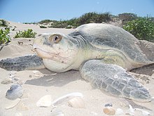
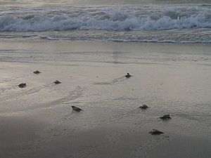
Sea Turtle, Inc. is a nonprofit sea turtle rescue and rehabilitation center in South Padre Island, Texas. It is a popular regional ecotourism center, seeing about a quarter million visitors per year. Its mission is to rescue, rehabilitate, and release sick and injured sea turtles; to educate the public about sea turtles and marine conservation; and to help conserve all sea turtle species, particularly those native to the Gulf of Mexico.

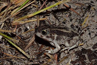
Perdido Key is a 24 kilometres (15 mi) long barrier island on the north coast of the Gulf of Mexico. The island extends from Pensacola Pass on the east to Perdido Pass on the west. Most of the island is in Florida, with the western end of the island in Alabama. Santa Rosa Island is to the east of the island, and Alabama Point is to the west. Perdido Key was attached to the mainland until the 1940s when a canal separated it from the mainland. The eastern part of the island forms part of the Gulf Islands National Seashore, which includes the Perdido Key Historic District, the site of three shore batteries that once defended Pensacola Bay. The rest of the island, with the exception of the Perdido Key State Park, has been developed as a resort and residential community. As a barrier island, Perdidio Key is subject to changes due to wave action and longshore currents, particularly from hurricanes. The endangered Perdido Key beach mouse is endemic to the island.

References

  1. 1 2 David Sikes of Corpus Christi Caller-Times , "Padre Island seashore marks 50th", Laredo Morning Times , December 3, 2012, p. 3A
  2. "Geological Wonders". National Park Service website. Archived from the original on 2006-10-05. Retrieved 2006-06-25.
  3. "Ballí, José Nicolás". Handbook of Texas Online. Texas State Historical Society. Retrieved 2015-08-15.
  4. Garrison, J. R.; Williams, J.; Potter Miller, S.; Weber, E. T.; McMechan, G.; Zeng, X. (2010). "Ground-Penetrating Radar Study of North Padre Island: Implications for Barrier Island Internal Architecture, Model for Growth of Progradational Microtidal Barrier Islands, and Gulf of Mexico Sea-Level Cyclicity". Journal of Sedimentary Research. 80 (4): 303–319. Bibcode:2010JSedR..80..303G. doi:10.2110/jsr.2010.034.
  5. "Texas Bureau of Economic Geology: Padre Island National Seashore: A Guide to the Geology, Natural Environments, and History of a Texas Barrier Island (Origin and Geologic History of Padre Island)". Archived from the original on 2007-08-30.
  6. "Texas Bureau of Economic Geology: Padre Island National Seashore: A Guide to the Geology, Natural Environments, and History of a Texas Barrier Island (Introduction)". Archived from the original on 2007-09-03.
  7. Yahoo.com, Endangered turtle nests found in Texas
  8. Padre Island Administrative History, Addendum: Events Since 1994 Archived 2006-10-14 at the Wayback Machine , National Park Service, Retrieved February 1, 2015
  9. 1 2 3 "Birdwatching". Padre Island National Seashore. National Park Service. Retrieved 2009-09-01.
  10. "Padre Island National Seashore birds". National Park Service. Retrieved 2019-07-25.
  11. "International Convention for the Prevention of Pollution from Ships, 1973, as modified by the Protocol of 1978 relating thereto (MARPOL)". Archived from the original on 2008-07-30. Retrieved 2008-07-30.
  12. Handbook of Texas Online – GULF OF MEXICO
  13. Padre Island National Seashore - Shoreline Trash (U.S. National Park Service)
  14. "Friends of Padre". Friends of Padre Inc. Retrieved 2023-03-15.
  15. "NASA Earth Observations Data Set Index". NASA. Retrieved 30 January 2016.
  16. "The Oil and Gas Story - Padre Island National Seashore (U.S. National Park Service)".