
Denison is a city in Grayson County, Texas, United States, 1 mile (1.6 km) south of the Texas–Oklahoma border. Its population was 24,479 at the 2020 and 22,682 at the 2010 censuses. Denison is part of the Texoma region and is one of two principal cities in the Sherman–Denison metropolitan statistical area. Denison is the birthplace of U.S. President Dwight D. Eisenhower.

Brazos Bend State Park is a 4,897-acre (1,982 ha) state park along the Brazos River in unincorporated Fort Bend County, Texas, run by the Texas Parks and Wildlife Department. The park is open year-round, with the exception of several weekends a year during which it is closed for controlled hunts to manage the white-tailed deer population.

Inks Lake State Park is a state park located in Burnet County, Texas, United States, next to Inks Lake on the Colorado River. The landscape of the park is hilly, with many cedar, live oak, prickly pear cacti, and yuccas. The ground is rocky, mainly consisting of gneiss rock.

Cooper Lake State Park is a Texas State Park in Delta and Hopkins counties, about three miles (5 km) south of Cooper, Texas. The park is situated on Jim Chapman Lake, formerly known as Cooper Lake. There are actually two geographically separate units; the Doctors Creek unit 33°20′54″N95°40′08″W is located on the north side of the lake, in Delta County, while the South Sulphur unit 33°17′49″N95°39′35″W is located on the south side of the lake, in Hopkins County.
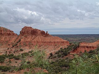
Caprock Canyons State Park and Trailway is a Texas state park located along the eastern edge of the Llano Estacado in Briscoe County, Texas, United States, approximately 100 miles (160 km) southeast of Amarillo. The state park opened in 1982 and is 15,314 acres (6,197 ha) in size, making it the third-largest state park in Texas.
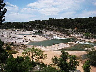
Pedernales Falls State Park is a 5,212-acre state park situated along the banks of the Pedernales River in Blanco County, Texas in the United States.

The Texas Parks & Wildlife Department (TPWD) is a Texas state agency that oversees and protects wildlife and their habitats. In addition, the agency is responsible for managing the state's parks and historical areas. Its mission is to manage and conserve the natural and cultural resources of Texas and to provide hunting, fishing, and outdoor recreation opportunities for the use and enjoyment of present and future generations.

Cedar Hill State Park is located on FM 1382 and the eastern shore of Joe Pool Lake in Cedar Hill, Texas (USA), ten miles southwest of Dallas. The park was acquired in 1982 and was opened in 1991. The Texas Parks and Wildlife Department operates the 1,826-acre (739 ha) park.

Buescher State Park is a state park located just north of Smithville, Texas. The park consists of 1,016.7 acres (411 ha) of public land donated to the state by Mr. Emil and Mrs. Elizabeth Buescher, as well as the City of Smithville.
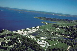
Eisenhower State Park is a state park located in Grayson County, Texas, northwest of Denison, Texas on the shores of Lake Texoma. The park is 423.1 acres (171 ha).
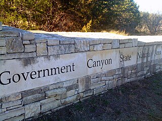
First opened to the public in October, 2005, Government Canyon State Natural Area (GCSNA) preserves 12,244 acres of rugged hills and canyons typical of the Texas Hill Country. It is designated a Natural Area, rather than a State Park, and therefore the primary focus is maintenance and protection of the property's natural state. Accordingly, access and recreational activities may be restricted if the Texas Parks & Wildlife Department (TPWD) deems such action necessary to protect the environment.

Kickapoo Cavern State Park is a state park straddling the Kinney and Edwards county line in Texas, located 22 miles north of Brackettville. The park is 6,368 acres (2,577 ha).

South Llano River State Park is a 2600 acre state park located along the South Llano River in Kimble County, Texas. The park opened to the public in 1990 and is managed by the Texas Parks and Wildlife Department.

Fort Boggy State Park is a 1,847 acres (747 ha) state park located in Leon County, Texas between Leona and Centerville. The park was donated to the Texas Parks and Wildlife Department in 1985 by Eileen Crain Sullivan to be developed as a state park. The park features swimming, hiking, mountain biking, canoeing, kayaking and fishing.

Meridian State Park is a state park in Bosque County, Texas, United States. The park is 505 acres (204 ha).

Lake Cypress Springs is a 3,461-acre (1,401 ha) reservoir in northeast Texas, approximately 90 miles (140 km) east of Dallas, Texas. The lake is used for recreational, municipal, and industrial purposes. The lake is regularly monitored by a lake patrol, which enforces wake zones, fishing licenses, boat dock rules, and boating. Lake Cypress Springs has 20 subdivisions and around 850 waterfront homes. In 2011, Lake Cypress Springs was rated one of "The 10 Best Lakes to Call Home" according to D Magazine.
Lake Athens is a 1,799 acre reservoir located to the east of Athens, Texas in Henderson County.
Martin Creek Lake State Park is a 286 acres (116 ha) developed recreational area in East Texas in the United States. The park is located southwest of Tatum on Martin Creek Lake in Rusk County and is managed by the Texas Parks and Wildlife Department. The Texas Utilities Generating Company deeded the park to the state in 1976, and it opened the same year.
Lake Whitney State Park is a state park located in Hill County, Texas, near Whitney, Texas. The park is 775 acres (314 ha).
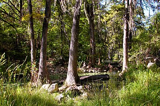
Honey Creek State Natural Area is a nature preserve of almost 2300 acres in western Comal County, Texas, United States. The Texas Parks and Wildlife Department acquired part of the natural area from the Nature Conservancy in 1985 and the rest from a private individual in 1988. Honey Creek opened in 1985 with access by guided tour only. Since Honey Creek is designated a "Natural Area" rather than a "State Park", the Texas Parks and Wildlife Department's first priority is the maintenance and preservation of the property's natural state.


