
Presidio County is a county located in the U.S. state of Texas. As of the 2020 census, its population was 6,131. Its county seat is Marfa. The county was created in 1850 and later organized in 1875. Presidio County is in the Trans-Pecos region of West Texas and is named for the border settlement of Presidio del Norte. It is on the Rio Grande, which forms the Mexican border.

Presidio is a city in Presidio County, Texas, United States. It is situated on the Rio Grande River, on the opposite side of the U.S.–Mexico border from Ojinaga, Chihuahua. The name originates from Spanish and means "fortress". The population was 3,264 at the 2020 census.

Hueco Tanks is an area of low mountains and historic site in El Paso County, Texas, in the United States. It is located in a high-altitude desert basin between the Franklin Mountains to the west and the Hueco Mountains to the east. Hueco is a Spanish word meaning hollows and refers to the many water-holding depressions in the boulders and rock faces throughout the region. Due to the unique concentration of historic artifacts, plants and wildlife, the site is under protection of Texas law; it is a crime to remove, alter, or destroy them.

El Presidio Real de Santa Bárbara, also known as the Royal Presidio of Santa Barbara, is a former military installation in Santa Barbara, California, United States. The presidio was built by Spain in 1782, with the mission of defending the Second Military District in California. In modern times, the Presidio serves as a significant tourist attraction, museum and an active archaeological site as part of El Presidio de Santa Barbara State Historic Park.

The Texas Parks & Wildlife Department (TPWD) is a Texas state agency that oversees and protects wildlife and their habitats. In addition, the agency is responsible for managing the state's parks and historical areas. Its mission is to manage and conserve the natural and cultural resources of Texas and to provide hunting, fishing, and outdoor recreation opportunities for the use and enjoyment of present and future generations.
Fort Richardson was a United States Army installation located in present-day Jacksboro, Texas. Named in honor of Union General Israel B. Richardson, who died in the Battle of Antietam during the American Civil War, it was active from 1867 to 1878. Today, the site, with a few surviving buildings, is called Fort Richardson State Park, Historic Site and Lost Creek Reservoir State Trailway. It was designated a National Historic Landmark in 1963 for its role in securing the state's northern frontier in the post-Civil War era.

Magoffin Home is located in El Paso, Texas. It was placed on the National Register of Historic Places in 1971. The surrounding area was declared the Magoffin Historic District on February 19, 1985. The home is now known as the Magoffin Home State Historic Site under the authority of the Texas Historical Commission.

Farm to Market Road 170 is a 114.6-mile (184.4 km) highway maintained by the Texas Department of Transportation (TxDOT) in Presidio and Brewster counties in Texas. The route, known locally as the River Road, runs along the United States side of the Rio Grande which in Texas forms the international boundary between the U.S. and Mexico. The road runs from Candelaria through the city of Presidio as well as several smaller communities and former settlements to State Highway 118 in Study Butte near Big Bend National Park. The road also passes through the southern portion of Big Bend Ranch State Park.

Shafter is a ghost town in Presidio County, Texas, United States. The Texas Attorney General's Office listed a population of 11 as of the 2000 Census. It was named in honor of General William R. Shafter, who at one point commanded the nearby Fort Davis. As of 2012, at least one silver mine, La Mina Grande, had been reopened by Aurcana Corporation.

Big Bend Ranch State Park is a 311,000-acre (126,000 ha) state park located on the Rio Grande in Brewster and Presidio counties, Texas. It is the largest state park in Texas. The closest major town is Presidio, Texas. The state park's head office is located in Lajitas, Texas at the Barton Warnock Visitor Center. It includes Colorado Canyon.
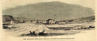
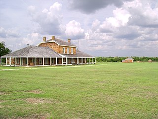
Fort Lancaster is a former United States Army installation located near Sheffield, Texas. The fort was established in 1855 on the San Antonio–El Paso Road to protect migrants moving toward California through Texas. The US Army occupied Fort Lancaster until Texas seceded from the United States in March 1861 and were replaced at the fort by forces loyal to the Confederate States of America. The Confederate Army held the fort from November 1861 until April 1862, when it was again abandoned and then burned.

The Landmark Inn State Historic Site is a historic inn in Castroville, Texas, United States. It serves the general public as both a state historic site and a bed & breakfast with eight overnight rooms.
Milton Faver was a pioneering cattle rancher in Presidio County, Texas, the preeminent cattle baron of the Big Bend in the nineteenth century, and one of the most important individual contributors to Big Bend history. Also known in his time by the honorary title, don Melitón, he founded Cibolo Creek Ranch halfway between Marfa and Presidio, Texas in 1857. He was one of the earliest Texas trail drivers, driving his cattle to market in New Orleans in the 1850s and to other markets later. Although his birthplace is not known with certainty, he was most likely born and raised in Missouri around 1822. Local lore contends that, while in his teens, he fought a duel and fled south, believing he had killed his opponent.

Mission Nuestra Señora del Espíritu Santo de Zúñiga, also known as Aranama Mission or Mission La Bahía, was a Roman Catholic mission established by Spain in 1722 in the Viceroyalty of New Spain—to convert native Karankawa Indians to Christianity. Together with its nearby military fortress, Presidio La Bahía, the mission upheld Spanish territorial claims in the New World against encroachment from France. The third and final location near Goliad, Texas is maintained now as part of Goliad State Park and Historic Site

Lake Bob Sandlin State Park is a state park in Titus County, Texas managed by the Texas Parks and Wildlife Department. The park covers 639.8 acres of land on the northern shore Lake Bob Sandlin about 10 miles southwest of Mount Pleasant.

Seminole Canyon State Park and Historic Site is a state park in the U.S. state of Texas. It is located off U.S. Route 90, east of the Pecos River High Bridge, 9 miles (14 km) west of Comstock in Val Verde County. The park is conducive to camping, biking, bird watching, back packing and archeological study. Cave art and archeological artifacts date back to the earliest human habitation in the area. The park is part of the larger Seminole Canyon Archeological District on the National Register of Historic Places.

The Zaragoza Birthplace State Historic Park is located adjacent to Presidio La Bahía in Goliad State Park and Historic Site, Goliad County in the U.S. state of Texas. An amphitheater and bronze statue of Ignacio Zaragoza are also on the grounds.

Bentsen-Rio Grande Valley State Park is located at 2800 S. Bentsen Palm Drive south of the city of Mission in Hidalgo County in the U.S. state of Texas. It serves as the headquarters for the World Birding Center.

Devil's Sinkhole State Natural Area is a natural bat habitat near the city of Rocksprings in Edwards County in the U.S. state of Texas. Carved by water erosion, the cavern is home to several million Mexican free-tailed bats that emerge at sunset during April through October.

Cibolo Creek Ranch is a historic place in Presidio County, Texas, United States. Established as a cattle ranch prior to the Civil War, it has been used in modern times for hunting and a shooting location for the movie industry. It includes a fort called El Fortin del Cibolo which has been renovated as a luxury hotel featuring watchtowers and three-foot-thick adobe walls.


