Grulla National Wildlife Refuge

Last updated
Grulla National Wildlife Refuge
Grulla Salt Lake 2009.jpg
Flat playa surface of Arch Lake
Grulla Topo Quad.jpg
Location Roosevelt County, New Mexico / Bailey County, Texas, United States
Coordinates 34°05′43″N103°04′00″W / 34.09528°N 103.06667°W / 34.09528; -103.06667 Coordinates: 34°05′43″N103°04′00″W / 34.09528°N 103.06667°W / 34.09528; -103.06667
Area13.1 km2 (5.1 sq mi)
Elevation1,177 m (3,862 ft)
Established1969
OperatorU.S. Fish and Wildlife Service
Website Grulla NWR

Grulla National Wildlife Refuge is located primarily in eastern New Mexico in Roosevelt County, southwest of the intersection of State Highway 88 and the Texas - New Mexico border about 25 miles southeast of Portales, New Mexico and southeast of the tiny community of Arch. A very small part of the refuge extends eastward into western Bailey County, Texas. [1]

New Mexico State of the United States of America

New Mexico is a state in the Southwestern region of the United States of America; its capital and cultural center is Santa Fe, which was founded in 1610 as capital of Nuevo México, while its largest city is Albuquerque with its accompanying metropolitan area. It is one of the Mountain States and shares the Four Corners region with Utah, Colorado, and Arizona; its other neighboring states are Oklahoma to the northeast, Texas to the east-southeast, and the Mexican states of Chihuahua to the south and Sonora to the southwest. With a population around two million, New Mexico is the 36th state by population. With a total area of 121,592 sq mi (314,920 km2), it is the fifth-largest and sixth-least densely populated of the 50 states. Due to their geographic locations, northern and eastern New Mexico exhibit a colder, alpine climate, while western and southern New Mexico exhibit a warmer, arid climate.

Roosevelt County, New Mexico County in the United States

Roosevelt County is a county located in the U.S. state of New Mexico. As of the 2010 census, the population was 19,846. Its county seat is Portales. The county was created in 1903 from Chaves and Guadalupe counties and named for President Theodore Roosevelt. The county's eastern border is the Texas state line.

Texas State of the United States of America

Texas is the second largest state in the United States by both area and population. Geographically located in the South Central region of the country, Texas shares borders with the U.S. states of Louisiana to the east, Arkansas to the northeast, Oklahoma to the north, New Mexico to the west, and the Mexican states of Chihuahua, Coahuila, Nuevo León, and Tamaulipas to the southwest, and has a coastline with the Gulf of Mexico to the southeast.

Contents

The central focal point of the Grulla National Wildlife Refuge is an ephemeral salt lake or saline playa – a shallow basin that collects runoff from the surrounding drainage area during heavy downpours but then often dries completely due to evaporation. This playa lake has been known by various names. Current USGS topographic maps and most commercially available maps of this region refer to this saline playa simply as "Salt Lake". [2] [3] Back in the early 1880s, this playa was part of the DZ Ranch, and those familiar with the ranch often favor the name "DZ Lake". The lake is also frequently called "Arch Lake" after the nearby community of Arch, New Mexico, located around 6 km to the northwest. [4] [5]

Salt lake landlocked body of water which has a high concentration salts

A salt lake or saline lake is a landlocked body of water that has a concentration of salts and other dissolved minerals significantly higher than most lakes. In some cases, salt lakes have a higher concentration of salt than sea water; such lakes can also be termed hypersaline lakes. An alkalic salt lake that has a high content of carbonate is sometimes termed a soda lake.

United States Geological Survey Scientific agency of the United States government

The United States Geological Survey is a scientific agency of the United States government. The scientists of the USGS study the landscape of the United States, its natural resources, and the natural hazards that threaten it. The organization has four major science disciplines, concerning biology, geography, geology, and hydrology. The USGS is a fact-finding research organization with no regulatory responsibility.

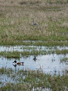
The word grulla is Spanish for crane. When wet, the playa lake provides habitat to sandhill cranes and the grasslands within the refuge provide habitat to other birds such as ring-necked pheasants, lesser prairie chickens, and scaled quails. [6]

Spanish language Romance language

Spanish or Castilian, is a Romance language that originated in the Iberian Peninsula and today has hundreds of millions of native speakers in Spain and the Americas. It is a global language and the world's second-most spoken native language, after Mandarin Chinese.

Sandhill crane species of bird

The sandhill crane is a species of large crane of North America and extreme northeastern Siberia. The common name of this bird refers to habitat like that at the Platte River, on the edge of Nebraska's Sandhills on the American Plains. This is the most important stopover area for the nominotypical subspecies, the lesser sandhill crane, with up to 450,000 of these birds migrating through annually.

Lesser prairie chicken species in the grouse family

The lesser prairie chicken is a species in the grouse family. It is a medium to large bird, striped white and brown, slightly smaller and paler than its near relative the greater prairie chicken. Adults range from 15.0-16.1 in (38-41 cm) in length and 22.1-28.7 oz in weight.

The refuge has no facilities other than a parking lot and trails and is administered by Muleshoe National Wildlife Refuge in Texas. It was often used in the mid 2000s as a training site for the Eastern New Mexico University cross country teams.

Muleshoe National Wildlife Refuge

Muleshoe National Wildlife Refuge is a 6,440-acre (26.1 km2) wildlife refuge located about twenty miles (32 km) south of Muleshoe, Texas on Texas State Highway 214. It is the oldest National Wildlife Refuge in the U.S. state of Texas, having been established as the Muleshoe Migratory Waterfowl Refuge by executive order of President Franklin D. Roosevelt in 1935. Roosevelt issued a proclamation in 1940 changing the name to the Muleshoe National Wildlife Refuge. In 1980, Muleshoe National Wildlife Refuge was designated as a National Natural Landmark by the National Park Service.
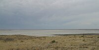
See also

Blackwater Draw Dry stream channel in New Mexico, US

Blackwater Draw is an intermittent stream channel about 140 km (87 mi) long, with headwaters in Roosevelt County, New Mexico, about 18 km (11 mi) southwest of Clovis, New Mexico, and flows southeastward across the Llano Estacado toward the city of Lubbock, Texas, where it joins Yellow House Draw to form Yellow House Canyon at the head of the North Fork Double Mountain Fork Brazos River. It stretches across eastern Roosevelt County, New Mexico, and Bailey, Lamb, Hale, and Lubbock Counties of West Texas and drains an area of 1,560 sq mi (4,040 km2).

Llano Estacado Southwestern United States in New Mexico and Texas

Llano Estacado, often translated as Staked Plains, is a region in the Southwestern United States that encompasses parts of eastern New Mexico and northwestern Texas. One of the largest mesas or tablelands on the North American continent, the elevation rises from 3,000 feet (900 m) in the southeast to over 5,000 feet (1,500 m) in the northwest, sloping almost uniformly at about 10 feet per mile (1.9 m/km).

Eastern New Mexico Region in New Mexico, United States

Eastern New Mexico is a physiographic subregion within the U.S. state of New Mexico. The region is sometimes called the "High Plains," "Eastern Plains ," or even "Little Texas". The region is largely coterminous with the portion of the Llano Estacado in New Mexico. Eastern New Mexico mostly lies upon the high plains, which extends to elevations over 4,000 ft (1,200 m). The region is mostly characterized by flat featureless terrain with the exception of the Pecos River valley and the abrupt breaks along the Mescalero Ridge and northern caprock escarpments of the Llano Estacado. The region typically lacks the high relief of central and northern New Mexico, such as that in the Sangre de Cristo and Sandia mountain ranges.

Related Research Articles

Muleshoe, Texas City in Texas, United States

Muleshoe is a city in Bailey County, Texas, United States. The town of Muleshoe was founded in 1913 when the Pecos and Northern Texas Railway built an 88-mile (142 km) line from Farwell, Texas, to Lubbock through northern Bailey County. In 1926, Muleshoe was incorporated. The population was 5,158 at the 2010 census. The county seat of Bailey County, it is home to the National Mule Memorial.

Morton, Texas City in Texas, United States

Morton is a city and county seat of Cochran County, Texas, United States. As of the 2010 census, the city population was 2,006. This represented a 10.8% population decline since the 2000 Census.

Bitter Lake National Wildlife Refuge Protected wetland area in Chavez County, New Mexico.

Bitter Lake National Wildlife Refuge is a United States National Wildlife Refuge located in two separate sections in central Chaves County, New Mexico, United States, a few miles northeast of the city of Roswell. Both sections lie on the banks of the Pecos River. The refuge was established in 1937 to provide habitat for migratory birds such as the sandhill crane and the snow goose, but it is also notable for rare native fish and the over 90 species of dragonflies and damselflies that inhabit the refuge.

Ridgefield National Wildlife Refuge American wildlife preserve

Ridgefield National Wildlife Refuge is a wildlife preserve, one of the national wildlife refuges operated by the United States Fish and Wildlife Service, located in the westernmost part of Clark County, Washington. The refuge protects more than 5,200 acres (2,100 ha) of marshes, grasslands, and woodlands. The refuge was established in 1965, in response to a need to establish vital winter habitat for wintering waterfowl with an emphasis on the dusky Canada goose whose nesting areas in Alaska were severely impacted by the violent earthquake of 1964.

Bowdoin National Wildlife Refuge

Bowdoin National Wildlife Refuge is a 15,551-acre (6,293 ha) National Wildlife Refuge (NWR) located in the north-central region of the U.S. state of Montana. The refuge is 7 mi (11 km) northeast of Malta, Montana in the Milk River Valley and is managed by the U.S. Fish and Wildlife Service.

Lost Trail National Wildlife Refuge

Lost Trail National Wildlife Refuge is a 8,834-acre (3,575 ha) National Wildlife Refuge of the United States located in Montana. Established in 1999, it is one of the newest National Wildlife Refuges in the U.S. and is managed by the U.S. Fish and Wildlife Service, an agency of the U.S. Department of the Interior. The refuge was originally a sprawling horse and cattle ranch dating back to the late 19th century and was known as the Lost Trail Ranch. The refuge consists of prairie and wetlands, and has a wide diversity of plant and animal species, including over 100 species of birds such as canada geese, sandhill crane, wood duck, green-winged teals and herons. Several species of grouse also inhabit the refuge. Predatory bird species such as the great horned owl and red-tailed hawk are also found here.

Lake Ilo National Wildlife Refuge

Lake Ilo National Wildlife Refuge (NWR) is located in the U.S. state of North Dakota and is managed from Audubon National Wildlife Refuge by the U.S. Fish and Wildlife Service. The refuge consists of Lake Ilo, surrounding wetlands and some upland range, providing habitat for hundreds of species of birds, and numerous fish and mammal species. An average of over 16 inches (40 cm) of precipitation falls annually, supporting a prairie ecosystem.

Grays Lake is a wetland in Idaho, United States. It lies in Bonneville County and Caribou County. Grays Lake National Wildlife Refuge was established in the area in 1965. Ranching is the predominant use of surrounding lands.

Glacial Ridge National Wildlife Refuge

Glacial Ridge National Wildlife Refuge was created on October 12, 2004, the 545th National Wildlife Refuge in the United States. Its creation was the result of cooperation between at least 30 agencies or governmental entities. The creation of the refuge was spearheaded by The Nature Conservancy, and the initial endowment of 2,300 acres (9.3 km2) of land was donated by the Conservancy. In light of its planned final size of 37,756 acres (153 km2), it is described by the US Fish and Wildlife Service as "the largest tallgrass prairie and wetland restoration project in U.S. history."

Brazoria National Wildlife Refuge

The Brazoria National Wildlife Refuge is a 44,414-acre (179.74 km2) wildlife conservation area along the coast of Texas (USA), east of the towns of Angleton and Lake Jackson, Texas. It borders a bay on the Intracoastal Waterway, behind a barrier island at the Gulf of Mexico.

Monahans Sandhills State Park Monahans, Texas

The Monahans Sandhills State Park is a 3,840-acre (1,550 ha) state park located in the southern Llano Estacado in Ward County and Winkler County, Texas. The closest major town is Monahans, Texas, and the closest limited-access highway ingress is Exit 86 on Interstate 20.

Sonny Bono Salton Sea National Wildlife Refuge

The Sonny Bono Salton Sea National Wildlife Refuge is located 40 miles (64 km) north of the Mexican border at the southern end of the Salton Sea in California's Imperial Valley. Situated along the Pacific Flyway, the Refuge is the only one of its kind, located 227 feet (69 m) below sea level. Because of its southern latitude, elevation and location in the Colorado Desert, the Refuge experiences some of the highest temperatures in the nation. Daily temperatures from May to October generally exceed 100 °F with temperatures of 116°–120 °F recorded yearly.

Buffalo Lake National Wildlife Refuge

Buffalo Lake National Wildlife Refuge is a protected area in Randall County in the Texas Panhandle. Its shortgrass prairies spill into marshes, woodlands, riparian habitat, croplands, and water-carved canyon walls that together form 7,664 acres (31.02 km2) of homes for migratory and year-round wildlife. The area forms a habitat for black-tailed prairie dogs and burrowing owls, among many other species. Some 175 acres (0.71 km2) of the refuge carries the designation of National Natural Landmark.

Washita National Wildlife Refuge

Washita National Wildlife Refuge is a National Wildlife Refuge (NWR) of the United States located in Custer County, Oklahoma. Created in 1961 on the shore of Foss Lake, it was the fourth NWR in the state. It is 5 miles (8.0 km) west of Butler, Oklahoma.

Needmore, Bailey County, Texas Unincorporated community in Texas, United States

Needmore is an unincorporated community in Bailey County, Texas, United States.

Bula, Texas Unincorporated community in Texas, United States

Bula is an unincorporated community in Bailey County, Texas, United States.

Needmore, Terry County, Texas Unincorporated community in Texas, United States

Needmore is a small unincorporated community in north central Terry County, Texas, United States.

References

  1. USFWS. "Grulla National Wildlife Refuge". U.S. Fish & Wildlife Service. Retrieved 29 September 2010.
  2. USGS. 1985. Golden Ranch Quadrangle. 7.5 minute series, United States Department of the Interior, U.S. Geological Survey, 1 map.
  3. Burdett, W.H. 1998. The Roads of New Mexico. Shearer Publishing, Austin: Hart Graphics, 128 pp.
  4. Wendorf, F. 1961. Paleoecology of the Llano Estacado. Museum of New Mexico Press, 144 pp.
  5. Reeves, C.C. 1968. Introduction to Paleolimnology. Elsevier, 228 pp.
  6. USGS. "Grulla National Wildlife Refuge". Bird Checklists of the United States. Retrieved 29 October 2009.