Potter County is a county located in the U.S. state of Texas. As of the 2020 census, its population was 118,525. Its county seat is Amarillo. The county was created in 1876 and organized in 1887. It is named for Robert Potter, a politician, signer of the Texas Declaration of Independence, and the Texas Secretary of the Navy.

Hutchinson County is a county in the U.S. state of Texas. As of the 2020 census, its population was 20,617. Its county seat is Stinnett. The county was created in 1876, but not organized until 1901. It is named for Andrew Hutchinson, an early Texas attorney.

Fritch is a city in Hutchinson and Moore Counties in the U.S. state of Texas. The population was 2,117 at the 2010 census. The mayor is Dwight Kirksey.

Montezuma Castle National Monument protects a set of well-preserved dwellings located in Camp Verde, Arizona, which were built and used by the Sinagua people, a pre-Columbian culture closely related to the Hohokam and other indigenous peoples of the southwestern United States, between approximately AD 1100 and 1425. The main structure comprises five stories and about 20 rooms and was built over the course of three centuries.

Dinosaur National Monument is an American national monument located on the southeast flank of the Uinta Mountains on the border between Colorado and Utah at the confluence of the Green and Yampa rivers. Although most of the monument area is in Moffat County, Colorado, the Dinosaur Quarry is located in Utah, north of the town of Jensen, Utah. The nearest Colorado town is Dinosaur while the nearest city is Vernal, Utah.

Agate Fossil Beds National Monument is a U.S. National Monument near Harrison, Nebraska. The main features of the monument are a valley of the Niobrara River and the fossils found on Carnegie Hill and University Hill.

The Aztec Ruins National Monument in northwestern New Mexico, USA, consists of preserved structures constructed by the Pueblo Indians. The national monument lies on the western bank of the Animas River in Aztec, New Mexico, about 12 miles (19 km) northeast of Farmington. Additional Puebloan structures can be found in Salmon Ruins and Heritage Park, about 9.5 miles (15.3 km) south. Archaeological evidence puts the construction of the ruins in the 12th and 13th centuries. The Puebloan-built ruins were dubbed the "Aztec Ruins" by 19th century American settlers who misattributed their construction to the Aztecs.

The George Washington Birthplace National Monument is a national monument in Westmoreland County, Virginia, at the confluence of Popes Creek and the Potomac River. It commemorates the birthplace location of George Washington, a Founding Father and the first President of the United States, who was born here on February 22, 1732. Washington lived at the residence until age three and later returned to live there as a teenager.
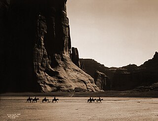
Canyon de Chelly National Monument was established on April 1, 1931, as a unit of the National Park Service. Located in northeastern Arizona, it is within the boundaries of the Navajo Nation and lies in the Four Corners region. Reflecting one of the longest continuously inhabited landscapes of North America, it preserves ruins of the indigenous tribes that lived in the area, from the Ancestral Puebloans to the Navajo. The monument covers 83,840 acres and encompasses the floors and rims of the three major canyons: de Chelly, del Muerto, and Monument. These canyons were cut by streams with headwaters in the Chuska Mountains just to the east of the monument. None of the land is federally owned. Canyon de Chelly is one of the most visited national monuments in the United States.

Fort Frederica National Monument, on St. Simons Island, Georgia, preserves the archaeological remnants of a fort and town built by James Oglethorpe between 1736 and 1748 to protect the southern boundary of the British colony of Georgia from Spanish raids. About 630 British troops were stationed at the fort.

Walnut Canyon National Monument is a United States National Monument located about 10 mi (16 km) southeast of downtown Flagstaff, Arizona, near Interstate 40. The canyon rim elevation is 6,690 ft (2,040 m); the canyon's floor is 350 ft lower. A 0.9 mi (1.4 km) long loop trail descends 185 ft (56 m) into the canyon passing 25 cliff dwelling rooms constructed by the Sinagua, a pre-Columbian cultural group that lived in Walnut Canyon from about 1100 to 1250 AD. Other contemporary habitations of the Sinagua people are preserved in the nearby Tuzigoot and Montezuma Castle national monuments.
Chickasaw National Recreation Area is a national recreation area in the foothills of the Arbuckle Mountains in south-central Oklahoma near Sulphur in Murray County. It includes the former Platt National Park and Arbuckle Recreation Area.
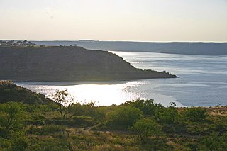
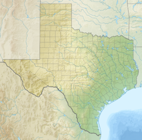
Lake Meredith National Recreation Area is a United States national recreation area located about 30 miles (48 km) north of Amarillo, Texas, in the Texas Panhandle. Its main attraction is 10,000-acre (4,000 ha) Lake Meredith, a reservoir created by Sanford Dam on the Canadian River.
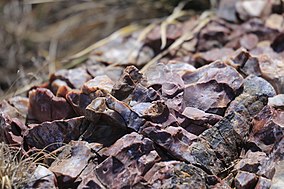
Landergin Mesa, near Vega, Texas, is an archeological site, preserving some of the most significant Texas Panhandle culture ruins. Landergin Mesa is a large site with many isolated structures, it is important because of the unique artifacts dating to the Antelope Creek Phase. There are well preserved examples of Borger Cordmarked ceramic vessels from the period. The site also exhibits unique architecture indicative of the Antelope Creek Phase.

The Mines of Spain State Recreation Area and E. B. Lyons Nature Center is a state park in Dubuque County, Iowa, United States. It is near Dubuque, the eleventh-largest city in the state. The park features picnic areas, 15 miles (24 km) of walking/hiking trails, 4 miles (6.4 km) of ski trails, and the Betty Hauptli Bird and Butterfly Garden. It also includes archaeological sites of national importance as an early lead mining and smelting venture led by French explorer Julien Dubuque, as well as Dubuque's gravesite. These sites were collectively designated a National Historic Landmark District as Julien Dubuque's Mines.
The Antelope Creek Phase was an American Indian culture in the Texas Panhandle and adjacent Oklahoma dating from AD 1200 to 1450. The two most important areas where the Antelope Creek people lived were in the Canadian River valley centered on present-day Lake Meredith near the city of Borger, Texas and the Buried City complex in Wolf Creek valley near the town of Perryton, Texas. Settlements are also found in Oklahoma near the town of Guymon and along the Beaver River.
The Trinchera Cave Archeological District (5LA9555) is an archaeological site in Las Animas County, Colorado with artifacts primarily dating from 1000 BC to AD 1749, although there were some Archaic period artifacts found. The site was added to the National Register of Historic Places in 2001 and is located on State Trust Lands.

Panhandle culture is a prehistoric culture of the southern High Plains during the Middle Ceramic Period from AD 1200 to 1400. Panhandle sites are primarily in the panhandle and west central Oklahoma and the northern half of the Texas Panhandle.

The Lynch Quarry site, also known as the Lynch Knife River Flint Quarry, and designated by the Smithsonian trinomial 32DU526, is a historic pre-Columbian flint quarry located near Dunn Center, North Dakota, United States. The site was a major source of flint found at archaeological sites across North America, and it has been estimated that the material was mined there from 11,000 B.C. to A.D. 1600. The site was designated a National Historic Landmark in 2011.