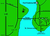
St. Simons Island is a barrier island and census-designated place (CDP) located on St. Simons Island in Glynn County, Georgia, United States. The names of the community and the island are interchangeable, known simply as "St. Simons Island" or "SSI", or locally as "The Island". St. Simons is part of the Brunswick metropolitan statistical area, and according to the 2020 U.S. census, the CDP had a population of 14,982. Located on the southeast Georgia coast, midway between Savannah and Jacksonville, St. Simons Island is both a seaside resort and residential community. It is the largest of Georgia's renowned Golden Isles. Visitors are drawn to the Island for its warm climate, beaches, variety of outdoor activities, shops and restaurants, historical sites, and natural environment.

Fort Matanzas National Monument was designated a United States National Monument on October 15, 1924. The monument consists of a 1740 Spanish fort called Fort Matanzas, and about 100 acres (0.4 km2) of salt marsh and barrier islands along the Matanzas River on the northern Atlantic coast of Florida. It is operated by the National Park Service in conjunction with the Castillo de San Marcos National Monument in the city of St. Augustine.

The Castillo de San Marcos is the oldest masonry fort in the continental United States; it is located on the western shore of Matanzas Bay in the city of St. Augustine, Florida.

Ocmulgee Mounds National Historical Park in Macon, Georgia, United States preserves traces of over ten millennia of culture from the Native Americans in the Southeastern Woodlands. Its chief remains are major earthworks built before 1000 CE by the South Appalachian Mississippian culture These include the Great Temple and other ceremonial mounds, a burial mound, and defensive trenches. They represented highly skilled engineering techniques and soil knowledge, and the organization of many laborers. The site has evidence of "12,000 years of continuous human habitation." The 3,336-acre (13.50 km2) park is located on the east bank of the Ocmulgee River. Macon, Georgia developed around the site after the United States built Fort Benjamin Hawkins nearby in 1806 to support trading with Native Americans.
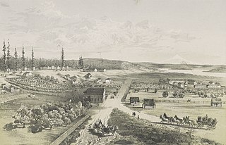
Fort Vancouver National Historic Site is a United States National Historic Site located in the states of Washington and Oregon. The National Historic Site consists of two units, one located on the site of Fort Vancouver in modern-day Vancouver, Washington; the other being the former residence of John McLoughlin in Oregon City, Oregon. The two sites were separately given national historic designation in the 1940s. The Fort Vancouver unit was designated a National Historic Site in 1961, and was combined with the McLoughlin House into a unit in 2003.

Sitka National Historical Park is a national historical park in Sitka in the U.S. state of Alaska. It was redesignated as a national historical park from its previous status as national monument on October 18, 1972. The park in its various forms has sought to commemorate the Tlingit and Russian experiences in Alaska.

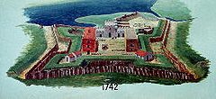
The Battle of Bloody Marsh took place on 7 July 1742 between Spanish and British forces on St. Simons Island, part of the Province of Georgia, resulting in a victory for the British. Part of the War of Jenkins' Ear, the battle was for the British fortifications of Fort Frederica and Fort St. Simons, with the strategic goal the sea routes and inland waters they controlled. With the victory, the Province of Georgia established undisputed claim to the island. The British also won the Battle of Gully Hole Creek, which took place on the island the same day.
The Golden Isles of Georgia consist of barrier islands, and the mainland port cities of Brunswick and Darien, on the 100-mile-long coast of the U.S. state of Georgia on the Atlantic Ocean. They include St. Simons Island, Sea Island, Jekyll Island, Little St. Simons Island, Sapelo Island, Blackbeard Island, Historic Darien and Historic Brunswick. The islands are part of a long chain of barrier islands known as the "Sea Islands", located along the coasts of South Carolina, Georgia and northern Florida.
The Battle of Gully Hole Creek took place on July 18, 1742 between Spanish and British forces in the Province of Georgia, resulting in a victory for the British. Part of a much larger conflict, known as the War of Jenkins' Ear, the battle was for control of St. Simons Island, the British fortifications of Fort Frederica and Fort St. Simons, and the strategic sea routes and inland waters they controlled. After the victory, the Province of Georgia established undisputed claim to the island, which is now part of the U.S. state of Georgia. The better-known Battle of Bloody Marsh, a skirmish also won by the British, took place on the island the same day.

Historic Jamestown is the cultural heritage site that was the location of the 1607 James Fort and the later 17th-century town of Jamestown in America. It is located on Jamestown Island, on the James River at Jamestown, Virginia and operated as a partnership between Preservation Virginia and the U.S. National Park Service as part of Colonial National Historical Park.

Fort Mose, originally known as Gracia Real de Santa Teresa de Mose, and later as Fort Mose, or alternatively, Fort Moosa or Fort Mossa, is a former Spanish fort in St. Augustine, Florida. In 1738, the governor of Spanish Florida, Manuel de Montiano, had the fort established as a free black settlement, the first to be legally sanctioned in what would become the territory of the United States. It was designated a US National Historic Landmark on October 12, 1994.

Fort King George State Historic Site is a fort located in the U.S. state of Georgia in McIntosh County, adjacent to Darien. The fort was built in 1721 along what is now known as the Darien River and served as the southernmost outpost of the British Empire in the Americas until 1727. The fort was constructed in what was then considered part of the colony of South Carolina, but was territory later settled as Georgia. It was part of a defensive line intended to encourage settlement along the colony's southern frontier, from the Savannah River to the Altamaha River. Great Britain, France, and Spain were competing to control the American Southeast, especially the Savannah-Altamaha River region.

The Wormsloe Historic Site, originally known as Wormsloe Plantation, is a state historic site near Savannah, Georgia, in the southeastern United States. The site consists of 822 acres (3.33 km2) protecting part of what was once the Wormsloe Plantation, a large estate established by one of Georgia's colonial founders, Noble Jones. The site includes a picturesque 1.5 miles (2.4 km) oak avenue, the ruins of Jones' fortified house built of tabby, a museum, and a demonstration area interpreting colonial daily life.
Manuel Joaquín de Montiano y Sopelana was a Spanish General and colonial administrator who served as Royal Governor of La Florida during Florida's First Spanish Period and as Royal Governor of Panama. He defended Florida from an attack by British forces in 1740 and launched his own unsuccessful Invasion of Georgia during the War of Jenkins' Ear.
In the 1742 Invasion of Georgia, Spanish forces based in Florida attempted to seize and occupy disputed territory held by the British colony of Georgia. The campaign was part of a larger conflict which became known as the War of Jenkins' Ear. Local British forces under the command of the Governor James Oglethorpe rallied and defeated the Spaniards at the Battle of Bloody Marsh and the Battle of Gully Hole Creek, forcing them to withdraw. Britain's ownership of Georgia was formally recognized by Spain in the subsequent Treaty of Madrid.

James Edward Oglethorpe was a British soldier, Member of Parliament, and philanthropist, and the founder of the Province of Georgia in what was then colonial-era British America. As a social reformer, he hoped to resettle Britain's "worthy poor" in the New World, initially focusing on those in debtors' prisons.
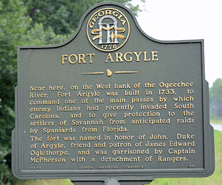
Old Fort Argyle Site is a historic site near Savannah. It is in Fort Stewart in Bryan County, Georgia. It was an English military settlement. It was added to the National Register of Historic Places on March 31, 1975. Access is restricted.

Fort St. Andrews was a British colonial coastal fortification built on Cumberland Island, Georgia, in 1736. The fort was built by the British as part of a buffer against Spanish Florida and the colonies to the north. The fort was abandoned and later destroyed by the Spanish in mid-1742.
Fort Prince Frederick was the southernmost fort in British North America from 1726 to 1758. Initially constructed of logs, it was later improved with tabby walls, which were completed in 1733. After the founding of Georgia on February 12, 1733 several other forts were constructed farther south, including Fort Frederica on St. Simons Island, diminishing the strategic importance of Fort Frederick. The fort is located in Port Royal, South Carolina.

Fort San Francisco de Pupo was an 18th-century Spanish fort on the west bank of the St. Johns River in Florida, about eighteen miles from St. Augustine, the capital of Spanish Florida. Lying on the old trail to the Spanish province of Apalachee in western Florida, Fort Pupo and its sister outpost, Fort Picolata on the opposite shore of the river, controlled all traffic on the ferry crossing. The remains of Fort Pupo are situated about three miles south of Green Cove Springs in Clay County, near the end of Bayard Point opposite Picolata. The surrounding area is a hammock of southern live oak, southern magnolia, pignut hickory and other typical trees native to the region.