Cumberland Island National Seashore

Last updated
Looking North from Dungeness runway. Kings Bay Naval Submarine Base can be seen in the upper left. CINS Beach, Looking North.jpg
Looking North from Dungeness runway. Kings Bay Naval Submarine Base can be seen in the upper left.
Cumberland Island National Seashore
USA Georgia location map.svg
Red pog.svg
Usa edcp location map.svg
Red pog.svg
Location Camden County, Georgia, US
Nearest city St. Marys, Georgia
Coordinates 30°50′N81°27′W / 30.833°N 81.450°W / 30.833; -81.450
Area36,415.39 acres (147.3679 km2)
18,700.34 acres (75.6776 km2) federal
EstablishedOctober 23, 1972
Visitors40,291(in 2005)
Governing body National Park Service
Website Cumberland Island National Seashore

Cumberland Island National Seashore preserves most of Cumberland Island in Camden County, Georgia, the largest of Georgia's Golden Isles. The seashore features beaches and dunes, marshes, and freshwater lakes. The national seashore also preserves and interprets many historic sites and structures.

Contents

Instrumental in the creation and preservation of the seashore were several conservation organizations including the Sierra Club and the Georgia Conservancy.

The island is only accessible by boat. The Cumberland Island Visitor Center, Cumberland Island Museum, and Lang concession ferry to the island are located in the town of St. Marys, Georgia. Public access via the ferry is limited, reservations are recommended. Camping is allowed in the seashore. The 9,886-acre (40.01 km2)Cumberland Island Wilderness is part of the seashore.

History

The national seashore was authorized by Congress on October 23, 1972, and is administered by the National Park Service. The wilderness area was designated on September 8, 1982. [1] It includes the High Point-Half Moon Bluff Historic District, which was listed on the National Register of Historic Places in 1978.

Biology and ecology

Marsh on Cumberland Island, nearby Plum Orchard Cumberland-island-marsh.jpg
Marsh on Cumberland Island, nearby Plum Orchard

Cumberland Island National Seashore contains a dense diversity of coastal flora and fauna. The National Park Service employs a full-time wildlife manager and scientists, and hosts researchers periodically. The park contains at least 23 distinct ecological communities, making it the largest and most biodiverse of Georgia's barrier islands. Birds, particularly migratory waterfowl, have been studied. [2] [3] [4] [5] [6]

Recreation

The public areas of Cumberland Island are part of a national seashore managed by the National Park Service. NPS restricts access to 300 people on the island at a time, and campers are allowed to stay no more than seven nights. The island is only accessible by boat. The Cumberland Queen ferry runs three times a day from March 1 to September 30. From October 1 to November 31 it only runs twice a day. From December 1 to February 28 the boat runs twice a day only on Mondays - Thursdays to Cumberland Island from the mainland (St. Marys, Georgia). Visitors cannot bring vehicles on the ferry, and there are no paved roads or trails. Bikes are available for rent at the Sea Camp Dock, on a first-come, first-served basis. Visitors may bring their own bikes on the ferry to the island for an additional charge. There is one camping area with running water and bathrooms with cold showers; the other camping sites do not have facilities. All food, ice and supplies must be shipped from the mainland, as there are no stores on the island.

South End Trail passes through a variety of plant communities including live oak maritime forest, beach, and pine-dominated forest. South End Trail in Cumberland Island National Seashore.jpg
South End Trail passes through a variety of plant communities including live oak maritime forest, beach, and pine-dominated forest.

Cumberland Island National Seashore Museum

The Cumberland Island National Seashore Museum is located in St. Marys, Georgia on the mainland entrance to the seashore, across from the park's visitor center. The main exhibit focuses on the island's history, including displays on the Timucua Indians, antebellum plantations, and the estates of the Carnegie family. It includes information about the lives of American Revolutionary hero General Nathanael Greene and cotton-gin inventor Eli Whitney, the history of the ruined mansion Dungeness and the Plum Orchard estate. A secondary exhibit holds one of the finest transportation exhibits in coastal Georgia, including wagons, carriages, and elite travel equipment. The new exhibit "Forgotten Invasion" describes the occupation of Cumberland Island and Camden County during the War of 1812. The museum is staffed by volunteers and is open on weekday afternoons.

Ice House Museum

The Ice House Museum was converted from one of the Carnegie service buildings. The museum showcases original artifacts and replicas from the island's prehistoric, colonial, early American and Gilded Era histories.

Plum Orchard and Dungeness

Plum Orchard Plum-orchard.jpg
Plum Orchard

The Dungeness and Plum Orchard were designated as National Historic Districts in 1982 and 1984 respectively. The Dungeness district contains the ruins of the Carnegie Dungeness mansion and its supporting structures and gardens, the Tabby House dating to the Early Republic, and a cemetery. The Plum Orchard Historic District contains the intact Plum Orchard mansion dating to the 1890s, a shell midden dating back over 4,000 years, and the mansion's support structures including an electrical house.

Climate

Cumberland Island National Seashore
Climate chart (explanation)
J
F
M
A
M
J
J
A
S
O
N
D
 
 
67
 
 
12
8
 
 
104
 
 
12
8
 
 
118
 
 
19
13
 
 
112
 
 
24
17
 
 
160
 
 
25
20
 
 
269
 
 
27
24
 
 
179
 
 
27
24
 
 
199
 
 
25
24
 
 
162
 
 
23
21
 
 
76
 
 
23
18
 
 
90
 
 
20
16
 
 
99
 
 
18
13
Average max. and min. temperatures in °C
Precipitation totals in mm
Source: [7]
Imperial conversion
JFMAMJJASOND
 
 
2.6
 
 
54
46
 
 
4.1
 
 
54
46
 
 
4.6
 
 
66
55
 
 
4.4
 
 
75
63
 
 
6.3
 
 
77
68
 
 
11
 
 
81
75
 
 
7
 
 
81
75
 
 
7.8
 
 
77
75
 
 
6.4
 
 
73
70
 
 
3
 
 
73
64
 
 
3.5
 
 
68
61
 
 
3.9
 
 
64
55
Average max. and min. temperatures in °F
Precipitation totals in inches

See also

Related Research Articles

<span class="mw-page-title-main">Gateway National Recreation Area</span> National Park Service unit in New York and New Jersey, United States

Gateway National Recreation Area is a 26,607-acre (10,767 ha) U.S. National Recreation Area in New York City and Monmouth County, New Jersey. It provides recreational opportunities that are not commonly found in a dense urban environment, including ocean swimming, bird watching, boating, hiking and camping. More than 8.7 million people visited Gateway National Recreation Area in 2022, making it the fourth-most visited unit of the National Park Service.

<span class="mw-page-title-main">Apostle Islands National Lakeshore</span> 69,372 acres in Wisconsin (US) managed by the National Park Service

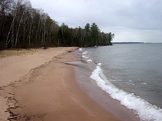
The Apostle Islands National Lakeshore is a U.S. national lakeshore consisting of 21 islands and shoreline encompassing 69,372 acres (28,074 ha) on the northern tip of Wisconsin on the shore of Lake Superior. It is known for its collection of historic lighthouses, sandstone sea caves, a few old-growth remnant forests, and natural animal habitats. It is featured on the America the Beautiful Quarters series.

<span class="mw-page-title-main">Fire Island National Seashore</span> National park system unit in New York, United States

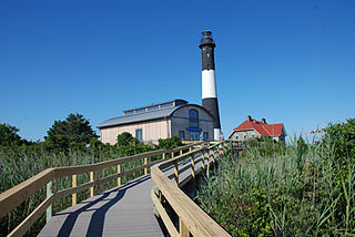
Fire Island National Seashore (FINS) is a United States National Seashore that protects a 26-mile (42 km) section of Fire Island, an approximately 30-mile (48 km) long and 0.5-mile (0.80 km) wide barrier island separated from Long Island by the Great South Bay. The island is part of New York State's Suffolk County and the Outer Barrier.

<span class="mw-page-title-main">Plum Orchard</span> United States historic place

Plum Orchard is an estate located in the middle of the western shore of Cumberland Island, Georgia, USA. The estate and surrounding area are listed on the National Register of Historic Places.

<span class="mw-page-title-main">Cumberland Island</span> Island in the U.S. state of Georgia

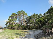
Cumberland Island, in the southeastern United States, is the largest of the Sea Islands of Georgia. The long-staple Sea Island cotton was first grown here by a local family, the Millers, who helped Eli Whitney develop the cotton gin. With its unusual range of wildlife, the island has been declared a National Seashore. Little Cumberland Island is connected to the main island by a marsh.

<span class="mw-page-title-main">Gulf Islands National Seashore</span> 96,000 underwater acres in Mississippi and Florida (US) managed by the National Park Service

Gulf Islands National Seashore is an American National seashore that offers recreation opportunities and preserves natural and historic resources along the Gulf of Mexico barrier islands of Florida and Mississippi. In 2022, it was the eighth-most visited unit of the National Park Service.

Shackleford Banks is a barrier island system on the coast of Carteret County, North Carolina. It contains a herd of feral horses, scallop, crabs and various sea animals, including summer nesting by loggerhead turtles. It is a tourist and beach camping site.

<span class="mw-page-title-main">Plum Island Range Lights</span> Lighthouse

The Plum Island Range Lights are a pair of range lights located on Plum Island in Door County, Wisconsin. Plum Island was transferred to the United States Fish and Wildlife Service in 2007 and became part of the Green Bay National Wildlife Refuge. Plum Island is seasonally open to the public for day-time use.

<span class="mw-page-title-main">Statue of Liberty National Monument</span> United States national monument

The Statue of Liberty National Monument is a United States National Monument comprising Liberty Island and Ellis Island in the U.S. states of New Jersey and New York. It includes the 1886 Statue of Liberty by sculptor Frédéric Auguste Bartholdi and the Statue of Liberty Museum, both situated on Liberty Island, as well as the former immigration station at Ellis Island which includes the Ellis Island Immigrant Hospital.

<span class="mw-page-title-main">Verrazano Bridge (Maryland)</span> Bridge in Assateague Island, Maryland

The Verrazano Bridge in Maryland is a bridge on Maryland Route 611 over Sinepuxent Bay that connects Assateague Island to the mainland.

<span class="mw-page-title-main">Protected areas of Georgia (U.S. state)</span>

The protected areas of Georgia cover almost one million acres (4,000 km2) of the state. These areas are managed by different federal and state level authorities and receive varying levels of protection. Some areas are managed as wilderness while others are operated with acceptable commercial exploitation. On the Federal level, Georgia contains 1 Biosphere Reserve, 15 National Park Service Managed Sites, 1 National Forest and 8 Wildlife Refuges. Georgia is home to 63 state parks, 48 of which are state parks and 15 that are National Historic Sites, and many state wildlife preserves, under the supervision of the Georgia Department of Parks and Recreation, a division of the Georgia Department of Natural Resources.

<span class="mw-page-title-main">Watch Hill (New York)</span> Camground and marina on Fire Island, New York

Watch Hill is a campground and marina located on Fire Island, a barrier island off the south shore of New York's Long Island. The park is located across the Great South Bay from Patchogue and is contained within the Fire Island National Seashore.

<span class="mw-page-title-main">Dungeness (Cumberland Island, Georgia)</span> Historic district in Georgia, United States

Dungeness on Cumberland Island, Georgia, is a ruined mansion that is part of a historic district that was the home of several families significant in American history. James Oglethorpe first built on Cumberland Island in 1736, building a hunting lodge that he named Dungeness. Oglethorpe named the place after the Dungeness headland, on the south coast of England. Dungeness was next the legacy of Revolutionary War hero Nathanael Greene, who had acquired 11,000 acres (45 km2) of island land in exchange for a bad debt. In 1803, his widow Catharine Littlefield Greene built a four-story tabby mansion over a Timucuan shell mound. During the War of 1812 the island was occupied by the British, who used the house as a headquarters.

<span class="mw-page-title-main">Stafford Plantation</span> Historic plantation in Georgia, United States

The Stafford Plantation was a plantation on Cumberland Island in Camden County, on the southeastern coast of Georgia. It was established in the early 19th century by Robert Stafford.

<span class="mw-page-title-main">Cumberland Island horse</span> American breed of horse

The Cumberland Island horses are a band of feral horses living on Cumberland Island in the state of Georgia. Popular myth holds that horses arrived on the island sometime in the 16th century with the arrival of the Spanish conquistadors. However, it is unlikely that any horses left by the Spanish survived, and more likely the current population descends from horses brought to the island in the 18th century by the English. Cumberland Island became part of the Cumberland Island National Seashore in 1972 when the National Park Service (NPS) took over its management. These horses are similar to the bands of horses living on the islands of Chincoteague and Assateague. There is estimated to be a population of between 150 and 200 horses on the island. Horses on Cumberland Island have a relatively short life expectancy, due to pest infestations, disease and their rugged environment. In 2000 a behavioral study found that instability marks the bands, with large numbers of co-dominant stallions, early dispersal of juveniles, and frequent band-changing among mares.

The Civil War Trust's Civil War Discovery Trail is a heritage tourism program that links more than 600 U.S. Civil War sites in more than 30 states. The program is one of the White House Millennium Council's sixteen flagship National Millennium Trails. Sites on the trail include battlefields, museums, historic sites, forts and cemeteries.

Carol Ruckdeschel is a biologist, naturalist, environmental activist and author. As a Cumberland Island resident, she was involved in the creation and preservation of Cumberland Island National Seashore. She is the subject of the book Untamed: The Wildest Woman in America and the Fight for Cumberland Island by Will Harlan.

<span class="mw-page-title-main">Greyfield Inn</span> Historic house in Georgia, United States

Greyfield is an estate with a Colonial Revival-style house of the same name on Cumberland Island in Camden County, Georgia; it was listed on the National Register of Historic Places in 2003. The inn is also a member of Historic Hotels of America, the official program of the National Trust for Historic Preservation.

<span class="mw-page-title-main">Lucy Carnegie Ferguson</span>

Lucy Carnegie Ricketson Ferguson was a member of the American industrialist Carnegie family who spent much of her life working to conserve Cumberland Island, the largest part of which was declared a national seashore in 1972. A granddaughter of Thomas Carnegie, her family once owned 90 percent of the island.

References

  1. Dilsaver, Lary M. (2004). Cumberland Island National Seashore: A History of Conservation Conflict. University of Virginia Press. pp. 128–. ISBN   9780813922683 . Retrieved 23 September 2014.
  2. Pearson, Scott M., Joan M. Walsh and John Pickering. (1992). Wood Stork Use of Wetland Habitats around Cumberland Island, Georgia. Colonial Waterbirds, Vol. 15, No. 1, pp. 33-42
  3. Whitaker, John O., Jr, & Ruckdeschel, C. (2013). Food of Eastern Moles, Scalopus Aquaticus, on Cumberland Island, Georgia. Georgia Journal of Science, 71(3), 167-172. (subscription required)
  4. Sprunt, Georgia Alexander, Jr. (July 1932). Some Notes from Cumberland Island, The Auk, Vol. 49, No. 3, p. 364
  5. Stockdon, Hilary F., David M. Thompson and Laura A. Fauver. (2007). Vulnerability of National Park Service beaches to inundation during a direct hurricane landfall: Cumberland Island National Seashore. Reston, Va. : U.S. Geological Survey.
  6. Fincher, G.T. and R. E. Woodruff. (March 1979) Dung Beetles of Cumberland Island, Georgia (Coleoptera: Scarabaeidae). The Coleopterists Bulletin, Vol. 33, No. 1, pp. 69-70.
  7. "NASA Earth Observations Data Set Index". NASA. Archived from the original on 6 August 2013. Retrieved 30 January 2016.
  8. Harlan, Will (2014). Untamed: the wildest woman in America and the fight for Cumberland Island (First ed.). New York: Grove Press. ISBN   9780802122582.