The Battle of Atlanta was a battle of the Atlanta Campaign fought during the American Civil War on July 22, 1864, just southeast of Atlanta, Georgia. Continuing their summer campaign to seize the important rail and supply hub of Atlanta, Union forces commanded by William Tecumseh Sherman overwhelmed and defeated Confederate forces defending the city under John Bell Hood. Union Maj. Gen. James B. McPherson was killed during the battle, the second-highest-ranking Union officer killed in action during the war. Despite the implication of finality in its name, the battle occurred midway through the Atlanta campaign, and the city did not fall until September 2, 1864, after a Union siege and various attempts to seize railroads and supply lines leading to Atlanta. After taking the city, Sherman's troops headed south-southeastward toward Milledgeville, the state capital, and on to Savannah with the March to the Sea.
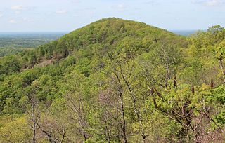
Little Kennesaw Mountain is a mountain in Cobb County, Georgia, northwest of Marietta and south of Kennesaw. It is a sub-peak of Kennesaw Mountain, the site of the Battle of Kennesaw Mountain in the 1864 Atlanta Campaign of the American Civil War.

The Battle of Resaca, from May 13 to 15, 1864, formed part of the Atlanta Campaign during the American Civil War, when a Union force under William Tecumseh Sherman engaged the Confederate Army of Tennessee led by Joseph E. Johnston. The battle was fought in Gordon and Whitfield Counties, Georgia, and is generally viewed as inconclusive.

The Atlanta campaign was a series of battles fought in the Western Theater of the American Civil War throughout northwest Georgia and the area around Atlanta during the summer of 1864. Union Maj. Gen. William Tecumseh Sherman invaded Georgia from the vicinity of Chattanooga, Tennessee, beginning in May 1864, opposed by the Confederate general Joseph E. Johnston.

The Battle of Peachtree Creek was fought in Georgia on July 20, 1864, as part of the Atlanta Campaign in the American Civil War. It was the first major attack by Lt. Gen. John Bell Hood since taking command of the Confederate Army of Tennessee. The attack was against Maj. Gen. William T. Sherman's Union army, which was perched on the doorstep of Atlanta. The main armies in the conflict were the Union Army of the Cumberland, commanded by Maj. Gen. George Henry Thomas and two corps of the Confederate Army of Tennessee.

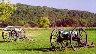
The Battle of Kennesaw Mountain was fought on June 27, 1864, during the Atlanta Campaign of the American Civil War. It was the most significant frontal assault launched by Union Maj. Gen. William T. Sherman against the Confederate Army of Tennessee under Gen. Joseph E. Johnston, ending in a tactical defeat for the Union forces. Strategically, however, the battle failed to deliver the result that the Confederacy desperately needed—namely a halt to Sherman's advance on Atlanta.

Tupelo National Battlefield commemorates the Battle of Tupelo, also known as the Battle of Harrisburg, fought from July 14 to 15, 1864, near Tupelo, Mississippi during the American Civil War. The Union victory over Confederate forces in northeast Mississippi ensured the safety of Sherman's supply lines during the Atlanta Campaign.

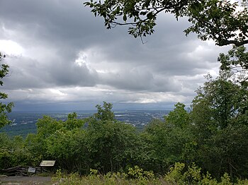
Kennesaw Mountain is a mountain between Marietta and Kennesaw, Georgia in the United States with a summit elevation of 1,808 feet (551 m). It is the highest point in the core metro Atlanta area, and fifth after further-north exurban counties are considered. The local terrain averages roughly 1,000 feet AMSL.
Wilson's Creek National Battlefield, located near Republic, Missouri, preserves the site of the Battle of Wilson's Creek. Fought on August 10, 1861, the battle was the first major American Civil War engagement west of the Mississippi River. In the battle, a Confederate army commanded by Benjamin McCulloch and Sterling Price defeated a smaller Union army commanded by Nathaniel Lyon. However, the Confederates were unable to hold much of Missouri, and a Confederate defeat at the Battle of Pea Ridge effectively solidified Union control of the state. Major features include a five-mile automobile tour loop, the restored 1852 Ray House, and "Bloody Hill", the site of the final stage of the battle. The site is located near Republic in southwestern Missouri just southwest of the city of Springfield. It has been a unit of the National Park Service since 1960, and was listed on the National Register of Historic Places in 1966.

Petersburg National Battlefield is a National Park Service unit preserving sites related to the American Civil War Siege of Petersburg (1864–65). The battlefield is near the city of Petersburg, Virginia, and includes outlying components in Hopewell, Prince George County, and Dinwiddie County. Over 140,000 people visit the park annually.

The Richmond National Battlefield Park commemorates 13 American Civil War sites around Richmond, Virginia, which served as the capital of the Confederate States of America for most of the war. The park connects certain features within the city with defensive fortifications and battle sites around it.

Benjamin Franklin "Frank" Cheatham was a Tennessee planter, California gold miner, and a general in the Confederate States Army during the American Civil War. He served in the Army of Tennessee, inflicting many casualties on Gen. Sherman at Kennesaw Mountain, Georgia, but took the blame for General Schofield's escape at Spring Hill, Tennessee – a major factor in the Confederate defeat at Franklin, Tennessee.

The Battle of Rocky Face Ridge was fought May 7–13, 1864, in Whitfield County, Georgia, during the Atlanta Campaign of the American Civil War. The Union army was led by Maj. Gen. William Tecumseh Sherman and the Confederate army by Gen. Joseph E. Johnston. Confederates were forced to evacuate their strong position due to a Union flanking movement.

The Battle of Marietta was a series of military operations from June 9 through July 3, 1864, in Cobb County, Georgia, between Union and Confederate forces during the American Civil War. The Union forces, led by Maj. Gen. William Tecumseh Sherman, encountered the Confederate Army of Tennessee, led by Gen. Joseph E. Johnston, entrenched near Marietta, Georgia.

The Battle of Kolb's Farm saw a Confederate corps under Lieutenant General John B. Hood attack parts of two Union corps under Major Generals Joseph Hooker and John Schofield. This action was part of the Atlanta campaign of the American Civil War fought between the Confederate Army of Tennessee led by General Joseph E. Johnston and Union forces commanded by Major General William Tecumseh Sherman. Hood believed that he had an opportunity to inflict a defeat on the Union forces in front of his corps and ordered an assault. However, Hooker's and Schofield's troops were deployed in good positions and they repulsed Hood's soldiers with serious losses.

Georgia was one of the original seven slave states that formed the Confederate States of America in February 1861, triggering the U.S. Civil War. The state governor, Democrat Joseph E. Brown, wanted locally raised troops to be used only for the defence of Georgia, in defiance of Confederate president Jefferson Davis, who wanted to deploy them on other battlefronts. When the Union blockade prevented Georgia from exporting its plentiful cotton in exchange for key imports, Brown ordered farmers to grow food instead, but the breakdown of transport systems led to desperate shortages.

Bentonville Battlefield is a North Carolina state historic site at 5466 Harper House Road in Johnston County, North Carolina. It belongs to the North Carolina Department of Natural and Cultural Resources and is the site of the 1865 Battle of Bentonville, fought in the waning days of the American Civil War. It was declared a National Historic Landmark in 1996.

The Battle of Bentonville was fought in Johnston County, North Carolina, near the village of Bentonville, as part of the Western Theater of the American Civil War. It was the last battle between the armies of Union Maj. Gen. William T. Sherman and Confederate Gen. Joseph E. Johnston.

Johnston's River Line, also called Johnston's Line, the Chattahoochee River Line or simply The River Line, is a historic American Civil War defensive line located in the communities of Mableton, Smyrna, and Vinings, Georgia that was used by the Confederate Army under General Joseph E. Johnston during the Atlanta Campaign in early July 1864. While no significant battles took place along the River Line, it remains one of the most impressive defensive fortifications ever constructed, often compared to the French Maginot Line built prior to World War II. Part of the River Line Historic Area and the Chattahoochee River Line Battlefield, the site today consists of the remains of Confederate earthwork battlements including unique fortifications called Shoupades, named after their designer, Confederate Brig. General Francis A. Shoup. The remains are spread across a six to seven mile stretch along the northwest side of the Chattahoochee River from a point just north of where Nickajack Creek joins the Chattahoochee in Mableton to north of S. Atlanta Road in Smyrna/Vinings. It was added to the National Register of Historic Places on July 5, 1973. Although many of the remains are on private property, visitors can access the site off U.S. 78 in Mableton, and off S.R. 280 and S. Atlanta Rd in Smyrna/Vinings. The site's coordinates are 33°47′31″N84°31′23″W.

The Illinois Monument is a public monument located in the Kennesaw Mountain National Battlefield Park in Cobb County, Georgia, United States. The monument honors the soldiers from Illinois who fought in the Battle of Kennesaw Mountain during the Atlanta campaign of the American Civil War. It is located on Cheatham Hill, the site of intense fighting during the battle, and was dedicated in 1914, on the 50th anniversary of the battle. It was designed by Mario Korbel and James Dibelka.