Carter County is a county in the Ozarks of Missouri. At the 2020 census, it had a population of 5,202. The largest city and county seat is Van Buren. The county was officially organized on March 10, 1859, and is named after Zimri A. Carter, a pioneer settler who came to Missouri from South Carolina in 1812.

The Ozarks, also known as the Ozark Mountains, Ozark Highlands or Ozark Plateau, is a physiographic region in the U.S. states of Missouri, Arkansas, Oklahoma and the extreme southeastern corner of Kansas. The Ozarks cover a significant portion of northern Arkansas and most of the southern half of Missouri, extending from Interstate 40 in central Arkansas to Interstate 70 in central Missouri.
The Ozark – St. Francis National Forest is a United States National Forest that is located in the state of Arkansas. It is composed of two separate forests, Ozark National Forest in the Ozark Mountains; and St. Francis National Forest on Crowley's Ridge. Each forest has distinct biological, topographical, and geological differences.

The Current River forms in the southeastern portion of the Ozarks of Missouri and becomes a 7th order stream as it flows southeasterly out of the Ozarks into northeastern Arkansas where it becomes a tributary of the Black River, which is a tributary of the White River, a tributary of the Mississippi River. The Current River is approximately 184 miles (296 km) long and drains about 2,641 square miles (6,840 km2) of land mostly in Missouri and a small portion of land in northeastern Arkansas. The headwaters of the Current River are nearly 900 feet (270 m) above sea level, while the mouth of the river lies around 280 feet (85 m) above sea level. The basin drains a rural area that is dominated by karst topography, underlain by dolomite and sandstone bedrock with a small area of igneous rock southeast of Eminence, Missouri. The annual daily mean discharge of the river near Doniphan, Missouri is 2,815 cubic feet (79.7 m3) per second. In 1964, over 134 mi (160 km) of the upper course of the river and its tributaries were federally protected as the Ozark National Scenic Riverways, the first national park in America to protect a river system.

The Ozark Trail is a hiking, backpacking, and, in many places, biking and equestrian trail under construction in the Missouri Ozarks in the United States. It is intended to reach from St. Louis to Arkansas. Over 350 miles (563 km) of the trail have been completed as of 2008, and the estimated length when finished will be at least 500 miles (805 km). When joined to the Ozark Highlands Trail in Arkansas, the full hiking distance from end to end will be at least 700 miles (1,127 km), not including a large loop through the St. Francois Mountains in Missouri.

Meramec State Park is a public recreation area located near Sullivan, Missouri, about 60 miles from St. Louis, along the Meramec River. The park has diverse ecosystems such as hardwood forests and glades. There are over 40 caves located throughout the park, the bedrock is dolomite. The most famous is Fisher Cave, located near the campgrounds. The park borders the Meramec Conservation Area.

Curecanti National Recreation Area is a National Park Service unit located on the Gunnison River in western Colorado. Established in 1965, Curecanti National Recreation Area is responsible for developing and managing recreational facilities on three reservoirs, Blue Mesa Reservoir, Morrow Point Reservoir and Crystal Reservoir, constructed on the upper Gunnison River in the 1960s by the U.S. Bureau of Reclamation to better utilize the vital waters of the Colorado River and its major tributaries. A popular destination for boating and fishing, Curecanti offers visitors two marinas, traditional and group campgrounds, hiking trails, boat launches, and boat-in campsites. The state's premiere lake trout and Kokanee salmon fisheries, Curecanti is a popular destination for boating and fishing, and is also a popular area for ice-fishing in the winter months.

The Lewis and Clark National Historic Trail is a route across the United States commemorating the Lewis and Clark Expedition of 1804 to 1806. It is part of the National Trails System of the United States. It extends for some 4,900 miles (7,900 km) from Pittsburgh, Pennsylvania, to the mouth of the Columbia River in Oregon.

Route 103 is a short highway in southeastern Missouri. Its southern terminus is at Route Z inside the Ozark National Scenic Riverways. The route travels north and intersects a few county roads as it leaves the national park. The road ends at U.S. Route 60 in a three-way junction. After being proposed in 1930, a road was built from the national park to US 60 in 1933. The gravel road was designated as Route 103, and it was paved five years later.
The Missouri National Recreational River is a National Recreational River located on the border between Nebraska and South Dakota. The designation was first applied in 1978 to a 59-mile section of the Missouri River between Gavins Point Dam and Ponca State Park. In 1991, an additional 39-mile section between Fort Randall Dam and Niobrara, Nebraska, was added to the designation. These two stretches of the Missouri River are the only parts of the river between Montana and the mouth of the Missouri that remain undammed or unchannelized. The last 20 miles of the Niobrara River and 6 miles of Verdigre Creek were also added in 1991.

Alley Spring is an unincorporated community in Shannon County, Missouri, United States. It is located six miles west of Eminence on Route 106. The scenic Alley Mill, or "Old Red Mill" is located there on a spring and is located in the Ozark National Scenic Riverways. The Mill is operated as an Ozarks history museum. Nearby a one room schoolhouse and general store add to the feeling of the restored historic hamlet. It once had a post office, but it is now closed and mail now comes from Eminence. The community is named after John Alley, a miller. It was originally named Mammoth Spring and later Barksdale Spring. These names were deemed too long by the Post Office Department of the time, so the village was renamed after a prominent local citizen, John Alley.

Montauk State Park is a public recreation area occupying nearly 3,000 acres (1,200 ha) at the headwaters of the Current River, fifteen miles (24 km) southwest of Salem, Missouri. The state park contains a fish hatchery and is noted for its rainbow and brown trout angling. It was acquired in 1926. The park has several natural springs including Montauk Spring with a daily average flow of 53 million gallons of water.

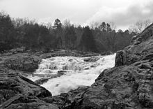
Big Spring is one of the largest springs in the United States and the world. An enormous first magnitude spring, it rises at the base of a bluff on the west side of the Current River valley in the Missouri Ozarks.
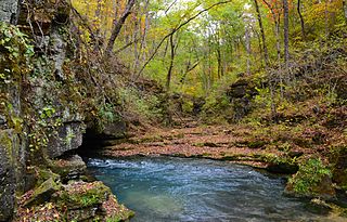
Greer Spring is a first magnitude spring located in the southeast portion of the Ozark Plateau, in Oregon County in south-central Missouri within the boundaries of the Mark Twain National Forest. The spring is the second largest spring in the Ozarks, with an average discharge of 360 cubic feet (10 m3) of water per second. Greer Spring was designated a National Natural Landmark in 1980.

The Eleven Point National Wild and Scenic River is a 44-mile (71 km) stretch of the spring-fed Eleven Point River in the Ozarks of southern Missouri set aside through eminent domain for preservation by Congress in 1968. The designated part of the river stretches from Thomasville to State Highway 142. The river was included in the original proposal for the Ozark National Scenic Riverways, but it was ultimately excluded when the Riverways were designated on the Current and Jacks Fork rivers in 1964.
Architects of the National Park Service are the architects and landscape architects who were employed by the National Park Service (NPS) starting in 1918 to design buildings, structures, roads, trails and other features in the United States National Parks. Many of their works are listed on the National Register of Historic Places, and a number have also been designated as National Historic Landmarks.
Devils Well is a sinkhole cave near Akers in the U.S. state of Missouri, containing an underground lake that is the largest in the state. It is a part of the Ozark National Scenic Riverways and can be viewed by the public any day during daylight hours. The U.S. Park Service has set up a metal staircase and a switch-activated light; however, it is recommended that visitors bring additional light sources.

Big Spring Historic District is a national historic district located at Van Buren, Carter County, Missouri. It encompasses 26 contributing buildings, 1 contributing site, and contributing structure in the Ozark National Scenic Riverways. It includes the Big Spring, rental cabins, service building, storage shed, garage, a museum, dining lodge, restroom, shelter house, ranger station, pump house, footbridge, and two picnic shelters. The structures represent the best features of park construction by the Civilian Conservation Corps in Missouri.

The Alley Spring Roller Mill, also known as Red Mill, is a historic grist mill located in the Ozark National Scenic Riverways near Eminence, Shannon County, Missouri. It was built in 1893, and is a 2 1/2-story, rectangular frame building on a limestone block foundation. It measures 32 feet by 42 feet and houses four steel rollers and a single stone burr.

Walter Klepzig Mill and Farm is a historic farm and sawmill and national historic district located in the Ozark National Scenic Riverways near Eminence, Shannon County, Missouri. The district encompasses three contributing buildings, three contributing sites, and one contributing structure associated with an early-20th century Ozark farm and mill. It developed between about 1912 and 1936 and includes the mill and its related hydraulic system ; a spring house and smokehouse ; foundations of a 1923 farmhouse and barn ; and two post-1934 chicken coops and a ruin of a post-1934 machine shed.